International Journal of Computational Engineering Research(IJCER) is an intentional online Journal in English monthly publishing journal. This Journal publish original research work that contributes significantly to further the scientific knowledge in engineering and Technology
How to Troubleshoot Apps for the Modern Connected Worker
ijcer
1. International Journal of Computational Engineering Research||Vol, 03||Issue, 9||
||Issn 2250-3005 || ||September||2013|| Page 35
Development of Physical Parameter Extraction Model for
Detection and Monitoring Flood Disaster
Wawan Setiawan1
and Wiweka2
1
Computer Science, Indonesia University of Education
2
Application Remote Sensing Center, Indonesia National Institute Aeronoutics and Space
I. INTRODUCTION
Flooding is a natural phenomenon that can be caused by natural factors, human factors, or a
combination of both. According to Richard (1955), flooding can be interpreted in two senses, namely: 1) the
overflow of river water caused by the river flow exceeds the capacity of the river in the state of high rainfall,
and 2) a puddle on the flat low-lying areas that normally do not flooded.Sudaryoko (1987) defines a flood as a
condition in an area where there is an increase in the amount of water that can not be accommodated in the
water channels or shelters so that the water overflowed and flooded areas outside of the channel, the river
valley, the water nor shelter. According Sutopo (1999), causes flooding can be divided into flooding problems
caused by natural events and conditions and flooding problems caused by the activity of the population.
Conditions and natural events such as heavy rainfall, a large amount of surface runoff, river water melimpasnya;
damming estuaries and tidal rivers from the sea. Factors influence the activity of the population flood events,
such as the growth of cultivated areas in floodplains, wetlands hoarding / situ or reclamation, narrowing the
river channel as a result of settlements along the river border, and control settlements along the river banks are
not implemented properly.Natural hazards, including floods can be seen from the characteristics of the danger,
which is of magnitude (magnitude, intensity) and frequency (Ayala, 2002).
Magnitude of flood hazards can be known from the extensive inundation, depth or water level, water
flow rate, material is washed away, water density or thickness of silt, long inundation, peak flow, and total flow
volume. While the frequency of flooding can be measured from the number of flood events in an area within a
certain time unit (Ayala, 2002).Flood disasters often cause harm either physically, economically, and socially
and culturally. Demands on the development of information technology often raises issues that were raised,
namely how the flood affected area distribution can be determined with more fast, precise, and accurate.
Additionally, Which areas affected by the floods. It is closely tied to the condition of land cover and
infrastructure affected by floodwaters.Remote sensing data are expected to be used to support flood mitigation
efforts. One of them is to provide fast and accurate information about the areas affected by the floods. This
study aims to develop a model of the physical parameter extraction from remote sensing data is for the detection
and monitoring of floods. The study will be conducted this research focuses on the study of literature on
methods of detection and monitoring of inundated areas using optical imagery, particularly Landsat and
MODIS.
ABSTRACT:
Natural hazards, including floods can be seen from the characteristics of the danger, which is
of magnitude (magnitude, intensity) and frequency. Remote sensing data can be used to support flood
mitigation efforts. This study aims to develop a model of the physical parameter extraction from remote
sensing data is for the detection and monitoring of floods. Research study conducted on the detection
and monitoring of inundated areas using optical imagery, particularly Landsat and MODIS.
Floodwaters identification method is done by comparing the values of reflectance and indices on
suspected areas affected by floods in the period before the flood, during the flood, and after the flood.
Parameter value is used reflectance reflectance in bands 1 to 7. While the parameter values used index
is NDVI, EVI, NDWI, MNDWI, LSWI and DVEL. Based on the results of the analysis seen that all
variables except LSWI can be used to detect the floodwaters. The study concluded that the MODIS
optical images can be used to identify a pool of water caused by floods.
KEYWORDS: Flood, Optical Image, Reflectance Parameters, Parameter Index Value
2. Development of Physical Parameter….
||Issn 2250-3005 || ||September||2013|| Page 36
II. PREVIOUS STUDIES
Floodwaters can be identified from remote sensing image based on the spectral appearance of objects that
exist in a puddle of water is. Wang et al. (2002) have developed an efficient method for mapping flood
inundation broad multemporal using Landsat imagery and Digital Elevation Model (DEM). The research took
place in North Carolina USA. The method developed is based on differences in spectral appearance of objects
by non-water water on the Landsat series before and during flood events. It also said the DEM data is helpful in
identifying flood. Wang et al. (2002) also stated that the method can be applied to a wide scope of areas with flat
topography. Furthermore, Wang (2004) have also conducted research using Landsat imagery recording date the
day after the flood event to determine the maximum extent of inundation on floodplains in coastal areas in the
same region (North Carolina USA). The resulting map accuracy rate in the range of 82.5 to 99.3%.Ho et al.
(2010) tried to flood hazard mapping using ASTER imagery, Landsat and DEM SRTM (Shuttle Radar
Topography Mission). The method used to separate the area flooded and non-flooded is MNDWI (Modified
Normalized Difference Water Index). Area of research taking place in the area in the alluvial plains Watershed
Vu Gia - Thu Bon System, Central Vietnam. This study reveals the close relationship between water-saturated
region, altitude, and flooding conditions in the area with water levels below 4 meters (classed as flood basins
and plains deltaik) that were flooded in the long term. The results showed that the method can be used to
separate MNDWI moist soil to predict flooding.Sakamoto et al. (2009) has developed the use of MODIS
imagery to evaluate the agro-ecological interpretation of rice farming systems in flood-prone areas in the
Mekong Delta of Vietnam. The parameters used was EVI (Enhanced Vegetation Index), LSWI (Land Surface
Water Index), and DVEL (Value Difference between EVI and LSWI). EVI parameters, DVEL LSWI and has
also been successfully used by Yan et al. (2010) to detect changes in spatial-temporal tidal flooding in the
wetlands (wetland) around the mouth of the river. Moreover, Islam et al. (2009) also uses parameters NDVI,
NDWI, and LSWI EVI from MODIS imagery to map flood inundation in Bangladesh and concluded that the
MODIS imagery is very useful to clarify the spatial-temporal distribution of flood inundation in Bangladesh.
III. PHYSICAL PARAMETERS EXTRACTION MODEL
Based on a literature review of the methods of identification floodwaters can be done by comparing the
reflectance values and indices on suspected areas affected by floods in the period before the flood, during the
flood, and after the flood. Parameter value is used reflectance reflectance in bands 1 to 7. While the parameter
values used index is NDVI, EVI, NDWI, MNDWI, LSWI and DVEL. Equation to calculate NDVI, EVI,
NDWI, LSWI, and DVEL as table 1.
Table 1. The Parameter Values Used Index
NDVI = Huete et al. (2002)
EVI = 2.5* Huete et al. (2002)
NDWI = McFeeters (1996)
MNDWI = Xu (2006)
LSWI = Xiao et al. (2006)
DVEL = EVI – LSWI Sakamoto et al. (2009)
Where ρNIR is near infrared reflectance (841-875 nm, MODIS band 2), ρRED red reflectance (621-670
nm, MODIS band 1), ρBLUE blue reflectance (459-479 nm, MODIS band 3), ρGREEN green reflectance (545 -
565 nm, MODIS band 4), ρSWIR short infrared reflectance (1628-1652 nm, MODIS band 6) (see Table 2).
3. Development of Physical Parameter….
||Issn 2250-3005 || ||September||2013|| Page 37
Table 2. Characteristic spectral and spatial resolution of MODIS reflectance channels 1-7
Channel
Central Wavelength
(nm)
Bandwidth
(nm)
Spatial resolution
(m)
1 645 620 - 670 250 m
2 858.5 841 - 876 250 m
3 469 459 - 479 500 m
4 555 545 - 565 500 m
5 1240 1230 - 1250 500 m
6 1640 1628 - 1652 500 m
7 2130 2105-2155 500 m
IV. RESULTS AND DISCUSSION
The data used in the application of the model is the preferred data remote sensing image acquired by
Space agency, which especially optical Landsat and MODIS imagery. Location chosen for the study is the
application of the model flood inundation areas in Banjar Regency South Kalimantan Province of Indonesia. At
the end of 2011 (December 2011), the flood-affected areas, where floods inundated 90 villages in the region are
home to about 68.264 inhabitants (BNPB, 2012).
BEFORE THE FLOOD
(August 2011)
IN THE FLOOD
(December 2011)
AFTER THE FLOOD
(June 2012)
R
G
B
6
2
1
B
A
N
D
-
1
4. Development of Physical Parameter….
||Issn 2250-3005 || ||September||2013|| Page 38
BEFORE THE FLOOD
(August 2011)
IN THE FLOOD
(December 2011)
AFTER THE FLOOD
(June 2012)
B
A
N
D
-
3
B
A
N
D
-
4
0 0.25
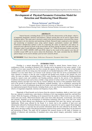
Figure 1. Floodwaters appearance on MODIS visible channel (1, 3 and 4). Red circles are the locations of
floodwaters
BEFORE THE FLOOD
(August 2011)
IN THE FLOOD
(December 2011)
AFTER THE FLOOD
(June 2012)
B
A
N
D
-
2
5. Development of Physical Parameter….
||Issn 2250-3005 || ||September||2013|| Page 39
BEFORE THE FLOOD
(August 2011)
IN THE FLOOD
(December 2011)
AFTER THE FLOOD
(June 2012)
B
A
N
D
-
5
B
A
N
D
-
6
B
A
N
D
-
7
0 0.5
Figure 2. Floodwaters appearance on MODIS infrared channels (2, 5, 6 and 7)
Figure 1 and 2 show 621 RGB MODIS imagery and MODIS reflectance per band (1-7) in the period before the
disaster, during disaster (floods) and after a disaster. Floodwaters location indicated by the red circle. The data
used is the 8 daily composite MODIS reflectance (MOD09). Data pre-disaster period selected in 2011 on 217
Julian Date (5 to 12 August 2011), the period during selected events in 2011 on 361 Julian Date (27 to 31
December 2011), and the period after the events selected in 2012 on 177 Julian Date ( 2 June to 2 July 2012).
Based on these data it can be seen that the reflectance MODIS band 2 (NIR), 5 and 6 (SWIR) provide better
results in detecting floodwaters as compared to other bands, especially the channel appears (visible).
6. Development of Physical Parameter….
||Issn 2250-3005 || ||September||2013|| Page 40
BEFORE THE FLOOD
(August 2011)
IN THE FLOOD
(December 2011)
AFTER THE FLOOD
(June 2012)
R
G
B
6
2
1
N
D
V
I
E
V
I
N
D
W
I
7. Development of Physical Parameter….
||Issn 2250-3005 || ||September||2013|| Page 41
BEFORE THE FLOOD
(August 2011)
IN THE FLOOD
(December 2011)
AFTER THE FLOOD
(June 2012)
M
N
D
W
I
L
S
W
I
0 1
D
V
E
L
0 5
Figure 3. Floodwaters appearance on MODIS NDVI, EVI, NDWI, MNDWI, LSWI, and DVEL
While Figure 3 shows the MODIS RGB image 621 and the calculation of the value of the index (NDVI,
EVI, NDWI, MNDWI, LSWI, and DVEL) are expected to be used for the identification of flood inundation.
Based on the results of the analysis can be seen that all variables except LSWI can be used to detect the
floodwaters.
V. CONCLUSIONS AND RECOMMENDATIONS
The study concluded that the MODIS optical images can be used to identify a pool of water caused by
floods. Physical parameters that can be extracted for identification of the floodwaters is reflectance value
channel 2, 5 and 6 and the index values are calculated from the reflectance values, such as NDVI, EVI, NDWI,
8. Development of Physical Parameter….
||Issn 2250-3005 || ||September||2013|| Page 42
MNDWI, and DVEL.Based on the results of this study should be followed up with a more focused research,
namely by applying models based on physical parameters of MODIS imagery for identification of flood
inundation, particularly for rapid mapping purposes (rapid mapping) flood affected areas.
REFERENCES
[1]. Ayala, I.A., 2002. Geomorphology, natural hazards, vulnerability and prevention of natural disaster in developing countries.
Geomorphology, 47,107-124.
[2]. McFeeters, S. K., 1996. The use of the Normalized Difference Water Index (NDWI) in the delineation of open water features.
International Journal of Remote Sensing, 17(7), 1425-1432.
[3]. Huete, A., K. Didan, T. Miura, E.P. Rodriguez, X. Gao, & L.G. Ferreira, 2002. Overview of the radiometric and biophysical
performance of the MODIS vegetation indices, Remote Sensing of Environment, 83, 195–213.
[4]. Ho, L.T.K., Umitsu, M., & Yamaguchi, Y., 2010. Flood hazard mapping by satellite images and SRTM DEM in the Vu Gia-Thu
Bon Alluvial Plain, Central Vitenam. International Archieve of the Photogrammetry, Remote Sensing and Spatial Information
Science, 38(8), 275-280.
[5]. Islam, A.K.., Bala, S.K., & Haque, A., 2009. Flood inundation map of Bangladesh using MODIS surface reflectance. 2th
International Conference on Water & Flood Management (ICWFM-2009.
[6]. Richard, B.D., 1955. Flood Estimation and Control, Ed-3. Chapman & Hall Ltd., London.
[7]. Sakamoto, T., Cao, P.V., Nguyen, N.V., Kotera, A., & Yokozawa, M., 2009. Agro-ecological interpretation of rice cropping
systems in flood-prone areas using MODIS imagery. Photogrammetric Engineering & Remote Sensing, 75(4), 413–424.
[8]. Sudaryoko, Y., 1987. Pedoman Penanggulangan Banjir. Badan Penerbit Pekerjaan Umum, Jakarta.
[9]. Wang, Y., Colby, J.D., & Mulcahy, K.A.., 2002. An efficient method for mapping flood extent in a coastal floodplain using
Landsat TM and DEM data. International Journal of Remote sensing, 23(18), 3681-3696.
[10]. Yan, Y.E., Ouyang, Z.T., Guo, H.Q., Jin, S.S., & Zhao, B., 2010. Detecting the spatiotemporal changes of tidal flood in the
estuarine wetland by using MODIS time series data. Journal of Hydrology, 384, 156–163.
[11]. Xu, H., 2006. Modification of normalised difference water index (NDWI) to enhance open water features in remotely sensed
imagery. International Journal of Remote sensing, 27(14), 3025-3033.