Unified model of the Yellowstone hotspot traces its 16-Ma evolution
•
1 like•181 views

This document summarizes research on the Yellowstone hotspot and the Yellowstone-Snake River Plain volcanic system. Key points include: 1) The linear progression of increasingly older silicic volcanic centers along the Snake River Plain provides evidence of the track of the Yellowstone hotspot as the North American plate moved over it. 2) Features like elevated topography, seismicity, and normal faulting surround the aseismic Snake River Plain in a "bow-wave" pattern, relating to the effects of the hotspot. 3) Geophysical data like low seismic velocities, high heat flow, and geoid anomalies provide further evidence that the Yellowstone system is fed by a mantle plume originating hundreds

Recommended
More Related Content
What's hot
What's hot (19)
Similar to Unified model of the Yellowstone hotspot traces its 16-Ma evolution
Similar to Unified model of the Yellowstone hotspot traces its 16-Ma evolution (20)
Recently uploaded
Recently uploaded (20)
Unified model of the Yellowstone hotspot traces its 16-Ma evolution
- 1. ELSEVIER Journal ofVolcanologyand Geothermal Research 61 ( 1994) 121- 187 Joumalofvolcanolol,~' and geothermalresearch The Yellowstone hotspot Robert B. Smith, Lawrence W. Braile DepartmentofGeologyand Geophysics, Universityof Utah,Salt Lake City, UT 84112-1183, USA DepartmentofEarth andAtmosphericSciences, 1397CivilEngineeringBuilding, PurdueUniversity, WestLafayette,IN 47907-1397, USA (Received June 12, 1993;revised version accepted August 3, 1993) Abstract Direct evidence for a plume-plate interaction as the mechanism responsible for the Yellowstone-Snake River Plain (YSRP), 16-Ma volcanic system is the observation of a linear age-progression of silicic volcanic centers along the Snake River Plain 800 km to the Yellowstone caldera -- the track of the Yellowstone hotspot. Caldera- forming rhyolitic volcanism, active crustal deformation, extremely high heat flow (about 30 times the continental average), and intensive earthquake activity at Yellowstone National Park mark the surface manifestations of the hotspot. Anomalously low P-wave velocities in the upper crust of the Yellowstone caldera are interpreted as solid- ified but still hot granitic rocks, partial melts, hydrothermal fluids and sediments. Unprecedented deformation of the Yellowstone caldera of up to 1 m of uplift from 1923 to 1984, followed by subsidence of as much as ~ 12 cm from 1985 to 1991, clearly reflects a giant caldera at unrest. The regional signature of the Yellowstone hotspot is highlighted by an anomalous, 600-m-high, topographic bulge centered on the caldera and that extends across a ~ 600-km-wide region. We suggest that this feature reflects long-wavelength tumescence of the hotspot. Yellow- stone is also the center of a + 10 m to + 12 m geoid anomaly, the largest in North America, and extends about 500 km laterally from the caldera, similar in width to the geoid anomalies of many oceanic hotspots and swells. The 16-Ma trace of the Yellowstone hotspot, the seismically quiescent Snake River Plain, is surrounded by "bow-wave" or parabolic-shaped regions of earthquakes and high topography. The systematic topographic decay along the Snake River Plain, totaling 1,300 m, fits a model of lithospheric cooling and subsidence which is consistent with passage of the North American plate across a mantle heat source. The 16-0 Ma rate of 4.5 cm/yr silicic volcanic, age progression of the YSRP includes a component of southwest motion of the North American plate, modeled at ~ 2.5 cm/yr, and a component of concomitant crustal extension estimated to be 1 to 2 cm/yr. The YSRP also exhibits anomalous crustal structure which we believe is inherited from magmatic and thermal processes associ- ated which the Yellowstone hotspot. This includes a thin, 2-5-km-thick surface layer composed of basalts and rhyolites and an unusually high-velocity (6.5 km/s), mid-crustal mafic layer that we suggest reflects extinct "Yel- lowstone" magma systems that have replaced much of the normal granitic upper crust. Direct evidence for a man- tle connection for the YSRP system is from anomalously low, P-wave velocities that extend from the crust to depths of ~ 200 km. These properties and the kinematics of the YSRP are consistent with an analytic model for plume-plate interaction that produces a "bow-wave" or parabolic pattern of upper-mantle flow southwesterly from the hotspot, similar to the systematic patterns of regional topography and seismicity. Our unified model for the origin of the YSRP is consistent with the geologic evidence where basaltic magmas ascend from a mantle plume to interact with a silicic-rich continental crust producing partial melts of rhyolitic composition and the character- istic caldera-forming volcanism of Yellowstone. Cooling and contraction of the lithosphere follows the passage of the plate over the hotspot with continuing episodic eruptions of mantle-derived basalts along the SRP. 0377-0273/94/$07.00 © 1994ElsevierScienceB.V. All rights reserved SSD10377-0273 (93) E0067-C
- 2. 122 R.B. Smith, L. W. Braille/Journal of Volcanologyand Geothermal Research 61 (1994) 121-187 I. Introduction Our knowledge of mantle hotspots has largely been derived from observations of active volcan- oes located primarily in oceanic settings. The Yellowstone-Snake River Plain (YSRP) vol- canic system of Idaho, Wyoming and Montana, including the Yellowstone silicic volcanic field and the related bimodal basaltic-rhyolitic vol- canic field of the eastern Snake River Plain, af- fords an opportunity to investigate the dynamics and properties of one of the Earth's largest sili- cic-dominated volcanic systems. We will de- velop a unifyingmodel for the origin of the YSRP which reflects plume-plate interaction that is consistent with observed geologic and geophysi- cal data. We will also show how the Yellowstone hotspot has affected more than 20% of the west- ern United States during its 16-Ma evolution (Fig. 1). The currently active element of the YSRP is a large caldera complex located at Yellowstone National Park, Wyoming. However, unlike most of the Earth's volcanic and tectonic features that are generally found at or near plate boundaries, Yellowstone National Park (loosely here called Yellowstone), is located ~ 2,000 km from the western margin of the North American plate. Yellowstoneis also located at the boundary of two major tectonic provinces, the Basin and Range and the Rocky Mountains. Here, the immense scale of its Pleistocene volcanism, extremely high heat flow (more than ~ 30 times the continental average), intense seismicity, widespread hydro- thermal activity, and unprecedented crustal de- formation makes Yellowstone a natural labora- tory for investigating volcanic and tectonic related processes (Fig. 2A). The occurrence of the 1983, Ms=7.3, Borah Peak, Idaho, earthquake has recently focused at- tention on the possible influence of the Yellow- stone hotspot on the seismotectonicsofthe YSRP (Smith and others, 1985 ). To examine this rela- tionship we plotted in Figs. 3 and 4, regional to- pography, locations of silicic volcanic centers, earthquakes, and late Cenozoic normal faults in a region that we believe has been affected by the hotspot. The most important features of Figs. 3 and 4 are: (1) a northeast progression of de- creasingly younger silicic volcanic centers along the YSRP; (2) "bow-wave" or parabolically shaped areas of high topography and seismicity surrounding the aseismic SRP; and (3) system- atic patterns of similar-aged normal faulting sub- parallel to the SRP which follow the general pat- terns of topography and seismicity. In this paper we will relate these features to a model for plume- plate interaction and show how the geophysical and geodetic data of the YSRP are consistent with a mantle, hotspot source. 1.1. What is a hotspot We associate the term "hotspot" with a geo- logic feature of long-lived active volcanism and high heat flux originating from the asthenos- phere and resulting in regional topographic uplift and undulations of the geoid. These features have been noted for various oceanic swells and linear tracks of oceanic volcanism as evidence of up- welling plumes. Our use of the term hotspot also reflects the generalized idea defined by Crough (1978 ) as "a region of mid-plate or anomalous ridge crest volcanism that is either persistent or accompanied by a broad topographic swell." These definitions encompass such oceanic fea- tures as the Hawaiian chain, the Cape Verde Rise, the Azores, and the Galapagos spreading center, all of which share properties similar to those of the YSRP. As discussed by Thompson and Gibson ( 1991 ), we expect that the hotspot location (de- fined by surface manifestations of deep-seated processes) is the site within the plane of the axis of an underlying plume. We thus define the Yel- lowstone hotspot as a large area of voluminous silicic volcanism that has evidence for a mantle heat and a basaltic magmatic source. Further discussions of hotspots and plumes are con- tained in recent reviews by Richards et al. (1989), Sleep (1990), and Duncan and Rich- ards ( 1991 ).
- 3. 48 ° R.B. Smith, L. IV..Braille/Journal of Volcanology and Geothermal Research 61 (1994) 121-187 126 ° 124 ° 122 ° 120 ° 118 ° 116 ° 114 ° 112 ° I I0 ° , , , WASHINGTON~~::.;,~ '~~',~ MONTANA 123 108 ° 46 ° Z W 0 0 #o 44 ° O IJ_ O <~ Q. iO.RE.G0_N YELL OWS TONE 42 ° 40 ° :%- r 0 0 WYOMIN( UTAH 124 ° 122 ° 120 ° 118 ° 116 ° 114 ° 112 ° I10 ° 0 500KM VOLCANIC ROCKS LESS THAN 17 m. y. OLD QUATERNARY BASALTIC ROCKS TERTIARY BASALTIC ROCKS CENOZOIC RHYOLITIC ROCKS CENOZOIC ANDESITIC ROCKS INTRUSIVE GRANITIC l-~ ULTRAMAFIC ROCKS / FAULTS SOURCES." VOLCANIC ROCKS-STEWART AND CARLSON (1978) NORMAL FAULTS AND INTRUSIVE ROCKS - KING (1969) STRIKE SLIP FAULTS - LAWRENCE (1976) Fig. 1. Generalizedtectonic map of the northwesternUnited States showing the Yellowstone and Snake River Plain region.
- 4. 124 R.B. Smith, L. W. Braille / Journal of Volcanology and Geothermal Research 61 (1994) 121- 18 7 (b)
- 5. R.B. Smith, L. IV. Braille/Journal of Volcanology and Geothermal Research 61 (1994) 121-187 125 1.2. The Yellowstone-Snake River Plain system The heart of Yellowstone National Park's majestic mountain scenery is a large Pleistocene, silicic volcanic field that is distinguished by three large calderas with a total eruptive volume of ~8,500 km3 (Christiansen and Blank, 1972; Christiansen, 1984, 1993). This area is best known for its spectacular display of geysers, fu- maroles and hot springs (Fig. 2A ). However, the accumulated effect of Yellowstone's volcanism is a ~ 2,500-m-high, relatively fiat and undulating mountainous terrain, termed the Yellowstone Plateau, which is surrounded by high peaks of the Rocky Mountains, some exceeding 4,000 m elevation. To the southwest, the Snake River Plain occu- pies an 800-km-long and 80-km-wide topo- graphic depression that descends to elevations of ~ 1,200 m in southwestern Idaho (Fig. 3). The Snake River Plain, covered primarily by late Cenozoic basalt flows, is underlain by silicic vol- canic rocks (Fig. 2B) similar in composition to those found in Yellowstone. The volcanic rocks age progressively to the southwest, from 0.6 Ma at Yellowstone to as old as 16 Ma in southwest- ern Idaho and northern Nevada (Armstrong et al., 1975 ). The systematic increase in the age of the silicic volcanic centers and the decrease in topography along the SRP are the best and most important surface manifestations of the Yellow- stone hotspot. We will show corroborating evi- dence from the geophysical and geodetic data for this hypothesized mantle source. 1.3. An early naturalist in Yellowstone We point out the role of Yellowstone, not only as one of the world's greatest scenic wonders, but as the birthplace of the U.S. National Park sys- Fig. 2. (A) Photograph of Steamboat geyser, Norris Junc- tion, Yellowstone National Park, in full eruption on July, 6, 1984 (photograph by Robert B. Smith). (B) Photograph of Big Southern Butte, a siliceous volcanic cone (in the far dis- tance) and Middle Butte, a basaltic cone (in the near dis- tance) on the Snake River Plain near Arco, Idaho (photo- graph by Lawrence W. Braile ). tem. Ferdinand V. Hayden ( 1872, 1873 ) was the first scientist to describe Yellowstone during his exploration of "Coulter's Hell", as it was known by fur trappers in the early 19th century for its rumored expanse of geysers and hot springs in a largely unexplored region of the Rocky Moun- tains. Hayden's perspective and championing of Yellowstone's geologic wonders and spectacular mountain scenery lead to the enactment of leg- islation in 1872 establishing the first national park in the world, Yellowstone National Park, and helped established the beginnings of the global environmental ethic. So impressed with Yellowstone's magnificent high mountain scenery and evidence of youthful volcanism, Hayden summarized an insightful interpretation of its origin that is valid today: "From the summit of Mt. Washburn, a bird's- eye view of the entire basin may be obtained with the mountains surrounding it on every side with- out any apparent break in the rim. This basin has been called by some travelers the vast crater of an ancient volcano. It isprobable that during the Pli- ocene period the entire country drained by the sources of the Yellowstone and the Columbia was the scene of as great volcanic activity as that of any portion of the globe. It might be called one vast crater, made up of thousands of smaller vo- calic vents and fissures out of which the fluid in- terior of the earth, fragments of rocks, and vol- canic dust werepoured in unlimited quantities". Hayden ( 1872 ) Hayden's ~experiences and insight into the sig- nificance of the scientific opportunities at Yel- lowstone are amplified by the views of Lt. Gus- tavus C. Doane, the military leader of an 1870 expedition into Yellowstone and cited from his personal journal entry on Sept. 24, 1870: "As a country for sightseers, it is without par- allel. As a field for scientific research it promises great results in the branches of Geology, Miner- alogy, Botany, Zoology, and Ornithology. It is probably the greatest laboratory that nature fur- nishes on the surface of the globe." ~Cited in Bonney and Bonney ( 1970, p. 387).
- 6. 126 R.B. Smith, L. W. Braille / Journal of Volcanology and Geothermal Research 61 (1994) 121-18 7 We will show throughout this paper that Yel- lowstone is indeed a window into the Earth's in- terior revealing information on such important processes as mantle-derived volcanism, mag- matic transport and heat flow, earthquakes, and surficial manifestations of plume-plate interac- tions. We will summarize the late Cenozoic vol- canic history of the YSRP, then describe the dis- tinctive physical properties of this system such as seismic velocity structure, heat flow, gravity and geoid fields, topographic features, and con- clude with a discussion of a plume-plate model which accounts for many of the observations. We will include a discussion of the geophysical and geological evidence regarding the space-time evolution and physical properties of the YSRP volcanic system as it pertains to an origin asso- ciated with a mantle hotspot. We conclude with a discussion emphasizing the corroboration of diverse geophysical findings of the YSRP with the results of volcanological, geomorphic and petrological studies and comment on the unu- sually good agreement between these data and a unified model for plume-plate interaction as the responsible mechanism for the Yellowstone hotspot. 2. Track of the Yellowstone hotspot-the Snake River Plain The volcanic history of the Snake River Plain is not as well known as that of Yellowstone, pri- marily because most of the late Cenozoic silicic volcanic rocks and related calderas are buried beneath youngerbasalts (Figs. 2B, 3). Nonethe- less, the first definitive evidence for a systematic time-progressive volcanic origin of this region was recognized by Armstrong et al. (1975) who mapped and dated silicic volcanic rocks along the Snake River Plain. Morgan et al. (1984) em- ployed paleomagnetic methods and identified several large calderas in the northern part of the SRP with dimensions similar to those of Yellow- stone. We also refer the reader to a summary of the evolution of the Snake River Plain volcanic system by Leeman (1982) based on petrology and trace-elementanalysis of volcanic rocks. Discussions of the YSRP must also include its possible relationship to the Oligocene Columbia Plateau basalt field of western Oregon and Washington that has been attributed by several authors to a mantle plume. For example, Thompson (1977) and Draper ( 1991 ) sug- gested that the short-lived magrnatism of the Co- lumbia Plateau volcanic field was fed by upper- mantle dikes from a "Yellowstone" plume lo- cated in southwestern Idaho, 16-17 Ma. While there is no time progression ofthe Columbia Pla- teau basalts, the immense scale of this volcanic field suggestsa mantle source that cannot be ruled out. However, there is little geophysical data on the Columbia Plateau or on its transition to the Snake River Plain to evaluate this supposition. We, therefore, will not attempt to address the possible relationships between these provinces, but offer in a later section reasons why we be- lieve that the YSRP is not directly related to this flood basalt province. 2.1. Ages progression ofsilicic volcanic centers The best evidence for systematicmotion of the North American plate across a mantle magmatic source is the progressive decrease in ages of K/ Ar dated, silicic volcanic rocks along the YSRP (Fig. 5). The youngest silicic volcanic centers correspond to the Yellowstone volcanic field which are less than 2.0 Ma and are followed by a sequence of silicic centers at about 6 Ma, south- west of Yellowstone. A third group, near ~ 10 Ma, is centered near PocateUo, Idaho. The oldest mapped silicic rocks of the SRP are ~ 16 Ma, are distributed across a 150-km-wide zone in south- western Idaho, southwestern Oregon and north- ern Nevada, the suspected origin of the YSRP (Fig. 3). Appendices I and II contain the data used in our linear regression models shown in Fig. 5. Also see Table 1 for a compilation of data re- lating to plate motions of the YSRP. A 3.5-cm/yr systematic decrease in age for sil- icic volcanic rocks of the YSRP was first de- scribed by Armstrong et al. (1975). However, these authors did not speculate on a causative mechanism. Since Armstrong's pioneering work on the Snake River Plain, his results have been
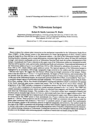
- 7. R.B. Smith, L. W. Braille/Journal of Volcanologyand GeothermalResearch61 (1994)121-187 127 cited by various authors as evidence for the track of the North American Plate across a mantle plume. Smith (1990) and Smith et al. (1990) used Armstrong's data and calculated a 4-cm/yr rate for the silicic age progression which is simi- lar to the rate of 4.5 cm/yr given by Rodgers et al. (1990). We have also calculated the silicic age progres- sion rate by fitting a linear regression of silicic volcanic ages and location along the YSRP (Fig. 5). Our analyses show an average rate of silicic age progression of 4.5 cm/yr for 20-0 Ma, simi- lar to that of several of the others cited here. However, we think that the data distinguish two regimes: (1) for the 0-8-Ma period we deter- mined a rate of 3.3 cm/yr, and (2) for the 16-8- Ma period we calculated a rate of 6.1 cm/yr. We note that variations in the rates of age progres- sion may be due in part to varying episodes of superimposed Basin and Range extension, to the combined scatter of the reported dates by var- ious authors, and to the spatial variations in the reported locations and widths of the silicic cen- ters. Nonetheless, the 0-16-Ma averages for all reported age rates fall within 4_+ 1 cm/yr. 2.2. Plate tectonic models The first recognition of the effects of plate mo- tion at Yellowstone was by Morgan ( 1972 ) who calculated a southwest-trending vector for the North American plate of 1-2 cm/yr from a hy- pothesized plume beneath Yellowstone with a track along the Snake River Plain2. A plate mo- tion vector at Yellowstone of 2.5 cm/yr and at an azimuth of 245 ° was calculated by Smith and Sbar (1974) for the relative motion between the North American plate at Yellowstone with re- spect to the Juan de Fuca and Pacific plates. They also calculated a rate of 4.5 cm/yr and at 245 ° azimuth for plate motion at Yellowstone con- strained by a 6-cm/yr rate of interplate motion between the North American and Pacific plates along the San Andreas fault. Using an average 2Note that these azimuths are for the direction of plate mo- tion and are opposite to the directions implied by the pro- gression of silicic ages. displacement rate of 2.4 cm/yr along the San Andreas fault (Wallace, 1990) and the same data as Smith and Sbar (1974), we calculated a plate motion rate at Yellowstone of 3.4 era/yr. These rates compare well with values determined from global multi-plate inversion of 2 to 3.1 cm/yr at Yellowstone (Table 1). The differences in the various plate motion vectors come from errors in the calculated Euler poles produced by varia- tions in such data as oceanic paleomagnetic anomalies, slip vectors from earthquakes, and the various assumptions of net-rotation and net- torque models. The most recent models of plate motion of Yellowstone are from DeMets et al. (1990) who determined rates of North American plate mo- tion using variations of the multi-plate model, NUVEL-1, and incorporated fixed hotspot models of Gripp and Gordon (1989, 1990). Their calculations yielded plate velocities at Yel- lowstone of 0.9 cm/yr to 2.5 cm/yr. We have used a rate of ~ 2 cm/yr that is averaged for the absolute plate motion at Yellowstone by exclud- ing the extreme values of multiplate NUVEL-1 models (Table 1). 2.3. Rate of extension inception We note that the rates of plate motion implied by the silicic age progression (Armstrong et al., 1975 ) include the accompanyingextension of the SRP crust. Richard Armstrong first suggested to one of us (RBS), the apparent progression in in- ception of normal faulting adjacent to the Snake River Plain that he believed reflected the re- gional extension related to the age progressive silicic volcanism. Scott et al. ( 1985 ) and Pierce and Morgan (1990) noted similar progressions 6f inception of normal faulting along the SRP, while Rodgers et al. (1990) used the ages of in- ception of sedimentation in basins on the south side of the SRP as evidence for inception of re- gional extension (Fig. 5). We have also examined the rates of inception of crustal extension by modeling the ages of in- ception of sedimentation given by Rodgers et al. (1990), but excludedthe Teton fault because new evidence suggests that this feature may have
- 10. R.B. Smith, L. W. Braille/ Journalof Volcanologyand GeothermalResearch61 (1994)121-187 135 A 10 Ages of Silicic Volcanic Center Progression Along YSRP NE Distance from Yellowstone Hotspot (km) SW 0 100 200 300 400 500 600 700 800 0 5 --~ 16-0 Ma , i ' C---. / 4.5cm/yr 8- 0 Ma 3.3 cm/yr ~. [ i 15 ~ " ",~ 20 16.8Ma / I 6.1 cm/yr I B NE Ages of Inception of Extension Along YSRP SW Distance from Yellowstone Hotspot (kin) 100 200 300 600 700 800 0 5 k 10 - 15-- 20 --.. 8-OMa ..~'~ 1.3 cm/yr 400 500 ~ - - ~ . - . . . . . _ 16 - 0 Ma 4.3 cm/yr / i i 16-8 Ma IX-" s.7 c~yr ( Fig. 5. (A) Calculated rates of silicic volcanic age progression (ages of silicic volcanic rocks from Armstrong et al., 1975). (B) Rates of inception of crustal extension (data from Rodgers et al., 1990) for the YSRP. See Appendix I and II for data used to construct the regression models. Solid lines are fits to all of the data. Dashed lines are fits to data in two periods: 0-8 Ma and 10-16 Ma.
- 11. I ~, R B S'mith. I H Brattlc .'.lourp,j! m I :d,'(m~doC, vand (,c+*llu>rmai R~>.scar('/7.6 ! , fu94J :) i i?7- evolved as early as Miocene time (Byrd and Smith, 1991 ). From our calculations (Fig. 5), we suggest that the ages of extension inception re- flect the same two regimes as noted in the silicic volcanic age progressions. In the first phase, from 16 to 8 Ma, the rate of inception of extension of 5.7 cm/yr compares with the rate of 6. l cm/yr from the age progression of silicic volcanic cen- ters (Fig. 5). While for the younger regime of 10- 0 Ma, the rate of extension inception of 1.3 cm/ yr is smaller than the silicic age rate of 3.3 cm/ yr. Our 16-0 Ma rate was 4.3 cm/yr which is re- markably similar to the silicic age progression rate of 4.5 cm/yr. How Pacific and North American plate mo- tions have affected the SRP evolution during its 16 Ma history was first discussed by Pollitz ( 1988 ). He made calculations of age rates based upon the silicic ages and moreover noted two re- gimes: ( 1) the first, 20-10 Ma with a rate of 3. I cm/yr at an azimuth of 267'~; and (2) the sec- ond, 9-0 Ma, marked by a change in azimuth to 234 " with a rate of 2.9 cm/yr (Table t J. Our model (Fig. 5 ) also reveals the change at 10 to 8 Ma that we believe marks a decrease in the rela- tive rates of either plate motion or extension rate. Pollitz (1988) attributed the change in plate di- rection at ~ 9 Ma to either a plate reorientation or to a change in the magnitude of plate forces acting on the northwest plate margin on the Pa- cific plate. We note that the 10-8 Ma change is also near the time of a major 45 :~counterclock- wise rotation of ahmm from ENE-WSW to WNW-ESE in the northern Basin and Range at approximately 10 Ma (Zoback et al., 1981). Thus the change in age and the inception of ex- tension at 10-8 Ma on the YSRP may be associ- ated with late Cenozoic intraplate adjustment of the western U.S. Effect of crustal extension on estimates Ofplate motions An important factor not incorporated into previous estimates of Yellowstone plate motion is the effect of concomitant crustal extension as- sociated with the Basin and Range opening. We estimated the long-term extension rate of the SRP by subtracting the age-progression rate deter- mined from the ages of silicic volcanic rocks and that we assumed reflects both the combined ef- fects of extension and plate motion, from the modeled plate motion rates. As shown in Fig. 5.. this suggests, for the period 9-0 Ma, an exten- sion rate of ~ 1-2 era/yr. We note that distin- guishing extension from plate motion is critical to analytical models of plate-plume interaction that will be discussed in later sections, as well as for differentiating magmatic related detbrma- tion from crustal extension inferred l¥om geo- logic data, 2.4. Topographic expre~'sion of the YSRP Perhaps the most striking surface feature of the YSRP is the systematic decrease in average ele- vation along the Snake River Plain from ~ 2,500 m at the Yellowstone Plateau, southwest 800 km to southwestern Idaho at an average elevation of 1,200 m (Fig. 3). The SRP depression is about 80 km in width and generally corresponds to the extent of basaltic volcanism. However, we point out a ~ 15° change in direction at about 250 km from Yellowstone (Fig. 3 ) which appears to be related to the plate reorientation at 10-8 Ma dis- cussed in the previous section. Arcuate topographic highs extend southwest from Yellowstone in two .branches to form a "bow-wave" or parabolic-shaped pattern of high topography surrounding the depression (Fig. 3 ). The systematic topography of the SRP was first recognized by Myers and Hamilton ( 1964 ) who pointed out the arcuate pattern of surrounding earthquakes and suggested they were the result of general topographic collapse. Suppe et al. ( 1975 ) hypothesized that the topographic dom- ing of the Yellowstone Plateau was due to a man- tle plume. The topographic rims surrounding the SRP were also discussed by Smith et al. (1985) and Smith (1989) in their assessments of the seismotectonics of the YSRP and by Anders et al. (1989) and Anders and Sleep (1992), who ascribed the systematic parabolic-shaped topog- raphy of the YSRP to the Yellowstone hotspot. Pierce and Morgan (1990, 1992) have also as- sociated the topography with a crescent shaped
- 12. R.B. Smith, L. 14:.Braille / Journal of Volcanologyand Geothermal Research 61 (1994) 121-187 137 uplift, warping around Yellowstone, which they also attributed to a mantle hotspot. Lithospheric deformation associated with large-scale mantle processes generally has an ob- servable response in river drainage systems. To examine this possibility, we plotted the rivers and streams of the YSRP and surrounding region (Fig. 6). The resulting pattern reveals the high topographic divides surrounding the SRP which separate the Snake River and the Salmon River drainages to the northwest and the Great Basin and ancestral Snake River drainages to the southeast. The highest topography is associated with the topographic divides at 1,500 to 2,000 m in elevation (also shown in Fig. 3). The border- ing topographic shoulders extend southwest- ward from Yellowstone for 400 km wrapping around the SRP in the characteristic parabolic pattern. The width between the drainage divides increases to ~200 km, 300 km southwest of Yellowstone. We also plotted on Fig. 5 the locations of the larger, Ms> 5.7, earthquakes of the region which demonstrates an important characteristic, namely that the background seismicity is gener- ally located in the areas of the SRP drainage di- vides (except for the 1983 Borah Peak nuclea- tion point which is 25 km southeast but its surface rupture extends northwest beyond the drainage divide). This correlation suggests a re- lated mechanism for the topography and seism- icity (Smith et al., 1985 ) which we believe is as- sociated with the Yellowstone hotspot and its interaction with an overriding lithospheric plate. Missouri River drainage ' '~)-::--,'~, "'~ ' : "M60'~A¢'-'--M6.1-~-~ ~'~ . .. , :, .~-'.. -:, ' ,:" : ?:.-5 ~..'~ i '_ M6.5, 6.5 rellowstone .- .e ( ~k , ,'1.," ""--"'- .... ' / ; --ii," ,N''~.'-'~"z, ~' / .'" ',QU ~ - ~- , ,I -', '..e "'~ : ..4" ' ', ~J/'."l .: ,'tl --"" ,,- -,'-L-->:--'~"..... ~o~, 's-': _ -'. -~L~---.--cXd,: - ~'~--- _.. e.~.~.--. ~" ~,,~e ~M7.3 • :..%, . . - .'.:~.I )LL.c .,_ .. ':- '>", -~"--.:-'~.' , ~ " "* ~.-. / I k ~..:"---% ::- - ,' I"" II¢" /' - " "-" -ii-"' "0 v -. ' ~ ' ~ . " ' ~ , ' ~.,'~".;, '.~... , , I," -, , I '~: , , , , '"~" !~ ,,.--~' ', I, ' , ' 150 0 50 OOkm .... ',. ,.c.oke, ..c~-~-~_~_-.--~- ,--*-~ , ,,-~-- ,-~/--~ ", .- ." ,',"'~,,:-':/,,, ",:',': ; ,'~ ,. ',I, ;., | -:../ .'Off,-,' : I-' , ",, ~ , (~.'~yA A I '.' ,', ~-".-~',/,~".,,~, .' k ~ ' ' ' 'L' ",'~4~' ;' ' Great "Basin drainage Fig. 6. Drainage patterns of the upper Snake River basin and surrounding regions of the YSRP. Light dashed lines correspond to rivers and streams, bold dashed lines are the main drainage divides. Epicenters of the larger, M,>~ 5.7, historic earthquakes from Table 3 are shown.
- 13. 138 R.B. Smith. L. I~~Brai/tc '.hmrna/ ~1I ;dcano/o~'t' and Ge lherm~d Rc~em',';; ¢, / '/,;uJ. ! ? ; /.~ - The residual topography of the Yellowstone Plateau and the Snake River Plain (Fig. 7) also reveals anomalous properties. For Yellowstone, the topographic residual was determined by ra- dially averaging digital elevation data out to dis- tances of 400 km. We selected the Yellowstone data in two azimuthal windows: (I) to the northeast; and (2) to the southwest. This reveals an asymmetric but distinct ~ 600-km-wide top- ographic anomaly of up to 600 m in height that we suggest reflects the region now affected by the Yellowstone hotspot (Fig. 7 ). We also note that the area of the anomalous topography is more than ten times larger than the ~ 2,500 km 2 Yel- lowstone caldera and encompasses the nearby Hebgen Lake fault zone to the west, parts of the Teton Range to the south, and the Absaroka and Beartooth Ranges to the east--the general defi- nition of the Yellowstone Plateau. Downdropping of the SRP is revealed by a 300- km-long, residual topographic profile (Fig. 7) The SRP topographic residual anomaly was pro- duced by removing a long-wavelength linear trend from the digital topographic profile across the SRP exhibits a pronounced 200-300 m depression surrounded by topographically high shoulders with relief in excess of 400 m. The sur- rounding uplift shoulder and central subsidence anomaly have a dimension of ~ 650 kin, about the same width as the regional topographic uplift anomaly of the Yellowstone Plateau. E ,-n 1000 - - Radialy a~eraged topography of the 't elh~*sllme Plateau r 800 _ .... NNVV-SSI,', profile of smoothed topl)graplD across the ~';RP 600 - - Yellowstone ab.~l200 ~_, Yellowstone hotspot 0 .~ ~ j u p l i f t anomal.~ / -2oo SRP / --. ~/ River Plain "~x Snake -400 subsidence anoma0 / ="~ - f // // -600 N.~W ~ SSe I -400 -200 0 200 400 Distance (krn) / ~........ index Map/ 'X 1 I I / ~ u°r'tan~ I __/'~ ~ , " .E Nev I °'"" / Fig. 7. Topographic anomalies of the Yellowstone Plateau and the Snake River Plain. The Yellowstone topographic anom- aly was determined by radially averaging (smoothing) the digitized topography, in Fig. 3, out to distances of 400 km. The Snake River Plain residual topography was computed by removing a linear regional trend and plotted along a general NNW-trending profile from Salmon, Idaho (north of the SRP), across the SRP (zero distance), to Tremonton, Utah (south of the SRP). 2.5. Comparison~/ YSRP topographywith mantle hotspot.~ The long-wavelength topographic response of the Yellowstone hotspot (Fig. 7) can be com- pared with that of oceanic hotspots such as the Cape Verde, Galapagos, Azores and Hawaiian islands (Crough, 1983). Topographic highs as- sociated with these features range from 1to 2 km above the abyssal plain and their widths range from 700 km to 1,500 km (Table 2). We caution that there may not be a direct one-to-one com- parison between the topography of Yellowstone and the oceanic features because of differing thicknesses and compositions of oceanic versus continental crust, age of crust, and thermal re- gimes. Nonetheless the 600-km-wide topo- graphic anomaly (Fig. 7 ) and the ~ 1,000-km- wide geoid anomaly (to be discussed in a later section) of Yellowstone is similar to those asso- ciated with oceanic swells and hotspots and pro- vides corroborative evidence for a mantle origin of Yellowstone. We note the striking similarity between the anomalous Yellowstone topography (Fig. 7 ) with the excess lithospheric topography modeled by Hill et al. (1992) for a rising mantle plume in- teracting with a stationary continental litho- sphere, i.e., without shearing of the top of the plume at the base of an overriding plate. They suggested up to 500 m of excess topography
- 14. R.B. Smith, L. IV..Braille/Journal of Volcanology and Geothermal Research 61 (1994) 121-187 Table 2 Topographic and geoid characteristics of the Yellowstone-Snake River Plain volcanic system 139 Long wave length topography Width Height/Subsidence (km) Yellowstone Plateau Radially averaged topography (Fig. 6 ) 600 ~ 650 m Snake River Plain Width of volcanic province, Zone I, 300 km SW of Yellowstone (Fig. 3) Width of Zones I and II, 300 km SW of Yellowstone (Fig. 3) Maximum width of Zones I, II and III, 500 km SW of Yellowstone (Fig. 3) ~ 80 ~ 200 m ~ 250 600 Oceanic swells : Hawaiian 1100 2 km Cape Verde Rise 1500 2 km Azores 1500 2 km Galapagos 900 1 km Yellowstone Hotspot geoid anomaly GEOID90 model 3 (Fig. 7) ~ 1,000 +10 m to +12 m anomaly At 300 km distance from Yellowstone. The Snake River Plain has subsided an additional 200 m with respect to the averaged topography of the Yellowstone Plateau. 2 From Crough (1983). 3 From Milbert ( 1991 ). across 1,000-m-wide zones and describe the YSRP as a "plume tail province." This width compares with that of Yellowstone, however we assume there is a significant component of shearing of mantle material accompanying the plume-plate interaction of the North American plate, plus a component of concomitant plate ex- tension. We will discuss our plume-plate model for Yellowstone in a later section. 2.6. Patterns of late Cenozoicfaulting We discuss the style of late Cenozoic normal faulting of the YSRP and its related deforma- tional patterns (Fig. 3) using a compilation of late Tertiary to Holocene normal faults taken from Smith and Arabasz ( 1991 ). The systematic pattern of Late Quaternary faulting paralleling the YSRP was originally noted by Smith et al. ( 1985 ), Scott et al. ( 1985 ) and Pierce and Mor- gan (1990, 1992) as evidence as causative fea- tures of the Yellowstone hotspot. Here we differ- entiate areas of similar aged faulting and seismicity that we hereby designate as Zones II and III (Figs. 3 and 4). We note that the fault zones are differentiated on the basis of recency of slip, not on fault direction, and are generally oblique to orthogonal to individual faults. Zones encompassing the faults of common age are gen- erally parallel to the boundaries of the SRP (Figs. 3 and 4). Zone I corresponds to the generally unde- formed and seismically quiescent SRP volcanic field. Zone II extends outward ~ 80 km from the boundaries of the SRP and is characterized by faults whose most recent displacements are gen- erally older than post-glacial, i.e., generally greater than ~ 14,000 ~4Cyears to late Cenozoic age (marked by thin lines in Figs. 3 and 4 ). Zone II was suggested by Smith et al. ( 1985 ) as possi- bly related to a thermal shoulder of the Yellow- stone hotspot, while Zone III encompasses the active earthquake zones surrounding the SRP and appears to have been more active through- out Holocene and historic time than those in Zone II. Note those faults that have ruptured in
- 15. 14() R.B. Smith, L. W Braille ,/Journal ~!f l ~dcanoh)gy and Geothermal Research o I ( I ~¢)4) I21-18 7 historic time are generally within Zone lIl and are indicated by bold red lines on Figs. 3 and 4. We note that Pierce and Morgan ( 1990, 1992) divided the regions of faulting into six divisions based upon age, height of adjacent triangular facets, etc. However, we could not distinguish their finer age divisions of fault activation that they proposed. 2. 7. Regional seismicity In this section, we summarize the seismicity of the YSRP and the surrounding region (Figs. 4, 6 and 8), then point out important observations from the Intermountain Seismic Belt (ISB) that are relevant to the patterns of earthquakes asso- ciated with the Yellowstone hotspot. Our seism- icity data are taken from regional seismograph network compilations that are summarized by Smith and Arabasz ( 1991 ). They note that the networks in the Intermountain region generally consist of widely-spaced seismic stations, aver- aging 30 to 50 km separation. This spacing pre- cludes accurate focal depth determinations, ex- cept in the case of Yellowstone National Park, where focused monitoring using a dense array of seismographs, with ~ 15 km spacing, provides sufficientlyaccurate focal depths to correlate with structure. The coherence of the dual-branched pattern of seismicity surrounding the YSRP (Zones III in Figs. 3 and 4 and in Fig. 8 ), has become appar- ent with evolving compilations of seismicity of the Intermountain region from as early as that of Smith and Sbar (1974). The regional continuity of the ISB led Smith and Arabasz ( 1991 ) to dis- tinguish three parts referred to as the southern, central, and northern ISB (Fig. 8). The central Intermountain region, that we believe has been affected by the Yellowstone hotspot, extends from latitude 42 ° 15' to 45 ° 25' N, and in part, follows the Basin and Range-Middle Rocky Mountain transition. However, this zone is com- plicated by the westerly-trending branch result- ing in an arcuate pattern that "wraps around" the eastern Snake River Plain (Smith et al., 1985; Anders et al., 1989). Thirty moderate to large earthquakes (5.5 < Ms < 7.5 ) since 1900 (Table 3 ) character- ize the historical seismicity of the YSRP. This area is also distinguished by the occurrence of the two largest scarp-forming earthquakes in the In- termountain region in historical time: (1) the Ms= 7.5, 1959 Hebgen Lake, Montana, and (2) the M~=7.3, 1983 Borah Peak, Idaho, earth- quakes (also see Fig. 6). In contrast, the SRP is seismically quiescent at the magnitude 2 + level (Smith and Arabasz, 1991; Jackson et al., 1993 ). Beginning at the southern margin of the YSRP (Figs. 6 and 8), earthquakes near the Utah- Idaho border are located near a change in direc- tion between the southern and central parts of the ISB (Smith and Arabasz, 1991 ). North of the Utah border there is a marked discordance be- tween the northeast-trending seismicity belt and northwest-trending zones of late Cenozoic nor- mal faulting that we believe reflects the influence of the Yellowstone hotspot. Seismicity studies by Piety et al. (1986) of the region between south- eastern, Idaho, and western Wyoming, showed little correlation between earthquakes and Qua- ternary faults. Seismicity of the Idaho-Wyoming border area, encompassing the Teton region, re- veals a scattered northeast trend, approximately paralleling the SRP, that continues into the southern Yellowstone Plateau but with a notable gap in historical seismicity along the Teton fault (Fig. 8). Seismicity continues north across a ~ 100-km- wide, north-trending zone, intersecting the cald- era in the vicinity of Yellowstone Lake. Within Yellowstone, widespread earthquake swarms characterize the caldera with a distinct change in regional trend from north-south at the southern Yellowstone Plateau, to northwest on the north- west margin of the caldera. West of the Yellowstone caldera, a pro- nounced east-west band of earthquakes passes through the Hebgen Lake, Montana, region, in- cluding epicenter of the Ms= 7.5, 1959 Hebgen Lake earthquake that occurred about 30 km west of the caldera. This earthquake produced a 26- km-long west- to northwest-trending rupture with a maximum vertical displacement variously cited as 5.5 to 6.7 m (see Smith and Arabasz, 1991 ). Earthquakes in this area are part of the divergent
- 16. R.B. Smith, L. W. Braille / Journal of Volcanologyand GeothermaI Researeh 61 (1994) 121-187 141 c~ MAGNITUDES i!o.:O ,o..0.° ! ~' GREAT' / 05"0+ 7I 0 + % FALLS f'146 o_ o, ~ BUTT,:#~% O~ /° " ~/~h~ o o %/oo,~ ):3 o , -- IDAHO ,,1 } ~0 ~FALLS 42 O0 0 ' POCATELL, o aTWIN FAL 0 ~ ~ 0 42°1,,- o,~ t/~ Ooo --oO Tr d ,~ Roc~ Salt L, 0 SPRINGS "ELKO °~ ~ALT LAKE oCiTY c~_ --~ Oo , ~ oO~O 40o-- o. ~o °o li9O ., , i °/ EL , o~)o . ," .... _ 0.:%,TA#/~: o~ _~ P g MOA&'-. ~Oo o i)oOoo o ", i Oo,~OO~ °° ~t °C 0 uke oo ao AZ o ° 0 Ii I ~.I 0 100 km o ,~,'.%# t'/ °oo ~ , f 0 ~ l ' ~ I ' I I I ' - 116 ° 114 ° 112 ° 110 ° 108 ° 38 o- 36 ° - Fig. 8. Earthquake epicenters of the Intermountainregion, 1900-1985, outliningthe IntermountainSeismic Belt (ISB) of Utah, Idaho, Wyomingand Montana and the YSRP volcanic system (epicenters taken from Smith and Arabasz, 1991 ). The fault data were taken from published information on late Tertiary to Holocene normal faults in the Intermountain region and are summa- rized by Smith and Arabasz ( 1991 ). Quaternary faults in Yellowstone taken from maps by Christiansen ( 1984, 1993). Roman numerals correspond to the seismotectonic domains of Figs. 3 and 4.
- 17. 142 R.B. Smith. L. 141Braille ,..]ourna[ ul l oh'anologv and Geothermal Research 61 (1994) /.?/-- IA'7 Table 3 Earthquakes in the Yellowstone-Snake River Plato region of magnitude 5.5 and greater, 1900 through 1985 1area defined fron~ Lat. 41 N to 46 N. Long. I I0 =W. to l 16' W ), Table summarized from Smith and Arabasz ( 199 I No Year Date Time t.al, l.ong. Magnitude Region I 1905 1909 3 1914 4 1925 5 1930 6 1934 7 1934 8 1934 9 1934 10 1934 II 1944 12 1945 13 1947 14 1959 15 1959 16 959 17 959 18 959 19 959 20 959 21 962 22 964 23 1975 (GMT) (GMT) I N) I Wl ............... 31,,o,,, ,l/~ Nov 11 21:26 42.9 114.5 (5.5+) Oct 06 02:50 41.8 112.7 (62) May 13 17:15 41._" 112.0 (5.5+) -- Jun 28 01:2t 46.00 111.50 6.75 (~.6 Jun 12 09:15 42.6 I 11.0 5.8 Mar 12 15:05 41.77 112.67 6.6 6.6 Mar 12 18:20 41.57 112.75 6 5.9 Apr07 02:16 41.5 111.57 5.5 Apr 14 21:26 41.73 112.60 5.6 May 06 08:09 41.96 112.82 5.5 - Jul 12 19:30 44.41 115.06 6.1 - Feb 14 03:01 44.61 115.09 6.0 - Nov 23 09:46 44.92 ii 1.53 6.25 6.1 Aug 18 06:37 44.88 111.11 6.3 6.3 Aug 18 06:37 44.84 111.03 7.5 7.3 Aug 18 07:56 45.00 110.70 6.5 -- Aug 18 08:41 45.08 111.80 6 Aug 18 11:03 44.94 I 11.80 5.5+ Aug 18 15:26 44.85 110.70 6.3 6.3 Aug 19 04:/)4 447~ 111.62 6 6.0 Aug 30 13:35 41.92 111.63 5.7 5.6 Oct 2t (/7:38 44.86 111.60 5.8 5.6 Mar 28 (12:31 42.06 112.53 6.0 ¢~.2 24 1975 Jun 30 18:54 44.69 110.62 6.1 25 1976 Dec 08 14:40 44.76 110.80 5.5 26 1983 Oct 28 14:06 43.97 113.92 7.3 6.9 27 1983 Oct 28 19:51 44.05 113.92 5.8 5.4 28 1983 Oct 29 23:29 44.24 114.06 5.8 5.5 29 1983 Oct 29 23:39 44.24 114.11 5.5 - 30 1984 Aug 22 09:46 44.37 114.06 5.8 5.6 South-central Idaho (Shoshone ) NW Utah (Hansel Valley ) Ogden, Utah Clarkston Valley, Mont. Grover, Wyo. Hansel Valley, Utah Hansel Valley, Utah, aftershock Hansel Valley, Utah, aftershock? Hanscl Valley, Utah, aftershock Hansel Valley, Utah, aftershock Central Idaho (Seafoam) Central Idaho (Clayton ? ) Virginia City, Mont. Hebgen Lake, Mont., double event Hebgen Lake, Mont., double event Hebgen Lake, Mont., afiershock Hebgen Lake, Mont., aftershock Hebgen Lake, Mont., aftershock Hebgen Lake, Mont., aftershock Hebgen Lake, Mont., aftershock Cache Valley (Logan), Utah Hebgen Lake, Mont., aftershock Poeatello Valley (Ida.-Utah border ) Yellowstone Park, Wyo. Yellowstone Park, Wyo., aftershock Borah Peak, Idaho Borah Peak, Idaho, aftershock Borah Peak, Idaho, aftershock Borah Peak, Idaho, aftershock Borah Peak, Idaho, aftershock Explanation: The local time (Mountain Standard Time) for the earthquakes in this table is found by subtracting seven hours from Greenwich Mean Time. In some cases (War Time, Daylight Savings Time), the difference is six hours. Non-instrumental and instrumental earthquake locations are listed with one- and two-decimal-point accuracy, respectively. Earthquakes accom- panied by surface faulting have their origin time and location in bold print. Abbreviations for earthquake magnitude: M~o,v=conventional magnitude, including M~R (unified magnitude determined by Gutenberg and Richter), ML (local magni- tude), Ms (surface-wave magnitude), and mb (body-wave magnitude). Bold-face identifies earthquakes with ground rupture (see also Fig. 3). belt of seismicity that extends more than 400 km along the west side of the SRP in a west-south- west direction into central Idaho. Smith and Sbar (1974) characterized this as an independent se- ismic zone and Stickney and Bartholomew (1987) called it the Centennial Tectonic Belt. However, Smith et al. (1985) included the area within a "V-shaped" pattern of seismicity sur- rounding the YSRP and suggested that this zone of seismicity was related to the Yellowstone hotspot. Southwest along the northwest side of the SRP, Figs. 4 and 8 reveal a northwest alignment of ep- icenters that corresponds to mainshock and af- tershocks of the Ms=7.3, 1983 Borah Peak, Idaho, earthquake, the second largest historical
- 18. R.B. Smith, L. W. Braille / Journal of Volcanology and Geothermal Research 61 (1994) 121-187 143 earthquake in the Intermountain region. This large scarp-forming earthquake (Table 3) was accompanied by a 34-km-long fault with up to 2.7 m of co-seismic vertical slip. It occurred 60 km northwest of the Snake River Plain in an area characterized by late Quaternary Basin and Range faulting (Scott et al., 1985) and wide- spread hot springs, but of low background seismicity. Seismic quiescenceof the SRP We note the relative seismic quiescence of the SRP and the abrupt increase in earthquake ac- tivity about 50 km to 100 km from its margins (see Figs. 4 and 8). The low seismicity with its pronounced seismically active "shoulders" is enigmatic and led Smith et al. ( 1985 ), Anders et al. ( 1989 ) and Anders and Sleep ( 1992 ) to sug- gest thermal and magmatic mechanisms associ- ated with the Yellowstone hotspot. Parsons and Thompson ( 1991 ) postulated that magmatic overpressuring in the SRP increases the normal stress and reduces the deviatoric (shear) stress on incipient fractures, thereby precluding earth- quakes. However, their mechanism does not ac- count for the lack of seismicity in the adjacent aseismic areas, Zone II, which extend up to 100 km beyond the boundary of the SRP volcanic field and which shows little evidence of volcanic features or high heat flow. Nonetheless, if the surrounding belts of seismicity, Zone III, are a signature of the regional stress field associated with the Yellowstone hotspot, then its effects on stress extend 100 to 200 km beyond the bound- ary of the SRP volcanic field. 2.8. Geoidanomaly Just as the earth's topographic field responds to crustal sources, the long-wavelength gravity field generally reflects deeper, lithospheric sources. The isostatic properties of the YSRP can be seen by examining the geoid model, GEOID90, from Milbert (1991) for North America (Fig. 9 ). Recall that the geoid is consid- ered a representation of the degree of isostatic compensation and is an equipotential surface re- flecting an amalgam of topographic relief and density variation. We note that most of the local geoid features are due to topographic variation. Density variations form a secondary, but impor- tant source of the geoid anomaly. The most significant geoid anomaly of the en- tire North American continent is a very broad, ~ 1,000-km-wide, + 10 to + 12 m, circular geoid high centered at Yellowstone (Fig. 9). We sug- gest that the major component of the Yellow- stone geoid anomaly reflects the anomalous ~ 600-m-high excess topography (Fig. 6 ) of the Yellowstone Plateau, with a superimposed long- wavelength geoid signal produced by a large low- density body associated with an upper-mantle hotspot. We note that the radius of this anomaly (marked by the outer dashed line in Fig. 9) is similar to the radii ofgeoid anomalies associated with oceanic swells and rises which range from ~800 to 1,500 km and average +10 to +15 m in amplitude (Crough, 1983). We point out that the 1,000-km-wide Yellow- stone geoid anomaly is not a direct indicator of the hotspot dimensions, recognizing that the gravitational signal has been upward-continued to the earth's surface from 100 to 200 km depths, thus indicating a smaller dimension at the source. We suggest that the geoid anomaly reflects the ef- fects of buoyancy and lateral flow of the upper mantle spreading out from a plate-plume inter- action at Yellowstone with source dimensions of ~ 150 kin. This model will be discussed in detail in a later section. The affect of the overriding plate across a rising heat source is also indicated in the lateral deflections of the + 8 m to + 12 m geoid contours, streaming to the southwest ad- jacent to the SRP. This pattern is similar to the parabolic-shaped patterns of topography and se- ismicity surrounding the YSRP, discussed ear- lier in this section (Figs. 3 and 4). 2.9. Plate tectonicframework of the YSRP The significance of the YSRP within the plate framework of North America can be examined by plotting the location of the Yellowstone hot- spot and several of the major tectonic features of the western U.S. at systematically older ages of 0, 5, l0 and 15 Ma (Fig. 10) corresponding to
- 19. 144 R.B. Smith, L. 14". Brailh. , ,fourno/~t I ~,/~anolo~v attd Get,thermal Reseat~'h 6 / ( / 994) / 21-- 18 7 ~!r,.".... 500 km I i I I I I I i I I ~pproximat¢ sc~k, Fig. 9. Map of geoid heights for the western United States from the GEO1D90 model of Milbert ( 1991 ). Geoid heights are contoured at 2-m intervals. YSRP silicic volcanic centers are shown for reference. The dashed line marks the outline of geoid height anomaly of ~ 10 m corresponding to the oulline of a typical oceanic hotspot. (See also colour reproduction on pp. 129- 134) the 16 Ma evolution of the YSRP. These figures were produced by assuming a rigid-body frame- work for tectonic sub-provinces of western North America (for example, the Sierra Nevada, Great Valley, Cascade Range, etc.) with a superim- posed east-west extension rate of ~ 1.7 cm/yr for the northern Basin and Range given by Magill and Cox ( 1981 ). We then projected the North American plate motion backwards in time at 2.5 cm/yr in a southwest direction, with re- spect to the location of the Yellowstone hotspot, subtracting the component of east-west regional Fig. 10. Map showing the plate reconstructions within the tectonic framework of the western United States. SRP= Snake River Plain; Y=Yellowstone; M=Mendocino triple junction; CP=Colorado Plateau; SA=San Andreas fault; GV=Great Valley; G= Garlock fault, SN= Sierra Nevada; K= Klamath Mountains; C= Cascade Range; CR = Coast Ranges; CPB = Columbia Pla- teau basalt field; 1B=Idaho batholith. Reconstructions were made at 5 Ma, 10 Ma, and 15 Ma taking into account the relative motion of the North American plate of ~ 2.5 cm/yr southwesterly and a regional east-west extension rate of the Basin and Range Province at ~ 1.7 cm/yr (from Magill and Cox, 1981 ). Note that the bimodal rhyolitic-basaltic volcanic rocks of the YSRP are shown as the same pattern as those of the High Lava Plains of southern Oregon.
- 20. R.B. Smith, L. W.Braille/Journal of Volcanologyand GeothermalResearch61 (1994)121-187 145 A B C D
- 21. 146 R.B. Smith, L. I4~ Braille/.Iournal ~/ l idcanoh~gv and Geothermal Re.search ~'~/ ! [9~4) / 21 1S 7 extension accompanying Basin and Range opening. The primary features of the reconstructions are as follows (Fig. 10): 0 Ma - This time marks the present location of the Yellowstone hotspot at a time when the Basin and Range is fully extended to 100% of its original width. 5 Ma - The Yellowstone volcanic center was located approximately 75 km southwest of its current position, at Island Park, and the Basin and Range was extended approximately 70% of its original width. 10 Ma - Yellowstone was located near the cen- ter of the eastern Snake River Plain near Poca- tello, Idaho. The northern Basin and Range is about half of its final width and the western North American plate boundary was approxi- mately 200 km east of its current position. 15 Ma - This time is near the age of the oldest silicic volcanic rocks of the Snake River Plain, at ~ 16 Ma, and at a position about 700 km south- west of Yellowstone in southwestern Idaho and northern Nevada. This location is also where most authors place the inception of YSRP vol- canism based upon the oldest YSRP silicic vol- canic rocks. We note that the inception of YSRP volcanism was near the time of initiation of widespread extension of the Basin and Range at 17-20 Ma (Zoback et al., 1981 ). We have also examined the hypothesis that the Yellowstone hotspot originated earlier by con- tinuing the intraplate reconstructions to 20 and 23 Ma. At 20 Ma, the reconstruction would place the Yellowstone hotspot in northern California, but where there is no evidence for equivalent volcanic rocks of this age. Conceivably, the Yel- lowstone hotspot may have passed beneath the 20-km-thicker Sierra Nevada crust (Coney and Harms, 1984) without producing surface volca- nism. Much more heat would be required to pen- etrate the greater thickness of the thick and cool Sierra Nevada crust, possibly not hot enough to bring magmatic material to the surface. Speculating further, our model at ~23 Ma places the Yellowstone hotspot near the subduct- ing margin of the west coast of North America and near the Mendocino triple junction (within the error of ± 100 km of our calculations) ~A lo- cation for the Yellowstone hotspot at approxi- mately 50 Ma at the western plate margin was suggested by Engebretson et al. ( 1985 ) who con- structed models of relative motions between the North American and Pacific plates for the past 180 Ma. Their estimate did not consider the ex- tension of the Basin and Range that in 16 Ma could have increased its width by 100% and could also be in error by 100 km or more (Engebretson et al., 1985 ). Nonetheless, both of these models indicate the possibility of a hotspot location at or near the plate boundary in middle Tertiary time. Despite the uncertainties in these reconstruc- tions, the models offer insight into the general space-time behavior of the YSRP volcanic sys- tem for at least the last 16 Ma and supports the origin of the YSRP as an interaction between the North American plate moving southwesterly across a fixed mantle magmatic source. 3. The Yellowstone hotspotuYellowstone today As described in the previous section, the pres- ent location of the YSRP hotspot is thought to be beneath Yellowstone. In this section we dis- cuss the volcanic history and physical properties of the crust and mantle of Yellowstone assessed primarily by geophysical and geodetic surveys. The resulting models reveal an active volcanic system controlled by vigorous magrnatic and heat sources originating in the upper mantle and which are manifest in the upper crust by marked thermal, earthquake, gravity and crustal defor- mation signals. 3. I. Volcanic history of Yellowstone The most comprehensive treatment of Yellow- stone's volcanic history is from the original work of Christiansen and Blank ( 1972 ), Christiansen (1984), and maps and data from Christiansen's (1994) forthcoming U.S. Geological Survey Professional Paper. Keefer (1971) summarized Yellowstone's geologic history since Precam- brian time, including an overview of its late Cen-
- 22. R.B. Smith, L. IV. Braille/JournalofVolcanologyandGeothermalResearch 61 (1994) 121-187 147 ozoic volcanic history. A detailed review of the YeUowstone's volcanic history is given by Chris- tiansen (1984) and a recent account of the iso- topic content of Yellowstone volcanic rocks is given by Hildreth et al. (1991). Christiansen (1982) also discussed the volcanic history of the Henry's Fork transitional area between Yellow- stone and the Snake River Plain. We also rec- ommend summaries of the geologyand geophys- ics of the Yellowstone volcanic system by Smith and Christiansen (1980) and a National Re- search Council report on the objectives for deep scientific drilling in Yellowstone National Park (Yellowstone National Park Task Group to the Continental Drilling Committee, 1987) for fur- ther reading. The earliest scientific account of Yellow- stone's volcanism and earthquakes was given by Hayden (1872, 1873) based upon his late 19th century, pioneering field expeditions to Yellow- stone. Hayden recognized that the Yellowstone region was the center of a giant volcanic system and remarked on the evidence of active tecton- ism manifested by the occurrence of numerous small to moderate magnitude earthquakes dur- ing his expedition: "While we were encamped on the northeast side of the lake [Yellowstone Lake] on the night of the 20th of July [ 1871 ], we experienced several se- vere shocks of an earthquake, and these werefelt by two other parties, fifteen to twenty-five miles distant, on different sides of the lake. We were in- formed by mountain-men that these earthquake shocks are not uncommon, and at some seasons of the year very severe, and thisfact is given by the Indians as the reason why they never visit that portion of the country. I have no doubt that if this part of the country should ever be settled and care- ful observations made, it will befound that earth- quake shocks are of verycommon occurrence". Hayden (1872) So persistent were the tremors on Yellowstone Lake that Hayden named this camp "Earth- quake Camp". This is an aptly named site as we show later in this section that Yellowstone Lake has persisted as one of the most notable areas of earthquake swarms in the entire Yellowstone region. Geologic studies by various U.S. Geological Survey and university scientists continued through the early 20th century to the present. In- terest in the seismotectonics of the region was heightened by the occurrence of the 1959, Ms= 7.5, Hebgen Lake, Montana, earthquake, the largest earthquake in the Intermountain region in historic time. Following this earthquake, in- vestigations by Hamilton (1959) distinguished the Yellowstone caldera from the nearby Island Park caldera and further resolved the differences in volcanism between Yellowstone and that of the Snake River Plain. However, it has been the de- tailed volcanological studies of Yellowstone by geologists of the U.S. Geological Survey that lead to an elucidation of the cyclic nature and a rec- ognition of the immense scale of Yellowstone's Pleistocene volcanism (for example see Chris- tiansen and Blank, 1972; Christiansen, 1984; Hildreth et al., 1991; Christiansen, 1994). The late Cenozoic history of Yellowstone's volcanic system is dominated by three cata- strophic, caldera-forming eruptions (Fig. l 1) which produced more than ~ 4,800 km3 of ash flows at 2.0 Ma, 1.2 Ma and 0.6 Ma (Christian- sen, 1984, 1993). The first cycle of Yellow- stone's silicic volcanism, Huckleberry Ridge tuff, occurred at 2.0 Ma and produced a large caldera (denoted as I in Fig. 11) that is now mostly cov- ered by younger volcanic flows and is thought to have an eruptive volume of 2,500 km3. The sec- ond cycle, Henry's Fork caldera (denoted as II in Fig. l I ) was restricted to the Island Park area, southwest of the Yellowstone Plateau, and pro- duced 280 km3of ash flow. Followingthe 0.6-Ma caldera-forming eruption of 1,000 km3drainage of a large magma chamber released roof support causing it to collapse and produced the 45-km- wide by 75-km-long "Yellowstone caldera" (de- noted as III). In the last 150,000 years, there have been an additional 40 or more silicic volcanic eruptions on the Yellowstone Plateau and sev- eral basaltic eruptions on the margin of the pla- teau with the most recent magmatic activity 70 ka (Christiansen, 1994). The cumulative effects of the post-caldera eruptions combined with gla-
- 23. 148 R.B Smith. L. It Brailh, ; Journal ~,/ 1~)h'anolo.~v and (;eotherma/ Research 61 f'1994) / 21 - 1~ 7 lip 15"W IIO°OO'W 15 '00 0 5 tO M/ t Lii o ; ;ot52o LEGEND QUATERNARY TERTIARY PRE-TERTIARY SURFICIAL DEPOSITS RHYOLITE FLOWS BASALT WELDED ASH INTERMEDIATE CRYSTALLINE AND FLOWS VOLCANIC ROCKS SEDIMENTARY ROCKS Fig. 11. Geologic map of the Yellowstone Plateau showing the locations of Yellowstone calderas, Quaternary volcanic flows, and late Cenozoic normal faults (modified from Christiansen, 1984 ). Yellowstone calderas are shown by age: I = 2.0 Ma, II = 1.2 Ma, and III=0.6 Ma.
- 25. 150 R.B. Smith, L. 14~ Braille/,lournal (!f !olcanology and Geothermal Res'earch 61 (1994) l 2 l- l,~'7 30' 20' 1{3' r IDAHO C9 "i E8 # ,, . l;~ I ~{. 20 KH ~ }: 30' 20' 10' lll o 50' 40' 30' 20' 10' t 10 ° 50' 40' ~ MAGNITUDES !_0 i 0 6.o I 7.0 Volcanic Vents Fig. 13. Map of Quaternary faults, Pleistocenevolcanicvents, and larger, historicearthquakes, M> 5.5, of the Yellowstone Plateau.Volcanicventsare fromU.S.GeologicalSurvey15'-quadranglegeologicmaps.Faultsweredigitizedfromthe mapsof Christiansen (1993). Faultzonesare notedas:RC= Red Canyon;HL = HebgenLake;WG= WestGallatin;EG= EastGallatin; CB =calderaboundary;EB =ElephantBack;and MA = Mammothcorridor.ML =MallardLakedomeand SC= SourCreekdome. ciation have produced the gently rolling and for- ested topography of the Yellowstone Plateau. Following collapse of the Yellowstone caldera at 0.6 Ma, magmatic resurgence formed two structural domes: (1) the Sour Creek dome in the northeast caldera began its uplift following the main eruption at 0.6 Ma, and (2) the Mal- lard Lake dome (Fig. 12) in the southern cald- era was initiated at 0.15 Ma (Christiansen, 1984). Both of these domes are thought to have been produced by uplift above magmatic sources and are considered to be active (Christiansen, 1984, 1994). Following the explosive eruption of the 0.6-Ma Yellowstone caldera, the caldera downdropped several hundred meters producing a subsided floor that was later filled by post-cald- era flows and sediments (Christiansen, 1994). Glacial moraines and alluvium fans are offset along northwest-trending normal faults along the crests of both domes and the circular caldera rim- boundary fault has accommodated caldera-wide subsidence and extension. The Quaternary tectonics of the Yellowstone Plateau is dominated by normal faulting and crustal extension associated with general Basin and Range epeirogeny. The main Quaternary faults of the Yellowstone Plateau are the Galla- tin, Madison and Teton fault zones of Late Ter- tiary age that trend north-south at the northern and southern margins of the plateau, respec- tively (Fig. 13). Buried extensions of these faults may exist in areas covered by the Quaternary sil- icic volcanic rocks. The youngest mapped faults of the Yellow- stone caldera (Fig. 13 ) are Holocene in age and at least one has several meters of offset (Meyer
- 26. R.B. Smith, L. IV. Braille/Journal of Volcanologyand Geothermal Research 61 (1994) 121-187 151 and Locke, 1986), which extends along the west side of the South Arm of Yellowstone Lake in an area of prominent seismicity, to be discussed later. This fault is part of a larger, regional right- stepping fault zone that extends south of the Yel- lowstone Plateau in an en echelon series of north- south-trending faults to the Teton fault. On the northwest side of the Plateau, the seismically ac- tive Hebgen Lake fault zone extends ~ 30 km east-southeast toward the caldera boundary but its relationship to the rim boundary fault is not known. The relationship of the north-south- trending Gallatin fault, that extends south of Mammoth and terminates at the northwest cald- era, is also not well known because of limited ac- cessibility and extensive cover. On Fig. 13 we have also plotted the locations of volcanic vents that fed the post-collapse cald- era flows. The vents form two distinct groups: ( 1) a northwest alignment in the southwest Yel- lowstone caldera; and (2) a similar north- to northwest alignment in the northwest caldera that project into a series of west- to northwest-trend- ing Quaternary faults near Norris Junction. On the basis of contemporary seismicity, to be dis- cussed later, we believe that the vents southeast of Norris Junction are related to an active fault system that may continue southeasterly beneath the central caldera. 3.2. Global significance of Yellowstone's explosive volcanism To portray the importance of Yellowstone's volcanism, we have plotted the eruptive volumes of several well-known historic volcanic erup- tions of global significance along with those of Yellowstone (Fig. 14). The smallest eruption in this comparison was that in 1980 at Mt. St. He- lens, Washington. While this dacitic volcano produced substantial destruction and ash that covered areas of several surrounding states, its eruptive volume is thought to be ~ 0.7 km3. The 1991 eruption of Mt. Pinatubo, Philippines, killed more than 600 persons and expelled 10 km3 of ash. Another major volcanic eruption of North America was that of the 6.8 ka Mazama volcano that ejected 75 km3 of ash and was responsible for producing a high mountain lake and the fo- cus of Crater Lake National Park, Oregon. The next largest eruption was that of Krakatoa, southwest Pacific, which expelled more than 18 //•HUCKLEBERRYYELLOWSTONE- /RIDGE tuff / LAVACREEK/ tuff / 0.6Ma ~N. IO00km3 i MESAFALLStuff 1,2Ma ~280km 3 TAMBORA. 1815 150kin 3 MAZAMA 7 Ka 75 km 3 KRAKATOA 1883 18kr~ P....,v°o:,::MOUNT STI" E[ E" S' VOL UMES ~1- 2 kl,na of ERUPTIVE MATERIAL Fig. 14. Volumes of Yellowstone's explosivevolcanic eruptions compared with other well-known volcanic eruptions of the world. Data in part taken from Dzurisin and Newhall (1988) and Decker and Decker (1989).
- 27. 152 R.B. Smith, L. ~lt Braille / Journal ql l ?;lcanologv and Geothermal Researck 61 ( 19941 121 - 1,~'7. km3in 1883. The even larger Tambora, Indone- sia, eruption of 1815 produced 150 km3. However, none of these eruptions comes even close to the smallest of Yellowstone's, Pleisto- cene caldera-forming explosive eruptions. In Fig. 14, Yellowstone's climactic eruptions (Fig. 11 ) expelled ash flows with volumes of: (1) 2,500 km 3 as the 2.0"-Ma Huckleberry Ridge tuff; (2) 280 km3 as the 1.2-Ma Mesa Falls tuff; and (3) 1,000 km3as the 0.6-Ma Lava Creek tuff (Chris- tiansen, 1984, 1994). Continuous small-scale rhyolitic and basaltic eruptions between the cli- matic events contributed an additional 3,500 km3 of ash flows for a total of ~ 8,000 km3. These volumes make Yellowstone one the world's larg- est, if not the largest, known center of active sil- icic volcanism. We suggest that the Pleistocene volcanism of Yellowstone likely compares in volume with the eruptions from the older Late Tertiary calderas of the Snake River Plain vol- canic system shown in Fig. 3. To further portray the scale of Yellowstone's silicic volcanism, we plotted the areas covered by ash deposits from four large eruptions of the western U.S. (Fig. 15). These include: ( 1) the 0.74-Ma Bishop tuff with 500 km3of ashes from the Long Valley, caldera, California (Sarna- Wojcicki and Davis, 1991); (2) the 0.6-Ma Lava Creek tuff of Yellowstone (Sarna-Wojcicki and Davis. 1991 ; (3) the 2-Ma Huckleberry Ridge 0 L I I L Mt. S!. Flclcr"~s ,"tl © t"h 7 % 500 km I C A N ......~:+,~,~iii~+~I MEXI A D + Fig. 15. Map showing areas covered by airborne ash flows, tufts and pumices of four large Cenozoic volcanic eruptions of the western U.S.: ( 1) the 0.6-Ma Yellowstone eruption; (2) the 2.0-Ma Yellowstone eruption; ( 3 ) the 0.7-Ma Long Valley caldera eruption: and (4) the 1980 Mt. St. Helens eruption. Data from Sarna-Wojcicki and Davis ( 1991 ) and Sarna-Wojcicki et at. (1982) for Mt. St. Helens.
- 28. R.B. Smith, L. W. Braille/Journal of Volcanology and Geothermal Research 61 (1994) 121-187 153 tuff of Yellowstone (Christiansen, 1984); and (4) 1980 Mt. St. Helens volcano, Washington (Dzurisin and Newhall, 1988). The significance ofthese eruptions is evident by the immense scale of ash coverage, from thicknesses of a few milli- meters to several meters, that blanketed much of western North America. For example the Bishop tuff affected most of the southwestern U.S. and northern Mexico. Ash from Yellowstone's Huc- kleberry Ridge and Lava Creek tufts, however, was presumed present much of the entire west- ern U.S., much of the midwest, parts of the east- ern Pacific and northern Mexico. Compared to the ash-fall coverage of Mt. St. Helens, which had such a dramatic affect on the landscape of west- ern Washington and Oregon, the scale of Yellow- stone's prehistoric caldera-formingeruptions are immense. And while the Mt. Pinatubo and Mt. St. Helens eruptions had disastrous effects on man, they are very small compared to Yellow- stone's past and potential for future cata- strophic, caldera-formingeruptions. anisms as thermal buoyancy which affects the topography and the distribution of earthquakes of the YSRP system. The coherence of a distinct thermal province associated with the YSRP became apparent with evolving compilations of heat flow measure- ments (Blackwell, 1978; Lachenbruch and Sass, 1978, Blackwell et al., 1991). The regional heat flow of the Snake River Plain ranges from 40 to 100 mW m-2 (Brott et al., 1981; Blackwell et al., 1991 ). In contrast, the heat flux north and east of Yellowstone in the Beartooth and Absaroka Mountains is 50 to 80 mW m -2 (Heasler and Hinckley, 1985). Thus, there is a clear distinc- tion ofthe high heat flow ofYellowstoneof 2,000 mW m -2 to that of the Basin and Range of 75 to 90 mWm -2, to transitional values of ~ I00 mW m-2 within the Snake River Plain, and to much lower values of 50-80 mWm -2 north and east of the YSRP. Only a few borehole measurements of temper- ature have been made in the Yellowstone Pla- 3.3. Geophysicalpropertiesof Yellowstone In this section we focus on the geophysicaland geodeticproperties of Yellowstone and show how heat flow, seismic velocity structure, seismicity and crustal deformation are consistent with crustal heat and magmatic sources beneath the Yellowstone caldera. Previous geophysical sum- maries by Smith et al. ( 1974, 1977), Eaton et al. (1975), and Smith and Braile (1984) provide an interesting prospective on these issues that have changed with the acquisition of much new data since their publication. 3.4. Heatflow There is a single physical property that sets Yellowstone apart from virtually all other conti- nental regions, namely its extremely high heat flow of ~2,000 mWm -2, which is about 30 times the continental average (Fig. 16). Not only is heat an essential property of the youthful vol- canism and hydrothermal activity of Yellow- stone, we believe it drives such important mech- 58'60(i iaa t~rm .50 ,~-80 i Fig. 16. Heat flow distribution of the Yellowstone Plateau (in units ofmW m-2). Heat flow in Yellowstone Lake were de- termined by thermal probe measurements and are consid- ered as the most reliable indicators of the conductive heat flux of the Yellowstone caldera (Morgan et al., 1977). Heat flow values for the western caldera were estimated from geo- chemical determinations by Fournier ( 1989 ) and mainly re- flect the convective component of heat flow. Heat flow val- ues of the surrounding region from Blackwell (1989) and Heasler and Hinckley (1985). Figure modified from Smith and Christiansen (1980).
- 29. 154 R.B. Smith, L. W Braille / Journal of ~bleanolog.v and Geothermal Research 61 (I 994) 12I- I~'7 teau and revealed temperatures exceeding 240 °C and higher at depths less than 300 m (White et al., 1975; David Blackwell, pers. commun., 1989). These measurements document a shal- low, high-temperature regime but also revealed that conductive heat flow measurements of Yel- lowstone are contaminated by pervasive ground- water circulation, primarily associated with the widespread hydrothermal systems. The convective heat flow component of Yel- lowstone, however, can be estimated by chemi- cal determinations of chloride content from hot water drained through hot springs and geysers and collected in streams and rivers. Fournier ( 1989 ) and Fournier and Pitt ( 1985 ) estimated a total convective flux for the entire Yellowstone Plateau of 4× 10¹⁶ cal/yr using geochemical methods. Unfortunately, the chemical method of heat flow measurements can not differentiate be- tween individual heat sources, such as localized magma bodies, because the measurements were from streams and rivers that collectively inte- grate the heat flow from large drainage basins of the Yellowstone Plateau. The only conductive heat flow measurements in the Yellowstone caldera were made in Yellow- stone Lake using marine-type thermal probes in shallow sub-bottom sediments (Fig. 16) by Morgan et al. (1977). Their mapped values ranged from 125 to 300 mW m -2 in the southern arms of Yellowstone Lake and rapidly increased northward across the caldera boundary with an average value of 1,600 mW m -2 for the main lake basin. This dramatic change in thermal flux is compelling evidence for a shallow heat source beneath the northern and western parts of Yel- lowstone Lake. Fournier ( 1989 ) showed that the 2,000 mW m -2 heat flux is consistent with the release of heat by crystallization and cooling of about 0.1 km3per year of rhyolitic magma from 900°C to 500°C. We believe that this is a reason- able estimate of the magmatic recharge rate for Yellowstone and is good evidence that magmas are present beneath the caldera. The significance of Yellowstone's heatflow on a global scale can also be seen by comparing its 2,000 mW m -2 flux, for example, with that of the background heat flow of the North American continent of 40 to 60 mW m--' (Table 4). The thermal energy release of Yellowstone is of the same order as such large volcanic features as the entire Cascade Range, the Columbia Plateau, and the ignimbrite fields of the Basin and Range. Moreover, it is 2 to 3 times the greater than that of the Valles, New Mexico, and the Long Valley, California, calderas. Blackwell ( 1978 ) estimates that fully 5% of the total thermal energy of the entire U.S. Cordillera is released at Yellowstone which occupies less than 0.1% of its area. 3.5. Regional gravityfieM of the YSRP The YSRP Bouguer gravity field mimics the regional patterns of topography (compare with Fig. 3 ), i.e., gravity lows generally correspond to topographic highs, and vice versa and we will not show it here. We note, however, that the gravity signature of the YSRP is a pronounced arcuate feature on large-scale compilations and exhibits a positive gravity high (Fig. 17) which decreases systematically northeastward along the SRP from values of - 110 mGal in southwestern Idaho, to - 190 mGal at the transitional Island Park area, then rapidly decreases to a regional -200 mGal value and a pronounced -60 mGal closed low at Yellowstone (Fig. 18 ). Interpretations of the SRP gravity field were made from a 300-km-long northwest-southeast profile (Fig. 17 ) across the SRP in conjunction with seismic velocity determinations from the 1978 YSRP seismic refraction experiment (Sparlin et al., 1982). The SRP model revealed an 80-mGal positive gravity anomaly centered over the volcanic province that suggests signifi- cant density and compositional variations com- pared to the surrounding thermally undisturbed region. The combined SRP seismic velocity and density model of Sparlin et al. ( 1982 ) is charac- terized by: ( 1) a thin ( ~ 1 km), surface basalt layer un- derlain by a 2-3-km-thick silicic volcanic layer with relatively low densities of 2.45 and 2.55 g cm- 3, respectively; (2) a thin to non-existent 6.15 km/s layer which is a continuation of the typical granitic
- 30. R.B. Smith, L. W. Braille / Journal of Volcanology and Geothermal Research 61 (I 994) 121-187 155 Table 4 Comparison of continental heat production with that of Yellowstone. Data taken in part from Blackwell (1978) and Dzurisin and Newhall ( 1988 ) Feature Area Time span Total energy Total heat flow (km 2) (Ma) (cal/s) (mW m -2) General volcanism Cascade Range 17,500 20 4 × 10⁹ 20 Andes - 10 - 10 Columbia Plateau 250,000 3 3× 10⁹ 55 Basin and Range ignimbrites 180,000 20 2.6 × 10⁸ 6 San Juan caldera, Colo. 25,000 3 2.7 X 10⁸ 46 Magmatic intrusion-conduction Andes 16 Yellowstone ealdera 2,500 16 3 X 10⁸ ~ 400 Hydrothermal convection Western United States 2,300,000 - > 2.4 X 10⁸ 80-100 Yellowstone caldera 2,500 1.2 X 10⁹ ~ 1,400-2,000 Stored heat energy U.S. Cordillera 2,000,000 40-80 4 × 10t° watts 80 Other U.S. calderas Long Valley, California 450 0.7 m.y. 0.7 × 10⁸ 630 Valles, New Mexico 150 1.1 m.y. 0.2 × 10⁸ 500 44°N, 114°W 42° 30'N, 111°W E SE ] L NW ~ J. ~ NW-SEprofiles --° / : :, ....... n.rpoo....o 1 NW NW boundary SE boundary SE SRP SRP 31-_.Jb... • • ~._-.,d- 2 0 SL ~20 N 40 0 I00 7'00 300 X (km) Fig. 17. Crustal P-wave velocity and density model across the Snake River Plain determined by two-dimensional modeling of a reversed seismic refraction profile between Arco and Pocateilo, Idaho (from Sparlin et al., 1982). See Fig. 6 for locations of towns. Numbers are P-wave velocities in km/s and numbers in parentheses are densities in g cm-3.
- 31. 156 R.B. Smith, L. I4" Braille /Journal qf ~blcanology and Geothermal Research 6 l (19?4) 1.71---1<~7 upper crust of the surrounding thermally undis- turbed region; (3 ) an anomalous, ~ 10-km-thick, high-veloc- ity (6.5 km/s), and high-density body of 2.88 g cm -3 that underlies the entire SRP at mid- crustal depths of 8 to 18 km; (4) a uniform lower crust with a density and velocity similar to the lower crust of the sur- rounding Basin and Range; and (5) a crust-mantle boundary at depths of 40 to 45 km. In contrast, the Bouguer gravity field of Yel- lowstone (Fig. 18) is characterized by a large negative anomaly that was first identified by Hill and Pakiser (1966) as a separate feature from the SRP. Figure 18 shows that Yellowstone's gravity field is dominated by a - 60-mGal resid- ual low centered over the caldera, but notably ex- tends northward, ~25 km beyond the caldera, encompassing the northeastern Yellowstone Pla- teau. An additional localized -20-mGal low is centered in the northeastern Yellowstone Pla- teau, located on the north side of the Sour Creek dome and near the largest hydrothermal system in Yellowstone, the Hot Springs Basin. The neg- ative gravity anomaly of Yellowstone thus con- trasts with the pronounced positive gravity anomaly of the SRP and suggests notable differ- ences in crustal composition. Eaton et al. ( 1975 ) modeled the regional grav- ity low of Yellowstone and interpreted that the surficial rhyolites were underlain by hydrother- mally altered basement rocks with molten to par- tially melted rhyolites and basalts. However, their models were not as well constrained as those by Lehman et al. (1982) who incorporated the three-dimensional P-wave velocity distribution of the upper crust with a three-dimensional den- 45 ~ 00'N ~ - ", • 'X ~ ' ~. ,, t ( I .--~ .-~"'S'-' --~D,~.-l-~',.<--~. ~ ;'~ ' fj . . z / I ,' ('¢t,t",;'..~,~ . ~-- r - ~ J / ~ . / , ! "eeo,,~/. t .' _,'t"- ~ ~ L" -~ : % ...... . , • ,. o /' ,,, . . . . . ~o " % 44" 00'N ~- 111" 16'W ~ 1 0 $ 2D II SglLt 109 4,5~A 45 ° 00"N .__E G~c> i ~-- D~o r ~4ERMAC A~F~ ~ "c;be I t ~ T L R V A L , ~¢C,~L Fig. 18. Bouguer gravity map of the Yellowstone Plateau (modified from Lehman et al., 1982 ). Contour interval = 5 reGal. Areas of hydrothermal activity are noted by the dark patterns.
- 32. R.B. Smith, L. IV. Braille/Journal of Volcanology and Geothermal Research 61 (1994) 121-187 157 Hot Old Canyon Springs SW Faithful Junction Basin NE ~-----~-Yellowst oneCaldera~ so1 6l 2.50 1 I .40 2.6o-~ / [ 2.65 ) 2.40 :] "~ 5 ~10~ 2.70 :i~¢~ 2.70 -~10 2o~ I I I I t I I I I [ 20 0 20 40 60 80 too Distance(kin) Fig. 19. Density model of the upper crust of the Yellowstone Plateau. The gravity model was determined by analyzing the two- dimensional seismic velocity and density data of Lehman et al. (1982) using three-dimensional time-term analyses of seismic refraction data acquired in the 1978 seismic experiment. Numbers are densities in gcm- 3. sity model that reveals (Fig. 19): ( 1) an upper 2.4-2.5-g cm -3 layer, 1-2 km thick correspond- ing to caldera sediment fill and rhyolite flows; (2) a 2.6-2.7-gcm -3 upper-crustal layer beneath most of the caldera which corresponds to a 10% P-wave velocitydecrease and is interpreted to be a hot but generally solid, granitic of batholithic proportions; and (3) an unusually low-density body of 2.40 g cm -3 at depths of 1 to ~ 10 km beneath the northeast caldera. The low-density body of the northeast caldera corresponds to an additional ~ 15% velocity decrease and is con- sistent with models ranging from thick sediment fill, to hydrothermally altered near-surface ma- terial underlain by a body dominated by hydro- thermal fluids or silicic partial melts of up to 15% (Lehman et al., 1982). 3.6. Curie depths of the Yellowstonecaldera The unusually high heat flow and lateral vari- ations in velocity structure of Yellowstone sug- gest widespread variations in thermal sources. To examine this property we investigated the tem- perature field by determining the depths of the Curie isotherm, the temperature at which rocks lose their magnetization (here assumed to be ~ 575 °C) to estimate the locations of excess heat in the crust. Smith et al. (1974) first determined a one-dimensionalCurie depth model of the Yel- lowstone Plateau by spectral analyses of the magnetic field and inferred the depth to the bot- tom of the magnetic crust of 10+ 3 km. This value corresponds to a thermal gradient of 45 °C/ km and a conductive heat flow of about 113 mW m- 2.This Curie depth estimate was corrob- orated by Bhattarcharya and Leu (1975), who determined a two-dimensional Curie isotherm map of Yellowstone that averaged 5-6 km be- neath the central caldera, a deeper circular zone of 6-8 km outside the caldera, and 10 km and greater northwest of the caldera. These values correspond to a conductive thermal flux of 170 mW m-2 for the central caldera and an average heatflow of 152 mW m -2 for the remaining parts ofcaldera. We employed an extension of the Curie depth method by Barnoff (1977) to investigate the three-dimensionaldistribution of heat sources at Yellowstone (Fig. 20). This involved a compar- ison of the observed Bouguer gravity field, G, with that of the pseudo-gravity field deduced from the transformation of the earth's magnetic field due to the magnetized crust, M. The mag- netic, M, and the Bouguer gravity, G, fields of Yellowstone were digitized at 2.1 km intervals from the a Bouguer gravity map of Yellowstone (Fig. 18) by Blank and Gettings (1974) and from the unpublished magnetic map of Yellow- stone (U.S. Geological Survey Aeromagnetic map of Yellowstone, 1973). We then converted the magnetic field to an equivalent-stratum gravity-field called the pseudogravity field and subtracted it from the observedgravity field (Fig. 20). This gives a residual gravity field that re- sponds to material at temperatures exceedingthe
- 33. 158 R.B. Smith, L. W. Braille / Journal ~?/I "olcattolo#, and (;eothermal Re.search O1 ~/ 994) 121 - 183, A CONTRIBUTION F'ROM HOT AND COLD MASSES t~) ~ ) <3 ~ ........... _?RAV/Y ......................... CONTRIBUTION FROM COLD MASSES (PI .CT" M,,S ,,,, C o L o, p~ + Ap - p,-p~ B 45" 00'N-I 111'i 45' 30' - 15' I109" 45'W 45" O0'N 44o00,N_~ I i I I I - 44 ° 00'N 111" Ol' 45' 30' 15' 110" 00" 111 ~ 15'W 109 ~ 45'W Fig, 20. Curie depth-gravity response of high-temperature crustal rocks at Yellowstone using the pseudo-gravity field method. (A ) Cartoon of method, and (B) Curie-depth residual gravity field ( pseudo gravity minus observed gravity ) of the Yellowstone Plateau. Positive residual anomalies correspond to crustal rocks at temperatures in excess of the Curie isotherm of ~ 575°C. Contour interval = 5 mGal.
- 34. R.B. Smith, L. W. Braille/Journal of Volcanologyand Geothermal Research 61 (1994) 121-187 159 Curie isotherm, i.e., to "hot" rocks at tempera- tures exceeding the Curie temperature of ~575°C. The residual pseudo-gravity anoma- lies in Fig. 20B reflect the distribution of rocks that exceeded the Curie temperature and reveal three features: (1) the caldera is characterized by small residual anomalies of + 5 to + 15 mGal surrounded by a distinctive circular pattern of positive anomalies of +20 mGal along the southwest caldera rim; (2) a separate and large anomaly of + 30 mGal over the northeast cald- era; and (3) a transitional gravity gradient from the caldera at its north and south margins. We have not modeled these data, but the southwestern caldera anomaly has a half-width of 6-8 km, implying shallow heat sources in the upper crust. These anomalies coincidentallycor- respond to the area of the youngest ( 150 ka to 70 ka), post-collapse caldera flows of Yellowstone (Christiansen, 1984, 1994) and could represent ring dikes or cupolas of shallow low-density ma- terial. The northeastern anomaly is more circu- lar suggesting a spherical or vertical-cylindrical shaped source. The half-width is about 6 km for a spherical source and suggests the presence of a shallow upper-crustal source. While we can not determine the temperature distribution associ- ated with these inferred bodies, we suggest that their association with the young plateau rhyolite flows on the southwest rim and other anomalous geophysical properties, to be discussed in the next sections, reflect remnant magma/partial melt zones or hydrothermal fluid-filledbodies. 3. 7. Crustal structure The YSRP has been the focus of two major se- ismic refraction experiments in 1978 and 1980 (Smith et al., 1982; Braile et al., 1982). The 1978 project targeted the large-scale tectonic and vol- canic features of the YSRP and the 1980 project focused on the upper crust of the volcanically covered SRP as well as evaluating anomalous features in Yellowstone revealed in the 1978 project. The first observations of the Yellowstone ve- locity structure were summarized by Schilly et al. ( 1982). They recognized significant P-wave de- lays, up to 1.5 s, compared to zero travel time delays in a uniform upper-crustal velocitymodel of 5.95 km/s (Fig. 21 ). Lehman et al. (1982) using a three-dimensional, time-term analysis of these data deduced a two-dimensional upper- crustal low-velocity body of 4.0-4.8 km/s com- pared to a thermally undisturbed 6.0 km/s Pre- cambrian upper crust outside the caldera. 10 PROFILE 1 FAN ~ FILTERED ~ 4 J; -2 80 190 200 210 220 230 240 250 260 ...... ~ ...... t od, o" t lMADISON SHOT 6 SOUR CREEK DOME 270 Degrees Fig. 21. P,-traveltime arrivals across the northern Yellowstone Plateau plotted versus azimuth showing the traveltime delays of up to 1.8 s. The delays were interpreted to be the result of a major upper crustal low-velocity zone by Schilly et al. (1982). Data were reduced to a flat datum using a reducing velocity of 5.95 km/s.
- 35. 160 R.B. Smith, L. W Braille / Journal of Volcanology and Geothermal Research 61 r1994) 121-18 7 4 2 Sea Level © -10 -15 -20 ~--Yellowstone Caldera-~ Beartooth Mountain~ SRP Island Park MLD SCL -- / 6.0 / ~ • 5.4 :7 Y((C"k°"~6 6 ( f"..... ? " :::. . ~ • , 6.0 i . ': t t : t t ~/llll//i Thermally undisturbed 6.5 ~ ,~7-.-'.".:.'...".% (:?................~ ~....:..:.....',y Basaltic ~...........:.'.:.~; Intruded intermediate layer ~.".:i'."i:",..,intrusions? f.....~,*'"''f ~ 6.7 6.8 "" /t~ ~1/ Lower Crust " ? I I ; I I ; ; f ; I J ; ; I I I 50 100 150 200 S~' Distance (km) 1 I NE D I I Older Mafic Tertiary Sedimentary Yellowstone Intrusions Absaroka Rocks Volcanics Volcanics ~ ) Upper-Crustal Low Velocity Zone (Anomalous body of highly altered silicic J volcanic rocks, steam dominated body or ...... partial melt) Fig. 22. Cross-section (northwest-southeast) of the upper crustal P-wave velocity structure of the Yellowstone Plateau (from Brokaw, 1985 ). Interpretation based upon two-dimensional ray trace modeling of data from the 1978 and 1980 YSRP seismic experiments. MLD= Mallard Lake dome and SCD= Sour Creek dome. The upper-crustal P-wave structure of Yellow- stone was determined by Brokaw (1985) using the combined 1978 and 1980 seismic refraction data. The structure is shown by a northeast- southwest profile from Island Park to Yellow- stone and extending to depths of 10 km and re- vealed (Fig. 22 ): ( 1) a general caldera-wide up- per-crustal velocity of 5.4 km/s which is 0.6 km/ s slower than the surrounding thermally undis- turbed crust of the Rocky Mountains; (2) a low- velocity zone of 4.8 km/s in a restricted area in the northeast caldera; and (3) a transitional zone between the Yellowstone caldera and Island Park with P-wave velocities of 5.4 to 5.6 km/s, inter- mediate between those of the caldera and the Snake River Plain to the southwest. We note that the intermediate-depth crustal structure was not well determined by the refraction data, and is based primarily upon wide-angle reflections re- corded in the 1980 experiment. A thin remnant of the 6.15-km/s layer, observed to be ~ 15 km thick, was modeled by Chiang and Braile (1984) for the Yellowstone to Snake River Plain transition. Three-dimensional crustal velocitystructurefrom tomography The three-dimensional P-wave structure of the upper crust of Yellowstone has been determined by tomographic inversion oftraveltimes from lo- cal earthquakes. Benz and Smith ( 1984 ) first in- verted the traveltimes of P waves from local earthquakes recorded in Yellowstone to epicen- tral distances of up to 100 km with an average station spacing of ~ 15 km and recorded on 25 stations of the Yellowstone seismic network. Their study revealed two areas of anomalously low velocities with up to a 10% reduction com-
- 36. R.B. Smith, L. W. Braille I Journal of Volcanology and Geothermal Research 61 (1994) 121-187 161 pared to a homogeneous model for areas sur- rounding the YSRP. They are at depths between 3 and 15 km and are located: ( 1) in the north- east caldera, and (2) in the southwest caldera. Nagy and Smith (1988 ) inverted the P-wave structure ofYellowstoneusing the expanded Yel- lowstone seismograph network and traveltime arrivals from ~ 500 local earthquakes. They de- termined a 15% decrease in velocity at depths of 3 to 15 km in the northeastern caldera and a gen- eral caldera-wide velocity reduction of 3-5% in the upper crust. These results compare to Kis- sling's (1988) study of YeUowstone's velocity structure at depths from 3 and 12 km with a ve- locity reduction of up to 6% for the caldera. 3.8. Seismicity The historical seismicity of Yellowstone is characterized by a large, scarp-forming earth- quake, the 1959, Hebgen Lake, Montana, Ms= 7.5 event located on the northwest margin of the caldera, its extensive aftershock sequence, and by extensive earthquake swarms within the Yellowstone caldera. Here we describe the spa- tial and depth distribution of the earthquakes of the Yellowstone Plateau outlining what is known about the association of seismicity with tectonic and volcanic features (Fig. 23 ). Intense swarms of shallow earthquakes and occasional moderate-sized events, as large as the ,,~....J, ,] ,,,....1.... + .... ] .... , .... i .... o % ° 45 o O o YELLOWSTONE NATIONAL ~%°A , o ca ° o • oo !!!++N+< 50' .:o .o.-" o , . ,°.o° o o ? , ~l~ i.ll~ B o~ ~o o o o o 40' ! o o +o. +;oi "° o o ^~ .,¢ ~'oo .~B' 8~ "6 o :i . . I lo' '° .'~ , _~ ,.~'" I o oo dp 0~%~o o 20 KM o o 44°-~l'""'"'t'"'"'+'lo ~, o o . 20' 10' 111° 50' 40' 30' 20' 10' 110 ° 50' MAGNITUDES O. + ° 1 O+ o 2 O+ o 3O+ 0 4O+ 0 5 O+ O 6 O+ '~ VOLCANIC VENTS Fig. 23. Seismicity map the Yellowstone Plateau. Earthquakes of magnitude ML 1.5 or greater from compilations by the U.S. Geological Survey for 1973-1981 (Pitt, 1989) and by the University of Utah for the period, 1984-1990. A-A' and B-B' define the end points of the cross-section shown in Fig. 24.