
Recommended
More Related Content
What's hot
What's hot (20)
Similar to brackish water and mangrove environment in Bangladesh
Similar to brackish water and mangrove environment in Bangladesh (20)
More from MD. ZANE ALAM
More from MD. ZANE ALAM (10)
Recently uploaded
Recently uploaded (20)
brackish water and mangrove environment in Bangladesh
- 1. Brackish Water : Brackish waterorbrinywater iswaterthathasmore salinitythan fresh water, but not as much as seawater. It may result from mixing of seawater with fresh water, as in estuaries, or it may occur in brackish fossil aquifers. The word comes from the MiddleDutch root "brak". Certain human activities can produce brackish water, in particular civil engineering projects such as dikes and the flooding of coastal marshland to produce brackish water poolsfor freshwater prawn farming. Brackish water isalso the primary waste product of the salinity gradient power process. Because brackish water is hostile to the growth of most terrestrial plant species, without appropriate management it is damaging to the environment. Technically, brackish water contains between 0.5 and 30 grams of salt per liter—more often expressed as 0.5 to 30 parts per thousand (‰), which is a specific gravity of between 1.005 and 1.010. Thus, brackishcovers a range of salinityregimes andisnot considered a precisely defined condition. It is characteristic of many brackish surface waters that their salinity can vary considerably over space and/or time.
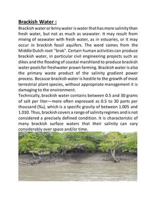
- 2. Mangrove Environment : A mangrove is a shrub or small tree that grows in coastal saline or brackish water. The term is also used for tropical coastal vegetation consisting of such species. Mangroves occur worldwide in the tropics and subtropics, mainly between latitudes 25° N and 25° S. The total mangrove forest area of the world in 2000 was 137,800 square kilometres (53,200 sq mi), spanning 118 countries and territories. Mangroves are salt tolerant trees, also called halophytes, and are adapted to life in harsh coastal conditions. They contain a complex salt filtration system and complex root system to cope with salt water immersion and wave action. They are adaptedto the low oxygen (anoxic) conditions of waterlogged mud. The word is used in at least three senses:most broadly to refer to the habitat and entire plant assemblage or mangal for which the terms mangrove forest biome, and mangrove swamp are also used, to refer to all trees and large shrubs in the mangrove swamp, and narrowly to refer to the mangrove family of plants, the Rhizophoraceae, or even more specifically just to mangrove trees of the genus Rhizophora. The mangrove biome, or mangal,is a distinctsaline woodlandor shrubland habitat characterized by depositional coastal environments, where fine sediments (often with high organic content) collect in areas protected from high-energy wave action. The saline conditions tolerated by various mangrove species range from brackish water, through pure seawater (3 to 4%), to water concentrated by evaporation to over twice the salinity of ocean seawater (up to 9%).
- 3. Mangrove forests are usually found in the tropical and sub- tropical riverbanks, estuaries and along the coastlines, adapting to anaerobic conditions of both salt and freshwater environment.A mangrove communityplaysanimportantrole to the stabilisation and maintenance of various closely linked ecosystems, such as seagrass, coralreef andmarine ecosystems. It represents a unique ecological niche and habitat for a variety of marine and terrestrial animals. The amount of organic matter produced by a mangrove community supports not only the mangrove ecosystem itself but also its related ecosystems. Apart from providing an important coastal habitat for many types of species, a mangrove forest forms a community which helps to stabilise river banks and coastlines. Mangroves export detritus and nutrients into nearby systems that form a complex food chain which in turn supports valuable near-shore fisheries. In general, the mangrove forest of Bangladesh is divided into three zones, namely the Sunderban (largest continuous single productive forest of the world with an area of 577,040 ha), the ChakariaSunderbanin Cox’s Bazar with an area of 8540 ha, and the planted coastal mangrove forests. The plantationof mangroves was introduced in the coastal area of Bangladesh in 1964 and is still carried out in the coastal belt of Cox’s Bazar, Chittagong, Barisal, Patuakhali and off-shore islands, and now covers an area of 100,000 ha. Small patches of mangroves are alsofoundalong the beltof nearlyallcoastalsub- districts. Different types of mangrove species dominate in different places of the coastal and estuarine areas of Bangladesh. Fishing within the mangroves is one of the major activities in the coastal area. Several species of fish are found;
- 4. common ones are mullet (Mugil spp.), marine catfish (Mystus spp.), seabass (Lates calcarifer) and black tiger shrimp (Penaeus monodon). Other species of shrimps are Metapenaeus monoceros, M. brevicornis, P. indicus and Macrobrachium rosenbergii. However, everexpanding traditionalculture of tiger shrimp has already led to the destruction of mangroves in Chakaria Sunderban, Moheskhali, Teknaf and Sonadia Island at the south-east coast of the country. In 2002-3, the destruction of mangroves for traditionalshrimp culture in the south-eastern area was much higher than the previous. The environmental damage and destruction of fishery resources is still unknown in those areas. The loss of mangrove wetland in Bangladeshduring the last 25 years is about 50-70%. Similarly, in Sri Lanka an 11- 65% andinThailanda12-25% losswere estimated .However, not all the blame for mangrove destruction lies in coastal aquaculture. Depending on the locality, the impact of the destructive uses is highly variable, though the scale of impact commonly found elsewhere is similar to that found in Bangladesh,i.e.from (in descendingorder) clearcut forfirewood and pool, conversion to agriculture (salt bed and aquaculture), conversion to humansettlement, and diversionof fresh wateror water quality changes.
- 5. CULTURE OPPORTUNITIES : Brackish water aquaculture is mostly practiced in low-lying tidal flood plains within Water Development Board (WDB) polders, that were originally constructed to reclaim land with potential suitability for agriculture. In many areas, e.g. in Rampal and several other upazila's in Bagerhat District, the private farmers have constructed light dykes along the river banks for dual purpose of agriculture and aquaculture. Only those areas that are low enough to permit at least 50 cm of inundation by spring tides throughout most of the year, are normally used for shrimp culture. Excavation of land for construction of brackish water shrimp farms is not in practice in Bangladesh. Pumping, to supply water from the surface or from sub-surface layers, is also not used for aquafarming. In some places (quite common in Paikgacha, Rampal, Pirojpur, Patuakhali, and elsewhere) many small domestic ponds are connected with tidal creeks; these ponds are used not only for domestic washing, but also for shrimp and fish culture with various degrees of intensity.
- 6. Species for culture: Several species of shrimp, crab and fish may naturally occur in the brackish water aqua farms. Only two genera of shrimp, Penaeus (mainly P. monodon) and Macrobrachium (mainly M. rosenbergii) are deliberately stocked in the farm ponds. P. monodon is by far the most desired culture species. M. rosenbergii is stocked only in areas of low salinity. Although spawning and larval development of M. rosenbergii occur in the brackish water region (10–15 ppt salinity), its further development normally takes place in freshwater. The species may also grow well in waters of low salinity. Metapenaeus monoceros, a rather small sized shrimp, is a welcome intruder because of its export quality; the species abundantly occurs in nature. P. indicus and P. merguensis occur in small quantities in the southwest zone of Bangladesh. They are also welcome in the farms; the two species may grow to a fairly large size and are well exportable. Metapenaeus brevicornis, a small shrimp, makes up a substantial contribution to the total production. This species was more or less considered a pest in the culture systems, but it has, of late, entered the export market to a limited extent. Amongst the fin fishes, mullets Liza and/or Mugil spp.) are the most desired genera; they are auto stocked. The young ones of these fishes are occasionally collected from the wild and stocked along with shrimp. During the low-saline period, starting with the onset of the monsoon, some farmers stock freshwater carp
- 7. (Bangladeshi and Chinese species) and/or tilapia (Oreochromis nilotica, O. mossambica). The most bothersome species of fish occurring in the culture systems include a number of predators, e.g., Lates calcarifer, Eleutheronema tetradactylum, Glossogobius giuris, and Mystus menoda.Mudskippers are also quite common. Congresox eels occur occasionally. Except for the eels, all other predator fish have high demand and command a good price in the local markets, but they can decrease the shrimp harvest substantially. Seed availability and collection : Species and numbers collected : Shrimp farming in Bangladesh still entirely depends on natural seed supply. P. monodon is the only salt water shrimp of which postlarvae are collected on commercial scale for stocking. It is estimated that the number of P. monodon postlarvae collected in 1985 was in the order of 1–3 billion. M. rosenbergii postlarvae and juveniles are collected in the Khulna region for stocking in freshwater ponds or in low salinity brackishwater shrimp farms. No estimates are available of the number of M. rosenbergii seed collected annually. Collection of mullet seed seems to be an occasional practice in the Satkhira and Khulna districts. Collection gear : Basically two types of seed collection gear are encountered: fixed and mobile. The fixed type is a bag net, locally called Behundi jal. The net is made of a synthetic material called velon. The screen has a P-24 quality (24 meshes per 2.5 cm lenght). About 15 m2 material is needed
- 8. for one net; two guide wings require extra material of the same quality. The cod end is generally made of second- hand synthetic cloth. The net is fixed near the shore with a bamboo pole and can be operated from the shore. Table 2 - Main collection centres for P. monodon District Rivers Satkhira Ichamoti, Golgasia, Kalindi, Kakshiali, Chunar, Chunkuri, Kholpetua, Malancha, Madar, Aiburi, Betna, Kapotakshi. Khulna Bhadra, Sibsa, Minhaj, Pussur, Kapotakshi, Koira, Deluti, Garaikhali. Bagerhat Mongla, Pussur, Daudkhali. Cox's Bazar Sea beach, Moiscal Channel. The mobile nets may be triangular or rectangular. They are made of bamboo or mangrove twig frames and P-24 velon screen. The gear is operated either by pushing or pulling. There is a clear scope for improvement of the existing seed collection gears to achieve more effective seed collection under varied environmental conditions, such as on the open sea beach, in tidal areas with mangrove bushes, in rivers with strong currents or floating trash, on the tidal flats, etc. Collection season : The seed collectors report that P. monodon seed occurs in the main collection centres throughout the year. In the Khulna region, the period February-May represents the
- 9. peak seed collection as well as pond stocking season. Later in the year the seed demand declines, since there will be not much time for stocked shrimp to grow to good grades before the monsoon starts freshening the pond and river waters. In the Cox's Bazar region the peak seed collection period is April-June. M. rosenbergii postlarvae are reported to be available in the Khulna region from April. Its demand peaks in July, when most of the P. monodon is generally harvested, the water salinity drops and the large farms are ready for stocking freshwater species Seed sorting : The seed collectors transfer their catch along with floating mangrove twigs, leaves, etc. to earthen bowls. A group of small children spreads the collection along with water in white enamelled flat plates and sorts out the P. monodon seed with plastic spoons or freshwater mussel shells, and throws away the rest of the shrimp postlarvae and fish fry on the shore. This leads to a collossal damage to the shrimp and fish resources every year. Detailed quantitative and qualitative analyses of the collections made during the seed collection efforts have never been attempted. Rough observations during field visits suggested, that P. monodon postlarvae constitute at the most one percent of the total collection; larvae and postlarvae of miscellaneous shrimp, crabs, mysids, fish, etc., make up the rest. If one percent of the collection counts 1–3 billion (estimated number of P. monodon postlarvae collected from the wild), the remaining 99 percent would count about 99–297 billion animals. This is an enormous number of organisms, having the potential of producing a
- 10. large quantity of much needed animal protein for human consumption. FARMING PRACTICE : General farming pattern : Combination of aquaculture with agriculture is the normal parctice in the southwest zone. The farming pattern basically is as follows: During the high salinity period (January-July): culture of marine and brackishwater shrimp and fish and harvesting of the marketable individuals. During the low salinity period (August-December): continuation of rearing of the undergrown shrimp and fish of euryhaline nature in the low-lying areas and ditches in the fields; culture of freshwater fish and shrimp together with the euryhaline brackishwater species; cultivation of a slightly salt-resistant transplanted Aman paddy in the elevated parts of the fields; harvesting of the residual shrimp and fish. Most of the shrimp culture activities are carried out in large dyked areas, called polders. They are locally known as Ghers, meaning earthen enclosures. The dyked brackishwater region is suitable normally for one crop of transplanted Aman paddyduring August-December, when the water and soil salinities are low. Agricultural crop production during January-July is difficult. The increase of the salt content of the top soil in the dry season caused by capillary rise of the saline ground water, limits the possibilities for cultivation of a second crop. Freshwater for irrigation is not available since both surface water and ground water are saline during the dry months.
- 11. There is still another problem: the soil is acidic in many places. When exposed to the sun, the soil acidity increases further, reducing soil productivity. Instead of keeping the land fallow during the high salinity period, many farmers find it rather profitable to utilize the low-lying and adequately submersible lands for fish and shrimp farming. Thus, many tidal flood plains are used for agriculture during the wet months and aquaculture during the dry months (rotation) Traditional culture techniques : By mid-December, cropping of paddy is normally completed. Harvesting of finfish and any residual stock of marine shrimp is also completed. Macrobrachium rosenbergii (if stocked at all) may still grow on to a sufficiently large size; the farmers would therefore prefer this shrimp to remain in the field. This can be done if there are suitable ditches or canals that can be used as sanctuaries. The field itself, along with the paddy stumps, is normally exposed to the sun until the beginning of February. Then the P. monodon seed appears in good numbers and the spring tides are high enough to adequately inundate the field. The total period of field drying varies from farm to farm and from place to place. Until recently, no screens were used in the sluice structures to prevent entry of predator animals into the farm. Screens to prevent escape of the autostocked animals were also not used, based on the belief that autostocked animals (and particularly P. monodon shrimp) would not leave the farm with the outgoing tide water before they have grown to a large size. Sometimes farmers did use coarse bamboo
- 12. screens in the drainage sluices to retain the stock, but the screens were too course to serve the purpose effectively. Selective stocking was unknown until rather recently. A few farmers started practizing supplementary stocking with P. monodon and M. rosenbergii postlarvae or juveniles. Seed collection was limited to Satkhira and Kaliganj areas. A nursery prctice was not followed. The concept of the need of liming, fertilization and artificial feeding to enhance shrimp production was still to be introduced. Unaware of the ecological needs of the shrimp, the farmers' concern was only to facilitate entry of as many shrimp seed as possible into the farm, and not to maintain the required physico- chemical qualities of the water. By using these traditional methods, with no or very little efforts for pond preparation, liming, fertilization, pest control, selective stocking, nursing, supplementaryfeeding,and water management, the shrimp production rate was low, probably not exceeding 50 kg/ha of P. monodon per year. Present Status of the Bangladesh Sundarbans : Physical and Chemical Environment: Climate: The SMF is situated in the warm, humid tropical region where mean annual minimum and maximum temperatures are 21 and 30 °C, respectively, mean annual relative humidity varies from 70% to 80% and annual rainfall varies from 1640 and 2000 mm. Hydrological regimes: Stream flow through Ganges, Bahmaputra and Surma-Kushiara Rivers. originating from the Himalayas is the largest component (about 90%) of freshwater sources in Bangladesh .The rivers flow generally from north to south. Out of 15.5 million km2 of catchments,Diversity 2015, 7
- 13. 247 only about 7.5% lie within Bangladesh and are distributed over most parts of the country Effect of Farakka Barrage on Salinity: Salinity increase in the BSMF occurred for two reasons: first, the diversion of freshwater at Farakka Barrage and second, by oceanic currents. The BSMF is now facing the two extremes. One immediate effect of the lower extreme is the increased salinity during the dry period. The salinity in the northern part of BSMF increased from 7.50‰ in 1968 to 12.50‰ in 1976 for March and to 18.50‰ in the month of May after two years of operation of the Farakka Barrage. Water: A direct relationship of the changed salinity (10.40‰ to 26.2‰ in March) with the TDS (8.03 to > 20 g/L) and conductivity (16.02 to 34.14 mS/cm) was found in different locations.Alkalinity ranged from 0.362 to 0.438 meq/L irrespective of salinity and tides. Similar is the case with pH that varied from 7.26 to 7.98. Tide: Depth and duration of tidal inundation is an important regulator of mangrove productivity. Tides help in mixing vertical water columns, thereby providing nutrients and enriching water, providing vertical motion to the groundwater table that may transport nutrients to the root zones of the mangroves, transporting oxygen to the root system, etc.Tidal waves vary in different regions of BSMF according to the different hydrodynamic characteristics of rivers and cross channels. Mean tide height in the monsoon is at its highest (2.00 to 2.86 m) and at its lowest (1.56 to 2.00 m) in the dry period. Soil: The forestland soil is grey in color, finely textured and the subsoil is stratified, compacted at greater depth. At the eastern part of the soil (having good supply of fresh sediments), the top
- 14. 15 cm soil layer is soft and fertile, whereas in the western part (with little fresh sediments), the soil is a hard mass . Na content of soils varies from 5.7 to 29.8 meq/100g, where the lower value is found in the eastern part. Mg varies from 4.1 to 9.9 meq/100g. Chloride is a dominant anion varying from 5.7 to 23.2 meq/100g, and the high concentration is found in the southern and western parts. Potassium content varies from 0.3 to 1.3 meq/100g. The high value of the Na and Mg hampers plant growth. Organic carbon and nitrogen are 0.62 and 0.05%, respectively. Organic matter ranges between 4% and 10%. Soils are neutral to mildly alkaline (6.5 to 8.0 pH). The pH in depressions with high organic matter ranges from 5.3 to 6.4 Floral Diversity: Vegetation of the BSMF: A total of 70 species from 34 families of the entire Sundarbans has been Reported. From the Bangladesh Sundarbans, 65 species (large trees 10, small trees 20, shrubs 25 and herbs 10 including two ferns) of 37 families have been reported .Recently, a total of 115 species have been recorded, where, in addition to more than 10 large trees, seven more (Avicennia marina, Bruguiera parviflora, B. sexangula, Ceriops candellana, C. roxburghiana, C. tagal, Rhizophora apiculata) are added including 10 species of sedges, five species of grasses, and many species from other groups. Phytoplankton: Phytoplankton communities consist of a total of 35 taxa including nano- and picoplankton, the number exceeds 50. Oocystis pussilla, a freshwater phytoplankton, was recorded as dominant under all salinity conditions.
- 15. Benthic algae: A total of 35 benthic algae have been recorded .Most spectacular are species of Catenella, Caloglossa, Bostrychia and Cladophorella growing on pneumatophores and on stems submerged during high tide; Enteromorpha intestinalis as a drifted form, while others grow on muddy forest floor. Threats to the Systems: Natural disasters and man made factors: Cyclonic storms and tidal surges severely affect the biotic communities of the coast by uprooting plants, eroding coastal soils, breaking stems and branches, human settlements and lives. During the 1988 cyclone, a total of 3,713,655 Heritiera fomes and 4,718,420 Sonneretia apetala were damaged .Some other natural disasters that affected the SMF include: flood and tidal surge in 1985, flood in 1987, cyclone in 1991, flood covering 75% of Bangladesh in 1998, floods in 2004 and 2007, cyclone Sidr in 2007, Cyclone Aila in 2009, cyclone Mahashen in 2013 destroying a large number of mangroves, and human settlements at the impact zone. Oil pollution: Mongla International Shipping Port has a harboring capacity of over 70 oceangoing ships at a time. Thus, effects of navigation and the possibility of oil slick to a certain extent is there, and authorities have taken measures (imposing fines) to reduce the chance of oil spills. Oil spills will affect many of the ecological systems. Amongst fungal populations, species of Aspergillus (75%) and Helminthosporium (about 25%) are involved in the process of decomposition .
- 16. Coal-fired power plant: The under construction plant at Rampal, about 14 km north of the BSMF, has planned to produce 1320 megawatts of electricity, and will require 13,000 metric tons of coal per day, releasing about 8 million tons of CO2, 0.75 million tons of fly ash and 0.2 million tons of bottom ash annually. Threats to carbon deposits: The growing stock (number of trees per ha) of the BSMF was reduced to less than 50% by the year 2000 Conservation : Sundarbans Impact Zone: A 15 to 20 km band to the north and east of the BSMF has been considered as an Ecologically Critical Area (Sundarbans Impact Zone) since 1999 under the Bangladesh Environment Conservation Act 1995. The act is dedicated to the protection and maintenance of biological diversity to achieve the long-term conservation of nature with associated ecosystem services and cultural value. The zone is surrounded by agricultural lands and human settlements and consists of 154 Unions and 17 Upazilas of Khulna, Satkhira,
- 17. Bagerhat, Pirojpur and Borguna districts having an estimated population of 3.5 million. They are also dependent on BSMF for fishing, harvesting honey, Nypa leaves, etc. A commercial logging ban is in place until 2015. There is no human encroachment inthe BSMF Sanctuaries: There are three wildlife sanctuaries facing the Bay of Bengal: the Sundarbans East established in 1960, Sundarbans South and Sundarbans West established in 1977 .Total area of the sanctuaries is 1397 km2. UNESCO declared these sanctuaries and the Sundarbans as Natural World Heritage Sites in 1997. Restricted fishing areas: There are over 210 species of fish in the BSMF, and 120 species are harvested. They are also used as feed for other aquatic animals. For conserving them, Bangladesh Forest Department identified 18 small rivers in all four ranges. In addition, measures for selective fishing and protection of brood areas have been undertaken National Forest Policy: Environmental policy for conservation and protection of forest resources including coastal and marine areas, through Ministry of Environment and Forests, GOB has been incorporated. To reduce global warming, “Reduced Emission from Deforestation and forest Degradation” (REDD+) as per the Copenhagen Accord, has been implemented Sundarbans, a natural wall: Recently, many of the cyclones that were supposed to strike Sundarbans changed their routes towards Chittagong, a phenomenon that is most likely due to buffering of the atmosphere around the Sundarban Mangrove Forests and other coastal forests, securing Bangladesh .The BSMF is also acting against global warming by storing over 56 million metric tons of carbon.
- 18. Conclusion : The Sundarbans is a deltaic mangrove forest having freshwater influence, formed about 7000 years ago by the deposition of sediments from the foothills of the Himalayas through the Ganges river system. However, the discharge of sediment-laden freshwater into the Bay of Bengal through the Bangladesh part of the Sundarbans Mangrove Forests (BSMF) has been reduced due to a diversion of water during the dry period from the Farakka Barrage in India since 1975. The BSMF receives a mean minimum monthly discharge of 0.00 to 170 m3·s−1 during the dry period when a minimum of 194.4 m3·s−1 freshwater discharge is needed to maintain a low saline condition inside the forests. The zero or very low discharge through the forests allows seawater intrusion deep inside the BSMF increasing salinity of water and soil. This affectsthe growth of Heritiera fomes (sundri), the tallest (at over 15 m) and most commercially important plant and also affecting growth and distribution of other mangroves and biota. The high salinity results increase in relatively low-priced plants Bruguiera sexangula, Excoecaria agallocha and Sonneratia apetala. The growing stock of 296 plants per ha in 1959 had been reduced to 144 by 1996. Trend analysis using “Table Curve 2D Programme,” reveals a decreased number of 109 plants by the year 2020.