
Recommended
Recommended
More Related Content
Similar to Open Data Policy in the Earth Sciences
Similar to Open Data Policy in the Earth Sciences (20)
Recently uploaded
Recently uploaded (20)
Open Data Policy in the Earth Sciences
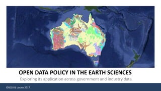
- 1. IDSE10 & Locate 2017 OPEN DATA POLICY IN THE EARTH SCIENCES Exploring its application across government and industry data
- 2. IDSE10 & Locate 2017 Value of Geoscientific Data “Explorers highly regard the accessibility and provision of pre-competitive data by Australia’s geological survey organisations.” Mineral and Energy Resource Exploration, Productivity Commission Inquiry Report no.65 “World-leading geoscience has been a key competitive advantage of Austalia’s exploration sector” www.minerals.org.au/policy_focus/exploration “Data on Australia’s landscape and climate has been collected for more than 100 years and this information can be used to inform national decisions about natural disasters, water, food, and resource management.” https://www.education.gov.au/unlocking-australia-s-geographic-time-machine “Understanding and analysing when and where things are happening is essential for government, industry and researchers to make decisions and improve national economic, environmental and social outcomes for the nation.” www.ga.gov.au/about/corporate-plan Value can not be measured in just $$$
- 3. IDSE10 & Locate 2017 Government Policy “Recognises intrinsic economic and social value of data. And that’s its value is exponential increase by sharing it, making it accessible with the appropriate considerations to commercial, privacy and security sensitivities” State Policies Accessibility of Data is key
- 4. IDSE10 & Locate 2017 Government Policy “Recognises intrinsic economic and social value of data. And that’s its value is exponential increase by sharing it, making it accessible with the appropriate considerations to commercial, privacy and security sensitivities” Where possible, ensure non-sensitive publically funded research data is made open for public use Make high-value data available for use by the public, industry and academia, in a manner that is enduring and frequently updated using high quality standards Engage openly with the States and Territories to share and integrate data to inform matters of importance to each jurisdiction and at the national level Ensure all new systems support discoverability, interoperability, data and information accessibility and cost-effective access to facilitate access to data State Policies Accessibility of Data is key
- 5. IDSE10 & Locate 2017 Geological Exploration Literature Review (Data collation) Regional selection Resource identification Area selection Regional Prospecting (Geophysical Survey) Feasibility Targeted Prospecting (Drilling) Epithermal deposits are typically high grade, small tonnage and relatively shallow deposits. Vast quantity and variability of data is produced
- 6. IDSE10 & Locate 2017 Role of Geological Surveys as Data Curators Long tradition • 140 years cumulative scientific inquiry • Geological Surveys since late 1800s Core business functions • Provide advice • Improve geological understanding • Store and delivery data Long shelf life • Old and new data • Observations • Measurements • Interpretations • Models Open systems • Non-proprietary • Data services Critical responsibility that requires resources
- 7. IDSE10 & Locate 2017 Research initiatives IndustryGovernment Geoscience Data Managed by State Geological Surveys Different resources/crossing sectors
- 8. IDSE10 & Locate 2017 Company reports Managed by State Geological Surveys Geological reports Environmental reportsAcceptable File formats Drilling data templates Mandated requirement
- 9. IDSE10 & Locate 2017 Value of Geoscientific Data Geoscience information is the currency of exploration $350,000 - $500 ,00011,000kmsq. $300,000 Airborne Geophysical Survey Diamond drilling 300m Examples of costs
- 10. IDSE10 & Locate 2017 Reporting Requirements & Data Standards National Mineral Exploration Data Submission Standards Government Geoscience Information Committee Mandatory metadata File naming conventions Acceptable formats for digital data Templates CoalLog Standard Collaboration btw mining companies, software companies funded by Australian Coal Industry Research program Data entry sheets Std codes lookup tables Transfer formats Useability & quality
- 11. IDSE10 & Locate 2017 Open Geoscience Benefits “Open data enables a situation where the collective genius of thousands of researchers produce insights and analyses, inventions and understanding beyond what isolated individuals with their silos of data can product” Sir Nigel Shadbolt Chairman and Co-Founder Open Data institute , State of Open Data report Completeness Scale (detail) Reduced duplication Quality Focus on advancement Pursuit of innovation Simplification of accessRepurposing
- 12. IDSE10 & Locate 2017 Open Geoscience Data Challenges Rules of access / confidentiality – eg as applied to exploration reports Commercial in confidence. A classification that identifies information that, if disclosed, may result in damage to a party's commercial interests, intellectual property or trade secrets. Intellectual property (IP) is the property of your mind or proprietary knowledge. It is a productive new idea you create. This can be an invention, trade mark, design, brand or even the application of your idea Copyright provides legal protection for people who express ideas and information in certain forms. The most common forms are writing, visual images, music and moving images.
- 13. IDSE10 & Locate 2017 Australia geology overlaid Google Maps services : http://portal.geoscience.gov.au/gmap.html Photo mosaic : Australian Open Data Policy Statement www.dpmc.gov.au/sites/default/files/publications/aust_govt_public_data_policy_statement_1.pdf Cross section image: http://daciangold.com.au/overview/westralia/ Epithermal diagram : www.geologyforinvestors.com/epithermal-gold-deposits/ Australia’s geology and geophysicalimagery overlaid Google Maps services : http://portal.geoscience.gov.au/gmap.html Others :Geological Survey NSW Images and diagram credits