
Recommended
More Related Content
What's hot
What's hot (20)
Similar to human settlament and town planning
Similar to human settlament and town planning (20)
More from SrujanaReddy41
Recently uploaded
Recently uploaded (20)
human settlament and town planning
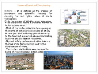
- 1. Human settlement and Town planning PLANNING — It is defined as the process of systematic and scientific thinking for choosing the best option before it starts taking place. •It is the process of thinking about tomorrow. •The evolution of towns in a planned manner in indian subcontinent. •Most of the early civilization have sprung on the banks of some navigable rivers or at any natural port which not only provide security to the town but also acted as a communicating link from one civilization to another. •Physical safety and communication links are the two prime factors which lead to the development of towns. •The earliest civilizations were seen on the banks of rivers like NILE, GANGA, SINDHU.
- 2. IRREGULAR LAYOUT irregular pattern in planning was devised to confuse enemies; as enemies unfamiliar with town. open spaces, streets, plazas developed as an integral part of site. streets were used for pedestrian while wheels were restricted to main roads planning the city of middle ages grew within the confines of the walls. CARCASSONNE It contains market square, castle & church of St.Nazzair. Irregular pattern for streets is seen.
- 3. GRID PLAN •The grid plan, grid street plan, or gridiron plan is a type of city plan in which streets run at right angles to each other, forming a grid. •The infrastructure cost for regular grid patterns is generally higher than for patterns with discontinuous streets. • Cities like: Chandigarh, New York City, Savannah, Tokyo, Barcelona, and Back Bay Boston CHANDIGARH •CHANDIGARH is a city and a UNION TERRITORY in the northern part of india that serves as the capital of the states of PUNJAB and HARYANA. •LE Corbusier conceived the master plan of Chandigarh as analogous to human body, with a clearly defined • • • HEAD (the capitol complex, sector 1) • • HEART (the city Centre sector-17) • • LUNGS (the leisure valley, innumerable open spaces and sector greens) • • INTELLECT (the cultural and educational institutions), • • CIRCULATORY SYSTEM (the network of roads, the 7Vs) • • VISCERA (the industrial area).
- 4. RADIAL CITY PLANNING Features of radial city pattern •Inner outer ring roads linked by radiating roads. • Core has the business area. • Industrial area interspersed within the residential. • Periphery has green belts. Washington DC •The District of Columbia the capital of the United States. It is located between Virginia and Maryland on the Potomac River. •The district is named after Columbus. • DC history began in 1790 when Congress directed selection of a new capital site, 100 sq mi, along the Potomac. •When the site was determined, it included 30.75 sq mi on the Virginia side of the river. •The city was planned and partly laid out by Maj. Pierre Charles L'Enfant, a French engineer. •This work was perfected and completed by Maj. Andrew Ellicott and Benjamin Banneker, a freeborn black man who was an astronomer and mathematician. I •n 1814, during the War of 1812, a British force burned
- 5. Presented by: YEDAPALLY SRUJANA 18031AA079 B- SECTION 6TH SEMESTER