DEM FAQ
- 1. Copyright ©2014 The Center for Earth Observation, Yale University http://www.yale.edu/ceo Page 1
Digital Elevation Model (DEM) Data
Digital elevation data can now be obtained for any place on the Earth, at several resolutions. This
document will discuss the major sources for reliable and freely available DEM data in addition to
the steps for obtaining the data for personal use.
In order to choose the right source for DEM data, there are two main criteria to consider:
geographical region of interest and spatial resolution. Below is a table that summarizes the DEM
data sources that are discussed in this document.
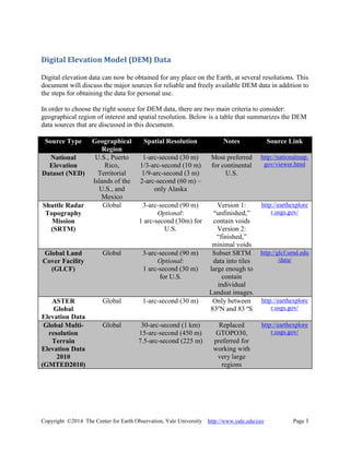
Source Type Geographical
Region
Spatial Resolution Notes Source Link
National
Elevation
Dataset (NED)
U.S., Puerto
Rico,
Territorial
Islands of the
U.S., and
Mexico
1-arc-second (30 m)
1/3-arc-second (10 m)
1/9-arc-second (3 m)
2-arc-second (60 m) –
only Alaska
Most preferred
for continental
U.S.
http://nationalmap.
gov/viewer.html
Shuttle Radar
Topography
Mission
(SRTM)
Global 3-arc-second (90 m)
Optional:
1 arc-second (30m) for
U.S.
Version 1:
“unfinished,”
contain voids
Version 2:
“finished,”
minimal voids
http://earthexplore
r.usgs.gov/
Global Land
Cover Facility
(GLCF)
Global 3-arc-second (90 m)
Optional:
1 arc-second (30 m)
for U.S.
Subset SRTM
data into tiles
large enough to
contain
individual
Landsat images.
http://glcf.umd.edu
/data/
ASTER
Global
Elevation Data
Global 1-arc-second (30 m) Only between
83ºN and 83 ºS
http://earthexplore
r.usgs.gov/
Global Multi-
resolution
Terrain
Elevation Data
2010
(GMTED2010)
Global 30-arc-second (1 km)
15-arc-second (450 m)
7.5-arc-second (225 m)
Replaced
GTOPO30,
preferred for
working with
very large
regions
http://earthexplore
r.usgs.gov/
- 2. Copyright ©2014 The Center for Earth Observation, Yale University http://www.yale.edu/ceo Page 2
National Elevation Data – NED – US Only
The National Map is the primary source of the National Elevation Dataset (NED) data of the
U.S. at: http://nationalmap.gov/viewer.html.. When you first visit this site you should read the
directions for downloading data from the National Map Viewer before searching for data. This
will teach you to easily navigate the site and select exactly what you need. These data have a
Geographic “projection” (latitude/longitude) and use the NAD83 datum. You will notice that
there are many other types of data available at this site, which are not covered in this document.
Within the U.S. you can access NED data at 1 arc second (~30 m), 1/3-arc-second (~10 m), or
very occasionally 1/9-arc-second (~3m) resolution. For Alaska, the NED data are primarily 2-
arc-second (~60 meters). All of the data are prepackaged in 1x1 degree tiles, except for 1/9 arc
second data that are prepackaged in 15x15 minute tiles.
Using the interface, zoom in on the area of interest. Click on the Download Data button in the
right upper corner. There are few options for defining your region of interest by: drawing a
rectangle, selecting a reference area, adjusting current map extent, and entering coordinate input.
Reminder: the data is available for only North America (U.S., some Canada, and Mexico).
Next specify the type of data you would like to download, e.g. Elevation. If a certain checkbox is
disabled or an error notification box appears, then zoom in for finer spatial resolution.
Different output formats are available on the National Map Viewer: IMG, ArcGrid, and
GridFloat. You should choose the IMG format if working with ENVI.
Add the product you are most interested in to the cart. Check out by providing your email
address. The link (or multiple links depending on the size of the region) to download the data
will be sent immediately to the email address.
MRLC
The Multi-Resolution Land Characteristics (MRLC) Viewer at http://www.mrlc.gov/viewerjs/ is
an alternative site to obtain DEM data for the continental U.S. Select Data | Download Tool |
Elevation to specify which spatial resolution you need. Then, specify the region of interest by
defining a rectangular area or entering coordinate information.
Once you have selected the type of data you wish to obtain and the region you want, use the
“Define Download Area” tool to select the data. Your data request will be processed and in a
short time the SDDS Request Summary Page will open. Depending on the size of your area, you
will have one or more tiles listed for each product selected. The size in megabytes and output
format are also displayed in this window.
Warning! The default download data format is ArcGrid. This format is native to ESRI GIS
products and is difficult to work with in most remote sensing programs. GeoTIFF, BIL, and
GridFloat formats are also available. We strongly recommend that you select GeoTIFF as
- 3. Copyright ©2014 The Center for Earth Observation, Yale University http://www.yale.edu/ceo Page 3
follows: Click on the “Modify Data Request” button to select GeoTIFF. You also have the
choice of two compression formats. You should accept the default ZIP format.
Shuttle Radar Topography Mission – SRTM
In February of 2000 the Space Shuttle mapped most of the land surfaces of the Earth to create a
high resolution elevation dataset. Global data were released at a 3-arc-second (90 m) resolution.
Data covering the United States were also released at a 1-arc-second (30 m) resolution.
NASA has completed its second release, Version 2, of the SRTM data. These "finished" data
have most voids filled in, lake surfaces have been corrected, and coastlines have been properly
defined and aligned. These data are available at the USGS Earth Explorer site. Data are
available at 3-arc-second (90 m) resolution globally, and also at 1-arc-second (30 m) in the U.S.
Care should be taken when using SRTM data in areas with extreme topographical change as
there are still data voids in some of these areas.
You will first select a location by: entering coordinates, path/row information, or address/place
name; or creating feature polygons by clicking directly on the map. Next, you select the type of
data, which in this case will be SRTM under Elevation. There are three types of SRTM data:
SRTM, SRTM Void Filled, and SRTM Water Body Data. If you are looking for elevation of
water bodies, then you should choose SRTM Water Body Data. Otherwise, if you are looking at
land elevation, you should choose SRTM Void Filled (Version 2) since SRTM (Version 1) has
too many voids. After submitting the request, the results will be packaged in one degree tiles and
available for immediate download. You can click on the (Show Browse Overlay) button in
the results section to display the SRTM tiles on the interactive map. You have a choice of three
formats for download: GeoTIFF, DTED, or BIL. When using these data with ENVI, you should
always select the GeoTIFF format.
Global Land Cover Facility –an SRTM source by Landsat Path/Row Tile
The earth science center at the University of Maryland also distributes SRTM data, conveniently
subset into tiles large enough to contain individual Landsat images. These are distributed in
GeoTIFF format and can be used with any program designed to use spatial data. The Global
Land Cover Facility provides the following elevation data at these resolution scales:
1-arc-second (30 meters) “Unfinished” SRTM data of the continental U.S.
3-arc-second (90 meters) “Filled Finished” SRTM data of the world
30-arc-second (1 kilometer) “Unfinished” SRTM-GTOPO30 of the world.
(For large regions using the 1km data see the GMTED2010 section below)
- 4. Copyright ©2014 The Center for Earth Observation, Yale University http://www.yale.edu/ceo Page 4
(Source: GLCF, University of Maryland)
The “Filled” data are produced from the Version 2 finished data and have an interpolation
algorithm applied to fill in the data voids. You should always select a “Filled Finished” version
when available. Within the U.S., you can also download 1-arc-second (30 meters) data, but these
data may only be available in the “Unfinished” format. For continental U.S.1-arc-second data,
you should use the NED site described above.
SRTM one degree tiles at both Version 1 and 2 processing levels can still be obtained at the
NASA SRTM FTP site. These data are organized by version, then continent. Individual tiles are
labeled by the latitude and longitude of the lower left corner of the tile.
ASTER Global Elevation Data
The science teams at the NASA Jet Propulsion Lab (JPL) and Japan’s Ministry of Economy,
Trade, and Industry (METI) used the ASTER sensor onboard the Terra satellite to produce 30 m
resolution elevation data. These data cover 99% of the land surface from 83 degrees north
latitude to 83 degrees south latitude. Version 2 of these data was released in October 2011 and is
a significant improvement over the initial data release. You can view the latest information
about these data at the USGS LP DAAC
- 5. Copyright ©2014 The Center for Earth Observation, Yale University http://www.yale.edu/ceo Page 5
These ASTER data are now available at the USGS Earth Explorer site. You may zoom in, create
polygon features, or enter path/row information to select your area of interest. Then select
elevation data set, after which you would need to select the appropriate results to add to your
“shopping cart.” You will receive an email when the data are available for retrieval.
Global Multi-resolution Terrain Elevation Data - GMTED2010
The USGS has global DEM data at several resolution levels: 30-arc-second (1 kilometer), 15-
arc-second (450 meters), and 7.5-arc-second (225 meters). The GMTED2010 dataset with
multiple resolution levels replaces a former version called GTOPO30, which only had the
resolution level of 30-arc-second (1 kilometer). These data have been collected from a variety of
sources using aggregation methods. These datasets are best used for working at the continental
scale and with very large regions. More information is available at the USGS pubs site. The data
can be accessed via the Earth Explorer site.
A copy of the global 30-arc-second (1 kilometer) GMTED2010 data has been downloaded for
internal use to a server at the Yale Center for Earth Observation (YCEO). Please see a member
of the YCEO staff for guidance in using these data.