SlideShare a Scribd company logo
1 of 23
Download to read offline
2013 photo
Dr	
  Bob	
  Williams’	
  ODYSSEY	


Part of the journey of a surveyor and cartographer
1966 -2014
Research and Development Proposal - Gi 2000
REGIONAL GEOSPATIAL INFORMATION AND SERVICES
(ReGIS)1
Robert J. Williams
DSTO PAPER
2
16 December 1994 1994
The purpose of the proposal - termed Project gi 2000 - is to offer a strategy
and a commitment to an evolutionary approach in the development of
system to provide Regional Geospatial Information and Services (ReGIS).
1 This paper has been re-typed and illustrations redrawn.
2 DSTO PAPER,
Note: The paper had a low level security classification. The paper had distribution limited to
Defence personnel. The paper was a discussion paper and NOT published as a DSTO
Report.
2
BACKGROUND
1993
At the 20th Steering Committee Meeting of the Digital Geographic Information
Working Group hosted by Spain's Ministerio de Defensa Segente and held at Servicio
Geografico del Ejercito in Madrid the United States member provided an Update on
Product Developments. An addition to the DMA (Defense Mapping Agency) system is
G2IS. "Global Geospatial Information and Services (G2IS) is worldwide precise
spatially co-referenced information about the earth, arranged in a coherent structure
to support measurement, mapping, monitoring, modeling, terrain evaluation, and
spatial reasoning applications. Information may be tiled (geographically partitioned)
and / or thematically layered and will be compatible with standard geographic
information system (GIS) packages for ease of export, manipulation, update, and
value-adding"3
.
1994
US Defense Mapping Agency DMA) - Headquarters 4
DMA HQ hosted a meeting at their Headquarters building on Monday 21 November.
It was arranged by Mr Charles Hall, Deputy Director (International Operations).
Topics included:
• Welcome and introduction by Mr Hall followed by discussions with COL (Dr)
Rich Johnson and Mr Hall on research topics including DMA's
interoperability vision.
• Visit to TASC (a private research organisation) with demonstration and
briefing of GGIS (Geospatial Information and Services) project by Mr William
MacDonald of DMA Systems Center, Mr Hall and scientists from TASC5
.
• Demonstration and briefing at the Warrior Support Center, including MUSE
(Mapping, charting and geodesy Utility Software Environment).
• Further discussions with COL Johnson on long term research issues.
The Global Geospatial Information and Services Initiative. In this current 'age of
automation', the US Defense Mapping Agency (DMA) is taking positive steps toward
supporting current and future mapping, charting, geodetic, and imagery requirements
for products, information and services. DMA is committed to continually improve
responsiveness to its users and to increasing its capability to satisfy a variety of
3 Refer to Report on a Visit to the United Kingdom and Spain, May 1993.
4 Refer to Report on a Visit to the United States of America and Canada, November 1994.
5 DMA, being a large organisation, has research and development done by a number of
organisations (including their own Systems Center). In 'informal' discussions, it was indicated
that they do not have a 'dependence' on the service laboratories and suggested that there is a
trend to use private research laboratories (such as TASC). As background information, the
'Earth Observation Magazine' (October 1994) reports that "TASC (The Analytic Sciences
Corp) has been chosen as a lead subcontractor on a Raytheon-led team to develop an
environmental surveillance and air traffic control system for the Amazon region. The potential
five-year contract is valued at more than US$1 billion, which TASC's share expected to be as
much as US$70 million. TASC will provide information technology for environmental
surveillance and weather data processing".
3
anticipated digital information requirements. These efforts are embodied in the
Global Geospatial Information and Services (GGIS) initiative.
GGIS is a commitment to information production, information management,
information dissemination and information servicing through fostering and
developing standards, providing technical and administrative support, and
developing and certifying software tools for use with global geospatial information.
GGIS encompasses current production and distribution and is very much a part of the
organisational change and digital production modification of the Agency. Full
implementation of GGIS is an evolutionary process that has already started. GGIS is
not a system that will come on line in the future; fully matured, GGIS is the way DMA
will do business in the future. The emphasis will be on providing and servicing global,
geospatial information instead of standard products. That information will be timely,
capable of being tailored, and user accessible in the GGIS distributed 'data
warehouse'.
The concept of Global Geospatial Information and Services (GGIS) is the most
revolutionary change in the provision and use of geographic information for many
decades. Up until now, digital products have, in most cases, been digital
representations of traditional products, such as maps. GGIS offers a managed
evolutionary path to electronic distribution of information and services, as well as
effectively addressing interoperability issues. The vision, and the road map to achieve
it, will facilitate joint interoperability for the Command, Control, Communications
and Intelligence (C4I) community.
Because this initiative has the potential of impact future ADF systems (either
directly or indirectly), a copy of a paper by Roberta Lenczowski has been included
for all addressees. It is vitally important that the ADO monitor this initiative.
INTRODUCTION
The Defence Force has been intimately involved over a number of years in
programs to map and chart our own country, its sea and air approaches as
well as being involved in cooperative ventures with several neighbouring
countries to map their areas of interest. In more recent times these efforts
have been directed to acquiring this information in digital form, making its use
much more flexible and expanding the opportunities for military exploitation.
Several Defence organisations have been actively acquiring databases of
infrastructure information with geographic descriptors for both strategic
planning and tactical use. Handbooks of geographic information have been
produced of several areas for military use.
Increasingly, a great deal of interest is being shown by the military in the
development of digital terrain models, terrain analysis products, digital
hydrography, air chart products in digital form, the use of graphics in
command and control systems, and applications of remotely sensed images
from satellite and aircraft mounted systems.
Within the civilian community the potential of computer based coordinated
land management systems is being exploited and the systems developed
4
incorporate much of the technology that is available for the collection,
collation, and distribution of synthesised land related data. These systems are
providing regional data bases, much of which has potential for military use.
The need to acquire, manage, distribute and use geographic information has
been emphasised in policy documents for many years.
POLICY GUIDANCE
Dr (now Prof) Paul Dibb in his Review of Australia's Defence Capabilities
(March 1986) observed that "the foremost peacetime defence requirement is
reliable and comprehensive intelligence about our own strategic environment".
The White Paper - The Defence of Australia, 1987 (prefaced by the
Hon.K.C.Beazley) - further endorses the belief noting that "the availability of
comprehensive and up-to-date maps and charts, together with a detailed
knowledge of the environment and its infrastructure, is fundamental to the
effective control of military operations".
Australia's Strategic Planning in the 1990s (prefaced by the Hon. Robert Ray)
notes that "there are two principle factors that underpin Australia's strategic
situation. These are the enduring features of our geography and location, and
the reality of political, social and economic change within the countries around
us".
Strategic Review 1993 (prefaced by the Hon. Robert Ray) is part of a
continuous cycle of defence planning documents and emphasises "the
importance that the Government attaches to enhancing our security in and
with the region".
The planning document notes that "the enduring nature of our land, sea and
air environment provides the long-term basis for our defence planning.
Australia's geography continues therefore to be a central factor in deciding the
characteristics of our military forces and our strategic concepts for their use".
The Review stresses that "intelligence collection and evaluation are
necessary to monitor regional developments, develop intelligence databases,
provide information on specific regional crises, and support ADF operations.
By providing a picture of the strategic environment, intelligence provides a
basis for planning and force structure development".
Furthermore, it notes that "a key measure of the effectiveness of the national
intelligence system is how well it can support both national security policies
and ADF operations. Systems are needed to fuse strategic and tactical
intelligence, gathered from a variety of sources, into a usable format for
commanders, eg through the development of distributed information systems".
As a result of these high level directives there is now a trend to give
geographic intelligence collection and analysis the highest priority, particularly
5
in a time of reduced likelihood of hostility. But what constitutes military
geographic information and where is the area of defence military interest?
MILITARY GEOGRAPHIC INFORMATION (MGI)
Detailed knowledge of the terrain, hydrography, airspace, climate and
infrastructure of Australia's area of likely military operations has the potential
to be a significant force multiplier in any future conflict in our region (Figure 1).
Figure 1: MGI categories
MGI categories
Military geographic information can be considered to be a part of the overall
requirement for intelligence by the military, along with strategic and economic
intelligence to assess the intentions of potential enemies and intelligence
about an enemy's capabilities and equipment. The geographic information
requirement can broadly be divided into three areas, namely:
• Infrastructure information. Infrastructure is a substructure or
underlying foundation on which the continuance and growth of a
community, state and country depends. Infrastructure includes man-
made structures and facilities, such as roads, schools, power plants,
transportation and communication systems, and their locations. This
group can logically be sub-divided into a number of themes; one such
arrangement being administration and institution, population and
habitation, road infrastructure, rail infrastructure, air infrastructure, sea
infrastructure, telecommunications, power and fuel, water resources,
Geology and soils
Land ownership
Natural vegetation
Environmental
data
Population
Road infrastructureTopography
Hydrography
Bathymetry
Port facilities
Airport facilities
Utilities (Power and water)
6
industry and commerce, health and medical, and recreational themes.
• Terrain intelligence which is primarily concerned with the natural
features of the terrain, and includes themes related to physiography,
hydrography and oceanography.
• Environmental data. This grouping includes characteristics pertaining
to the environment which, at this point in the evolution of geographic
databases, have been largely ignored. This grouping could include
details describing the atmosphere, climates, weather conditions and so
on.
Data representation
When considering defence requirements for geographic information, the
knowledge of terrain and its impact on military operations is viewed as
fundamental. The terrain is not only the land surface but the natural and man-
made features on or beneath the surface; features which can be described
with attributes pertinent in assessing the conduct of battle. The defence force
therefore requires knowledge about the terrain in one or more of the following
forms:
• in descriptive form such as a map or display where the image is clear
and unambiguous to the human eye;
• as discrete positional data, where the relationship established between
two points or a number of points is unambiguous, as in navigation
systems and elevation models;
• as relational terrain data, enabling its analysis and evaluation with
other data pertinent to the conduct of military operations.
Areas of application
The emerging applications for the use of digital geographic information (often
termed geospatial information) can be summarised as:
• Navigation and guidance. The requirement is for positional data and
map displays which support the navigation of an air or ground vehicle
or sea vessel and which is linked to the integral system of the vehicle
which may include terrain referenced navigation systems.
• Surveillance, targeting and weapons. The requirement is for terrain
data to support surveillance of the battlefield for the acquisition of
targets. Terrain data is also required in planning and siting of some
weapon systems.
• Command, control and communications. The state of the art in
information technology itself is driving this requirement for army and air
force command and control systems. The need extends from simple
background map displays to the sophistication of terrain analysis
databases.
7
Figure 2: MGI areas of application
Military functions
The scope of military functions include:
• Strategic analysis of potential enemy capabilities and intentions;
• Contingency planning;
• Logistic planning;
• Operational planning;
• Tactical operations on the ground, in the air and on and below the sea
surface;
• Training; and
• Force structure and equipment capability definition.
PROPOSED PROJECT
It has become increasingly obvious that in order to achieve effective and
efficient operation of defence systems in performing the military functions,
geospatial information must be readily available to the operational systems.
The purpose of this proposal - termed Project gi 2000 - is to offer a strategy
and a commitment to an evolutionary approach in the development of system
to provide Regional Geospatial Information and Services (ReGIS). This
project logically follows, and responds to recommendations to, previous
defence studies and plans, notably 'Defence Geographic Information
Command Information Requirements Consultancy' and 'Australian Defence
Force Military Geographic Information Development Plan'.
Navigation and guidance
Intelligence
Surveillance
Command, control and communications
Targeting and weapons
8
Vision
The Australian Defence Organisation will have the Defence component of a
National Spatial Data Infrastructure and accredited analytical tools to utilise
the geospatial information for analysis, presentation, modelling, planning,
rehearsal and operation consistently across operational units.
Mission
The mission is to provide scientific leadership in the development of advanced
models and analytical tools for geospatial data, and to actively promote
technological developments through committees, seminars, conferences and
the like to ensure 'real outcomes' on the investment in the research, both to
the Australian Defence Organisation and to Australia in general.
The objectives are:
• Spatial data infrastructure. To promote, foster and participate in the
design of the Defence component of a National Geospatial Data
Clearinghouse.
• Standards. To provide standards and guidelines necessary to enable
effective use and integration of geospatial information.
• Organisational framework. To strengthen the organisation and
management structures involved in the management and use of
geospatial information.
• Education and training. To actively encourage and involve academia
through collaborative activities.
• Industry involvement. To actively encourage and involve industry
through collaborative activities, and to facilitate technology transfer to
commercial organisations.
These objectives comprise a radically different conceptual approach to the
management and use of military geographic information. This approach
essentially consists of two key components: the generation and management
of geospatial information; and the supply and distribution of services.
Placed into a regional context, the capability might be termed Regional
Geospatial Information and Services (ReGIS). Therefore the goals are to:
• Design;
• Prototype;
• Conduct a pilot project; and
• Facilitate the implementation of ReGIS.
9
ReGIS
Concept
Expanding on the components, the overall concept comprises an integration
of modules designed to acquire, maintain and distribute thematic information;
to construct and distribute standard products; and to provide user services
and training (Figure 3).
Figure 3: ReGIS concept
Regional Geospatial Database. As an example only, it seems that we need
to design and develop a multi-level database which could become the
Defence component of a National Spatial Data Infrastructure. This model
could include four levels:
• Level 0 - Strategic level. The scale range for strategic level enquiries
ranges from 1:400000 through to smaller scales as required by
decision support applications. The area of coverage of this database
would extend over the entire world with access optimised for the Area
of Defence Military Interest, including Australia, South-East Asia and
the South-West Pacific.
• Level 1 - Operational level. The scale range for operational level
enquiries includes scale ranges from 1:80000 through to 1:400000 as
10
required by applicable decision support applications. The area of
coverage of this database would extend over the entire world with
access optimised for the Area of Defence Military Interest, including
Australia, South-East Asia and the South-West Pacific and, generally,
along the transportation and communication lines and places having
significant infrastructure facilities.
• Level 2 - Tactical level. The scale range for tactical level enquiries
includes scale ranges from 1:20000 through to 1:80000 as required by
tactical decision support application including area studies, terrain
analysis, infrastructure directories and background display.
• Level 3 - Urban level. The scale range for urban / facilities level
enquiries includes scale ranges from 1:5000 through to 1:20000 as
required by applicable decision support applications, urban and
cantonment information systems, terrain analysis, facilities
management and impact assessment. This level requires the
information content to meet the resolution and accuracy needs of urban
maps, facilities maps, terrain analysis products, and infrastructure
directories.
The information content needs to be organised into a set of generic themes as
described previously. The information needs to be feature coded and
appropriately described through the use of attribute tables to meet the
requirements in the aeronautical, topographic, hydrographic and
environmental domains. In addition the information needs to be periodically
revised and maintained.
Products and services
As an example only, it seems that we need to design and develop a range of
products and services. Initially, the products would include those based on
datasets being developed by the Digital Geographic Information Working
Group (DGIWG). Those currently being developed include:
• Background Display. The requirements for the Background Display
Dataset (BDD) are those features and attributes needed for display of
geographic information as a background for overlay of other typically
non-geographic information in command and control systems, mission
planning systems, and so on. The Digital Chart of the World (DCW)
fulfils the requirements for the base level of this dataset.
• Toponymic Data. The requirements for the Toponymic Dataset are to
provide a digital list of geographic place names and associated support
information to be used both as a standalone dataset and in conjunction
with other datasets.
• Transport and Logistics Planning. The requirements for the
Transport and Logistics Dataset (TLD) are those features and attributes
to support logistics planning and movement of personnel and materiel.
It is intended to provide detailed information on transportation routes,
11
such as roads, railroads, canals and navigable waterways, air facilities,
maritime ports, and so on, and may be combined with user supplied
data to support additional logistics planning requirements.
• Terrain Analysis. The requirements for the Terrain Analysis Dataset
(TAD) are those features and attributes needed to perform traditional
military terrain analysis, including cross-country movement, line of sight
and range and bearing calculations. TAD is actually a combination of
several datasets - Background Display Data or GEOMAP, Digital
Nautical Chart (DNC) and Digital Terrain Elevation Data (DTED).
• Air Information. The requirements for the Air Information Dataset
(AID) are to provide a graphic database of airspace structures and
vertical obstructions on the terrain for low to very low altitude, Visual
Flight Rules (VFR), and Instrument Flight Rules (IFR) for flight
operation and planning use. AID comprises two subsets distributed
separately: the AID-Aeronautical Information Subset (AID-Aero) and
the AID-Obstruction Information Subset (AID-Obs). AID-Aero will
contain all aeronautical information portrayed both on NATO
designated aeronautical charts and on ICAO charts, particularly
EnRoute Charts. AID-Obs will contain selected geographical features
required for safety and reference in low to very low air navigation.
The services could also include electronic queries, such as spatial analysis;
as well as access to catalogues of available information, spatial data expertise
and training.
Of fundamental importance in the provision of analysis is the use of certified
applications and tools. Research needs to be done to identify processes
useful for browsing, planning systems, decision support systems, and
operational command and control systems.
The long-term goal is to establish a user accessible data warehouse.
EVOLUTIONARY DEVELOPMENT
A report prepared by the Directorate of Operational Information Systems,
Force Development (Joint) Branch in 1994 identified in excess of thirty
projects in various stages of development and acquisition, while a study
sponsored by the same branch in 1993 identified hundreds of separate
groups and units that use military geographic information. Although DI(G)
ADMIN 05-1 The Force Development Process requires that dependencies of
a project on geographic information be identified in Part 2 of the project's
Major Capability Submission, few, if any, have done so.
In addition, the requirements for routine data collection and production of both
standard and non-standard geographic products will be driven by assessment
of the following:
12
• Strategic guidance;
• Operational concepts;
• Endorsed contingency plans and Australian Joint Service Plans;
• Training requirements to meet CDF Preparedness Directives; and
• Maritime requirements.
Again, little to no effort has been put into translating these requirements into a
strategy of the collection, management and distribution of geospatial
information.
As such, it is proposed that research and development follow a model of
evolutionary development as shown in Figure 4 and include the following
stages:
Near Term (1995). In response to these deficiencies, the immediate tasks
need to address as a minimum:
• the transfer of technology to Project Directors by way of advice on
geospatial technologies and implications to their respective projects.
(This process has been managed in a somewhat informal manner to
date; the exception being the Mine Warfare System Centre Project
where DSTO has had formal tasks in place for a couple of years.)
• the determination of Geospatial Information Requirements for Defence
decision support, command and control, surveillance and intelligence
systems through a formal analysis of policy and planning documents
and system capability proposals.
• assessment of academia and industry expertise in the management
and use of geospatial information.
• detailed design of the full scope of this Project to the year 2000.
Mid Term (1995-97). As a result of the near term activities, it will be possible
to address issues in a methodical manner. It is anticipated that issues will
include:
• initial design of the Defence component of the National Spatial Data
Infrastructure clearinghouse.
• design and development of an electronic catalogue of information and
services.
• determination of procedures to facilitate certification of geospatial data,
algorithms and processes.
• design and development of advanced geospatial data models,
specifically for infrastructure (airports, ports, etc) and environmental
information, such as that concerned with oceanography and the land-
sea-air interfaces.
Objective (By 2000). It is envisioned that the following will be achieved:
13
• infological and datalogical studies will be complete enabling the design
of a ReGIS data warehouse.
• development of an accredited geospatial data model to define our
environment and its infrastructure.
• development of accredited 'intelligent' spatial querying tools.
• development of techniques for mission planning and rehearsal.
Figure 4: Evolutionary development
Benefits of the ReGIS concept
The benefits of implementing a system for Regional Geospatial Information
and Services promise to be quite substantial and can be summarised as:
ReGIS Information. It is envisioned that the information will:
• Provide regional, accurate, precise and current spatially coreferenced
information about the area of defence military interest.
• Use standard data exchange formats to ensure geospatial
interoperability for command support systems, mission planning
systems, navigation systems, and so on.
14
• Support measurement, mapping, visualisation, monitoring, modelling,
terrain evaluation, and spatial reasoning applications.
• Harmonise data standards and related technical issues with respect to
agency to agency and organisation to organisation.
• Facilitate interaction with Defence, Commonwealth, State and
international organisation with respect to efforts to collect, maintain and
disseminate geospatial information and its metadata.
• Promote data structure and data base technology advances.
ReGIS Services. It is envisioned that the services will:
• Deliver the right information at the right time through electronic data
transfers and deployable MGI desktops.
• Develop community exchange and use of standards both with respect
to data models and elements, and certified toolkits.
• Offer responsive technical guidance through analytical tools, improved
requirements identification and electronic training.
• Certify new technological capabilities and manage value adding
strategies.
• Support multi-level electronic gateway interfaces and bulletin board
access.
Overall. It is envisioned that the following will be achieved:
• Interoperability through the use of consistent geospatial data across
operational units.
• Flexibility through diverse uses of the same data for analysis,
presentation, modelling, planning, rehearsal and operation.
• Currency of value-adding policies for diverse and remote data updates
by others in a timely manner.
• Speed through on-line delivery for high priority data and update
information.
PROJECT IMPLEMENTATION
It is not possible to offer a detailed implementation plan at this stage as this
will depend on the degree of acceptance by both DSTO and the project
sponsor on the philosophy underpinning Project gi2000; that is, the concept
of providing Regional Geospatial Information and Services.
Nevertheless, it is envisioned that the project will be managed as a series of
concurrent tasks organised through short, medium and long term activities.
15
Initial Phase
As noted above, 'near term' activities include the transfer of technology to the
ADF (Australian Defence Force), DIO (Defence Intelligence Organisation) and
the non-Defence community; a formal determination of geospatial information
requirements for Defence; the assessment of academia's and industry's
expertise; and conducting a detailed design of the project.
Technology transfer is an on-going process and will continue throughout the
life-cycle of this project. Recent and current activities include:
• monitoring developmental efforts in digital geographic information
exchange standards, advising HQADF (Headquarters ADF) on the
applicability of the standards and products to emerging systems and
contributing to working groups involved in developing and implementing
the standards and products through task - Digital Geographic Data
Specifications and Products.
• advice to the Project Director of the Mine Warfare System Centre
Project through task - Mine Warfare Command Support System
Development.
• Seminar 'C2 Towards 2005' sponsored by the Directorate of
Operational Information Systems FD(Joint).
• semi-formal advice to DIO, RASvy (Project PARARE) and Hydro RAN
(Project SEA 1430).
• publications of papers and presentation at conferences and workshops.
Determination of geospatial information requirements. Of immediate
concern is the lack of formal knowledge of the requirements for geospatial
information. A process to analyse operational concepts, military appreciations,
intelligence assessments and the capabilities of platforms and systems
should commence at the earliest convenience; say, be conducted in the first
half of 1995. Procedures also need to be established to ensure the process
remains continuous (Figure 5).
Academia and industry expertise. Unfortunately the level of expertise within
academic and research organisations, and private industry varies
considerably with respect to the technologies used in the management and
use of geospatial information. An assessment needs to be conducted, say,
during 1995, to enable effective research and development to be performed. It
should not be concluded that a CRC (Cooperative Research Centre)
automatically implies a centre of excellence.
Detailed project design. Although the concept can be described now, the full
extent and scope of the project cannot be explicitly described until the
requirements are more clearly defined. It is proposed that:
• a preliminary design be completed by April 1995 (to enable allocation
of funding for the next financial year).
16
• the full project design be completed by June 1995.
Figure 5: Determination of user requirements
Mid-Term Phase
This phase of the project will include a number of key developmental activities
fundamental to creating a 'foundation' on which to lay the 'value-adding'
capabilities of the final phase. These include:
17
• Defence component of the National Spatial Data Infrastructure
(NSDI). As noted earlier, NSDI means "the technology, policies,
standards and human resources necessary to acquire, process, store,
distribute and improve utilisation of geospatial data"; while the NSDI
Clearinghouse means "a distributed network of geospatial data
producers, managers and users linked electronically". Consequently,
this activity will require research and development by DSTO, as well as
liaison with Commonwealth agencies, allied Defence organisations and
interaction with key projects such as Project PARARE, Project SEA
1430 and Project Aeroinf (name to be confirmed).
• Electronic catalogue. The design and development of an electronic
catalogue will facilitate and influence the design of a service to
distribute metadata (summary data about products) to Defence
customers, as well as conducting a stocktake of Defence geospatial
assets. The potential exists for collaboration with AUSLIG and US
DMA.
• Geospatial data and software environment. This activity will include
the determination of procedures to facilitate the certification of
geospatial datasets, algorithms and processes. This issue becomes
progressively more important as systems progress from concept
demonstrators, to planning systems, to decision support systems, and
to operational command and control systems. This activity
appropriately needs to be performed under the auspices of the Digital
Geographic Information Working Group (DGIWG), including that
organisation's Technical Committee and Panels of Experts.
• Advanced spatial data models. The applications required for mission
planning, rehearsal and operation (as required in the final phase)
require new and more sophisticated geospatial data models and
algorithms. This activity requires innovative thought and is an area
where Australia can truly contribute in geospatial technology. All new
models or algorithms need to be validated.
Objective Phase (By 2000)
This phase of the project will include final ReGIS design and advanced
analytical capabilities. Activities would include:
• infological and datalogical studies will be complete enabling the design
of a ReGIS data warehouse.
• development of an accredited geospatial data model to define our
environment and its infrastructure.
• development of accredited 'intelligent' spatial querying tools.
• development of techniques for mission planning and rehearsal.
RESOURCE IMPLICATIONS
18
Personnel
It is proposed to establish a team of scientists and support staff and to work
within a controlled and managed environment. Obviously, the personnel listing
includes either the recruiting of new staff or the reallocation of staff from within
DSTO and consequently the proposal needs approval from DSTO
management.
The suggested staffing is:
Project coordinator / manger PRS
Liaison officer (DSTO / Academia / Industry) SRS
Standards SPO(C)
Configuration management / Legacy systems PO2
Scientific disciplines - areas of expertise
MC&G SPO(C)
Military applications (particularly Joint) SPO(B)
Technical clerk
Project administration PO1
Literature searches PO1
Technical officer ITO( )
Equipment
Equipment requirements are planned to be minimal. Rather than purchase
'state-of-the-art' computer hardware and expensive software packages, it is
planned to acquire information through visits, trade shows and academic and
industry involvement.
It may be possible to obtain obsolete photogrammetric equipment to
undertake tests for certain information sets not currently being worked on
elsewhere; such as detailed plots of infrastructure facilities.
The predicted equipment requirement is:
Existing computer equipment upgraded periodically
Minor peripherals (such as CD-ROM units)
(Possible acquisition of surplus photogrammetric equipment)
Travel
Travel, both local and overseas, is particularly important in this project. With
limited staffing and equipment, maximum benefit must be obtained from
external sources.
Estimated travel requirements are:
(Regular visits to ADF and DIO staff)
Conferences, symposiums and trade shows
DGIWG Meetings (2 overseas meetings per year)
Pre-eminent overseas conference (every two years)
19
Note: Should Australia be offered full membership to the Digital Geographic
Information Working Group (DGIWG), the opportunity exists to participate in
the Technical Committee and special working groups. It seems logical that
DSTO's involvement should be at that technical level where we can influence
research and development issues.
Training
Education and training is viewed as a two way process. Staff need training,
say through participation on short courses, as well as contributing in
presentations at universities and technical workshops.
EXTERNAL ACTIVITIES
Involvement of other DSTO divisions and groups
Research activities within this project transit the areas of expertise of a
number of divisions and groups within DSTO, such as LSOD, C3ISE, CSSG,
IM, ISG, SSA and HCI Lab.
As yet, no dialogue has been initiated with Chiefs, Research Leaders and
Heads of Groups to plan a program of activities.
Involvement of academia
It is proposed to establish formal and informal agreements with academic
institutions having recognition as centres of excellence in relevant scientific
disciplines. Involvement can be through:
Research contracts
Reciprocal seminars/workshops
Development of training packages
Involvement of industry
It is proposed to establish formal and informal agreements with private
industry, of known competence in geospatial technologies. Involvement can
be through:
Development of prototypes and pilots
Contract data acquisition and processing
Collaborative activities
It is proposed to establish formal and informal agreements with
Commonwealth, state and international organisations, of known competence
in geospatial technologies. Activities may include harmonisation of similar
activities, regional pilot projects and long-term research.
Summary of resource expenditure
20
The scope of external activities is yet to be fully assessed, but planning of this
part of the project would clearly be influenced by the amount of available
funding.
Project management
It is proposed that this project be fully accounted and managed through a
series of reviews which include 'decision points' on project termination,
expansion or maintenance of the specified plan of activities.
The proposed Critical Reviews (decision points) are:
• Initial Review
• Detailed plan of activities to the year 2000
• Presented in April 1995
• Mid-term Review
• Progress on evolution from concept demonstrator, through prototype,
and pilot project stages including cost//benefit analysis
• Presented in April 1997
• Final Review
• Presented in November 1999
BENEFITS / IMPLICATIONS
Benefits
This project proposes a planned and managed program of activities
culminating in the design of a geospatial information and services system.
The information will:
• Provide regional, accurate, precise and current spatially coreferenced
information about the area of defence military interest.
• Use standard data exchange formats to ensure geospatial
interoperability for command support systems, mission planning
systems, navigation systems, and so on.
• Support measurement, mapping, visualisation, monitoring, modelling,
terrain evaluation, and spatial reasoning applications.
The services will:
• Deliver the right information at the right time through electronic data
transfers and deployable MGI desktops.
• Offer responsive technical guidance through analytical tools, improved
requirements identification and electronic training.
• Certify new technological capabilities and manage value adding
strategies.
21
• Support multi-level electronic gateway interfaces and bulletin board
access.
The overall benefit will be:
• Interoperability through the use of consistent geospatial data across
operational units.
• Flexibility through diverse uses of the same data for analysis,
presentation, modelling, planning, rehearsal and operation.
• Currency of value-adding policies for diverse and remote data updates
by others in a timely manner.
• Speed through on-line delivery for high priority data and update
information.
Outcomes
• Spatial data infrastructure. The Australian Defence Organisation will
have the capability to construct the Defence component of a National
Geospatial Data Clearinghouse.
• Standards.The Australian Defence Organisation will have standards
and guidelines necessary for the effective use and integration of
geospatial information.
• Organisational framework. The Australian Defence Organisation will
have the organisation and management structures to manage and use
geospatial information.
• Education and training. Academia will be aware of the Australian
Defence Organisation's requirements with respect to geospatial
information and services.
• Industry involvement. Industry will be aware of the Australian
Defence Organisation's requirements with respect to geospatial
information and services.
Implications
The 'basic concept' (that of geospatial information and services) outlined in
this paper models similar projects in the United States, United Kingdom and
Canada. In addition, those countries have made a commitment to the
'philosophy' of developing internationally accepted standards and are
committed, along with eight other countries in the DGIWG organisation, to
embark on production of DIGEST products. The result of the associated
activities will be that geospatial data will be provided to operational systems in
accordance with the standards developed through the DGIWG committees.
The implication of not endorsing the approach outlined in this proposal will be
that the Australian Defence Organisation will lag in its development of the
technology described in this paper with the ultimate implication being that
ADF systems will not be able to being fully effective in joint force operations.
22
DEFINITIONS
National Spatial Data Infrastructure means the technology, policies,
standards and human resources necessary to acquire, process, store,
distribute and improve utilization of geospatial data.
National Geospatial Data Clearinghouse means a distributed network of
geospatial data producers, managers and users linked electronically.
NOTES
The principal outcome is to ensure the efficient and effective operation of
ADF intelligence; command and control; surveillance; weapons; and
navigation systems with respect to the use of geospatial information.
REFERENCES / ACKNOWLEDGEMENTS
References
Dibb, P. (1986), Review of Australia's Defence Capabilities, March
1986.
Beazley, Hon.K.C. (1987). White Paper - The Defence of Australia,
1987.
Ray, Hon. Robert (1990). Australia's Strategic Planning in the 1990s.
Ray, Hon. Robert (1993). Strategic Review 1993.
EASAMS (1993). A Defence Geographic Information Command
Information Requirements Consultancy, EASAMS (Aust) Ltd
9214/00/0002 Issue 2.0 dated 11 Jun 1993.
DOIS (1994). Australian Defence Force Military Geographic
Information Development Plan, (Draft Version 1.0), prepared by
Directorate of Operational Information Systems, Force Development
(Joint) Branch.
Acknowledgement
This proposal was written by
Dr.R.J.Williams
Senior Research Scientist
16 December 1994.
23

More Related Content

What's hot

Is Space technology contributing enough to Disaster Risk Reduction?
Is Space technology contributing enough to Disaster Risk Reduction?Is Space technology contributing enough to Disaster Risk Reduction?
Is Space technology contributing enough to Disaster Risk Reduction?UN-SPIDER
 
Locate17 and ISDE10 Keynote_S Ramage GEO April 2017
Locate17 and ISDE10 Keynote_S Ramage GEO April 2017Locate17 and ISDE10 Keynote_S Ramage GEO April 2017
Locate17 and ISDE10 Keynote_S Ramage GEO April 2017Steven Ramage
 
UN Integrated Geospatial Information Framework towards achieving the 2030 Age...
UN Integrated Geospatial Information Framework towards achieving the 2030 Age...UN Integrated Geospatial Information Framework towards achieving the 2030 Age...
UN Integrated Geospatial Information Framework towards achieving the 2030 Age...ExternalEvents
 
Bringing the Data Alive - Dr. A. Gonzalez
Bringing the Data Alive - Dr. A. GonzalezBringing the Data Alive - Dr. A. Gonzalez
Bringing the Data Alive - Dr. A. GonzalezCiara McCabe
 
SMi Group's 13th annual Military Space Situational Awareness 2018 conference
SMi Group's 13th annual Military Space Situational Awareness 2018 conferenceSMi Group's 13th annual Military Space Situational Awareness 2018 conference
SMi Group's 13th annual Military Space Situational Awareness 2018 conferenceDale Butler
 
Global Soil Information Facilities - current status - by H. I. Reuter
Global Soil Information Facilities - current status - by H. I. ReuterGlobal Soil Information Facilities - current status - by H. I. Reuter
Global Soil Information Facilities - current status - by H. I. ReuterFAO
 
Geoscience Australia National Map
Geoscience Australia National MapGeoscience Australia National Map
Geoscience Australia National Mapshare_s
 
Volunteered Geographic Information (VGI) for Disaster Management
Volunteered Geographic Information (VGI) for Disaster ManagementVolunteered Geographic Information (VGI) for Disaster Management
Volunteered Geographic Information (VGI) for Disaster ManagementEmir Hartato
 
Introduction to InaSAFE and case studies - Malawi
Introduction to InaSAFE and case studies - MalawiIntroduction to InaSAFE and case studies - Malawi
Introduction to InaSAFE and case studies - MalawiEmir Hartato
 
Creation of Cadastral Information System for Staff Quarters in Covenant Unive...
Creation of Cadastral Information System for Staff Quarters in Covenant Unive...Creation of Cadastral Information System for Staff Quarters in Covenant Unive...
Creation of Cadastral Information System for Staff Quarters in Covenant Unive...AI Publications
 
Land administration for_sustainable_development-2012_ebook
Land administration for_sustainable_development-2012_ebookLand administration for_sustainable_development-2012_ebook
Land administration for_sustainable_development-2012_ebookJerzyius Kankius
 
Using Spatial Technologies in the Geography Classroom
Using Spatial Technologies in the Geography ClassroomUsing Spatial Technologies in the Geography Classroom
Using Spatial Technologies in the Geography ClassroomRebecca Nicholas
 
Spatial Technology Resources for Teachers
Spatial Technology Resources for TeachersSpatial Technology Resources for Teachers
Spatial Technology Resources for TeachersRebecca Nicholas
 
Pillar 4 Implementation and P4WG Progress Report - Yusuf Yigini
Pillar 4 Implementation and P4WG Progress Report - Yusuf YiginiPillar 4 Implementation and P4WG Progress Report - Yusuf Yigini
Pillar 4 Implementation and P4WG Progress Report - Yusuf YiginiFAO
 

What's hot (20)

Is Space technology contributing enough to Disaster Risk Reduction?
Is Space technology contributing enough to Disaster Risk Reduction?Is Space technology contributing enough to Disaster Risk Reduction?
Is Space technology contributing enough to Disaster Risk Reduction?
 
Locate17 and ISDE10 Keynote_S Ramage GEO April 2017
Locate17 and ISDE10 Keynote_S Ramage GEO April 2017Locate17 and ISDE10 Keynote_S Ramage GEO April 2017
Locate17 and ISDE10 Keynote_S Ramage GEO April 2017
 
UN Integrated Geospatial Information Framework towards achieving the 2030 Age...
UN Integrated Geospatial Information Framework towards achieving the 2030 Age...UN Integrated Geospatial Information Framework towards achieving the 2030 Age...
UN Integrated Geospatial Information Framework towards achieving the 2030 Age...
 
NSDI Policy #5684-Gen N103
NSDI Policy #5684-Gen N103NSDI Policy #5684-Gen N103
NSDI Policy #5684-Gen N103
 
Gis in-africa
Gis in-africaGis in-africa
Gis in-africa
 
GPS Update for USGS Liaisons
GPS Update for USGS LiaisonsGPS Update for USGS Liaisons
GPS Update for USGS Liaisons
 
Bringing the Data Alive - Dr. A. Gonzalez
Bringing the Data Alive - Dr. A. GonzalezBringing the Data Alive - Dr. A. Gonzalez
Bringing the Data Alive - Dr. A. Gonzalez
 
SMi Group's 13th annual Military Space Situational Awareness 2018 conference
SMi Group's 13th annual Military Space Situational Awareness 2018 conferenceSMi Group's 13th annual Military Space Situational Awareness 2018 conference
SMi Group's 13th annual Military Space Situational Awareness 2018 conference
 
Global Soil Information Facilities - current status - by H. I. Reuter
Global Soil Information Facilities - current status - by H. I. ReuterGlobal Soil Information Facilities - current status - by H. I. Reuter
Global Soil Information Facilities - current status - by H. I. Reuter
 
Geoscience Australia National Map
Geoscience Australia National MapGeoscience Australia National Map
Geoscience Australia National Map
 
Volunteered Geographic Information (VGI) for Disaster Management
Volunteered Geographic Information (VGI) for Disaster ManagementVolunteered Geographic Information (VGI) for Disaster Management
Volunteered Geographic Information (VGI) for Disaster Management
 
Introduction to InaSAFE and case studies - Malawi
Introduction to InaSAFE and case studies - MalawiIntroduction to InaSAFE and case studies - Malawi
Introduction to InaSAFE and case studies - Malawi
 
3157
31573157
3157
 
Opportunities for open spatial data
Opportunities for open spatial dataOpportunities for open spatial data
Opportunities for open spatial data
 
Creation of Cadastral Information System for Staff Quarters in Covenant Unive...
Creation of Cadastral Information System for Staff Quarters in Covenant Unive...Creation of Cadastral Information System for Staff Quarters in Covenant Unive...
Creation of Cadastral Information System for Staff Quarters in Covenant Unive...
 
Land administration for_sustainable_development-2012_ebook
Land administration for_sustainable_development-2012_ebookLand administration for_sustainable_development-2012_ebook
Land administration for_sustainable_development-2012_ebook
 
Using Spatial Technologies in the Geography Classroom
Using Spatial Technologies in the Geography ClassroomUsing Spatial Technologies in the Geography Classroom
Using Spatial Technologies in the Geography Classroom
 
Spatial Technology Resources for Teachers
Spatial Technology Resources for TeachersSpatial Technology Resources for Teachers
Spatial Technology Resources for Teachers
 
Pillar 4 Implementation and P4WG Progress Report - Yusuf Yigini
Pillar 4 Implementation and P4WG Progress Report - Yusuf YiginiPillar 4 Implementation and P4WG Progress Report - Yusuf Yigini
Pillar 4 Implementation and P4WG Progress Report - Yusuf Yigini
 
MAPPS Briefing
MAPPS BriefingMAPPS Briefing
MAPPS Briefing
 

Similar to RJW ReGIS 1994

Developing the Geospatial Environment 2000
Developing the Geospatial Environment  2000Developing the Geospatial Environment  2000
Developing the Geospatial Environment 2000Robert (Bob) Williams
 
A Memorable Day in Retrospect – Friday 24 August 2001
A Memorable Day in Retrospect – Friday 24 August 2001A Memorable Day in Retrospect – Friday 24 August 2001
A Memorable Day in Retrospect – Friday 24 August 2001Robert (Bob) Williams
 
Geospatial Intelligence in Support of the Australian Approach to Warfare
Geospatial Intelligence in Support of the Australian Approach to WarfareGeospatial Intelligence in Support of the Australian Approach to Warfare
Geospatial Intelligence in Support of the Australian Approach to WarfareRobert (Bob) Williams
 
SDI-Initiatives-in-Nepal (1).pptx
SDI-Initiatives-in-Nepal (1).pptxSDI-Initiatives-in-Nepal (1).pptx
SDI-Initiatives-in-Nepal (1).pptxFareLessmotiVation
 
The Integration of Geospatial Technologies: GIS and GPS
The Integration of Geospatial Technologies: GIS and GPS	The Integration of Geospatial Technologies: GIS and GPS
The Integration of Geospatial Technologies: GIS and GPS Lindsey Landolfi
 
INTRODUCTION TO GIS
INTRODUCTION TO GISINTRODUCTION TO GIS
INTRODUCTION TO GISHamzaAhmad91
 
CLEARINGHOUSE FOR GEO-SPATIAL DATA FOR AN EMERGENCY PERSPECTIVE
CLEARINGHOUSE FOR GEO-SPATIAL DATA FOR AN EMERGENCY PERSPECTIVECLEARINGHOUSE FOR GEO-SPATIAL DATA FOR AN EMERGENCY PERSPECTIVE
CLEARINGHOUSE FOR GEO-SPATIAL DATA FOR AN EMERGENCY PERSPECTIVEAshim Sharma
 
Future Development of NSDI Based on the European INSPIRE Directive – a Case S...
Future Development of NSDI Based on the European INSPIRE Directive – a Case S...Future Development of NSDI Based on the European INSPIRE Directive – a Case S...
Future Development of NSDI Based on the European INSPIRE Directive – a Case S...Maksim Sestic
 
Geostor Essay
Geostor EssayGeostor Essay
Geostor EssaySheila Guy
 
GIS in Civil Engineering
GIS in Civil EngineeringGIS in Civil Engineering
GIS in Civil Engineeringabhishek chougule
 
B00624300_EGM701_MSc ResearchPaper_AlfredoConetta_03-May-15
B00624300_EGM701_MSc ResearchPaper_AlfredoConetta_03-May-15B00624300_EGM701_MSc ResearchPaper_AlfredoConetta_03-May-15
B00624300_EGM701_MSc ResearchPaper_AlfredoConetta_03-May-15Alfie Conetta MSc BSc(Hon) FRGS
 
C4.01: Overview of the Coastal Zone Community of Practice & Services for the ...
C4.01: Overview of the Coastal Zone Community of Practice & Services for the ...C4.01: Overview of the Coastal Zone Community of Practice & Services for the ...
C4.01: Overview of the Coastal Zone Community of Practice & Services for the ...Blue Planet Symposium
 
C0.5: CEOS and Oceans - Chu Ishida, Alex Held
C0.5: CEOS and Oceans - Chu Ishida, Alex HeldC0.5: CEOS and Oceans - Chu Ishida, Alex Held
C0.5: CEOS and Oceans - Chu Ishida, Alex HeldBlue Planet Symposium
 
GIS for geophysics.pptx
GIS for geophysics.pptxGIS for geophysics.pptx
GIS for geophysics.pptxThomasHundasa1
 
Climate Change & Africa
Climate Change & AfricaClimate Change & Africa
Climate Change & AfricaEsri
 

Similar to RJW ReGIS 1994 (20)

Developing the Geospatial Environment 2000
Developing the Geospatial Environment  2000Developing the Geospatial Environment  2000
Developing the Geospatial Environment 2000
 
A Memorable Day in Retrospect – Friday 24 August 2001
A Memorable Day in Retrospect – Friday 24 August 2001A Memorable Day in Retrospect – Friday 24 August 2001
A Memorable Day in Retrospect – Friday 24 August 2001
 
Geo Int AURISA 2002
Geo Int AURISA 2002Geo Int AURISA 2002
Geo Int AURISA 2002
 
Geospatial Intelligence in Support of the Australian Approach to Warfare
Geospatial Intelligence in Support of the Australian Approach to WarfareGeospatial Intelligence in Support of the Australian Approach to Warfare
Geospatial Intelligence in Support of the Australian Approach to Warfare
 
SDI-Initiatives-in-Nepal (1).pptx
SDI-Initiatives-in-Nepal (1).pptxSDI-Initiatives-in-Nepal (1).pptx
SDI-Initiatives-in-Nepal (1).pptx
 
The Integration of Geospatial Technologies: GIS and GPS
The Integration of Geospatial Technologies: GIS and GPS	The Integration of Geospatial Technologies: GIS and GPS
The Integration of Geospatial Technologies: GIS and GPS
 
INTRODUCTION TO GIS
INTRODUCTION TO GISINTRODUCTION TO GIS
INTRODUCTION TO GIS
 
CLEARINGHOUSE FOR GEO-SPATIAL DATA FOR AN EMERGENCY PERSPECTIVE
CLEARINGHOUSE FOR GEO-SPATIAL DATA FOR AN EMERGENCY PERSPECTIVECLEARINGHOUSE FOR GEO-SPATIAL DATA FOR AN EMERGENCY PERSPECTIVE
CLEARINGHOUSE FOR GEO-SPATIAL DATA FOR AN EMERGENCY PERSPECTIVE
 
David Cowen UW-Madison Geospatial Summit 2015
David Cowen UW-Madison Geospatial Summit 2015David Cowen UW-Madison Geospatial Summit 2015
David Cowen UW-Madison Geospatial Summit 2015
 
Future Development of NSDI Based on the European INSPIRE Directive – a Case S...
Future Development of NSDI Based on the European INSPIRE Directive – a Case S...Future Development of NSDI Based on the European INSPIRE Directive – a Case S...
Future Development of NSDI Based on the European INSPIRE Directive – a Case S...
 
Geostor Essay
Geostor EssayGeostor Essay
Geostor Essay
 
GIS in Civil Engineering
GIS in Civil EngineeringGIS in Civil Engineering
GIS in Civil Engineering
 
B00624300_EGM701_MSc ResearchPaper_AlfredoConetta_03-May-15
B00624300_EGM701_MSc ResearchPaper_AlfredoConetta_03-May-15B00624300_EGM701_MSc ResearchPaper_AlfredoConetta_03-May-15
B00624300_EGM701_MSc ResearchPaper_AlfredoConetta_03-May-15
 
C4.01: Overview of the Coastal Zone Community of Practice & Services for the ...
C4.01: Overview of the Coastal Zone Community of Practice & Services for the ...C4.01: Overview of the Coastal Zone Community of Practice & Services for the ...
C4.01: Overview of the Coastal Zone Community of Practice & Services for the ...
 
C0.5: CEOS and Oceans - Chu Ishida, Alex Held
C0.5: CEOS and Oceans - Chu Ishida, Alex HeldC0.5: CEOS and Oceans - Chu Ishida, Alex Held
C0.5: CEOS and Oceans - Chu Ishida, Alex Held
 
Asymmetric warfare for geoworld
Asymmetric warfare for geoworldAsymmetric warfare for geoworld
Asymmetric warfare for geoworld
 
GIS for geophysics.pptx
GIS for geophysics.pptxGIS for geophysics.pptx
GIS for geophysics.pptx
 
Modon GIS final draft
Modon GIS final draftModon GIS final draft
Modon GIS final draft
 
Climate Change & Africa
Climate Change & AfricaClimate Change & Africa
Climate Change & Africa
 
Timeline Dr Bob Williams
Timeline Dr Bob WilliamsTimeline Dr Bob Williams
Timeline Dr Bob Williams
 

More from Robert (Bob) Williams

Dare to Change 1980Reflections of one of Australia's Military Mapmakers
Dare to Change 1980Reflections of one of Australia's Military MapmakersDare to Change 1980Reflections of one of Australia's Military Mapmakers
Dare to Change 1980Reflections of one of Australia's Military MapmakersRobert (Bob) Williams
 
An Overview of a Cartographic Package
An Overview of a Cartographic PackageAn Overview of a Cartographic Package
An Overview of a Cartographic PackageRobert (Bob) Williams
 
Dare to Change - Geographic Intelligence - 2002
Dare to Change - Geographic Intelligence - 2002Dare to Change - Geographic Intelligence - 2002
Dare to Change - Geographic Intelligence - 2002Robert (Bob) Williams
 
Land Information Systems and Terrain Intelligence
Land Information Systems and Terrain Intelligence Land Information Systems and Terrain Intelligence
Land Information Systems and Terrain Intelligence Robert (Bob) Williams
 
Land Information Systems and Terrain Intelligence
Land Information Systems and Terrain IntelligenceLand Information Systems and Terrain Intelligence
Land Information Systems and Terrain IntelligenceRobert (Bob) Williams
 
Back to the future: A Personal Experience
Back to the future: A Personal ExperienceBack to the future: A Personal Experience
Back to the future: A Personal ExperienceRobert (Bob) Williams
 
Back to the Future: Capability Development
Back to the Future: Capability DevelopmentBack to the Future: Capability Development
Back to the Future: Capability DevelopmentRobert (Bob) Williams
 
Back to the Future: The Climate for Change and the Hydrographer of the Future
Back to the Future: The Climate for Change and the Hydrographer of the FutureBack to the Future: The Climate for Change and the Hydrographer of the Future
Back to the Future: The Climate for Change and the Hydrographer of the FutureRobert (Bob) Williams
 
Back to the Future: A proud heritage
Back to the Future: A proud heritageBack to the Future: A proud heritage
Back to the Future: A proud heritageRobert (Bob) Williams
 
Future Defence Geospatial Environment Future [2000]
Future Defence Geospatial Environment Future [2000]Future Defence Geospatial Environment Future [2000]
Future Defence Geospatial Environment Future [2000]Robert (Bob) Williams
 
eGeoBriefAfghanistan facilities
eGeoBriefAfghanistan facilitieseGeoBriefAfghanistan facilities
eGeoBriefAfghanistan facilitiesRobert (Bob) Williams
 
Geospatial Information Development - 2001
Geospatial Information Development - 2001Geospatial Information Development - 2001
Geospatial Information Development - 2001Robert (Bob) Williams
 
Vision and innovation Bob Williams 1976 84
Vision and innovation Bob Williams 1976 84Vision and innovation Bob Williams 1976 84
Vision and innovation Bob Williams 1976 84Robert (Bob) Williams
 
Deciphering a historic image - Back to the Future
Deciphering a historic image - Back to the FutureDeciphering a historic image - Back to the Future
Deciphering a historic image - Back to the FutureRobert (Bob) Williams
 
Welcome to Te Ika a Maui OIESS 2020
Welcome to Te Ika a Maui OIESS 2020Welcome to Te Ika a Maui OIESS 2020
Welcome to Te Ika a Maui OIESS 2020Robert (Bob) Williams
 

More from Robert (Bob) Williams (20)

Dare to Change 1980Reflections of one of Australia's Military Mapmakers
Dare to Change 1980Reflections of one of Australia's Military MapmakersDare to Change 1980Reflections of one of Australia's Military Mapmakers
Dare to Change 1980Reflections of one of Australia's Military Mapmakers
 
An Overview of a Cartographic Package
An Overview of a Cartographic PackageAn Overview of a Cartographic Package
An Overview of a Cartographic Package
 
Dare to Change - Geographic Intelligence - 2002
Dare to Change - Geographic Intelligence - 2002Dare to Change - Geographic Intelligence - 2002
Dare to Change - Geographic Intelligence - 2002
 
Land Information Systems and Terrain Intelligence
Land Information Systems and Terrain Intelligence Land Information Systems and Terrain Intelligence
Land Information Systems and Terrain Intelligence
 
Land Information Systems and Terrain Intelligence
Land Information Systems and Terrain IntelligenceLand Information Systems and Terrain Intelligence
Land Information Systems and Terrain Intelligence
 
Back to the future: A Personal Experience
Back to the future: A Personal ExperienceBack to the future: A Personal Experience
Back to the future: A Personal Experience
 
Back to the Future: Capability Development
Back to the Future: Capability DevelopmentBack to the Future: Capability Development
Back to the Future: Capability Development
 
Back to the Future: Rosetta
Back to the Future: RosettaBack to the Future: Rosetta
Back to the Future: Rosetta
 
Back to the Future: The Climate for Change and the Hydrographer of the Future
Back to the Future: The Climate for Change and the Hydrographer of the FutureBack to the Future: The Climate for Change and the Hydrographer of the Future
Back to the Future: The Climate for Change and the Hydrographer of the Future
 
Back to the Future: A proud heritage
Back to the Future: A proud heritageBack to the Future: A proud heritage
Back to the Future: A proud heritage
 
Geographic intelligence 2002
Geographic intelligence 2002Geographic intelligence 2002
Geographic intelligence 2002
 
Future Defence Geospatial Environment Future [2000]
Future Defence Geospatial Environment Future [2000]Future Defence Geospatial Environment Future [2000]
Future Defence Geospatial Environment Future [2000]
 
eGeoBriefAfghanistan facilities
eGeoBriefAfghanistan facilitieseGeoBriefAfghanistan facilities
eGeoBriefAfghanistan facilities
 
Geospatial Information Development - 2001
Geospatial Information Development - 2001Geospatial Information Development - 2001
Geospatial Information Development - 2001
 
DCW Data Quality 1992
DCW Data Quality 1992DCW Data Quality 1992
DCW Data Quality 1992
 
Military Mapmakers of Fortuna
Military Mapmakers of FortunaMilitary Mapmakers of Fortuna
Military Mapmakers of Fortuna
 
Vision and innovation Bob Williams 1976 84
Vision and innovation Bob Williams 1976 84Vision and innovation Bob Williams 1976 84
Vision and innovation Bob Williams 1976 84
 
But what about IMAGINATION?
But what about IMAGINATION?But what about IMAGINATION?
But what about IMAGINATION?
 
Deciphering a historic image - Back to the Future
Deciphering a historic image - Back to the FutureDeciphering a historic image - Back to the Future
Deciphering a historic image - Back to the Future
 
Welcome to Te Ika a Maui OIESS 2020
Welcome to Te Ika a Maui OIESS 2020Welcome to Te Ika a Maui OIESS 2020
Welcome to Te Ika a Maui OIESS 2020
 

Recently uploaded

Low Rate Call Girls Bhilai Anika 8250192130 Independent Escort Service Bhilai
Low Rate Call Girls Bhilai Anika 8250192130 Independent Escort Service BhilaiLow Rate Call Girls Bhilai Anika 8250192130 Independent Escort Service Bhilai
Low Rate Call Girls Bhilai Anika 8250192130 Independent Escort Service BhilaiSuhani Kapoor
 
Kantar AI Summit- Under Embargo till Wednesday, 24th April 2024, 4 PM, IST.pdf
Kantar AI Summit- Under Embargo till Wednesday, 24th April 2024, 4 PM, IST.pdfKantar AI Summit- Under Embargo till Wednesday, 24th April 2024, 4 PM, IST.pdf
Kantar AI Summit- Under Embargo till Wednesday, 24th April 2024, 4 PM, IST.pdfSocial Samosa
 
B2 Creative Industry Response Evaluation.docx
B2 Creative Industry Response Evaluation.docxB2 Creative Industry Response Evaluation.docx
B2 Creative Industry Response Evaluation.docxStephen266013
 
Call Girls In Noida City Center Metro 24/7✡️9711147426✡️ Escorts Service
Call Girls In Noida City Center Metro 24/7✡️9711147426✡️ Escorts ServiceCall Girls In Noida City Center Metro 24/7✡️9711147426✡️ Escorts Service
Call Girls In Noida City Center Metro 24/7✡️9711147426✡️ Escorts Servicejennyeacort
 
VIP High Profile Call Girls Amravati Aarushi 8250192130 Independent Escort Se...
VIP High Profile Call Girls Amravati Aarushi 8250192130 Independent Escort Se...VIP High Profile Call Girls Amravati Aarushi 8250192130 Independent Escort Se...
VIP High Profile Call Girls Amravati Aarushi 8250192130 Independent Escort Se...Suhani Kapoor
 
VIP Call Girls Service Miyapur Hyderabad Call +91-8250192130
VIP Call Girls Service Miyapur Hyderabad Call +91-8250192130VIP Call Girls Service Miyapur Hyderabad Call +91-8250192130
VIP Call Girls Service Miyapur Hyderabad Call +91-8250192130Suhani Kapoor
 
Spark3's new memory model/management
Spark3's new memory model/managementSpark3's new memory model/management
Spark3's new memory model/managementakshesh doshi
 
Unveiling Insights: The Role of a Data Analyst
Unveiling Insights: The Role of a Data AnalystUnveiling Insights: The Role of a Data Analyst
Unveiling Insights: The Role of a Data AnalystSamantha Rae Coolbeth
 
High Class Call Girls Noida Sector 39 Aarushi 🔝8264348440🔝 Independent Escort...
High Class Call Girls Noida Sector 39 Aarushi 🔝8264348440🔝 Independent Escort...High Class Call Girls Noida Sector 39 Aarushi 🔝8264348440🔝 Independent Escort...
High Class Call Girls Noida Sector 39 Aarushi 🔝8264348440🔝 Independent Escort...soniya singh
 
VIP High Class Call Girls Jamshedpur Anushka 8250192130 Independent Escort Se...
VIP High Class Call Girls Jamshedpur Anushka 8250192130 Independent Escort Se...VIP High Class Call Girls Jamshedpur Anushka 8250192130 Independent Escort Se...
VIP High Class Call Girls Jamshedpur Anushka 8250192130 Independent Escort Se...Suhani Kapoor
 
RA-11058_IRR-COMPRESS Do 198 series of 1998
RA-11058_IRR-COMPRESS Do 198 series of 1998RA-11058_IRR-COMPRESS Do 198 series of 1998
RA-11058_IRR-COMPRESS Do 198 series of 1998YohFuh
 
Brighton SEO | April 2024 | Data Storytelling
Brighton SEO | April 2024 | Data StorytellingBrighton SEO | April 2024 | Data Storytelling
Brighton SEO | April 2024 | Data StorytellingNeil Barnes
 
Beautiful Sapna Vip Call Girls Hauz Khas 9711199012 Call /Whatsapps
Beautiful Sapna Vip  Call Girls Hauz Khas 9711199012 Call /WhatsappsBeautiful Sapna Vip  Call Girls Hauz Khas 9711199012 Call /Whatsapps
Beautiful Sapna Vip Call Girls Hauz Khas 9711199012 Call /Whatsappssapnasaifi408
 
{Pooja: 9892124323 } Call Girl in Mumbai | Jas Kaur Rate 4500 Free Hotel Del...
{Pooja:  9892124323 } Call Girl in Mumbai | Jas Kaur Rate 4500 Free Hotel Del...{Pooja:  9892124323 } Call Girl in Mumbai | Jas Kaur Rate 4500 Free Hotel Del...
{Pooja: 9892124323 } Call Girl in Mumbai | Jas Kaur Rate 4500 Free Hotel Del...Pooja Nehwal
 
Full night 🥵 Call Girls Delhi New Friends Colony {9711199171} Sanya Reddy ✌️o...
Full night 🥵 Call Girls Delhi New Friends Colony {9711199171} Sanya Reddy ✌️o...Full night 🥵 Call Girls Delhi New Friends Colony {9711199171} Sanya Reddy ✌️o...
Full night 🥵 Call Girls Delhi New Friends Colony {9711199171} Sanya Reddy ✌️o...shivangimorya083
 
20240419 - Measurecamp Amsterdam - SAM.pdf
20240419 - Measurecamp Amsterdam - SAM.pdf20240419 - Measurecamp Amsterdam - SAM.pdf
20240419 - Measurecamp Amsterdam - SAM.pdfHuman37
 
Data Science Project: Advancements in Fetal Health Classification
Data Science Project: Advancements in Fetal Health ClassificationData Science Project: Advancements in Fetal Health Classification
Data Science Project: Advancements in Fetal Health ClassificationBoston Institute of Analytics
 
Industrialised data - the key to AI success.pdf
Industrialised data - the key to AI success.pdfIndustrialised data - the key to AI success.pdf
Industrialised data - the key to AI success.pdfLars Albertsson
 
PKS-TGC-1084-630 - Stage 1 Proposal.pptx
PKS-TGC-1084-630 - Stage 1 Proposal.pptxPKS-TGC-1084-630 - Stage 1 Proposal.pptx
PKS-TGC-1084-630 - Stage 1 Proposal.pptxPramod Kumar Srivastava
 
Delhi Call Girls Punjabi Bagh 9711199171 ☎✔👌✔ Whatsapp Hard And Sexy Vip Call
Delhi Call Girls Punjabi Bagh 9711199171 ☎✔👌✔ Whatsapp Hard And Sexy Vip CallDelhi Call Girls Punjabi Bagh 9711199171 ☎✔👌✔ Whatsapp Hard And Sexy Vip Call
Delhi Call Girls Punjabi Bagh 9711199171 ☎✔👌✔ Whatsapp Hard And Sexy Vip Callshivangimorya083
 

Recently uploaded (20)

Low Rate Call Girls Bhilai Anika 8250192130 Independent Escort Service Bhilai
Low Rate Call Girls Bhilai Anika 8250192130 Independent Escort Service BhilaiLow Rate Call Girls Bhilai Anika 8250192130 Independent Escort Service Bhilai
Low Rate Call Girls Bhilai Anika 8250192130 Independent Escort Service Bhilai
 
Kantar AI Summit- Under Embargo till Wednesday, 24th April 2024, 4 PM, IST.pdf
Kantar AI Summit- Under Embargo till Wednesday, 24th April 2024, 4 PM, IST.pdfKantar AI Summit- Under Embargo till Wednesday, 24th April 2024, 4 PM, IST.pdf
Kantar AI Summit- Under Embargo till Wednesday, 24th April 2024, 4 PM, IST.pdf
 
B2 Creative Industry Response Evaluation.docx
B2 Creative Industry Response Evaluation.docxB2 Creative Industry Response Evaluation.docx
B2 Creative Industry Response Evaluation.docx
 
Call Girls In Noida City Center Metro 24/7✡️9711147426✡️ Escorts Service
Call Girls In Noida City Center Metro 24/7✡️9711147426✡️ Escorts ServiceCall Girls In Noida City Center Metro 24/7✡️9711147426✡️ Escorts Service
Call Girls In Noida City Center Metro 24/7✡️9711147426✡️ Escorts Service
 
VIP High Profile Call Girls Amravati Aarushi 8250192130 Independent Escort Se...
VIP High Profile Call Girls Amravati Aarushi 8250192130 Independent Escort Se...VIP High Profile Call Girls Amravati Aarushi 8250192130 Independent Escort Se...
VIP High Profile Call Girls Amravati Aarushi 8250192130 Independent Escort Se...
 
VIP Call Girls Service Miyapur Hyderabad Call +91-8250192130
VIP Call Girls Service Miyapur Hyderabad Call +91-8250192130VIP Call Girls Service Miyapur Hyderabad Call +91-8250192130
VIP Call Girls Service Miyapur Hyderabad Call +91-8250192130
 
Spark3's new memory model/management
Spark3's new memory model/managementSpark3's new memory model/management
Spark3's new memory model/management
 
Unveiling Insights: The Role of a Data Analyst
Unveiling Insights: The Role of a Data AnalystUnveiling Insights: The Role of a Data Analyst
Unveiling Insights: The Role of a Data Analyst
 
High Class Call Girls Noida Sector 39 Aarushi 🔝8264348440🔝 Independent Escort...
High Class Call Girls Noida Sector 39 Aarushi 🔝8264348440🔝 Independent Escort...High Class Call Girls Noida Sector 39 Aarushi 🔝8264348440🔝 Independent Escort...
High Class Call Girls Noida Sector 39 Aarushi 🔝8264348440🔝 Independent Escort...
 
VIP High Class Call Girls Jamshedpur Anushka 8250192130 Independent Escort Se...
VIP High Class Call Girls Jamshedpur Anushka 8250192130 Independent Escort Se...VIP High Class Call Girls Jamshedpur Anushka 8250192130 Independent Escort Se...
VIP High Class Call Girls Jamshedpur Anushka 8250192130 Independent Escort Se...
 
RA-11058_IRR-COMPRESS Do 198 series of 1998
RA-11058_IRR-COMPRESS Do 198 series of 1998RA-11058_IRR-COMPRESS Do 198 series of 1998
RA-11058_IRR-COMPRESS Do 198 series of 1998
 
Brighton SEO | April 2024 | Data Storytelling
Brighton SEO | April 2024 | Data StorytellingBrighton SEO | April 2024 | Data Storytelling
Brighton SEO | April 2024 | Data Storytelling
 
Beautiful Sapna Vip Call Girls Hauz Khas 9711199012 Call /Whatsapps
Beautiful Sapna Vip  Call Girls Hauz Khas 9711199012 Call /WhatsappsBeautiful Sapna Vip  Call Girls Hauz Khas 9711199012 Call /Whatsapps
Beautiful Sapna Vip Call Girls Hauz Khas 9711199012 Call /Whatsapps
 
{Pooja: 9892124323 } Call Girl in Mumbai | Jas Kaur Rate 4500 Free Hotel Del...
{Pooja:  9892124323 } Call Girl in Mumbai | Jas Kaur Rate 4500 Free Hotel Del...{Pooja:  9892124323 } Call Girl in Mumbai | Jas Kaur Rate 4500 Free Hotel Del...
{Pooja: 9892124323 } Call Girl in Mumbai | Jas Kaur Rate 4500 Free Hotel Del...
 
Full night 🥵 Call Girls Delhi New Friends Colony {9711199171} Sanya Reddy ✌️o...
Full night 🥵 Call Girls Delhi New Friends Colony {9711199171} Sanya Reddy ✌️o...Full night 🥵 Call Girls Delhi New Friends Colony {9711199171} Sanya Reddy ✌️o...
Full night 🥵 Call Girls Delhi New Friends Colony {9711199171} Sanya Reddy ✌️o...
 
20240419 - Measurecamp Amsterdam - SAM.pdf
20240419 - Measurecamp Amsterdam - SAM.pdf20240419 - Measurecamp Amsterdam - SAM.pdf
20240419 - Measurecamp Amsterdam - SAM.pdf
 
Data Science Project: Advancements in Fetal Health Classification
Data Science Project: Advancements in Fetal Health ClassificationData Science Project: Advancements in Fetal Health Classification
Data Science Project: Advancements in Fetal Health Classification
 
Industrialised data - the key to AI success.pdf
Industrialised data - the key to AI success.pdfIndustrialised data - the key to AI success.pdf
Industrialised data - the key to AI success.pdf
 
PKS-TGC-1084-630 - Stage 1 Proposal.pptx
PKS-TGC-1084-630 - Stage 1 Proposal.pptxPKS-TGC-1084-630 - Stage 1 Proposal.pptx
PKS-TGC-1084-630 - Stage 1 Proposal.pptx
 
Delhi Call Girls Punjabi Bagh 9711199171 ☎✔👌✔ Whatsapp Hard And Sexy Vip Call
Delhi Call Girls Punjabi Bagh 9711199171 ☎✔👌✔ Whatsapp Hard And Sexy Vip CallDelhi Call Girls Punjabi Bagh 9711199171 ☎✔👌✔ Whatsapp Hard And Sexy Vip Call
Delhi Call Girls Punjabi Bagh 9711199171 ☎✔👌✔ Whatsapp Hard And Sexy Vip Call
 

RJW ReGIS 1994

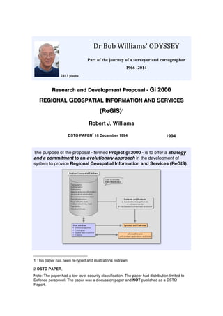
  • 1. 2013 photo Dr  Bob  Williams’  ODYSSEY     Part of the journey of a surveyor and cartographer 1966 -2014 Research and Development Proposal - Gi 2000 REGIONAL GEOSPATIAL INFORMATION AND SERVICES (ReGIS)1 Robert J. Williams DSTO PAPER 2 16 December 1994 1994 The purpose of the proposal - termed Project gi 2000 - is to offer a strategy and a commitment to an evolutionary approach in the development of system to provide Regional Geospatial Information and Services (ReGIS). 1 This paper has been re-typed and illustrations redrawn. 2 DSTO PAPER, Note: The paper had a low level security classification. The paper had distribution limited to Defence personnel. The paper was a discussion paper and NOT published as a DSTO Report.
  • 2. 2 BACKGROUND 1993 At the 20th Steering Committee Meeting of the Digital Geographic Information Working Group hosted by Spain's Ministerio de Defensa Segente and held at Servicio Geografico del Ejercito in Madrid the United States member provided an Update on Product Developments. An addition to the DMA (Defense Mapping Agency) system is G2IS. "Global Geospatial Information and Services (G2IS) is worldwide precise spatially co-referenced information about the earth, arranged in a coherent structure to support measurement, mapping, monitoring, modeling, terrain evaluation, and spatial reasoning applications. Information may be tiled (geographically partitioned) and / or thematically layered and will be compatible with standard geographic information system (GIS) packages for ease of export, manipulation, update, and value-adding"3 . 1994 US Defense Mapping Agency DMA) - Headquarters 4 DMA HQ hosted a meeting at their Headquarters building on Monday 21 November. It was arranged by Mr Charles Hall, Deputy Director (International Operations). Topics included: • Welcome and introduction by Mr Hall followed by discussions with COL (Dr) Rich Johnson and Mr Hall on research topics including DMA's interoperability vision. • Visit to TASC (a private research organisation) with demonstration and briefing of GGIS (Geospatial Information and Services) project by Mr William MacDonald of DMA Systems Center, Mr Hall and scientists from TASC5 . • Demonstration and briefing at the Warrior Support Center, including MUSE (Mapping, charting and geodesy Utility Software Environment). • Further discussions with COL Johnson on long term research issues. The Global Geospatial Information and Services Initiative. In this current 'age of automation', the US Defense Mapping Agency (DMA) is taking positive steps toward supporting current and future mapping, charting, geodetic, and imagery requirements for products, information and services. DMA is committed to continually improve responsiveness to its users and to increasing its capability to satisfy a variety of 3 Refer to Report on a Visit to the United Kingdom and Spain, May 1993. 4 Refer to Report on a Visit to the United States of America and Canada, November 1994. 5 DMA, being a large organisation, has research and development done by a number of organisations (including their own Systems Center). In 'informal' discussions, it was indicated that they do not have a 'dependence' on the service laboratories and suggested that there is a trend to use private research laboratories (such as TASC). As background information, the 'Earth Observation Magazine' (October 1994) reports that "TASC (The Analytic Sciences Corp) has been chosen as a lead subcontractor on a Raytheon-led team to develop an environmental surveillance and air traffic control system for the Amazon region. The potential five-year contract is valued at more than US$1 billion, which TASC's share expected to be as much as US$70 million. TASC will provide information technology for environmental surveillance and weather data processing".
  • 3. 3 anticipated digital information requirements. These efforts are embodied in the Global Geospatial Information and Services (GGIS) initiative. GGIS is a commitment to information production, information management, information dissemination and information servicing through fostering and developing standards, providing technical and administrative support, and developing and certifying software tools for use with global geospatial information. GGIS encompasses current production and distribution and is very much a part of the organisational change and digital production modification of the Agency. Full implementation of GGIS is an evolutionary process that has already started. GGIS is not a system that will come on line in the future; fully matured, GGIS is the way DMA will do business in the future. The emphasis will be on providing and servicing global, geospatial information instead of standard products. That information will be timely, capable of being tailored, and user accessible in the GGIS distributed 'data warehouse'. The concept of Global Geospatial Information and Services (GGIS) is the most revolutionary change in the provision and use of geographic information for many decades. Up until now, digital products have, in most cases, been digital representations of traditional products, such as maps. GGIS offers a managed evolutionary path to electronic distribution of information and services, as well as effectively addressing interoperability issues. The vision, and the road map to achieve it, will facilitate joint interoperability for the Command, Control, Communications and Intelligence (C4I) community. Because this initiative has the potential of impact future ADF systems (either directly or indirectly), a copy of a paper by Roberta Lenczowski has been included for all addressees. It is vitally important that the ADO monitor this initiative. INTRODUCTION The Defence Force has been intimately involved over a number of years in programs to map and chart our own country, its sea and air approaches as well as being involved in cooperative ventures with several neighbouring countries to map their areas of interest. In more recent times these efforts have been directed to acquiring this information in digital form, making its use much more flexible and expanding the opportunities for military exploitation. Several Defence organisations have been actively acquiring databases of infrastructure information with geographic descriptors for both strategic planning and tactical use. Handbooks of geographic information have been produced of several areas for military use. Increasingly, a great deal of interest is being shown by the military in the development of digital terrain models, terrain analysis products, digital hydrography, air chart products in digital form, the use of graphics in command and control systems, and applications of remotely sensed images from satellite and aircraft mounted systems. Within the civilian community the potential of computer based coordinated land management systems is being exploited and the systems developed
  • 4. 4 incorporate much of the technology that is available for the collection, collation, and distribution of synthesised land related data. These systems are providing regional data bases, much of which has potential for military use. The need to acquire, manage, distribute and use geographic information has been emphasised in policy documents for many years. POLICY GUIDANCE Dr (now Prof) Paul Dibb in his Review of Australia's Defence Capabilities (March 1986) observed that "the foremost peacetime defence requirement is reliable and comprehensive intelligence about our own strategic environment". The White Paper - The Defence of Australia, 1987 (prefaced by the Hon.K.C.Beazley) - further endorses the belief noting that "the availability of comprehensive and up-to-date maps and charts, together with a detailed knowledge of the environment and its infrastructure, is fundamental to the effective control of military operations". Australia's Strategic Planning in the 1990s (prefaced by the Hon. Robert Ray) notes that "there are two principle factors that underpin Australia's strategic situation. These are the enduring features of our geography and location, and the reality of political, social and economic change within the countries around us". Strategic Review 1993 (prefaced by the Hon. Robert Ray) is part of a continuous cycle of defence planning documents and emphasises "the importance that the Government attaches to enhancing our security in and with the region". The planning document notes that "the enduring nature of our land, sea and air environment provides the long-term basis for our defence planning. Australia's geography continues therefore to be a central factor in deciding the characteristics of our military forces and our strategic concepts for their use". The Review stresses that "intelligence collection and evaluation are necessary to monitor regional developments, develop intelligence databases, provide information on specific regional crises, and support ADF operations. By providing a picture of the strategic environment, intelligence provides a basis for planning and force structure development". Furthermore, it notes that "a key measure of the effectiveness of the national intelligence system is how well it can support both national security policies and ADF operations. Systems are needed to fuse strategic and tactical intelligence, gathered from a variety of sources, into a usable format for commanders, eg through the development of distributed information systems". As a result of these high level directives there is now a trend to give geographic intelligence collection and analysis the highest priority, particularly
  • 5. 5 in a time of reduced likelihood of hostility. But what constitutes military geographic information and where is the area of defence military interest? MILITARY GEOGRAPHIC INFORMATION (MGI) Detailed knowledge of the terrain, hydrography, airspace, climate and infrastructure of Australia's area of likely military operations has the potential to be a significant force multiplier in any future conflict in our region (Figure 1). Figure 1: MGI categories MGI categories Military geographic information can be considered to be a part of the overall requirement for intelligence by the military, along with strategic and economic intelligence to assess the intentions of potential enemies and intelligence about an enemy's capabilities and equipment. The geographic information requirement can broadly be divided into three areas, namely: • Infrastructure information. Infrastructure is a substructure or underlying foundation on which the continuance and growth of a community, state and country depends. Infrastructure includes man- made structures and facilities, such as roads, schools, power plants, transportation and communication systems, and their locations. This group can logically be sub-divided into a number of themes; one such arrangement being administration and institution, population and habitation, road infrastructure, rail infrastructure, air infrastructure, sea infrastructure, telecommunications, power and fuel, water resources, Geology and soils Land ownership Natural vegetation Environmental data Population Road infrastructureTopography Hydrography Bathymetry Port facilities Airport facilities Utilities (Power and water)
  • 6. 6 industry and commerce, health and medical, and recreational themes. • Terrain intelligence which is primarily concerned with the natural features of the terrain, and includes themes related to physiography, hydrography and oceanography. • Environmental data. This grouping includes characteristics pertaining to the environment which, at this point in the evolution of geographic databases, have been largely ignored. This grouping could include details describing the atmosphere, climates, weather conditions and so on. Data representation When considering defence requirements for geographic information, the knowledge of terrain and its impact on military operations is viewed as fundamental. The terrain is not only the land surface but the natural and man- made features on or beneath the surface; features which can be described with attributes pertinent in assessing the conduct of battle. The defence force therefore requires knowledge about the terrain in one or more of the following forms: • in descriptive form such as a map or display where the image is clear and unambiguous to the human eye; • as discrete positional data, where the relationship established between two points or a number of points is unambiguous, as in navigation systems and elevation models; • as relational terrain data, enabling its analysis and evaluation with other data pertinent to the conduct of military operations. Areas of application The emerging applications for the use of digital geographic information (often termed geospatial information) can be summarised as: • Navigation and guidance. The requirement is for positional data and map displays which support the navigation of an air or ground vehicle or sea vessel and which is linked to the integral system of the vehicle which may include terrain referenced navigation systems. • Surveillance, targeting and weapons. The requirement is for terrain data to support surveillance of the battlefield for the acquisition of targets. Terrain data is also required in planning and siting of some weapon systems. • Command, control and communications. The state of the art in information technology itself is driving this requirement for army and air force command and control systems. The need extends from simple background map displays to the sophistication of terrain analysis databases.
  • 7. 7 Figure 2: MGI areas of application Military functions The scope of military functions include: • Strategic analysis of potential enemy capabilities and intentions; • Contingency planning; • Logistic planning; • Operational planning; • Tactical operations on the ground, in the air and on and below the sea surface; • Training; and • Force structure and equipment capability definition. PROPOSED PROJECT It has become increasingly obvious that in order to achieve effective and efficient operation of defence systems in performing the military functions, geospatial information must be readily available to the operational systems. The purpose of this proposal - termed Project gi 2000 - is to offer a strategy and a commitment to an evolutionary approach in the development of system to provide Regional Geospatial Information and Services (ReGIS). This project logically follows, and responds to recommendations to, previous defence studies and plans, notably 'Defence Geographic Information Command Information Requirements Consultancy' and 'Australian Defence Force Military Geographic Information Development Plan'. Navigation and guidance Intelligence Surveillance Command, control and communications Targeting and weapons
  • 8. 8 Vision The Australian Defence Organisation will have the Defence component of a National Spatial Data Infrastructure and accredited analytical tools to utilise the geospatial information for analysis, presentation, modelling, planning, rehearsal and operation consistently across operational units. Mission The mission is to provide scientific leadership in the development of advanced models and analytical tools for geospatial data, and to actively promote technological developments through committees, seminars, conferences and the like to ensure 'real outcomes' on the investment in the research, both to the Australian Defence Organisation and to Australia in general. The objectives are: • Spatial data infrastructure. To promote, foster and participate in the design of the Defence component of a National Geospatial Data Clearinghouse. • Standards. To provide standards and guidelines necessary to enable effective use and integration of geospatial information. • Organisational framework. To strengthen the organisation and management structures involved in the management and use of geospatial information. • Education and training. To actively encourage and involve academia through collaborative activities. • Industry involvement. To actively encourage and involve industry through collaborative activities, and to facilitate technology transfer to commercial organisations. These objectives comprise a radically different conceptual approach to the management and use of military geographic information. This approach essentially consists of two key components: the generation and management of geospatial information; and the supply and distribution of services. Placed into a regional context, the capability might be termed Regional Geospatial Information and Services (ReGIS). Therefore the goals are to: • Design; • Prototype; • Conduct a pilot project; and • Facilitate the implementation of ReGIS.
  • 9. 9 ReGIS Concept Expanding on the components, the overall concept comprises an integration of modules designed to acquire, maintain and distribute thematic information; to construct and distribute standard products; and to provide user services and training (Figure 3). Figure 3: ReGIS concept Regional Geospatial Database. As an example only, it seems that we need to design and develop a multi-level database which could become the Defence component of a National Spatial Data Infrastructure. This model could include four levels: • Level 0 - Strategic level. The scale range for strategic level enquiries ranges from 1:400000 through to smaller scales as required by decision support applications. The area of coverage of this database would extend over the entire world with access optimised for the Area of Defence Military Interest, including Australia, South-East Asia and the South-West Pacific. • Level 1 - Operational level. The scale range for operational level enquiries includes scale ranges from 1:80000 through to 1:400000 as
  • 10. 10 required by applicable decision support applications. The area of coverage of this database would extend over the entire world with access optimised for the Area of Defence Military Interest, including Australia, South-East Asia and the South-West Pacific and, generally, along the transportation and communication lines and places having significant infrastructure facilities. • Level 2 - Tactical level. The scale range for tactical level enquiries includes scale ranges from 1:20000 through to 1:80000 as required by tactical decision support application including area studies, terrain analysis, infrastructure directories and background display. • Level 3 - Urban level. The scale range for urban / facilities level enquiries includes scale ranges from 1:5000 through to 1:20000 as required by applicable decision support applications, urban and cantonment information systems, terrain analysis, facilities management and impact assessment. This level requires the information content to meet the resolution and accuracy needs of urban maps, facilities maps, terrain analysis products, and infrastructure directories. The information content needs to be organised into a set of generic themes as described previously. The information needs to be feature coded and appropriately described through the use of attribute tables to meet the requirements in the aeronautical, topographic, hydrographic and environmental domains. In addition the information needs to be periodically revised and maintained. Products and services As an example only, it seems that we need to design and develop a range of products and services. Initially, the products would include those based on datasets being developed by the Digital Geographic Information Working Group (DGIWG). Those currently being developed include: • Background Display. The requirements for the Background Display Dataset (BDD) are those features and attributes needed for display of geographic information as a background for overlay of other typically non-geographic information in command and control systems, mission planning systems, and so on. The Digital Chart of the World (DCW) fulfils the requirements for the base level of this dataset. • Toponymic Data. The requirements for the Toponymic Dataset are to provide a digital list of geographic place names and associated support information to be used both as a standalone dataset and in conjunction with other datasets. • Transport and Logistics Planning. The requirements for the Transport and Logistics Dataset (TLD) are those features and attributes to support logistics planning and movement of personnel and materiel. It is intended to provide detailed information on transportation routes,
  • 11. 11 such as roads, railroads, canals and navigable waterways, air facilities, maritime ports, and so on, and may be combined with user supplied data to support additional logistics planning requirements. • Terrain Analysis. The requirements for the Terrain Analysis Dataset (TAD) are those features and attributes needed to perform traditional military terrain analysis, including cross-country movement, line of sight and range and bearing calculations. TAD is actually a combination of several datasets - Background Display Data or GEOMAP, Digital Nautical Chart (DNC) and Digital Terrain Elevation Data (DTED). • Air Information. The requirements for the Air Information Dataset (AID) are to provide a graphic database of airspace structures and vertical obstructions on the terrain for low to very low altitude, Visual Flight Rules (VFR), and Instrument Flight Rules (IFR) for flight operation and planning use. AID comprises two subsets distributed separately: the AID-Aeronautical Information Subset (AID-Aero) and the AID-Obstruction Information Subset (AID-Obs). AID-Aero will contain all aeronautical information portrayed both on NATO designated aeronautical charts and on ICAO charts, particularly EnRoute Charts. AID-Obs will contain selected geographical features required for safety and reference in low to very low air navigation. The services could also include electronic queries, such as spatial analysis; as well as access to catalogues of available information, spatial data expertise and training. Of fundamental importance in the provision of analysis is the use of certified applications and tools. Research needs to be done to identify processes useful for browsing, planning systems, decision support systems, and operational command and control systems. The long-term goal is to establish a user accessible data warehouse. EVOLUTIONARY DEVELOPMENT A report prepared by the Directorate of Operational Information Systems, Force Development (Joint) Branch in 1994 identified in excess of thirty projects in various stages of development and acquisition, while a study sponsored by the same branch in 1993 identified hundreds of separate groups and units that use military geographic information. Although DI(G) ADMIN 05-1 The Force Development Process requires that dependencies of a project on geographic information be identified in Part 2 of the project's Major Capability Submission, few, if any, have done so. In addition, the requirements for routine data collection and production of both standard and non-standard geographic products will be driven by assessment of the following:
  • 12. 12 • Strategic guidance; • Operational concepts; • Endorsed contingency plans and Australian Joint Service Plans; • Training requirements to meet CDF Preparedness Directives; and • Maritime requirements. Again, little to no effort has been put into translating these requirements into a strategy of the collection, management and distribution of geospatial information. As such, it is proposed that research and development follow a model of evolutionary development as shown in Figure 4 and include the following stages: Near Term (1995). In response to these deficiencies, the immediate tasks need to address as a minimum: • the transfer of technology to Project Directors by way of advice on geospatial technologies and implications to their respective projects. (This process has been managed in a somewhat informal manner to date; the exception being the Mine Warfare System Centre Project where DSTO has had formal tasks in place for a couple of years.) • the determination of Geospatial Information Requirements for Defence decision support, command and control, surveillance and intelligence systems through a formal analysis of policy and planning documents and system capability proposals. • assessment of academia and industry expertise in the management and use of geospatial information. • detailed design of the full scope of this Project to the year 2000. Mid Term (1995-97). As a result of the near term activities, it will be possible to address issues in a methodical manner. It is anticipated that issues will include: • initial design of the Defence component of the National Spatial Data Infrastructure clearinghouse. • design and development of an electronic catalogue of information and services. • determination of procedures to facilitate certification of geospatial data, algorithms and processes. • design and development of advanced geospatial data models, specifically for infrastructure (airports, ports, etc) and environmental information, such as that concerned with oceanography and the land- sea-air interfaces. Objective (By 2000). It is envisioned that the following will be achieved:
  • 13. 13 • infological and datalogical studies will be complete enabling the design of a ReGIS data warehouse. • development of an accredited geospatial data model to define our environment and its infrastructure. • development of accredited 'intelligent' spatial querying tools. • development of techniques for mission planning and rehearsal. Figure 4: Evolutionary development Benefits of the ReGIS concept The benefits of implementing a system for Regional Geospatial Information and Services promise to be quite substantial and can be summarised as: ReGIS Information. It is envisioned that the information will: • Provide regional, accurate, precise and current spatially coreferenced information about the area of defence military interest. • Use standard data exchange formats to ensure geospatial interoperability for command support systems, mission planning systems, navigation systems, and so on.
  • 14. 14 • Support measurement, mapping, visualisation, monitoring, modelling, terrain evaluation, and spatial reasoning applications. • Harmonise data standards and related technical issues with respect to agency to agency and organisation to organisation. • Facilitate interaction with Defence, Commonwealth, State and international organisation with respect to efforts to collect, maintain and disseminate geospatial information and its metadata. • Promote data structure and data base technology advances. ReGIS Services. It is envisioned that the services will: • Deliver the right information at the right time through electronic data transfers and deployable MGI desktops. • Develop community exchange and use of standards both with respect to data models and elements, and certified toolkits. • Offer responsive technical guidance through analytical tools, improved requirements identification and electronic training. • Certify new technological capabilities and manage value adding strategies. • Support multi-level electronic gateway interfaces and bulletin board access. Overall. It is envisioned that the following will be achieved: • Interoperability through the use of consistent geospatial data across operational units. • Flexibility through diverse uses of the same data for analysis, presentation, modelling, planning, rehearsal and operation. • Currency of value-adding policies for diverse and remote data updates by others in a timely manner. • Speed through on-line delivery for high priority data and update information. PROJECT IMPLEMENTATION It is not possible to offer a detailed implementation plan at this stage as this will depend on the degree of acceptance by both DSTO and the project sponsor on the philosophy underpinning Project gi2000; that is, the concept of providing Regional Geospatial Information and Services. Nevertheless, it is envisioned that the project will be managed as a series of concurrent tasks organised through short, medium and long term activities.
  • 15. 15 Initial Phase As noted above, 'near term' activities include the transfer of technology to the ADF (Australian Defence Force), DIO (Defence Intelligence Organisation) and the non-Defence community; a formal determination of geospatial information requirements for Defence; the assessment of academia's and industry's expertise; and conducting a detailed design of the project. Technology transfer is an on-going process and will continue throughout the life-cycle of this project. Recent and current activities include: • monitoring developmental efforts in digital geographic information exchange standards, advising HQADF (Headquarters ADF) on the applicability of the standards and products to emerging systems and contributing to working groups involved in developing and implementing the standards and products through task - Digital Geographic Data Specifications and Products. • advice to the Project Director of the Mine Warfare System Centre Project through task - Mine Warfare Command Support System Development. • Seminar 'C2 Towards 2005' sponsored by the Directorate of Operational Information Systems FD(Joint). • semi-formal advice to DIO, RASvy (Project PARARE) and Hydro RAN (Project SEA 1430). • publications of papers and presentation at conferences and workshops. Determination of geospatial information requirements. Of immediate concern is the lack of formal knowledge of the requirements for geospatial information. A process to analyse operational concepts, military appreciations, intelligence assessments and the capabilities of platforms and systems should commence at the earliest convenience; say, be conducted in the first half of 1995. Procedures also need to be established to ensure the process remains continuous (Figure 5). Academia and industry expertise. Unfortunately the level of expertise within academic and research organisations, and private industry varies considerably with respect to the technologies used in the management and use of geospatial information. An assessment needs to be conducted, say, during 1995, to enable effective research and development to be performed. It should not be concluded that a CRC (Cooperative Research Centre) automatically implies a centre of excellence. Detailed project design. Although the concept can be described now, the full extent and scope of the project cannot be explicitly described until the requirements are more clearly defined. It is proposed that: • a preliminary design be completed by April 1995 (to enable allocation of funding for the next financial year).
  • 16. 16 • the full project design be completed by June 1995. Figure 5: Determination of user requirements Mid-Term Phase This phase of the project will include a number of key developmental activities fundamental to creating a 'foundation' on which to lay the 'value-adding' capabilities of the final phase. These include:
  • 17. 17 • Defence component of the National Spatial Data Infrastructure (NSDI). As noted earlier, NSDI means "the technology, policies, standards and human resources necessary to acquire, process, store, distribute and improve utilisation of geospatial data"; while the NSDI Clearinghouse means "a distributed network of geospatial data producers, managers and users linked electronically". Consequently, this activity will require research and development by DSTO, as well as liaison with Commonwealth agencies, allied Defence organisations and interaction with key projects such as Project PARARE, Project SEA 1430 and Project Aeroinf (name to be confirmed). • Electronic catalogue. The design and development of an electronic catalogue will facilitate and influence the design of a service to distribute metadata (summary data about products) to Defence customers, as well as conducting a stocktake of Defence geospatial assets. The potential exists for collaboration with AUSLIG and US DMA. • Geospatial data and software environment. This activity will include the determination of procedures to facilitate the certification of geospatial datasets, algorithms and processes. This issue becomes progressively more important as systems progress from concept demonstrators, to planning systems, to decision support systems, and to operational command and control systems. This activity appropriately needs to be performed under the auspices of the Digital Geographic Information Working Group (DGIWG), including that organisation's Technical Committee and Panels of Experts. • Advanced spatial data models. The applications required for mission planning, rehearsal and operation (as required in the final phase) require new and more sophisticated geospatial data models and algorithms. This activity requires innovative thought and is an area where Australia can truly contribute in geospatial technology. All new models or algorithms need to be validated. Objective Phase (By 2000) This phase of the project will include final ReGIS design and advanced analytical capabilities. Activities would include: • infological and datalogical studies will be complete enabling the design of a ReGIS data warehouse. • development of an accredited geospatial data model to define our environment and its infrastructure. • development of accredited 'intelligent' spatial querying tools. • development of techniques for mission planning and rehearsal. RESOURCE IMPLICATIONS
  • 18. 18 Personnel It is proposed to establish a team of scientists and support staff and to work within a controlled and managed environment. Obviously, the personnel listing includes either the recruiting of new staff or the reallocation of staff from within DSTO and consequently the proposal needs approval from DSTO management. The suggested staffing is: Project coordinator / manger PRS Liaison officer (DSTO / Academia / Industry) SRS Standards SPO(C) Configuration management / Legacy systems PO2 Scientific disciplines - areas of expertise MC&G SPO(C) Military applications (particularly Joint) SPO(B) Technical clerk Project administration PO1 Literature searches PO1 Technical officer ITO( ) Equipment Equipment requirements are planned to be minimal. Rather than purchase 'state-of-the-art' computer hardware and expensive software packages, it is planned to acquire information through visits, trade shows and academic and industry involvement. It may be possible to obtain obsolete photogrammetric equipment to undertake tests for certain information sets not currently being worked on elsewhere; such as detailed plots of infrastructure facilities. The predicted equipment requirement is: Existing computer equipment upgraded periodically Minor peripherals (such as CD-ROM units) (Possible acquisition of surplus photogrammetric equipment) Travel Travel, both local and overseas, is particularly important in this project. With limited staffing and equipment, maximum benefit must be obtained from external sources. Estimated travel requirements are: (Regular visits to ADF and DIO staff) Conferences, symposiums and trade shows DGIWG Meetings (2 overseas meetings per year) Pre-eminent overseas conference (every two years)
  • 19. 19 Note: Should Australia be offered full membership to the Digital Geographic Information Working Group (DGIWG), the opportunity exists to participate in the Technical Committee and special working groups. It seems logical that DSTO's involvement should be at that technical level where we can influence research and development issues. Training Education and training is viewed as a two way process. Staff need training, say through participation on short courses, as well as contributing in presentations at universities and technical workshops. EXTERNAL ACTIVITIES Involvement of other DSTO divisions and groups Research activities within this project transit the areas of expertise of a number of divisions and groups within DSTO, such as LSOD, C3ISE, CSSG, IM, ISG, SSA and HCI Lab. As yet, no dialogue has been initiated with Chiefs, Research Leaders and Heads of Groups to plan a program of activities. Involvement of academia It is proposed to establish formal and informal agreements with academic institutions having recognition as centres of excellence in relevant scientific disciplines. Involvement can be through: Research contracts Reciprocal seminars/workshops Development of training packages Involvement of industry It is proposed to establish formal and informal agreements with private industry, of known competence in geospatial technologies. Involvement can be through: Development of prototypes and pilots Contract data acquisition and processing Collaborative activities It is proposed to establish formal and informal agreements with Commonwealth, state and international organisations, of known competence in geospatial technologies. Activities may include harmonisation of similar activities, regional pilot projects and long-term research. Summary of resource expenditure
  • 20. 20 The scope of external activities is yet to be fully assessed, but planning of this part of the project would clearly be influenced by the amount of available funding. Project management It is proposed that this project be fully accounted and managed through a series of reviews which include 'decision points' on project termination, expansion or maintenance of the specified plan of activities. The proposed Critical Reviews (decision points) are: • Initial Review • Detailed plan of activities to the year 2000 • Presented in April 1995 • Mid-term Review • Progress on evolution from concept demonstrator, through prototype, and pilot project stages including cost//benefit analysis • Presented in April 1997 • Final Review • Presented in November 1999 BENEFITS / IMPLICATIONS Benefits This project proposes a planned and managed program of activities culminating in the design of a geospatial information and services system. The information will: • Provide regional, accurate, precise and current spatially coreferenced information about the area of defence military interest. • Use standard data exchange formats to ensure geospatial interoperability for command support systems, mission planning systems, navigation systems, and so on. • Support measurement, mapping, visualisation, monitoring, modelling, terrain evaluation, and spatial reasoning applications. The services will: • Deliver the right information at the right time through electronic data transfers and deployable MGI desktops. • Offer responsive technical guidance through analytical tools, improved requirements identification and electronic training. • Certify new technological capabilities and manage value adding strategies.
  • 21. 21 • Support multi-level electronic gateway interfaces and bulletin board access. The overall benefit will be: • Interoperability through the use of consistent geospatial data across operational units. • Flexibility through diverse uses of the same data for analysis, presentation, modelling, planning, rehearsal and operation. • Currency of value-adding policies for diverse and remote data updates by others in a timely manner. • Speed through on-line delivery for high priority data and update information. Outcomes • Spatial data infrastructure. The Australian Defence Organisation will have the capability to construct the Defence component of a National Geospatial Data Clearinghouse. • Standards.The Australian Defence Organisation will have standards and guidelines necessary for the effective use and integration of geospatial information. • Organisational framework. The Australian Defence Organisation will have the organisation and management structures to manage and use geospatial information. • Education and training. Academia will be aware of the Australian Defence Organisation's requirements with respect to geospatial information and services. • Industry involvement. Industry will be aware of the Australian Defence Organisation's requirements with respect to geospatial information and services. Implications The 'basic concept' (that of geospatial information and services) outlined in this paper models similar projects in the United States, United Kingdom and Canada. In addition, those countries have made a commitment to the 'philosophy' of developing internationally accepted standards and are committed, along with eight other countries in the DGIWG organisation, to embark on production of DIGEST products. The result of the associated activities will be that geospatial data will be provided to operational systems in accordance with the standards developed through the DGIWG committees. The implication of not endorsing the approach outlined in this proposal will be that the Australian Defence Organisation will lag in its development of the technology described in this paper with the ultimate implication being that ADF systems will not be able to being fully effective in joint force operations.
  • 22. 22 DEFINITIONS National Spatial Data Infrastructure means the technology, policies, standards and human resources necessary to acquire, process, store, distribute and improve utilization of geospatial data. National Geospatial Data Clearinghouse means a distributed network of geospatial data producers, managers and users linked electronically. NOTES The principal outcome is to ensure the efficient and effective operation of ADF intelligence; command and control; surveillance; weapons; and navigation systems with respect to the use of geospatial information. REFERENCES / ACKNOWLEDGEMENTS References Dibb, P. (1986), Review of Australia's Defence Capabilities, March 1986. Beazley, Hon.K.C. (1987). White Paper - The Defence of Australia, 1987. Ray, Hon. Robert (1990). Australia's Strategic Planning in the 1990s. Ray, Hon. Robert (1993). Strategic Review 1993. EASAMS (1993). A Defence Geographic Information Command Information Requirements Consultancy, EASAMS (Aust) Ltd 9214/00/0002 Issue 2.0 dated 11 Jun 1993. DOIS (1994). Australian Defence Force Military Geographic Information Development Plan, (Draft Version 1.0), prepared by Directorate of Operational Information Systems, Force Development (Joint) Branch. Acknowledgement This proposal was written by Dr.R.J.Williams Senior Research Scientist 16 December 1994.
  • 23. 23