Separability Analysis of Integrated Spaceborne Radar and Optical Data: Sudan ...
Validation of Satellite DEM Data for Landslide Modeling
1. Validation of Satellite Digital Elevation Model Data
through Field Measurements to Help Improve
Landslide Susceptibility Modeling
Leigh Baggett, Rob Graham, Cameron Kowalski
Earth System Science
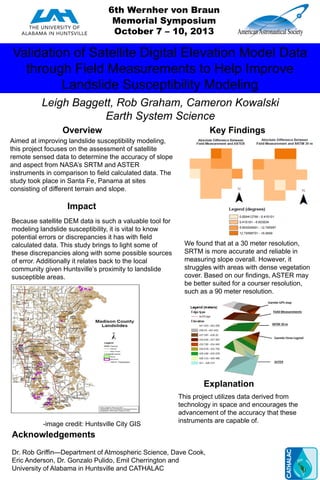
Overview Key Findings
Impact
Explanation
Acknowledgements
Aimed at improving landslide susceptibility modeling,
this project focuses on the assessment of satellite
remote sensed data to determine the accuracy of slope
and aspect from NASA’s SRTM and ASTER
instruments in comparison to field calculated data. The
study took place in Santa Fe, Panama at sites
consisting of different terrain and slope.
We found that at a 30 meter resolution,
SRTM is more accurate and reliable in
measuring slope overall. However, it
struggles with areas with dense vegetation
cover. Based on our findings, ASTER may
be better suited for a courser resolution,
such as a 90 meter resolution.
Because satellite DEM data is such a valuable tool for
modeling landslide susceptibility, it is vital to know
potential errors or discrepancies it has with field
calculated data. This study brings to light some of
these discrepancies along with some possible sources
of error. Additionally it relates back to the local
community given Huntsville’s proximity to landslide
susceptible areas.
This project utilizes data derived from
technology in space and encourages the
advancement of the accuracy that these
instruments are capable of.
Dr. Rob Griffin—Department of Atmospheric Science, Dave Cook,
Eric Anderson, Dr. Gonzalo Pulido, Emil Cherrington and
University of Alabama in Huntsville and CATHALAC
6th Wernher von Braun
Memorial Symposium
October 7 – 10, 2013
-image credit: Huntsville City GIS