7. Image Captions (in order of appearance):
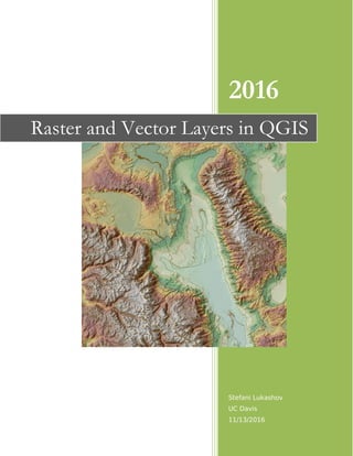
Image 1: Ultra Prominent Point Topography Map of White Mountain
Image 2: Moderate Flooding in Jacksonville, FL with Sea Level Rise of 5 ft
Image 3: Severe Flooding in Jacksonville, FL with Sea Level Rise of 12 ft
Image 4: Extreme Flooding in Jacksonville, FL with Sea Level Rise of 25 ft
Image 5 (bonus): Flooding in Jacksonville, FL as the Result of Sea Level Rise
Raster data is a data model that is based on comprising an image of equal sized
pixels in a grid format where each cell has an assigned specific value (Campbell et
al). While file sizes may be large depending on the spatial resolution of the image,
raster data is relatively easy and cheap to produce (Campbell et al). The resolution
of an image should be high enough to capture the smallest feature necessary
(Campbell et al). Vector data is more complicated as there is no specific grid, but
elements that make up the image such as a point, polygon, or line. Zooming in on
an image loses clarity in a raster layer, but a vector layer will be unaffected.
Vector data is very useful for creating topology as it has inherent rules to avoid
undershooting lines, overshooting lines, or leaving polygons open. Vector data also
results in smaller file sizes than raster data. The goal of a project, and the
parameters of a project, will dictate if vector data or raster data will be used.
In this report, raster data is used to model sea level change in southeast Florida.
Raster data was used in this scenario because it is easy to transform the elevation
of each pixel from meters to feet with a simple ‘raster calculation’. While making a
quick model is easy with raster data, it did result in a map that is extremely
pixelated toward the outer edges of where the land will become flooded.
Jacksonville was chosen to model flooding due to sea level rise as it is a fairly
known, large city near on the coast of Florida. Other cities are included in the map
to help users visualize the scale of the map. Florida itself does not have vary much
in terms of elevation so Jacksonville is extremely susceptible to changes in sea
level. The levels of sea level rise were estimated from the predictions outlined in
the Intergovernmental Panel on Climate Change (IPCC, Chapt 13).
8. Works Cited
Campbell, Jonathan, and Nick Burkhart. "Chapter 6: Data Models for GIS." Essentials of
Geographic Information Systems. By Michael Shin. Vol. 2. N.p.: Flatworld
Eduacation, 2016. N. pag. Print.
EarthExplorer. USGS, n.d. Web. 12 Nov. 2016. <http://earthexplorer.usgs.gov/>.
Open Geospatial Consortium Web Map Service (OGC WMS). USGS, n.d. Web. 12 Nov.
2016.
<http://isse.cr.usgs.gov/arcgis/services/Orthoimagery/USGS_EROS_Ortho_NAIP/Imag
eServer/WMSServer?request=GetCapabilities&service=WMS>.
Switzerland, Bern, comp. Climate Change 2013: The Physical Science Basis. Rep.
Intergovernmental Panel on Climate Change, 29 Jan. 2016. Web. 11 Nov. 2016.
"Ultra-prominent Peak." Wikipedia. Wikimedia Foundation, 30 Sept. 2016. Web. 13 Nov.
2016.