Oriented Ice Wedge Polygons
•
0 likes•79 views

This document discusses how oriented ice-wedge polygons near drained lakes and meanders in Alaska form parallel to the direction of sediment deposition from receding bodies of water. As water recedes, it leaves behind oriented deposits known as point bars. Tension cracks in the soil then propagate perpendicularly to the direction of maximum tension, which is parallel to the point bars. Therefore, ice-wedge polygons near former water bodies exhibit oriented, parallel patterns that match the depositional orientation of sediments from receding water margins. Maintaining oriented patterns farther from water is difficult due to influences from other environmental factors.
Recommended

Recommended
More Related Content
What's hot
What's hot (20)
Similar to Oriented Ice Wedge Polygons
Similar to Oriented Ice Wedge Polygons (20)
Recently uploaded
Recently uploaded (20)
Oriented Ice Wedge Polygons
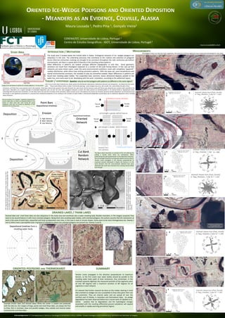
- 1. Example (frozen lakes and drained lakes) While the center is coated and protected with the lake-ice, the margins of bogs, ponds and small thaw lakes, are always the first to thaw. Rich in oriented, close and parallel wedges, they subside and channel water around ponds and thaw lakes. ORIENTED ICE-WEDGE POLYGONS AND ORIENTED DEPOSITION - MEANDERS AS AN EVIDENCE, COLVILLE, ALASKA MEASUREMENTS Deposition Maura Lousada 1, Pedro Pina 1, Gonçalo Vieira2 CERENA/IST, Universidade de Lisboa, Portugal 1 Centro de Estudos Geográficos - IGOT, Universidade de Lisboa, Portugal 2 INTRODUCTION / MOTIVATION maura.Lousada@ist.utl.pt F F’ S S’ 1 2 3 F F’ 1 2 3 1- High Velocity 2- Med. Velocity 3- Low Velocity Cut Bank Random Network Depositional timelines Oriented Network Deposition Erosion Point Bars Depositional timelines ORIENTED POLYGONS AND THERMOKARST DRAINED LAKES / THAW LAKES Depositional timelines from a receding water body STUDY AREA ALASKA Imagery from WorldView-III satellite (0.5 m/pixel), (8Bands), ( 7 of July, 2015). The study area is located below the Colville delta in Alaska. Orthogonal networks of ice- wedges polygons are ubiquitous in this area. The underlying processes that contribute to the creation and evolution of polygonal terrain (thermal contraction cracking) are thought to be consistent throughout the cold, continuous permafrost environments, yet there is a great deal of diversity in the resulting surface patterns. Often differences in patterns are evident amongst different (topographic or soil) sites. Some geometric variations can result from rheological responses to a number of site-scale forcing factors. In this case we find networks just some meters apart, under the same environmental conditions; some with completely “apparent” random distribution, while others have striking symmetric patterns. With the same soil, same temperatures and overall environmental constrains, the variables at play are somewhat isolated. Major differences in patterns are found near receding water bodies. The suspended load, overtime, leaves directional deposits parallel to the water line, and cracks seem to be developing with the same orientation, according to the settlement layout. All polygons were cut into the main segments, the azimuth of these segments was measured and plotted in rose plots. The figure above illustrates an example of the soil suffering the pulling a tensile strain (from ice contraction). When pulled along the path perpendicular to the deposition direction, the soil strength should be much greater before fracture (Fig.A). Tension cracks propagate in the direction perpendicular to maximum tension! Illustrated in (Fig.B), the fracture is in the same direction that the cross-sectional sediment bars were deposited (the point bars direction) the cracking should exhibit low strength. Tension cracks propagate in the direction perpendicular to maximum tension, so the first cracks near water bodies should be parallel to the receding water body (path of least resistance), thus anisotropic. In the oriented networks digitized, the measured azimuths of the segments were all near 900 degrees with a maximum variation of 300 degrees for all segments in each network. It’s relevant that further research be done on this matter, bearing in mind that oriented ice wedges are very susceptible to thaw (also given their size and proximity). They can channel water and are spread all over the northern part of Alaska, in meanders and thermokarst lakes. Ice wedge degradation has been observed before but a recent work of Liljedahl et al., (2016) predicts that its degradation and the hydrological changes associated with the resulting differential ground subsidence will expand and amplify in rapidly warming permafrost regions. SUMMARY Normal evolution of a meander - sediments resulting from erosion (right side/ cut bank) are deposited bellow in the stream on others point bars. Even during the spring meltdowns, point bars are formed by deposition of fine sediments from receding water. Like it occurs with other materials (ex. plastic paints) the distribution (directions), settlement and even soil compaction , can determine the cracks path. These cracks follow mainly a mode I (of tensile opening). Local changes may occur, but usually the cracks follow the path of less resistance, until they find a new opened crack in the network. If the base material was spread in the same direction (ex. point bars), the first tension cracks will find its way along the less resistant path, (parallel to the point bars). Meanders are a typical example of orientated deposition and, all over the Artic were polygonal networks co-exist, the latter present an oriented pattern in its internal bend or depositional areas, coinciding with the point bars orientation. On the other hand, the near the cut banks of the meanders, where erosion occurs, the patterns are clearly not oriented, (previous aeolian deposition can be favoured over the fluvial). In the hypothesis presented It is assumed that mechanical properties of ice cracking in the vicinities of water bodies is directionally dependent (anisotropic) due to sediments deposition (from receding water) direction . Drained lakes and small thaw lakes are also ubiquitous in the study area and constitute also a water receding body. Besides meanders, in the imagery acquired, they seem to be second feature in with more oriented polygons. Being them also receding water bodies, with oriented polygons, the authors assume that the mechanism at work is the same of point bars: sequential and lined up deposition over time, in this case in oval or circular shapes. Some seem to be more homogeneous (ex. Swamp 1 and 2) others have a perceptible outer ring band of subsidence where the oriented polygons are present (ex. Swamp 3 and 4). Stereo-PhotogrammetricDigitalSurfaceModel(SETSM)fromthePolar GeospatialCenter,UniversityofMinnesota.(showsvisiblepointbars fromdirectionaldepositioncoincidentwithorientednetworks locations). Google Earth, Digital globe© , 6/2012 700 09’06.20N 1520 20’ 10.43”O Google Earth, Digital globe© , 8/2004 700 14’37.19N 1520 32’ 55.16”O C Average área: 214 m2 ,SD:104.5 Mean axis: 16.4 m, SD: 4 B Average área: 204 m2, SD: 108 Mean axis: 16.3 m, SD: 4 VHRImageWorldView-IIIsatellite0.5meters,8bands,fromJuly2015, Pan-sharpened,(showsvisiblepointbarsofdirectionaldepositionfrom themeanderswithorientedpolygons). 1 2 3 4 THEORY / HYPOTHESIS Question: why do we find polygons with patterns so different in the same region? Outside meandrer curve non-oriented polygons Point Bars / deposition with orientation/direction Oriented polygons inside meanders curves Tensilestrain C B Random network outside the cut bank Oriented network inside the meander curve /depositional area WorldView-III satellite (0.5m) Pan-sharpened, 2015 WGS_1984 / UTM_Zone_5N Random network outside of two meander curves Oriented polygons inside the meander curves A A Average área: 115 m2, SD: 53.9 Mean axis: 12.4 m, SD: 3.2 WorldView-III satellite (0.5m) Pan-sharpened, 2015 WGS_1984 / UTM_Zone_5N Oriented partial network of a drained lake D D WorldView-III satellite (0.5m) Pan-sharpened, 2015 WGS_1984 / UTM_Zone_5N Average área: 148 m2, SD: 63.3 Mean axis: 13.2 m, SD: 2.9 Oriented polygons in a partial drained lake E E WorldView-III satellite (0.5m) Pan-sharpened, 2015 WGS_1984 / UTM_Zone_5N Average área: 162.8 m2, SD: 74 Mean axis: 13.5 m, SD: 3 Acknowledgements: FCT (Fundação para a Ciência e a Tecnologia) SFRH/BD/89117/2012; CERENA - Projeto Estratégico UID/ECI/04028/2013; INFORGEO and WorlView -III Imagery.