
Recommended
More Related Content
Similar to General Atmospheric CirculationUnit 6bGeneral Ci
Similar to General Atmospheric CirculationUnit 6bGeneral Ci (20)
More from MatthewTennant613
More from MatthewTennant613 (20)
Recently uploaded
Recently uploaded (20)
General Atmospheric CirculationUnit 6bGeneral Ci
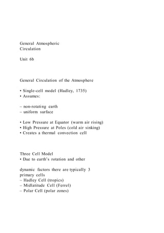
- 1. General Atmospheric Circulation Unit 6b General Circulation of the Atmosphere • Single-cell model (Hadley, 1735) • Assumes: – non-rotating earth – uniform surface • Low Pressure at Equator (warm air rising) • High Pressure at Poles (cold air sinking) • Creates a thermal convection cell Three Cell Model • Due to earth’s rotation and other dynamic factors there are typically 3 primary cells – Hadley Cell (tropics) – Midlatitude Cell (Ferrel) – Polar Cell (polar zones)
- 2. Three Cell Model Hadley Cell Primary High & Low Pressure Areas Equatorial Low Pressure (ITCZ) Subtropical High Pressure Subpolar Low Pressure Polar High Pressure Equatorial Low Pressure Intertropical Convergence Zone (ITCZ) ±10° N & S Thermally-induced low pressure Clouds and rain Limited wind (doldrums) Seasonal shift N-S Subtropical High Pressure • Dynamic high pressure – subsiding air of Hadley Cell – between 20° - 35° N & S
- 3. • Creates hot, dry air – Clear skies, limited wind (horse latitudes) – e.g., Bermuda High, Hawaiian High • Strengthen/weaken seasonally • Shift N & S with sun’s declination Subpolar Low Pressure • Dynamic low pressure – air forced to rise – along polar front • Cool, moist, cloudy • Frequent cyclonic storms – e.g., Aleutian Low, Icelandic Low • strengthen/weaken seasonally General Circulation (Side-View) General Circulation – Surface Winds Trade Winds (tropical) Westerlies (midlatitudes) Polar Easterlies
- 4. Trade Winds Trade Winds (tropical) – from subtropical highs to equatorial lows – northeast trades & southeast trades Westerlies Westerlies (midlatitudes) – from the subtropical highs to the subpolar lows (west à east) – tend to be wavy (meridional flow) Polar Easterlies Polar Easterlies – from polar highs to subpolar lows – variable, cold, dry winds www.atmo.arizona.edu General Circulation – Upper Air Flow (geostrophic winds) • Westerlies – subtropics à poles
- 5. – occur as Rossby Waves Jet Streams – areas of high wind velocity within the westerlies • Subtropical Jet – 20° - 50° N & S – 10,000 – 15,000 m • Polar Jet – 30° - 70° N & S – 8,000 – 12,000 m Jet Stream Rossby Waves http://svs.gsfc.nasa.gov/vis/a010000/a0 10900/a010902/ http://www.geography.hunter.cuny.edu/tbw/wc .notes/7.circ.atm/rossby_waves.htm Local and Regional Winds Ocean Circulation Unit 6c Local and Regional Winds
- 6. Land/Sea Breeze Mountain/Valley Breeze Katabatic Winds Compressional Winds Monsoons Land/Sea Breeze • thermal circulation • best developed in summer • land heats up during day, creates relative low pressure forming sea breeze • land cools off at night creates relative high pressure forming land breeze Mountain/Valley Breeze • thermal circulation • best developed in summer • slopes heat up during the day causing an upslope wind (valley breeze) • slopes cool off at night causing a downslope wind (mountain breeze)
- 7. Katabatic Wind Cold downslope wind cold air = greater density – therefore, moves downslope – cold air drainage Compressional Winds • Warm downslope winds – air warms as it descends downslope Compressional Winds n Examples: n Chinook (Rockies) n Santa Ana (S. Calif.) n Foehn (Alps) Monsoon • a wind system that reverses itself seasonally • thermal circulation • land cools off in winter, produces high pressure • land warms up in summer, produces low pressure Ocean Circulation
- 8. General Ocean Circulation Ocean Currents • Movement – frictional drag by prevailing winds – alteration by Coriolis Force – continental banking and deflection Gyres • Ocean currents circling around subtropical high pressure cells Warm Currents • Equatorial areas and East Coasts – e.g., Gulf Stream, N. Atlantic Drift, Kuroshio, Brazil, Agulhas Cold Currents • West Coast locations and Polar zones – California, Peru, Benguela, Canary, W. Australia
- 9. Atmospheric Pressure and Wind Unit 6a Atmospheric Pressure • pressure = force/unit area • surface pressure increases as weight of the column of air above increases • pressure decreases with altitude Measurement • Atmospheric pressure is mostly given in millibars (mb) on weather maps • Average sea level pressure = 1013.25 mb • Normal range: 980 mb – 1050 mb • Surface pressures are adjusted to sea level equivalent on most surface weather maps Barometer • Mercurial Barometer
- 10. (Torricelli, 1643) • Aneroid Barometer Horizontal Pressure Variation Isobars = lines of constant pressure Pressure Gradient • pressure gradient: – the change in pressure across a horizontal surface • pressure gradient force (pgf): – the force acting horizontally, tending to move air toward the direction of low pressure – steeper pressure gradient = greater pgf – greater pgf = greater wind speed Pressure Gradient • air moves from high to low pressure • wind is greatest where isobars are closest together (steep gradient) • wind is least where isobars are furthest apart (low gradient)
- 11. ß pressure gradient Temperature, Pressure, Wind • Varying surface temperatures create pressure differences • This creates “thermally-induced” pressure gradient • Leading to wind Dynamically-induced Pressure • Caused by converging or diverging air • Descending air causes high pressure • Ascending air causes low pressure HIGHLOW Wind Measurement • Direction: – “You name a wind from whence it came” --Mr. Balogh – Wind Vane • wind speed – Anemometer Wind Compass Wind Vane & Anemometer
- 12. Factors Influencing Wind • Pressure Gradient Force • Coriolis Force (Coriolis Effect) • Surface Friction Coriolis Force • caused by earth’s rotation • deflects wind from its intended direction: – to the right in N. Hemisphere – to the left in S. Hemisphere Coriolis Force • Amount of deflection increases – with wind velocity – with latitude Coriolis Force • creates geostrophic wind in the upper troposphere • geostrophic wind flows parallel to isobars
- 13. Surface Friction • Frictional resistance at surface causes lower wind speed • This reduces coriolis force • Resulting friction layer wind (surface wind) flows at an oblique angle to isobars High & Low Pressure Cells (for surface winds) • Cyclone = low pressure center – N.H.: counterclockwise inward – S.H.: clockwise inward • Anticyclone = high pressure center – N.H.: clockwise outward – S.H.: counterclockwise outward Geography 1001 Name____________________________ Continuing Eduation Exercise 4 Atmospheric Pressure and Wind Isobars and Wind. (refer to text Ch. 5) Lines of equal barometric pressure are called isobars and are typically drawn at 4 mb intervals. These isobars can be used to
- 14. interpret wind speed and direction, as air tends to be driven away from air of high pressure toward areas of low pressure. Air flow is affected by the pressure gradient force, acting perpendicular to isobars, as well as by the Coriolis effect and surface friction (see text fig. 5.9) 1. The four diagrams below depict the wind pattern around surface high and low pressure areas. Put an H in the middle of each of the high pressure cells, and an L in the middle of each of the low pressure cells. 2. Based on direction of wind flow, identify whether each is in the Northern or Southern Hemisphere by placing an NH or SH beside each letter. A B C D 3. The figure below shows maps of pressure distributions in several situations. Keeping in mind the influence of pressure
- 15. gradient force, Coriolis effect, and surface friction, use arrows to indicate the appropriate resultant wind directions corresponding to the isobaric patterns for geostrophic wind (left column) and surface wind (right column) on maps below High 1000 mb 1012 mb 1012 mb 1000 mb 510 mb 512 mb Low 512 mb 510 mb High Low
- 16. Drawing Isobars. Practice in drawing isobars (lines of equal pressure) on a weather map and figuring out how surface winds move diagonally across them will increase your ability to read and interpret not only daily weather maps, but also global maps of pressure and winds. The map on the following page shows barometric pressures observed simultaneously at many National Weather Service stations. Pressures at each location are given in millibars (mb), but only the last two digits are given. Thus “10” designates 1010 mb; “96” designates 996, etc. Each station is located at the dot alongside the number. 4. On the map on the following page: (1) draw isobars for the entire map using a 4 mb interval, starting at 992 mb. In other words, draw isobar lines for values 992, 996, 1000, 1004, 1008, 1012, etc. (2) Label each isobar. (3) Label areas of highest and lowest pressure with an H and an L, respectively. Note: In drawing the isobars, use a light pencil to start in order to allow for corrections. Then draw the final isobars as smooth, flowing curves. Alternatively, use a digital drawing tool to complete the map. 5. Interpret the following conditions for Boulder (indicated by asterisk on map): Approximate pressure ___________ Approximate wind direction ___________ (i.e., from which direction?) Based on interpretation of the map, what general area of the U.S. is probably experiencing the least wind? Why?
- 17. Global Air Pressure/Wind. Refer to the map of global barometric pressures for January and July in your textbook (Figure 5-12) to answer the following questions. 6. Notice the red dashed line marking the ITCZ. a. What do the letters ‘ITCZ’ mean? b. Why does the ITCZ change position north and south between July and January? c. Why is it positioned furthest north over India and South Asia during July? 7. High pressure tends to dominate in the subtropics, especially over subtropical oceans; these are known as the subtropical high pressure cells. In the Northern Hemisphere, during which season (January or July) are the subtropical high pressure cells strongest? 8. Still looking at the two maps, find the location of the single highest pressure (hint: it is not in the subtropics). (a) Whenand where does the strongest high pressure form (give
- 18. the approx. latitude and longitude)? (b) What causes this severe high pressure? 9. Again looking at figure 5.12, during the Southern Hemisphere summer, describe the pressure gradient over the Southern Ocean (South Pacific, South Atlantic, Indian Oceans) by answering the following two questions: (a) What is the maximum range in pressure between the subtropical highs and the subpolar lows across this area? (b) What is the likely effect of this strong pressure gradient? 10. On the figure below, label the following major global pressure zones: Equatorial Low Pressure (ITCZ), Subtropical High Pressure, Subpolar Low Pressure, Polar High Pressure 0° 30°N 60°N 30°S 60°S
- 19. 11. Draw and label arrows to show the following surface wind systems on the Earth diagram: Trade Winds, Westerlies, Polar Easterlies. 12. Indicate how each of these major pressure areas is caused (thermally-induced or dynamically-induced). Equatorial Low: Subtropical High: Subpolar Low:
- 20. Polar High: 13. In the figure below sketch in the thermal circulation associated with a land/sea breeze system (see fig. 5.18). Draw arrows depicting vertical and horizontal air movement in a coastal environment during the summer. Label the time of day as either day or night. Also, indicate the relative temperatures and surface pressures between the water and land surfaces. 1