
Recommended
More Related Content
What's hot
What's hot (20)
Similar to Climate & weather T1 GR12.pptx
Similar to Climate & weather T1 GR12.pptx (20)
Recently uploaded
Recently uploaded (20)
Climate & weather T1 GR12.pptx
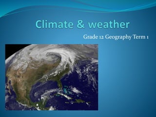
- 1. Grade 12 Geography Term 1
- 2. Chapter 1 : Mid-latitude cyclones
- 3. 1. Global air circulation • Atmospheric Pressure – Pressure exerted by the weight of the atmosphere on the earths surface. • Isobars – Lines on a weather map joining places of the same air pressure. • Hectopascals (hPa) – Unit of measurement for air pressure.
- 4. • An area where the atmospheric pressure is lower than that of the surrounding area. • Low pressure systems are associated with warm air and atmospheric lifting. • This lifting normally produce clouds, precipitation and unstable conditions. • A low pressure cell is called a cyclone or a depression, air moves in a clockwise direction around a cyclone in the Southern hemisphere.
- 6. • An area where the atmospheric pressure is higher than that of the surrounding area. • Highs are associated with cooler, subsiding air(sinking). • Highs normally produce clear (cloudless) dry, stable conditions. • High pressure cells are called anticyclones, air moves anti-clockwise around a anticyclone in the Southern hemisphere.
- 9. 1. Equatorial low pressure belt (ITCZ) 0 ̊ • At the equator warm air expands & rises in convection currents • This causes a belt of low pressure. • This low pressure belt is also called the ITCZ (Intertropical Convergence Zone. 2. Subtropical high pressure belt (30 ̊ n 30 ̊ s) • As hot air rises from the ITCZ, the air temp reaches the same temp as the surrounding air and stops rising , the air spreads (diverges) towards the poles. • The air begins to sink, as it sinks towards the Earths surface it creates an area of high pressure.
- 10. 3. Subpolar low pressure belt • At the North & South pole cold air sinks causing a belt of high pressure and air diverges • At 60 ̊ N & 60 ̊ S, the cold polar air converges with the warm air from the subtropical high, causing the subpolar low. • Combined these 3 pressure belts cause 3 main cells : 1. The Hadley Cell 2. The Ferrel Cell 3. The Polar Cell
- 11. • Pressure gradient – difference in atmospheric pressure across the earth’s surface. • Closer the isobars are together the stronger the wind, the further apart the isobars, the gentler the wind. • Air moves from a high pressure to a low pressure, the air is deflected , and changes direction, this is called Coriolis force (rotation of the Earth) • Earth’s rotational speed is faster at the equator than at the poles, due to this a wind that blows from the equator towards the poles will have a greater speed • Ferrel’s law states: air is deflected to the left in the SH and to the right in the NH. • Coriolis force is zero at the equator.
- 12. 1. Primary Air circulation: • This is the movement of air on a global scale • Examples would be the Tri – cellular module, the Hadley, Ferrel and Polar cell. • These cells are caused by : 1. Convergence zones – areas where air moves in towards an area of low pressure 2. Divergent zones – areas where air moves out from an area of high pressure.
- 16. 2. Secondary air circulation: • The movement of air on a smaller scale, examples • Tropical easterlies • Westerlies • Polar easterlies
- 17. Cross section of tri-cellular model
- 18. • Movement of air on a small or local scale, example: • Berg winds/anabatic/katabatic /on/off-shore winds
- 20. • Mid – latitude cyclones develops at the Polar front between 35 & 60 degrees N or S. • This separates the warm sub-tropical air mass moving east from the cold polar air mass moving west. • Friction between the two moving air masses causes turning and a wave develops
- 22. • Mid-latitude cyclones are also called frontal depressions or extra-tropical cyclones. • The move from west to east, because they occur in the westerly wind belt. • Mid-latitude cyclones move in a clockwise direction around the centre of the low pressure in Southern Hemisphere. • They occur in families of 3 or 4. • They consist of warm and cold fronts • Winds blow into the low pressure. • They cover large areas, 1500km to 3000km and can move at around 1200km per day. • They last about 5 days, however the travel in families and cold wet weather can last for weeks.
- 23. Activity 2 page 71 Q1 Activity 3 page 72 Q1+2
- 24. Stages of a Mid-latitude cyclone
- 25. 1. Initial stage 2. Development stage 3. Mature stage 4. Occluded stage 5. Dissipating stage
- 26. • The Polar front divides the cold polar air from the south (polar easterlies) from the warmer mid latitude (westerlies) • There is no movement of air between the air masses at this stage. • The two air masses don’t mix due to their different characteristics. (cold air is heavy and dense) (warm air is light and less dense)
- 27. • Disturbances can be initiated by an acceleration of air movement in one of the air masses, due to the shape of a coastline, mountains or difference in landsea temps. • This will result in a rotary air movement and a wave will develop.
- 28. • Well developed warm and cold fronts are seen. • Cold fronts have teeth and warm fronts have semi circles, they face the same direction of movement (west to east) • At the warm front, air rises gently over the cold air ahead of it. • These fronts divide the area into warm and cold sectors. • At the cold front, cold air wedges underneath the warmer air causing the warm air to rise rapidly • Isobars bend as they cross fronts, the greater the temp difference between air masses the steeper the angle. • The air mass behind a front will assume its characteristics (air behind a cold front will be cold)
- 30. • The cold front catches up to the warm front, due to the cold front moving faster as it only moves horizontally, the warm front is slower because it moves vertically and horizontally. • Warm air is lifted off the ground and the cyclone starts to die out.
- 31. • All warm air is displaced only leaving cold air at the surface. • All pressure differences are reduced.
- 33. Activity 4 page 75 Q1 TO 3
- 34. Cross section of a mid-latitude cyclone
- 35. Weather patterns associated with cold, warm & occluded fronts.
- 36. 5.1 Mid-latitude cyclone 5.2 West to East 5.3 1. Clear cold and warm fronts have developed, isobars are closer together indicating strong winds, clear warm sector 5.4 Strong winds, heavy rainfall 5.5 Moderate winds, coastal low creating unstable weather conditions along the East coast. 5.6 MLC create damage to dunes and various other vegitation due to gale force winds and destructive waves. 5.7 Important as it will bring rain 5.8 Cross section mature stage.
- 37. Cold front weather conditions: • Strong winds • Change in wind direction • Decrease in temp • Cumulonimbus clouds • Heavy rainfall • Humidity decreases
- 38. Warm sector weather conditions • Temp is at its max • Weathers unsettled / scattered cloud • Wind drops and changes from NW to N direction.
- 39. Warm front weather conditions: • Temp increases • High relative humidity • Nimbostratus clouds • Light rain (drizzle) • Decrease in air pressure
- 40. Cold front Occlusion • Temp in front of the system is higher than behind the system • The cold front cuts the warm front.
- 41. Warm front occlusion • Temp in front of the system is lower than behind it. • The warm front cuts into the cold front.
- 43. • On synoptic weather maps there are lines called isobars. • Isobars join points of equal pressure • Pressure is measured in hPa (hectopascales) • Isobars form patterns, indicating low or high pressure cells • Low pressure cells, the pressure DECREASES towards the middle. • High pressure, the pressure INCREASES towards the middle.
- 44. Reading a weather station
- 45. • Temperature and dew point are in degrees Celsius. • Temp is the TOP number, due point temp in the BOTTOM number. • Precipitation is shown by a symbol below the wind direction/speed. • Wind direction is shown by a “stick” pointing in the direction the wind is COMING FROM the arrow is the circle of the station and the wind speed is the arrows feathers. • Wind speed is shown by a line on the “stick” long line is 10 knots a short line is 5 knots. • Cloud cover is shown in eighths inside the weather station circle.
- 47. Identifying summer and winter on synoptic weather maps.
- 48. • Look at the date. (know your seasons) • High temps over land • Low pressure over land • South Indian High Pressure is found south east of SA. • Tropical cyclones.
- 50. • The date (know winter months) • Lower temps over the land • South Indian High Pressure further north and closer to land • Kalahari High Pressure over the land • Cold fronts are present.
- 52. Unit 2 : Tropical Cyclones
- 53. • Occur from late summer – early autumn • Move from east to west ( they form in the tropical easterly belt) • Affect the east coasts of continents. • They dissipate when reaching cooler latitudes or as they reach land (less moisture for energy) • They named alphabetically – the first cyclone of the season will be named with the letter A.
- 54. • The center of the cyclone is called the “eye” and has: • A calm central point. • Light to no winds • No rain • Very low pressure (960 hPa) • A 30 – 50 km area of subsiding air. • High temps (32 degrees) • Towering cumulonimbus clouds
- 55. Cross section of a tropical cyclone:
- 56. • They occur between 5 ° & 30 ° N & S. They do not develop within 5 ° of the equator as Coriolis force is zero. • Develop over warm tropical oceans where temps of +- 27 °c • They form in the following areas: 1. Atlantic Ocean – West Indies, Gulf of Mexico, south & east coast of USA – they are called HURRICANES 2. Indian Ocean – India, Madagascar, Mauritius, Mozambique – they called CYCLONES 3. Pacific Ocean – China Sea & Japan – they called TYPHOONS. 4. Australia – they called WILLY WILLIES or CYCLONES
- 57. Distribution of tropical cyclones
- 58. Activity 8 page 84
- 59. • Warm oceans – late summer due to warm sea temps • Hot air temps – air rises, low pressure develops & the rising air cools & condenses. • Water vapor – to condense and release latent heat to provide energy. (more heat more unstable conditions) • Coriolis force – if low pressures cells develop outside the 5 ° N & S Coriolis force will cause the winds to spiral towards the low pressure cell. Winds blow clockwise in the SH and anti-clockwise in the NH. • Intense low pressure cell – the pressure must be below 1000 hPa • See page 85 – explanation for cyclones continued energy.
- 60. Stages in formation of a TC
- 61. 1. Formative Stage • A low pressure cell develops • Pressure is still above 1000 hPa
- 62. 2. Immature Stage • Pressure decreases to below 1000 hPa. • Gale force winds develop. • Air circulation is clockwise (SH)
- 63. 3. Mature Stage • Pressure at its lowest > 960 hPa. • Hurricane force winds & heavy rain • Worst weather is in the forward left hand quadrant.
- 64. 4. Degeneration Stage • Pressure increases • Decrease in wind speed but heavy rain continues. • Dissipates over land or when it reaches high pressure cells
- 66. Weather associated with TC
- 67. • Cyclones cover areas up to 500km, different weather is experienced in each part. • The eye is the center and the eyewall are the sides of the eye. 1. The eye • Hot, humid and calm weather caused by the warm descending air mass (LP) 2. The eyewalls • Rapid uplift of air, fall in temp to due point, 100km thick cumulonimbus clouds develop up to 15 km high. • Heavy rain, flooding • Storm surge – causes the very high seas due to high winds causes flooding 3. Beyond the eyewall • Dense cirrus, altostratus & cumulus clouds extend for 100’s of km resulting in heavy rain.
- 68. 1. Storm Surge – water pushed towards shore combing normal tides to increase water levels to 4.5m or more. 2. Inland flooding – torrential rain causes flooding which results in damages to infrastructure, death to people/livestock and loss of agricultural land. 3. Flash flooding – due to torrential rain, flash flooding can occur causing similar damage as point 2.
- 69. Activity 10 page 89
- 70. Synoptic weather maps & cyclones
- 71. • A (LP) cell with circular pattern of isobars between 5° s & 30° s with a very steep pressure gradient • Date with be late summer / early autumn • This symbol will be in the eye • The name of the TC will be printed along side the eye.
- 72. Activity 11
- 73. Case study TC Funso pg. 92
- 74. Short term effects: • Wind & Rain destroy homes & buildings • Water sources become polluted and diseases spread • Bridges & roads are destroyed cutting off access for emergency personal • Power lines go down • Flooding causes crops & livestock damage Long term effects: • Water supplies get contaminated when sewage systems are destroyed. • Large scale soil erosion removes valuable top soil
- 75. The following are ways to prepare and lessen the impact: 1. Weather stations can identify & predict the path of TC & issue warnings. 2. Disaster management centers have been set up to provide AID – water/food/money 3. Prepare the communities with having evacuation drills & procedures. 4. Land use planning – limit development in coastal areas
- 76. Chapter 3: Subtropical anti-cyclones
- 77. 1. South Atlantic High 2. South Indian High 3. Kalahari High High pressure cells are also called Anticyclones
- 78. Location of the 3 HP Cells in SA
- 79. Why are these HP Cells there?
- 80. • Anticyclones are associated with DESCENDING air. • They cause clear skies and no rain. • Air circulation is anticlockwise in the SH. • Anticyclones move northwards in winter and southwards in summer in the SH. • During summer these cells are weaker due to warm surface air rising, and in winter they stronger due to cool air descending.
- 81. In winter all 3 HP cells are further north. Reason being its summer in the Northern hemisphere and this causes a heat distribution & pressure belts to shift north. SAH & SIH are closer to the coastline, they now have less time to travel across oceans to bring moisture therefore less rain. Due to HP cells further north, this allows for Mid- latitude cyclones to move closer to land.
- 82. Winter in the SH
- 83. Winter the interior get clear skies, sunny days with no rain. Temps range from freezing to high twenties. Droughts are evident The Kalahari HP influences the following: • Dry very cold air immediately above the plateau. • Dry air from the KHP warms as it subsides.(Adiabatic) • Above the plateau there is a layer of warm air called the inversion layer, rising air cant penetrate this inversion layer. • Warm moist air from the Indian ocean cant blow onto the plateau as it to is blocked by the inversion layer, this is what causes the droughts.
- 85. • In summer the SAH and SIH move southwards. • They move further away from the coastlines, winds blowing out these anticyclones have a further distance to travel over the sea before they reach land. • Winds blowing out the SIH travel across the warm Mozambique current and picks up moisture. • This moisture brings rain to the eastern coastline. • Winds blowing from the SAH travel over the cold benguela not picking up much moisture and the western coastline remains dry.
- 87. Summer in the SH
- 88. In summer the KHP rises by 500m, it doesn't disappear you sometimes just wont see it. Normally the interior is dominated by a LP, this LP results in the inversion layer rising. The rising of the inversion layer allows warm moist air from the Indian ocean to move onto the interior bringing rain in summer.
- 89. • In summer the SAH anticyclone moves south. • It elongates to form a ridge south of the country • This produces strong southeasterly winds over the Cape. • This wind can be funneled through mountains and streets on land causing gale force winds.
- 91. Activity 15 pg. 100
- 92. • Some weather patterns that arise with the South Atlantic, South Indian and Kalahari anticyclones only occur at certain times of the year, and travel to different areas. • This is called a travelling disturbance. • We will look at the following : 1. Moisture front 2. Line thunder storm 3. Berg winds 4. Cut off low
- 93. 1. Moisture front & line thunderstorms
- 94. • A moisture front is formed at the convergence zone of air masses from the Atlantic and Indian ocean • The South Atlantic High Pressure brings SW winds from the Atlantic Ocean, this air is cold and holds little moisture, the Atlantic is cold due to the Benguela current, so cold, dry air is fed onto the land from the west. • The South Indian High Pressure brings NE winds from the Indian Ocean, this air is warm and moist, the Indian Ocean is warm due to the Mozam current so warm, moist air is fed onto the land from the east.
- 95. • The cold, dense Atlantic air (SW) wedges underneath the warm, moist Indian air (NE), forcing it upwards. • This results in a moisture front and causes convection clouds to develop. • This moisture front brings a line of thunderstorms and heavy rainfall over central parts of SA.
- 96. • Coastal lows develop along the west coast of SA and move eastwards. • They found during autumn and winter. • Air circulation is clockwise into the low, this causes onshore flow behind the coastal low, this brings clouds and fog. • Ahead of the coastal low is offshore flow, this causes clear warm weather, this could create a fire hazard.
- 98. Berg winds occur in winter. Cold front will occur directly after a berg wind has blown. Berg winds occur along the east coast towards KZN. Formation of berg winds Winter there’s a high pressure over land, with an approaching low pressure & cold front off the coast line. This causes a strong pressure gradient when the LP meets the KHP. Winds will blow from the HP to the LP. (causing a coastal low) Winds blowing from the mountains (HP) to the coastline (LP) will heat up adiabatically and cause very hot and dry conditions at the coastline.
- 99. Berg winds
- 100. • At times the SAH forms a strong ridge behind a cold front, blocking or cutting it off. • This causes cold, moist air to flow southwest behind the cold front. • Very cold weather with heavy rain and snow can be experienced with a cut off low.
- 101. Cut off low
- 102. Microclimates
- 103. Key terms: Microclimate – climate of a local area. Slope aspect – angle at which the sun’s rays strike a slope. Shadow zone – area of a slope which receives no direct sun
- 104. 1. Slope aspect: • Depending on the season the suns rays will strike the Earths surface at different angles. • In summer the angle will be greater than 90 ° • In winter the angle will be less than 90 ° • This will play a role in temp of the valley • Summer the rays are more direct and heat a smaller area. • In winter the suns angle will be lower creating an oblique angle having to heat up larger areas.
- 105. In the Southern Hemisphere the slopes facing the north are warmer due to the sun’s rays being more direct. South facing slopes are cooler, due to the sun’s rays strike at a more oblique angle. See figure 2.56 & 2.57
- 106. Key terms: Anabatic winds – blow up the sides of a valley during the day Valley – blow during the day up the length of the valley from the bottom to the top. Katabatic winds – blow down the sides of the valley at night Mountain – blow at night down the length of the valley from the top to bottom.
- 107. • Valley slopes will heat up quicker than the valley floor due to aspect. • This creates a pressure gradient between cool air (valley floor) HP and the warmer air (valley slopes) LP. • HP will move to a LP creating the upward flow of air and the upslope wind.
- 108. • By midday the air has been heated at the valley floor. • The top of the valley is narrower and air heats up faster this causing a lower pressure to the bottom cooler air. • The cooler (HP) air from the valley floor moves up the valley towards the warmer (LP) at the top of the valley. • This creates the valley winds.
- 109. • At night the valley slopes cool rapidly due to terrestrial radiation. • The cold air drains down the sides of the valley to form katabatic winds.
- 110. • At night the air in the upper more narrow part of the valley cools quicker than the bigger air mass at the bottom. • This air at the top becomes dense and heavy draining to the bottom of the valley to form a katabatic / mountain wind
- 111. • On clear, windless nights the air on the high ground “slopes "cools very quickly due to terrestrial radiation. • This creates katabatic winds and the cold air sinks and displaces the warmer air at the bottom of the valley. • This cold air pushes the warmer air up to create a thermal belt mid way up the valley. • This warmer air meets cooler air above, due to air subsiding air above the valley • This causes a temperature inversion layer (temp increases with height.)
- 113. When air cools the temp can fall below dew point. If dew point is below freezing, water will condense into ice crystals and cause frost on the valley floor. This is known as a frost pocket.
- 114. • Fog caused by air cooling to dew point as a result of terrestrial radiation. • In mornings the sun penetrates the fog to heat up the valley floor below it this causes the fog to lift.
- 115. 1. Vegetation and farming Slope aspect plays a big role in the type of vegetation one will find on “sun facing slopes” and “non sun facing slopes” In the SH the vegetation and soil is dryer on the North facing slope due to more sun and evaporation. Grass and succulents will grow on the “sun facing slope” Certain crops like vines for grapes like hot , sunny conditions so wine farmers will plant vines on the north facing slopes in SA. Some crops cant handle frost so farmers will not plant them in the valley but rather further up the valley sides.
- 117. • People will build houses / huts etc. on the “sun facing slopes” • This will ensure sun shining into their houses for most of the day.
- 118. Act 20 & 21
- 119. Urban climates
- 120. 1.1 Temperature variations • Cities are warmer than surrounding rural areas because: Cities are built with artificial substances which absorb more heat than natural features. Cities have artificial sources of heat cars, power plants even people emit heat. Cities have less ground water as most of it will be carried away by drains, there are also fewer plants. High rise buildings absorb heat from the sun. Cities have pollution slowing down cooling at night, the pollution acts as a blanket.
- 121. • Due to less water in cities, there is less humidity as humidity is the amount of water vapour in the air, water is carried away by storm water drains and less plants. • Precipitation (fog, mist, cloud, rain, snow, dew) is greater over cities, this is due to more condensation nuclei present (dust, smoke and other pollution) this helps to increase condensation and more precipitation. • Thunderstorms are more frequents as there is more heat with stronger upward convection currents.
- 122. Urban Heat islands An urban heat island is when the central part of the city is warmer than the surrounding suburban and rural areas.
- 123. Urban heat island during the day time • During the day: Hot air rises above a city and cool air moves in from the surrounding suburbs & rural areas. The warm polluted air rises over the city so a heat island mushrooms over the city. The heat island is a dome shaped cushion of warm air over the city because the dominant air pressure over the region is anticyclonic (HP) This results in warm subsiding air, stopping the warm polluted air from rising up into the atmosphere.
- 124. Urban heat island at night time • At night: City surfaces lose heat faster at night than surrounding rural natural surfaces. The city cools at night, therefore upward – moving air currents are not as strong The dome shaped island becomes smaller at night. Temp differences are not so great, making air movement less. Pollution is more concentrated at night creating a pollution dome.
- 126. What is a pollution dome? It’s a mass of polluted air in and above a city that’s prevented from rising by the presence of an inversion layer. What causes pollution domes? People in cities release waste products into the air such as nitrous oxide and various other gases, the main sources of pollution in cities are: Vehicles Burning of fossil fuels. What are the effects of pollution domes: o Health problems – lung infections o Acid rain – damages natural features and man-made features
- 127. • Winds greater than 20km/h will cause pollution domes to dissipate. How can we reduce the heat in cities? 1. Change dark surfaces to light reflective surfaces - like roofs dark roofs can be up to 21 degrees hotter than white ones. Use concrete and not tar. 2. Greening – planting trees, in gardens along roads in parks, this will shade cities and increase transpiration, which decreases air temps. In CBD’s we need to plant roof top gardens, this will cool buildings down.