
Recommended
More Related Content
What's hot
What's hot (20)
Similar to Rivers of Goa
Similar to Rivers of Goa (20)
Recently uploaded
Recently uploaded (20)
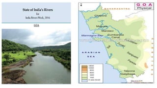
Rivers of Goa
- 3. Zuari River
- 4. • Zuari River is the largest river in the state of Goa, India. It is a tidal river. The river originates at Hemad-Barshem in the Western Ghats. The Zuari River is also referred to as the “Aghanashani” in the interior regions of Goa. Zuari is 92 km long, but is connected to other rivers and canals such as Mandovi River and Cumbarjuem Canal. The waters of the Mandovi and Zuari both flush out into the Arabian Sea at Cabo Aguada, a common point forming the Mormugao Harbour. Vasco Da Gama, the port city of Goa lies on the mouth of Zuari River. • The Zuari along with the Mandovi River are the backbone of the economy and these along with their tributaries traverses a major portion of the state. The Zuari and Mandovi Rivers form an estuarine system. The banks of the Zuari River are covered with mangrove trees and are a perfect destination for adventure lovers. Crocodiles inhabit in the swampy and marshy area, which can be easily spotted while travelling in river cruises. • Course of Zuari River • The Zuari River flows in the south-western direction through the Quepem, Salcete, Ponda, Mormugao and Tiswadi taluks and finally evacuates into the Arabian Sea, around the Mormugao harbour. It merges with the Talaulim stream, at the town of Sanguem. It is in this town that the river widens and accepts waters from its tributary, Kushavati. • Zuari River Bridge • The famous Zuari Bridge built over the lengthy Zuari River connects North and South Goa and is the busiest bridge. The Zuari River also serves as a conduit for navigation of ore-laden ships into the hinterland.
- 5. The Mahadayi/Mandovi River, also known as Mahadayi or Mhadei river, is described as the lifeline of the Indian state of Goa. The Mandovi and the Zuari are the two primary rivers in the state of Goa. Mandovi joins with the Zuari at a common creek at Cabo Aguada, forming the Mormugao harbour.
- 6. It runs westward into the Arabian sea at Chapora and demarcates the border between the North Goa talukas of Pernem and Bardez. The river originates at Ramghat in the neighbouring state of Maharashtra enters Goa and flows into the Arabian Sea.
- 7. The Sal River is a small river in Salcete, Goa in India. The river opens near Verna and passes through the villages of Nuvem, Mongul, Seraulim, Colva, Margao, Benaulim, Navelim, Varca, Orlim, Carmona, Dramapur, Chinchinim, Assolna, Cavelossim, Mobor and drains itself into the Arabian Sea at Betul.
- 8. The Terekhol River is a river in western India. In its upper reaches it is known as the Banda River and in the lower reaches as the Terekhol. It forms the boundary between Sindhudurg district of Maharashtra state and North Goa district of Goa state for some distance.
- 9. Talpona River : Talpona River originates in the dense, mixed jungles of Ravan Dongor in between Nane and Kuske on the Sahyadri Mountains. It passes through canacona. It comes down by passing Bhatpal, fed by the tributary, also named Bhatpal, and drains into the Arabian Sea near the village of Talpona. The river develops a length of around 31km. It has three other tributaries named Nadke, Gaondongrem, and Khalwade.
- 10. Galgibaga River
- 11. Highest Waterfalls in India • Nohkalikai Falls, Cherrapunji. • Nohsngithiang Falls, Meghalaya. • Kynrem Falls, Meghalaya. • Langshiang Falls, Meghalaya. • Dudhsagar Falls, Goa. • Meenmutty Falls, Kerala. • Thalaiyar Falls, Tamil Nadu. • Jog Falls, Karnataka.
- 12. Mayem Lake
- 13. Carabolim Lake
- 14. Curtorim Lake
- 15. Drainage •In geomorphology, drainage systems, also known as river systems, are the patterns formed by the streams, rivers, and lakes in a particular drainage basin. They are governed by the topography of the land, whether a particular region is dominated by hard or soft rocks, and the gradient of the land.