1. U.S. Department of the Interior
U.S. Geological Survey
Fact Sheet 2011–3009
Version 2.0, May 2015
Historical Topographic Map Collection
Scanning and Georeferencing Historical USGS Quadrangles
The U.S. Geological Survey (USGS)
National Geospatial Program is scanning published
USGS 1:250,000-scale and larger topographic
maps printed between 1884, the inception of the
topographic mapping program, and 2006. The
goal of this scanning, which started in 2011, is to
provide a digital repository of USGS topographic
maps, available to the public at no cost. For more
than 125 years, the USGS topographic maps have
accurately portrayed the complex geography of
the Nation. The USGS is the Nation’s largest
producer of printed topographic maps, and, prior to
2006, USGS topographic maps were created using
traditional cartographic methods and printed using
a lithographic process. As the USGS continues
release of a new generation of topographic maps
(US Topo) in electronic form, the topographic map
remains an indispensable tool for government,
science, industry, land management planning,
and leisure.
When physical and cultural features change
over time, maps are updated, revised, and new
editions printed. Although they are technically
out of date, these historic maps are often useful
to scientists, historians, environmentalists,
genealogists, and others researching a particular
geographic location or area. A series of maps of
the same area published over a period of time can
show how some areas looked as early as 1884,
before current development, and provide a detailed
view of changes over time.
Because historical maps are stored in a
limited number of collections and are not readily
available, the USGS National Geospatial Program
is converting these historical printed topographic
quadrangles to an electronic format (GeoTIFF and
GeoPDF). This serves the dual purpose of creating
a master catalog and digital archive copies of the
irreplaceable collection of topographic maps in the
USGS Reston Map Library, as well as making the
maps available for viewing and downloading from
the USGS Store and The National Map Viewer.
Historical Topographic Map Benefits
Building a comprehensive historical collection
of topographic maps requires accurate cataloging
and creating metadata (complete information about
“A government cannot do any scientific work of more value to the people at large
than by causing the construction of proper topographic maps of the country.”
John Wesley Powell to Congress, Dec. 5, 1888
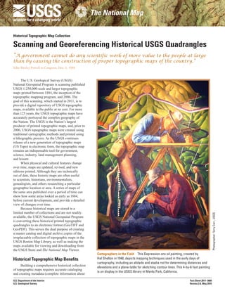
Cartographers in the Field This Depression-era oil painting, created by
Hal Shelton in 1940, depicts mapping techniques used in the early days of
cartography, including an alidade and stadia rod for determining distances and
elevations and a plane-table for sketching contour lines. This 4-by-6 foot painting
is on display in the USGS library in Menlo Park, California.
Photographer:TerryCarr,USGS
2. By L.R. Davis and G.J. Allord
1884 map from Massachusetts The first
State to participate in the Cooperative
Topographic Mapping Program.
each map) to accompany high-resolution,
georeferenced digital files representing the
lithographic maps. Georeferencing in the
digital file allows basic map analysis to be
done, such as pointing and clicking on the
map to determine distance, area calculation,
coordinate points, and other information.
Each map image is scanned “as is” and
captures the current content and condition
of each one. The collection provides ready
access to maps that are either no longer
available for distribution in print or are
being replaced by the new generation of
US Topo maps. Georeferencing of the
map files—that is, tying them to a known
earth coordinate system—enables them to
be imported into geographic information
systems so that they can be overlain with
other geospatial (map) data from other
sources, such as from The National Map.
The potential for research that analyzes
change over time is becoming increasingly
recognized by the geospatial community,
and this project provides published
lithographic USGS maps in georeferenced
digital formats. With georeferencing, the
historical maps can be combined with
current data from The National Map. The
product will be delivered as GeoTIFF
images with embedded metadata.
The scanned historical maps will
also be available for general reference and
viewing in a compressed GeoPDF format.
These files can be viewed and printed
as PDF documents with a wide range of
software. Using the geospatial extension
requires Adobe Acrobat Reader with the
no-cost TerraGo Toolbar for Microsoft
Windows. GeoPDF files are accessible
using all browsers for downloading at the
USGS Store Web site (http://store.usgs.
gov/). These GeoPDF files will continue
to be added to the USGS Store as they
become available.
The USGS National Geospatial
Program is:
• Developed and published specifications
for scanning maps.
• Developed methods to efficiently create
accurate, high-resolution, scanned
georeferenced images.
• Created a catalog and metadata for all
historical topographic maps that have
been scanned and published in electronic
form by the USGS.
• Provided historical paper maps in
electronic form to support the new
generation of electronic topographic
maps (US Topo).
• Archived published files with the
National Archives and Records
Administration and the Library
of Congress.
• Provided publicly accessible,
downloadable, and viewable files
of approximately 200,000 scanned
maps, complete with metadata that is
compliant with the Federal Geographic
Data Committee.
Future Plans
• As they are identified, scan and release
historical USGS quadrangles that are
not currently electronically available.
• A GeoTIFF product has been designed
and the release of historical quads as
GeoTIFF files will begin in early 2015.
For More Information
To view and download information
about The National Map, go to
www.nationalmap.gov. To contact the USGS
concerning The National Map, go to http://
www.usgs.gov/ask/ or email nationalmap@
usgs.gov.
For information regarding the Historical
Topographic Map Collection, go to
nationalmap.gov/historical.
Scale 1:62,500
Printed in 1886
ISSN 2327-6932 (online)
http://dx.doi.org/10.3133/fs20113009