
Recommended
More Related Content
What's hot
What's hot (20)
Similar to Unit 2 (part 2): Landform
Similar to Unit 2 (part 2): Landform (20)
More from Gema
More from Gema (20)
Recently uploaded
Recently uploaded (20)
Unit 2 (part 2): Landform
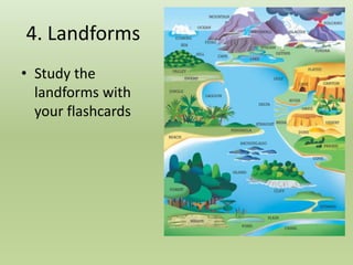
- 1. 4. Landforms • Study the landforms with your flashcards
- 3. Crust and Oceanic Relief
- 5. Crust and Oceanic Relief • Continental Crust: is the part of the crust that forms the continents (including the coastal areas called continental shelves). • Continental Shelf: is the part of the continental crust that is under the sea. • Continental Slope: sharp decline that connects the continental crust and the oceanic crust. • Oceanic Crust: is the part of the crust that is under the sea. • Abyssal Plain: it is an undersea plain. It is between 3000 and 5000 metres of depth. • Mid-ocean ridge: it is an undersea mountain range. (The average elevation is 2000-3000 metres). • Oceanic trench: it is a long depression under the sea. Here the oceanic crust goes under the continental crust.
- 6. • Glacier: accumulation of ice in cold regions. It can be accumulated in a region like the poles or it can move very slowly through a valley. • Mountain: is an area of land higher than the surrounding land. • Plain: is a flat area with an altitude under 200 m. • Plateau: is a flat area with an altitude over 200 m. • Valley: is a low area between hills usually with a river running through it. Landforms
- 7. Coastal landforms • Inlet: is an entrance of the sea into the coastline. E.g. gulf, bay, estuary, fjord… • Outlet: is a projection of the coast into the sea. E.g. cape, delta, headland… • Gulf: is when the sea enters into the coastline forming an enclosed area of sea. • Cape: is a piece of land that projects into the sea. • Island: is an area of land completely surrounded by water. • Isthmus: section of land that connects two larger areas. • Peninsula: is an area of land surrounded by water on all sides except one.
- 8. River and types of mouths • River: is a continuous current of water. Types of mouths • Fjord: is a valley of a glacier that is inundated by the sea. It has steep sides or cliffs. • Ria: is a valley of a river that is inundated by the sea. • Delta: Accumulation of sediments at the mouth of a river. • Estuary: mouth of a river where the sea enters into the river.
- 12. Delta of Nile river
- 13. Delta of Ebro river
- 14. Estuary of Tagus river