SlideShare a Scribd company logo
1 of 53
OCEANS-TEMPERATURE
INTRODUCTION
• Oceanography is the branch of Physical Geography which studies about
the distribution of oceans in world.
• 71% of earth surface is covered by water and 29% is by land.
• As a maximum of earth surface is covered by water, it is called a Blue
Planet.
• Distribution of oceans is more in southern hemisphere as maximum
portion of northern hemisphere by land.
• There are five oceans i.e. Pacific Ocean, Atlantic Ocean, Indian ocean,
Arctic Ocean and Antarctica. The largest ocean among all this Pacific
Ocean.
Hydrological Cycle
• Water moves in a continuous cycle and changes from one form to
another.
• Water from the surface of earth evaporates on heating ad changes
from liquid to gas. This process of change of water vapour from
liquid to gas is called evaporation.
• Water vapour is carried by the air to a particular height where
condensation of water vapour takes place and result in forming
clouds. This process of change of water vapour from gas to solid is
called Condensation.
• When the cloud is not able to hold the condensed water vapours,
they fall on the surface of Earth in form of rain, snow etc. This
process of falling of water vapour on surface of earth in form of
rain or snow is called precipitation.
• This continuous interchange of forms of water on surface of earth
is called Hydrological Cycle.
Temperature of Ocean water
• Ocean water temperature increases when it receives
insolation from sun. Temperature of ocean water is not same
rather it varies from place to place and time to time.
• Various factors affecting ocean water temperature are:
• 1. Latitude: temperature of ocean water is more near to
equator and less at poles. It is because of more heat
received by the sun near equator as compared to poles.
• 2.Winds: In difference in temperature and pressure
conditions result in movement of wind from one area to
another. Warm winds increases the temperature of the region
it passes and and cold wind decreases the temperature of the
region it passes.
• 3.Ocean currrent: Movement of water by wind in a particular
direction is called ocean current. Warm ocean current
increases the temperature of the region it passes like Gulf
Stream and Cold current like Labrador current near Greenland
decreases the temperature of the region it passes.
• 4. Unequal distribution of Land and Sea:
• Distribution of land is more in northern hemisphere
as compared to southern hemisphere. Therefore
oceans in the northern hemisphere like Pacific
Ocean are warmer as compared to oceans in
southern hemisphere like Antarctica.
• 5.Icebergs: Icebergs decrease the temperature
of the ocean water of which they are present.
• 6.Salinity: Oceans with high salinity like
tropical areas have more temperature as
compared to oceans near poles like Arctic
Ocean.
Vertical Distribution of Temperature I
Oceans
• Temperature of oceans is
maximum at surface because of
heat received by the sun. As we
go down the ocean surface,
temperature starts decreasing.
• The region from where there is
certain decrease in temperature
is called Thermocline.
• 90% of total volume of water is
present below thermocline.
• The first layer of Thermocline
ranges between 0-500 metres
with temperature ranging
between 20-25°C. it is present
near tropical areas.
• The second layer of Thermocline
ranges between 500-1000
metres with temperature ranging
between 8-16°C. it is present
near temperate areas.
• The third layer of Thermocline is
very cold and extends upto the
depth of ocean floor.the
temperature ranges between 0-
4°C. it is present near polar
areas.
Horizontal Distribution of Temperature
in Oceans.
• Horizontal Distribution of temperature in oceans is
studied with the help of distribution of land and sea.
• In northern hemisphere distribution of land is more as
compared to southern hemisphere.
• Oceans in northern hemisphere have a higher
temperature like Pacific Ocean as compared to Southern
hemipshere like Antartica.
• Temperature in oceans of tropical zone is 27°C, 14°c in
temperate lattitudes and 0°c near poles.
• The rate of decrease of temperature is 0.5°c per lattitude
in oceans.
• The average temperature for all oceans is 17.2°C.
OCEANS-SALINITY
Introduction
• Salinity refers to presence of
dissolved salts in sea water.
• It is calculated as ppt or parts
per thousand grams of sea
water.
• The average salinity of sea
water is 35 per thousand
grams of sea water.
• Salts Ppt
Chlorine (Cl2) 19
Sodium(Na) 10
Sulphate(SO4) 3
Factors Affecting Salinity
• 1.Temperature: Areas which are
near to equator have high
temperature which result in high
evaporation and adding salts on
ocean surface.
• 2. Fresh Water: Areas which
receive fresh water from rivers
have low salinity. Fresh water mixes
with the water with salts and thus
reduces its salinity.
• 3. Ocean Currents: Warm Ocean
currents carry high saline water to
the area they move and cold
currents carry less saline water to
area they move.
HORIZONTAL DISTRIBUTION OF
SALINITY
• 1. Salinity in Open Seas:
• Open seas are the seas which have access to fresh water.
If open seas are located near to Equator they will have
less salinity because heavy rainfall will increase the fresh
water and decrease the salinity.
• Salinity is also less in polar areas because melting of ice
adds fresh water and help in decreasing the salinity.
• 2 Salinity in partially enclosed seas:
• Partially enclosed seas are the seas which are
partially covered by land and other by sea like
Mediterranean Sea, Red sea and Baltic Sea.
• Mediterranean Sea have high salinity because
of its location in high temperature area which
increases the evaporation rate and absence of
large rivers helps in increasing the salinity in
the area.
• Salinity of Enclosed Seas:
• Enclosed seas are the seas which are covered
from all sides.
• Lake Van in Turkey have 330 ppt as the salinity,
Dead Sea have 24 pt salinity and Great Salt
Lake have 220 ppt salinity.
Vertical Distribution of Salinity
• On the sea surface salinity is increased by high
evaporation and is reduced by the addition of
fresh water.
• More salinity will add more salts to water,
make water more dense. With the increasing
depth the salts keep on depositing and salinity
increases with increasing depth.
• Halocline is the line which help in reflecting
the amount of salinity in the area.
Relief of Ocean Floor
or
Features of Ocean Floor
Introduction
• The ocean floor is not plain as believed.
• Floor of various oceans have complex mountain ranges,
trenches etc.
• Tectonic plates movement, volcanic erruptions inside
oceans, depositional or erosion of material by sea waves
has resulted in its formation.
• The various features of ocean floor are:
• 1. Continental Shelf
• 2.Continetal Slope
• 3.Oceanic Deeps or Trenches
• 4.Abyssal Plains
• 5. Submarine Ridges
• 6.Abyssal Hills
• 1.Continental Shelf:
• It is the gentle seaward sloping surface extending
from coast towards open sea.
• It is formed by sediments brought down by rivers,
wind, waves etc.
• It covers 7.5% of total area of worlds ocean.
• It have a gentle slope 1°C and depth is normally
200 mts.
• Importance of Continental Shelf:
• Sun’s rays can’t penetrate upto Continental Shelf
which encourages growth and reproduction of
marine organisms.
• Marine food comes from this part of ocean floor.
• Provides richest fishing grounds.
• Storehouse of various minerals like petroleum and
natural gas.
• It is also storehouse of sand , gravel etc.
• 2.Continental Slope:
• It is the steep slope separating a continental
shelf and a deep ocean basin.
• The gradient of slope varies between 2-5°
• The depth of the slope is between 200-3600
mts.
• 3.Oceanic Deeps or Trenches
• These are deepest part of the oceans.
• They occur at the base of continental slope.
• They are long, narrow and deep in nature.
• They extend upto 5500 mts
• They are formed by the folding and faulting of the Earth’s
Crust.
• Mariana trench is the deepest trench of the Pacific Ocean.
• 4. Abyssal Plains
• These are also called as Deep Sea Plains.
• They are flat and smooth in nature.
• These plains are covered with fine sediments like
clay, silt etc.
• They are cover 40% of the ocean floor.
• they depth vary between 3000-6000 mts
• They are present in all major oceans and seas in
world.
• 5.Submarine Ridges:.
• It consist of various underwater mountain ranges
in sea.
• It is spread over thousand kilometers longs
• It is formed by converging or diverging of the
plates.
• They form the longest mountain system under
the Earth.
• Mid Atlantic ridge in Atlantic Ocean is the
example of Submarine Ridge.
• 6.Abbysal Hills:
• There are thousand hills inside the ocean floor. Various
hills are Sea Mount and Guyots.
• A)Sea Mount:
• It is the mountain peak which is rising from the ocean
floor but they are not reaching the ocean surface.
• They are of volcanic origin.
• They can be 3000mts to 4500 mts.
• Example Hawaiian Islands in Pacific Ocean in Japan
• B)Guyots:
• The flat bottomed sea mount is called Guyot.
• It is volcanic origin.
• Erosion of sea mount by various agents like
water, waves give this feature.
• Example: Hawaiian Sea Guyot in Japan.
OCEAN -WAVES
Introduction
• Ocean water is never static but keeps on moving
horizontally or vertically. The horizontal motion
refers to ocean waves and currents and vertical
motion is called tides.
OCEAN WAVES
• The movement of water due to energy produced by
wind is called Wave.
• A thing is floating up and down but it is carried by
the wind in a particular direction.
• As wave approaches the beach, it slows down. This
is due to friction between water and surface.
• The size of waves depend upon following factors:
• 1. Velocity of Wind: More the velocity of wind,
more will high will be the wave.
• 2.Duration of Wind: if wind moves a longer
duration of time, more waves will be formed.
• 3.Distance (Area) over which wave is moving:
• If wave is moving over an area with more speed,
long time, and over an area which does not stops it
then more high wave will be formed.
Terms associated with Waves:
• Crest: The upper part of the wave
is called Crest.
• Trough: the lower part of the wave
is called trough.
• Wavelength: The distance
between Crest and Trough is called
Wavelength.
• Waveheight: vertical distance
between Crest and Trough is
called Wave height
• Wave amplitude: Half of the wave
height is called Wave amplitude.
• Wave frequency: the number of
waves passing a given point during
one second time interval is called
wave frequency.
OCEAN -TIDES
OCEAN-TIDES
• The periodic rise and fall of sea level due to
gravitational attraction of sun and moon acting on
Earth is called tides.
• It occurs twice a day after 12 hours 26 minutes.
• The rise of sea level is called high tide or flood tide
and fall is called low tide or ebb tide.
ORIGIN OF TIDES
• 1.Gravitational pull of Sun and Moon
• Water of Earth is held in position by its own gravity but
gravitational pull of moon and sun acts on it.
• Due to large size of the sun, sun is attracting more but at large
distance it is not able to have more gravitational force.
• Moon’s size is low but its near to Earth so gravitational pull is
more
• 2. Centrifugal Force: It is force applied moving in
circular orbit. It moves from centre to outside.
• 3. Tide Generating Force:
• Difference between centrifugal and gravitational
pull of moon.
Types of Tides
• 1.On basis of frequency:
• 1.Semi-diurnal Tide: When there are two high and
two low tides in a day. But tides are of same height.
• 2.Diurnal Tide: There is one high tide and low tide
but the tides are of same height.
• 3. Mixed Tide: Tide having variations in high and
low tide is called Mixed tide.
• 2. On basis of Position of Earth, Moon and Sun.
• 1. Spring Tide:
• When Sun, Moon and Earth are in straight line,
they exert combined gravitational pull on Earth.
Therefore on both days tides are high.
• 2. Neap Tide:
• When Sun, Moon, Earth are at right angle it is
called Neap tide.
• Attraction of Sun and Moon tide to balance each
other as a result of which low tide is formed.
• When moon orbit is near to Earth it is called
Perigee and when moon is farthest from Earth
it is called Apogee.
Importance of Tides
• 1.Tidal force can be used for generating
electricity. Example in India, Gujarat Gulf of
Kuchch and Khambat have high potential.
• 2. Tides keep sea water in motion and avoids its
freezing.
• 3.tides leave shells and other sea products on
shore.
• 4. Fishermen go to open sea for catching fish on
high tide and come back on low tide.
• 5. Tides help in making river water navigable.
OCEAN CURRENTS
Meaning of Ocean Currents
• Regular movement of water in a particular
direction is called ocean currents.
Factors responsible for origin of
currents:
• 1. Temperature difference: At the Equator,
temperature is high and the water also becomes
light on heating. At the poles, the temperature is
low and water becomes dense. Difference in
temperature is also one the cause of movement
of water from polar areas to equator.
• 2. Prevailing Winds: Winds move in area due to
indifference in temperature conditions. When
winds blow in a particular direction and take the
water along is called ocean currents.
• 3.Evaporation: More evaporation reduces the level
of water and water moves from surrounding area to
balance the level of water.
• 4. Rotation of Earth: Due to rotation of Earth,
coriolis force becomes active because of which
winds move right in northern hemisphere and left
in southern hemisphere. Winds carry the water also
in its direction and give birth to currents.
• 5.Salinity differences: Water having high salinity is
denser and thus moves down. Light water with less
salinity moves toward it and a current is formed.
Example : Mediterrenean Sea have highest salinity
which thus causes to water move from Atlantic
Ocean.
TYPES OF OCEAN CURRENTS
• 1.ON THE BASIS OF DEPTH
• 1.SURFACE CURRENTS: The currents which are
prevalent over the surface of water. They
constitute over 10% of all water in the ocean.
• 2.DEEP WATER CURRENTS:
• When the water is carried by wind due to various
differences like salinity, density deep in the
oceans is called DEEP WATER CURRENTS. They
constitute 90% of total ocean water.
• 2. ON THE BASIS OF TEMPERATURE
• 1.WARM CURRENTS:
• The currents which move from warm areas of
tropics to cold areas of polar latitudes is called
warm currents. They increase the temperature of
the area to which they go. Example: Gulf Stream is
a warm current in Atlantic Ocean.
• 2. COLD CURRENTS:
• The currents which move from cold areas to warm
areas is called Cold Currents. There temperature is
lower so they decrease the temperature of the
area they go. Example: Canaries current is a cold
current.

More Related Content

What's hot

What's hot (20)

Temperate Cyclones
Temperate CyclonesTemperate Cyclones
Temperate Cyclones
 
Climate of india
Climate of indiaClimate of india
Climate of india
 
Ocean currents
Ocean currentsOcean currents
Ocean currents
 
Ocean tides, types and theories
Ocean tides, types and theoriesOcean tides, types and theories
Ocean tides, types and theories
 
Ocean currents ppt cscope
Ocean currents ppt cscopeOcean currents ppt cscope
Ocean currents ppt cscope
 
World climate regions
World climate regions World climate regions
World climate regions
 
Ocean currents
Ocean currentsOcean currents
Ocean currents
 
Asia: Climate and Natural Vegetation
Asia: Climate and Natural VegetationAsia: Climate and Natural Vegetation
Asia: Climate and Natural Vegetation
 
001 intro to oceanography
001 intro to oceanography001 intro to oceanography
001 intro to oceanography
 
The Pacific Ocean
The Pacific OceanThe Pacific Ocean
The Pacific Ocean
 
Geomorphic processes
Geomorphic processesGeomorphic processes
Geomorphic processes
 
Types Drainage pattern presentation
Types Drainage pattern presentationTypes Drainage pattern presentation
Types Drainage pattern presentation
 
Distribution of oceans and continents
Distribution of oceans and continentsDistribution of oceans and continents
Distribution of oceans and continents
 
Coastal Processes And Landforms
Coastal Processes And LandformsCoastal Processes And Landforms
Coastal Processes And Landforms
 
THERMOHALINE CIRCULATION
THERMOHALINE CIRCULATIONTHERMOHALINE CIRCULATION
THERMOHALINE CIRCULATION
 
Ocean atmosphere interactions
Ocean atmosphere interactionsOcean atmosphere interactions
Ocean atmosphere interactions
 
Ocean current
Ocean currentOcean current
Ocean current
 
Glacier presentation
Glacier presentationGlacier presentation
Glacier presentation
 
Monsoon Winds
Monsoon WindsMonsoon Winds
Monsoon Winds
 
Movement of Ocean Water
Movement of Ocean WaterMovement of Ocean Water
Movement of Ocean Water
 

Similar to Movement of Ocean water

Similar to Movement of Ocean water (20)

Marine ecology notes
Marine ecology notesMarine ecology notes
Marine ecology notes
 
The oceans
The oceansThe oceans
The oceans
 
Energy transfer in atmosphere & hydrosphere
Energy transfer in atmosphere & hydrosphereEnergy transfer in atmosphere & hydrosphere
Energy transfer in atmosphere & hydrosphere
 
2019 tg hidrosphere
2019 tg hidrosphere2019 tg hidrosphere
2019 tg hidrosphere
 
1 10 ocean composition-location Water in Earth’s Processes
1 10 ocean composition-location Water in Earth’s Processes1 10 ocean composition-location Water in Earth’s Processes
1 10 ocean composition-location Water in Earth’s Processes
 
Physical Oceanography
Physical Oceanography Physical Oceanography
Physical Oceanography
 
Ocean water description slide share in detail
Ocean water description slide share in detailOcean water description slide share in detail
Ocean water description slide share in detail
 
002 characteristics of ocean water
002 characteristics of ocean water002 characteristics of ocean water
002 characteristics of ocean water
 
oceancurrent-170430180458.pdf
oceancurrent-170430180458.pdfoceancurrent-170430180458.pdf
oceancurrent-170430180458.pdf
 
L2 morphology and oceanic water
L2 morphology and oceanic waterL2 morphology and oceanic water
L2 morphology and oceanic water
 
Water & it's circulation
Water & it's circulationWater & it's circulation
Water & it's circulation
 
Geography - Oceanography - Pragnya IAS Academy
Geography - Oceanography - Pragnya IAS AcademyGeography - Oceanography - Pragnya IAS Academy
Geography - Oceanography - Pragnya IAS Academy
 
Hydrosphere ES 4th Quarter
Hydrosphere ES 4th QuarterHydrosphere ES 4th Quarter
Hydrosphere ES 4th Quarter
 
Oceans 2014 (1)
Oceans 2014 (1)Oceans 2014 (1)
Oceans 2014 (1)
 
Lecture 6
Lecture 6Lecture 6
Lecture 6
 
Hydrosphere copy
Hydrosphere   copyHydrosphere   copy
Hydrosphere copy
 
Hotspot,Margins
Hotspot,Margins Hotspot,Margins
Hotspot,Margins
 
hydrosphere notes.ppt
hydrosphere notes.ppthydrosphere notes.ppt
hydrosphere notes.ppt
 
Unit 4
Unit 4Unit 4
Unit 4
 
Ch 9
Ch 9Ch 9
Ch 9
 

More from Saloni777

STRUCTURE AND PHYSIOGRAPHY OF INDIA
STRUCTURE AND PHYSIOGRAPHY OF INDIASTRUCTURE AND PHYSIOGRAPHY OF INDIA
STRUCTURE AND PHYSIOGRAPHY OF INDIASaloni777
 
WORLD CLIMATE AND CLIMATE CHANGE
WORLD CLIMATE AND CLIMATE  CHANGEWORLD CLIMATE AND CLIMATE  CHANGE
WORLD CLIMATE AND CLIMATE CHANGESaloni777
 
WATER IN ATMOSPHERE
WATER IN ATMOSPHEREWATER IN ATMOSPHERE
WATER IN ATMOSPHERESaloni777
 
LIFE ON EARTH 11 CLASS GEOGRAPHY
LIFE ON EARTH 11 CLASS GEOGRAPHYLIFE ON EARTH 11 CLASS GEOGRAPHY
LIFE ON EARTH 11 CLASS GEOGRAPHYSaloni777
 
SOLAR RADIATION,HEAT AND TEMPERATURE
SOLAR RADIATION,HEAT AND TEMPERATURESOLAR RADIATION,HEAT AND TEMPERATURE
SOLAR RADIATION,HEAT AND TEMPERATURESaloni777
 
SOILS OF INDIA
SOILS OF INDIASOILS OF INDIA
SOILS OF INDIASaloni777
 
Map items for grade 11 and 12
Map items for grade 11 and 12Map items for grade 11 and 12
Map items for grade 11 and 12Saloni777
 
Biodiversity and conservation 11
Biodiversity and conservation 11Biodiversity and conservation 11
Biodiversity and conservation 11Saloni777
 
Nazism and rise of hitler
Nazism and rise of hitlerNazism and rise of hitler
Nazism and rise of hitlerSaloni777
 
Map list of 9
Map list of 9Map list of 9
Map list of 9Saloni777
 
Natural vegetation and wild life 9th
Natural vegetation and wild life 9thNatural vegetation and wild life 9th
Natural vegetation and wild life 9thSaloni777
 
Natural vegetation and wild life 9th
Natural vegetation and wild life 9thNatural vegetation and wild life 9th
Natural vegetation and wild life 9thSaloni777
 
Population 9th
Population 9thPopulation 9th
Population 9thSaloni777
 

More from Saloni777 (13)

STRUCTURE AND PHYSIOGRAPHY OF INDIA
STRUCTURE AND PHYSIOGRAPHY OF INDIASTRUCTURE AND PHYSIOGRAPHY OF INDIA
STRUCTURE AND PHYSIOGRAPHY OF INDIA
 
WORLD CLIMATE AND CLIMATE CHANGE
WORLD CLIMATE AND CLIMATE  CHANGEWORLD CLIMATE AND CLIMATE  CHANGE
WORLD CLIMATE AND CLIMATE CHANGE
 
WATER IN ATMOSPHERE
WATER IN ATMOSPHEREWATER IN ATMOSPHERE
WATER IN ATMOSPHERE
 
LIFE ON EARTH 11 CLASS GEOGRAPHY
LIFE ON EARTH 11 CLASS GEOGRAPHYLIFE ON EARTH 11 CLASS GEOGRAPHY
LIFE ON EARTH 11 CLASS GEOGRAPHY
 
SOLAR RADIATION,HEAT AND TEMPERATURE
SOLAR RADIATION,HEAT AND TEMPERATURESOLAR RADIATION,HEAT AND TEMPERATURE
SOLAR RADIATION,HEAT AND TEMPERATURE
 
SOILS OF INDIA
SOILS OF INDIASOILS OF INDIA
SOILS OF INDIA
 
Map items for grade 11 and 12
Map items for grade 11 and 12Map items for grade 11 and 12
Map items for grade 11 and 12
 
Biodiversity and conservation 11
Biodiversity and conservation 11Biodiversity and conservation 11
Biodiversity and conservation 11
 
Nazism and rise of hitler
Nazism and rise of hitlerNazism and rise of hitler
Nazism and rise of hitler
 
Map list of 9
Map list of 9Map list of 9
Map list of 9
 
Natural vegetation and wild life 9th
Natural vegetation and wild life 9thNatural vegetation and wild life 9th
Natural vegetation and wild life 9th
 
Natural vegetation and wild life 9th
Natural vegetation and wild life 9thNatural vegetation and wild life 9th
Natural vegetation and wild life 9th
 
Population 9th
Population 9thPopulation 9th
Population 9th
 

Recently uploaded

Employee wellbeing at the workplace.pptx
Employee wellbeing at the workplace.pptxEmployee wellbeing at the workplace.pptx
Employee wellbeing at the workplace.pptxNirmalaLoungPoorunde1
 
“Oh GOSH! Reflecting on Hackteria's Collaborative Practices in a Global Do-It...
“Oh GOSH! Reflecting on Hackteria's Collaborative Practices in a Global Do-It...“Oh GOSH! Reflecting on Hackteria's Collaborative Practices in a Global Do-It...
“Oh GOSH! Reflecting on Hackteria's Collaborative Practices in a Global Do-It...Marc Dusseiller Dusjagr
 
What is Model Inheritance in Odoo 17 ERP
What is Model Inheritance in Odoo 17 ERPWhat is Model Inheritance in Odoo 17 ERP
What is Model Inheritance in Odoo 17 ERPCeline George
 
call girls in Kamla Market (DELHI) 🔝 >༒9953330565🔝 genuine Escort Service 🔝✔️✔️
call girls in Kamla Market (DELHI) 🔝 >༒9953330565🔝 genuine Escort Service 🔝✔️✔️call girls in Kamla Market (DELHI) 🔝 >༒9953330565🔝 genuine Escort Service 🔝✔️✔️
call girls in Kamla Market (DELHI) 🔝 >༒9953330565🔝 genuine Escort Service 🔝✔️✔️9953056974 Low Rate Call Girls In Saket, Delhi NCR
 
MICROBIOLOGY biochemical test detailed.pptx
MICROBIOLOGY biochemical test detailed.pptxMICROBIOLOGY biochemical test detailed.pptx
MICROBIOLOGY biochemical test detailed.pptxabhijeetpadhi001
 
ECONOMIC CONTEXT - PAPER 1 Q3: NEWSPAPERS.pptx
ECONOMIC CONTEXT - PAPER 1 Q3: NEWSPAPERS.pptxECONOMIC CONTEXT - PAPER 1 Q3: NEWSPAPERS.pptx
ECONOMIC CONTEXT - PAPER 1 Q3: NEWSPAPERS.pptxiammrhaywood
 
DATA STRUCTURE AND ALGORITHM for beginners
DATA STRUCTURE AND ALGORITHM for beginnersDATA STRUCTURE AND ALGORITHM for beginners
DATA STRUCTURE AND ALGORITHM for beginnersSabitha Banu
 
Final demo Grade 9 for demo Plan dessert.pptx
Final demo Grade 9 for demo Plan dessert.pptxFinal demo Grade 9 for demo Plan dessert.pptx
Final demo Grade 9 for demo Plan dessert.pptxAvyJaneVismanos
 
Hierarchy of management that covers different levels of management
Hierarchy of management that covers different levels of managementHierarchy of management that covers different levels of management
Hierarchy of management that covers different levels of managementmkooblal
 
How to Make a Pirate ship Primary Education.pptx
How to Make a Pirate ship Primary Education.pptxHow to Make a Pirate ship Primary Education.pptx
How to Make a Pirate ship Primary Education.pptxmanuelaromero2013
 
Earth Day Presentation wow hello nice great
Earth Day Presentation wow hello nice greatEarth Day Presentation wow hello nice great
Earth Day Presentation wow hello nice greatYousafMalik24
 
18-04-UA_REPORT_MEDIALITERAСY_INDEX-DM_23-1-final-eng.pdf
18-04-UA_REPORT_MEDIALITERAСY_INDEX-DM_23-1-final-eng.pdf18-04-UA_REPORT_MEDIALITERAСY_INDEX-DM_23-1-final-eng.pdf
18-04-UA_REPORT_MEDIALITERAСY_INDEX-DM_23-1-final-eng.pdfssuser54595a
 
Painted Grey Ware.pptx, PGW Culture of India
Painted Grey Ware.pptx, PGW Culture of IndiaPainted Grey Ware.pptx, PGW Culture of India
Painted Grey Ware.pptx, PGW Culture of IndiaVirag Sontakke
 
Roles & Responsibilities in Pharmacovigilance
Roles & Responsibilities in PharmacovigilanceRoles & Responsibilities in Pharmacovigilance
Roles & Responsibilities in PharmacovigilanceSamikshaHamane
 
ECONOMIC CONTEXT - LONG FORM TV DRAMA - PPT
ECONOMIC CONTEXT - LONG FORM TV DRAMA - PPTECONOMIC CONTEXT - LONG FORM TV DRAMA - PPT
ECONOMIC CONTEXT - LONG FORM TV DRAMA - PPTiammrhaywood
 
Difference Between Search & Browse Methods in Odoo 17
Difference Between Search & Browse Methods in Odoo 17Difference Between Search & Browse Methods in Odoo 17
Difference Between Search & Browse Methods in Odoo 17Celine George
 
Computed Fields and api Depends in the Odoo 17
Computed Fields and api Depends in the Odoo 17Computed Fields and api Depends in the Odoo 17
Computed Fields and api Depends in the Odoo 17Celine George
 

Recently uploaded (20)

Employee wellbeing at the workplace.pptx
Employee wellbeing at the workplace.pptxEmployee wellbeing at the workplace.pptx
Employee wellbeing at the workplace.pptx
 
9953330565 Low Rate Call Girls In Rohini Delhi NCR
9953330565 Low Rate Call Girls In Rohini  Delhi NCR9953330565 Low Rate Call Girls In Rohini  Delhi NCR
9953330565 Low Rate Call Girls In Rohini Delhi NCR
 
“Oh GOSH! Reflecting on Hackteria's Collaborative Practices in a Global Do-It...
“Oh GOSH! Reflecting on Hackteria's Collaborative Practices in a Global Do-It...“Oh GOSH! Reflecting on Hackteria's Collaborative Practices in a Global Do-It...
“Oh GOSH! Reflecting on Hackteria's Collaborative Practices in a Global Do-It...
 
What is Model Inheritance in Odoo 17 ERP
What is Model Inheritance in Odoo 17 ERPWhat is Model Inheritance in Odoo 17 ERP
What is Model Inheritance in Odoo 17 ERP
 
Model Call Girl in Tilak Nagar Delhi reach out to us at 🔝9953056974🔝
Model Call Girl in Tilak Nagar Delhi reach out to us at 🔝9953056974🔝Model Call Girl in Tilak Nagar Delhi reach out to us at 🔝9953056974🔝
Model Call Girl in Tilak Nagar Delhi reach out to us at 🔝9953056974🔝
 
call girls in Kamla Market (DELHI) 🔝 >༒9953330565🔝 genuine Escort Service 🔝✔️✔️
call girls in Kamla Market (DELHI) 🔝 >༒9953330565🔝 genuine Escort Service 🔝✔️✔️call girls in Kamla Market (DELHI) 🔝 >༒9953330565🔝 genuine Escort Service 🔝✔️✔️
call girls in Kamla Market (DELHI) 🔝 >༒9953330565🔝 genuine Escort Service 🔝✔️✔️
 
MICROBIOLOGY biochemical test detailed.pptx
MICROBIOLOGY biochemical test detailed.pptxMICROBIOLOGY biochemical test detailed.pptx
MICROBIOLOGY biochemical test detailed.pptx
 
TataKelola dan KamSiber Kecerdasan Buatan v022.pdf
TataKelola dan KamSiber Kecerdasan Buatan v022.pdfTataKelola dan KamSiber Kecerdasan Buatan v022.pdf
TataKelola dan KamSiber Kecerdasan Buatan v022.pdf
 
ECONOMIC CONTEXT - PAPER 1 Q3: NEWSPAPERS.pptx
ECONOMIC CONTEXT - PAPER 1 Q3: NEWSPAPERS.pptxECONOMIC CONTEXT - PAPER 1 Q3: NEWSPAPERS.pptx
ECONOMIC CONTEXT - PAPER 1 Q3: NEWSPAPERS.pptx
 
DATA STRUCTURE AND ALGORITHM for beginners
DATA STRUCTURE AND ALGORITHM for beginnersDATA STRUCTURE AND ALGORITHM for beginners
DATA STRUCTURE AND ALGORITHM for beginners
 
Final demo Grade 9 for demo Plan dessert.pptx
Final demo Grade 9 for demo Plan dessert.pptxFinal demo Grade 9 for demo Plan dessert.pptx
Final demo Grade 9 for demo Plan dessert.pptx
 
Hierarchy of management that covers different levels of management
Hierarchy of management that covers different levels of managementHierarchy of management that covers different levels of management
Hierarchy of management that covers different levels of management
 
How to Make a Pirate ship Primary Education.pptx
How to Make a Pirate ship Primary Education.pptxHow to Make a Pirate ship Primary Education.pptx
How to Make a Pirate ship Primary Education.pptx
 
Earth Day Presentation wow hello nice great
Earth Day Presentation wow hello nice greatEarth Day Presentation wow hello nice great
Earth Day Presentation wow hello nice great
 
18-04-UA_REPORT_MEDIALITERAСY_INDEX-DM_23-1-final-eng.pdf
18-04-UA_REPORT_MEDIALITERAСY_INDEX-DM_23-1-final-eng.pdf18-04-UA_REPORT_MEDIALITERAСY_INDEX-DM_23-1-final-eng.pdf
18-04-UA_REPORT_MEDIALITERAСY_INDEX-DM_23-1-final-eng.pdf
 
Painted Grey Ware.pptx, PGW Culture of India
Painted Grey Ware.pptx, PGW Culture of IndiaPainted Grey Ware.pptx, PGW Culture of India
Painted Grey Ware.pptx, PGW Culture of India
 
Roles & Responsibilities in Pharmacovigilance
Roles & Responsibilities in PharmacovigilanceRoles & Responsibilities in Pharmacovigilance
Roles & Responsibilities in Pharmacovigilance
 
ECONOMIC CONTEXT - LONG FORM TV DRAMA - PPT
ECONOMIC CONTEXT - LONG FORM TV DRAMA - PPTECONOMIC CONTEXT - LONG FORM TV DRAMA - PPT
ECONOMIC CONTEXT - LONG FORM TV DRAMA - PPT
 
Difference Between Search & Browse Methods in Odoo 17
Difference Between Search & Browse Methods in Odoo 17Difference Between Search & Browse Methods in Odoo 17
Difference Between Search & Browse Methods in Odoo 17
 
Computed Fields and api Depends in the Odoo 17
Computed Fields and api Depends in the Odoo 17Computed Fields and api Depends in the Odoo 17
Computed Fields and api Depends in the Odoo 17
 

Movement of Ocean water

  • 2. INTRODUCTION • Oceanography is the branch of Physical Geography which studies about the distribution of oceans in world. • 71% of earth surface is covered by water and 29% is by land. • As a maximum of earth surface is covered by water, it is called a Blue Planet. • Distribution of oceans is more in southern hemisphere as maximum portion of northern hemisphere by land. • There are five oceans i.e. Pacific Ocean, Atlantic Ocean, Indian ocean, Arctic Ocean and Antarctica. The largest ocean among all this Pacific Ocean.
  • 3. Hydrological Cycle • Water moves in a continuous cycle and changes from one form to another. • Water from the surface of earth evaporates on heating ad changes from liquid to gas. This process of change of water vapour from liquid to gas is called evaporation. • Water vapour is carried by the air to a particular height where condensation of water vapour takes place and result in forming clouds. This process of change of water vapour from gas to solid is called Condensation. • When the cloud is not able to hold the condensed water vapours, they fall on the surface of Earth in form of rain, snow etc. This process of falling of water vapour on surface of earth in form of rain or snow is called precipitation. • This continuous interchange of forms of water on surface of earth is called Hydrological Cycle.
  • 4.
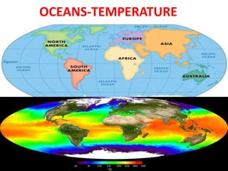
  • 5. Temperature of Ocean water • Ocean water temperature increases when it receives insolation from sun. Temperature of ocean water is not same rather it varies from place to place and time to time. • Various factors affecting ocean water temperature are: • 1. Latitude: temperature of ocean water is more near to equator and less at poles. It is because of more heat received by the sun near equator as compared to poles.
  • 6. • 2.Winds: In difference in temperature and pressure conditions result in movement of wind from one area to another. Warm winds increases the temperature of the region it passes and and cold wind decreases the temperature of the region it passes. • 3.Ocean currrent: Movement of water by wind in a particular direction is called ocean current. Warm ocean current increases the temperature of the region it passes like Gulf Stream and Cold current like Labrador current near Greenland decreases the temperature of the region it passes.
  • 7. • 4. Unequal distribution of Land and Sea: • Distribution of land is more in northern hemisphere as compared to southern hemisphere. Therefore oceans in the northern hemisphere like Pacific Ocean are warmer as compared to oceans in southern hemisphere like Antarctica.
  • 8. • 5.Icebergs: Icebergs decrease the temperature of the ocean water of which they are present. • 6.Salinity: Oceans with high salinity like tropical areas have more temperature as compared to oceans near poles like Arctic Ocean.
  • 9. Vertical Distribution of Temperature I Oceans • Temperature of oceans is maximum at surface because of heat received by the sun. As we go down the ocean surface, temperature starts decreasing. • The region from where there is certain decrease in temperature is called Thermocline. • 90% of total volume of water is present below thermocline.
  • 10. • The first layer of Thermocline ranges between 0-500 metres with temperature ranging between 20-25°C. it is present near tropical areas. • The second layer of Thermocline ranges between 500-1000 metres with temperature ranging between 8-16°C. it is present near temperate areas. • The third layer of Thermocline is very cold and extends upto the depth of ocean floor.the temperature ranges between 0- 4°C. it is present near polar areas.
  • 11. Horizontal Distribution of Temperature in Oceans. • Horizontal Distribution of temperature in oceans is studied with the help of distribution of land and sea. • In northern hemisphere distribution of land is more as compared to southern hemisphere. • Oceans in northern hemisphere have a higher temperature like Pacific Ocean as compared to Southern hemipshere like Antartica. • Temperature in oceans of tropical zone is 27°C, 14°c in temperate lattitudes and 0°c near poles. • The rate of decrease of temperature is 0.5°c per lattitude in oceans. • The average temperature for all oceans is 17.2°C.
  • 12.
  • 14. Introduction • Salinity refers to presence of dissolved salts in sea water. • It is calculated as ppt or parts per thousand grams of sea water. • The average salinity of sea water is 35 per thousand grams of sea water. • Salts Ppt Chlorine (Cl2) 19 Sodium(Na) 10 Sulphate(SO4) 3
  • 15. Factors Affecting Salinity • 1.Temperature: Areas which are near to equator have high temperature which result in high evaporation and adding salts on ocean surface. • 2. Fresh Water: Areas which receive fresh water from rivers have low salinity. Fresh water mixes with the water with salts and thus reduces its salinity. • 3. Ocean Currents: Warm Ocean currents carry high saline water to the area they move and cold currents carry less saline water to area they move.
  • 16. HORIZONTAL DISTRIBUTION OF SALINITY • 1. Salinity in Open Seas: • Open seas are the seas which have access to fresh water. If open seas are located near to Equator they will have less salinity because heavy rainfall will increase the fresh water and decrease the salinity. • Salinity is also less in polar areas because melting of ice adds fresh water and help in decreasing the salinity.
  • 17. • 2 Salinity in partially enclosed seas: • Partially enclosed seas are the seas which are partially covered by land and other by sea like Mediterranean Sea, Red sea and Baltic Sea. • Mediterranean Sea have high salinity because of its location in high temperature area which increases the evaporation rate and absence of large rivers helps in increasing the salinity in the area.
  • 18. • Salinity of Enclosed Seas: • Enclosed seas are the seas which are covered from all sides. • Lake Van in Turkey have 330 ppt as the salinity, Dead Sea have 24 pt salinity and Great Salt Lake have 220 ppt salinity.
  • 19. Vertical Distribution of Salinity • On the sea surface salinity is increased by high evaporation and is reduced by the addition of fresh water. • More salinity will add more salts to water, make water more dense. With the increasing depth the salts keep on depositing and salinity increases with increasing depth. • Halocline is the line which help in reflecting the amount of salinity in the area.
  • 20. Relief of Ocean Floor or Features of Ocean Floor
  • 21. Introduction • The ocean floor is not plain as believed. • Floor of various oceans have complex mountain ranges, trenches etc. • Tectonic plates movement, volcanic erruptions inside oceans, depositional or erosion of material by sea waves has resulted in its formation. • The various features of ocean floor are: • 1. Continental Shelf • 2.Continetal Slope • 3.Oceanic Deeps or Trenches • 4.Abyssal Plains • 5. Submarine Ridges • 6.Abyssal Hills
  • 22.
  • 23. • 1.Continental Shelf: • It is the gentle seaward sloping surface extending from coast towards open sea. • It is formed by sediments brought down by rivers, wind, waves etc. • It covers 7.5% of total area of worlds ocean. • It have a gentle slope 1°C and depth is normally 200 mts.
  • 24. • Importance of Continental Shelf: • Sun’s rays can’t penetrate upto Continental Shelf which encourages growth and reproduction of marine organisms. • Marine food comes from this part of ocean floor. • Provides richest fishing grounds. • Storehouse of various minerals like petroleum and natural gas. • It is also storehouse of sand , gravel etc.
  • 25. • 2.Continental Slope: • It is the steep slope separating a continental shelf and a deep ocean basin. • The gradient of slope varies between 2-5° • The depth of the slope is between 200-3600 mts.
  • 26. • 3.Oceanic Deeps or Trenches • These are deepest part of the oceans. • They occur at the base of continental slope. • They are long, narrow and deep in nature. • They extend upto 5500 mts • They are formed by the folding and faulting of the Earth’s Crust. • Mariana trench is the deepest trench of the Pacific Ocean.
  • 27. • 4. Abyssal Plains • These are also called as Deep Sea Plains. • They are flat and smooth in nature. • These plains are covered with fine sediments like clay, silt etc. • They are cover 40% of the ocean floor. • they depth vary between 3000-6000 mts • They are present in all major oceans and seas in world.
  • 28. • 5.Submarine Ridges:. • It consist of various underwater mountain ranges in sea. • It is spread over thousand kilometers longs • It is formed by converging or diverging of the plates. • They form the longest mountain system under the Earth. • Mid Atlantic ridge in Atlantic Ocean is the example of Submarine Ridge.
  • 29.
  • 30. • 6.Abbysal Hills: • There are thousand hills inside the ocean floor. Various hills are Sea Mount and Guyots. • A)Sea Mount: • It is the mountain peak which is rising from the ocean floor but they are not reaching the ocean surface. • They are of volcanic origin. • They can be 3000mts to 4500 mts. • Example Hawaiian Islands in Pacific Ocean in Japan
  • 31. • B)Guyots: • The flat bottomed sea mount is called Guyot. • It is volcanic origin. • Erosion of sea mount by various agents like water, waves give this feature. • Example: Hawaiian Sea Guyot in Japan.
  • 32.
  • 34. Introduction • Ocean water is never static but keeps on moving horizontally or vertically. The horizontal motion refers to ocean waves and currents and vertical motion is called tides.
  • 35. OCEAN WAVES • The movement of water due to energy produced by wind is called Wave. • A thing is floating up and down but it is carried by the wind in a particular direction. • As wave approaches the beach, it slows down. This is due to friction between water and surface.
  • 36. • The size of waves depend upon following factors: • 1. Velocity of Wind: More the velocity of wind, more will high will be the wave. • 2.Duration of Wind: if wind moves a longer duration of time, more waves will be formed. • 3.Distance (Area) over which wave is moving: • If wave is moving over an area with more speed, long time, and over an area which does not stops it then more high wave will be formed.
  • 37. Terms associated with Waves: • Crest: The upper part of the wave is called Crest. • Trough: the lower part of the wave is called trough. • Wavelength: The distance between Crest and Trough is called Wavelength. • Waveheight: vertical distance between Crest and Trough is called Wave height • Wave amplitude: Half of the wave height is called Wave amplitude. • Wave frequency: the number of waves passing a given point during one second time interval is called wave frequency.
  • 39. OCEAN-TIDES • The periodic rise and fall of sea level due to gravitational attraction of sun and moon acting on Earth is called tides. • It occurs twice a day after 12 hours 26 minutes. • The rise of sea level is called high tide or flood tide and fall is called low tide or ebb tide.
  • 40. ORIGIN OF TIDES • 1.Gravitational pull of Sun and Moon • Water of Earth is held in position by its own gravity but gravitational pull of moon and sun acts on it. • Due to large size of the sun, sun is attracting more but at large distance it is not able to have more gravitational force. • Moon’s size is low but its near to Earth so gravitational pull is more
  • 41. • 2. Centrifugal Force: It is force applied moving in circular orbit. It moves from centre to outside. • 3. Tide Generating Force: • Difference between centrifugal and gravitational pull of moon.
  • 42. Types of Tides • 1.On basis of frequency: • 1.Semi-diurnal Tide: When there are two high and two low tides in a day. But tides are of same height. • 2.Diurnal Tide: There is one high tide and low tide but the tides are of same height. • 3. Mixed Tide: Tide having variations in high and low tide is called Mixed tide.
  • 43. • 2. On basis of Position of Earth, Moon and Sun. • 1. Spring Tide: • When Sun, Moon and Earth are in straight line, they exert combined gravitational pull on Earth. Therefore on both days tides are high.
  • 44. • 2. Neap Tide: • When Sun, Moon, Earth are at right angle it is called Neap tide. • Attraction of Sun and Moon tide to balance each other as a result of which low tide is formed.
  • 45. • When moon orbit is near to Earth it is called Perigee and when moon is farthest from Earth it is called Apogee.
  • 46. Importance of Tides • 1.Tidal force can be used for generating electricity. Example in India, Gujarat Gulf of Kuchch and Khambat have high potential. • 2. Tides keep sea water in motion and avoids its freezing. • 3.tides leave shells and other sea products on shore. • 4. Fishermen go to open sea for catching fish on high tide and come back on low tide. • 5. Tides help in making river water navigable.
  • 48. Meaning of Ocean Currents • Regular movement of water in a particular direction is called ocean currents.
  • 49. Factors responsible for origin of currents: • 1. Temperature difference: At the Equator, temperature is high and the water also becomes light on heating. At the poles, the temperature is low and water becomes dense. Difference in temperature is also one the cause of movement of water from polar areas to equator. • 2. Prevailing Winds: Winds move in area due to indifference in temperature conditions. When winds blow in a particular direction and take the water along is called ocean currents.
  • 50. • 3.Evaporation: More evaporation reduces the level of water and water moves from surrounding area to balance the level of water. • 4. Rotation of Earth: Due to rotation of Earth, coriolis force becomes active because of which winds move right in northern hemisphere and left in southern hemisphere. Winds carry the water also in its direction and give birth to currents. • 5.Salinity differences: Water having high salinity is denser and thus moves down. Light water with less salinity moves toward it and a current is formed. Example : Mediterrenean Sea have highest salinity which thus causes to water move from Atlantic Ocean.
  • 51.
  • 52. TYPES OF OCEAN CURRENTS • 1.ON THE BASIS OF DEPTH • 1.SURFACE CURRENTS: The currents which are prevalent over the surface of water. They constitute over 10% of all water in the ocean. • 2.DEEP WATER CURRENTS: • When the water is carried by wind due to various differences like salinity, density deep in the oceans is called DEEP WATER CURRENTS. They constitute 90% of total ocean water.
  • 53. • 2. ON THE BASIS OF TEMPERATURE • 1.WARM CURRENTS: • The currents which move from warm areas of tropics to cold areas of polar latitudes is called warm currents. They increase the temperature of the area to which they go. Example: Gulf Stream is a warm current in Atlantic Ocean. • 2. COLD CURRENTS: • The currents which move from cold areas to warm areas is called Cold Currents. There temperature is lower so they decrease the temperature of the area they go. Example: Canaries current is a cold current.