AUV-based ocean observations support marine mammal ecology studies
•
2 likes•227 views

AUV-based physical, biological, and acoustic observations in support of marine mammal ecology studies
Recommended

Recommended
More Related Content
Similar to AUV-based ocean observations support marine mammal ecology studies
Similar to AUV-based ocean observations support marine mammal ecology studies (20)
More from David Fratantoni
More from David Fratantoni (10)
Recently uploaded
Recently uploaded (20)
AUV-based ocean observations support marine mammal ecology studies
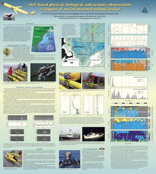
- 1. ���������������� ������ ����������������������������� ������ ������������ ��������� ������������� ������������� ��������������� ����������� ������������� ������ ������������������ ����������� ��� ��� ��� ��� ��� ��� ��� ��� Georges BankNantucket Sound Great South Channel Gulf of Maine 50 100 200 NightDay NightDay NightDay NightDay NightDay � � �� �� �� � � � � � � WindSpeed(m/s) WaveHeight(m) Wind Wave � �� �� �� �� ��� ��� ��� ��� ��� ��� ��� ��� ���� ���� ���� ���� ���� ���� ���� ���� ���� ���� � �� �� �� �� ��� ��� ��� ��� ��� ��� ��� ��� ���� ���� ���� ���� Salinity � �� �� �� �� ��� ��� ��� ��� ��� ��� ��� ��� ��� � �� �� �� �� ��� Temperature(C) Day of May 2005 Depth(m)Depth(m) ��� ��� ��� � �� �� �� 0-100mVelocity(cm/s) North East � �� �� �� �� ��� �� �� �� ��� ��� ��� ��� ��� ��� � �� �� �� �� ��� ChlFluorescence(counts) Depth(m) � �� �� �� �� ��� ���� ���� ���� ���� ���� ���� ���� ���� ���� ���� ���� ���� ���� � �� �� �� �� ��� 1MHzAcousticBackscatter(dB) Depth(m) � �� �� �� �� ��� ��� ��� ��� ��� ��� ��� ��� ���� ���� ���� ���� ��� ��� ��� ��� ��� ��� � �� �� �� �� ��� ��� ��� ��� ��� ��� ��� ��� ���� ���� ���� ���� 700nmBackscatter(counts) Depth(m) Day of May 2005 � �� ��� ��� ��� ��� ��� ��� ��� ��� ��� ���� ���� ���� ���� CallRate(perhour) WE06 WE07 WE08 16-160 Hz Downsweep Calls Day of May 2005 � �� �� �� �� �� CallRate(perhour) WE06 WE07 WE08 80-220 Hz Upsweep Calls Observed at NDBC Buoy 44018 30 nm east of Nantucket Slab Velocity measured by glider Temperature Salinity ADCP 1 MHz Backscatter Fluorescence Optical Backscatter (red) (lleft) Gliders are prepared for deployment aboard R/V Tioga. Dave Fratantoni bangs a wrench against a pipe to make a clearly identifiable sound that will be used to identify acoustic recorder clock drift. (right) A right whale mother and calf. (left) Engineer Paul Fucile checks the operation of a glider prior to deployment. (right) Research Associate John Lund per- forms final checks before deploying an ADCP-equipped glider. � �� �� �� ��� � � � ��������������� ���� ���� ���� �������� � �� �� �� ��� ��� ��� ��� ��� ��� ��� ��� ������������������������ �� ��� ��� ��� ��������������������� WE07 Profile #190 9 May 2005 1628Z 41.53N 69.07W � �� �� �� ��� � � � ��������������� ���� ���� ���� �������� � �� �� �� ��� ��� ��� ��� ��� ��� ��� ��� ������������������������ �� ��� ��� ��� ��������������������� WE07 Profile #24 6 May 2005 2334Z 41.51N 69.03W Representative vertical profiles from glider WE07 showing temperature, salinity, chlorophyll fluorescence, and optical backscatter at 700 nm. (left) Profile from 6 May prior to the onset of the gale. Note the vertically-thin peak in fluorescence located in the strong gradient region at the base of the surface mixed layer. The elevated optical backscatter below 70 m ac- companied by low fluorescence is suggestive of suspended bottom sediments. Acoustic backscatter profiles (see panels at far right) exhibit a similar structure. (right) A profile in approximately the same position on 9 May as the wind and waves began to subside. Note the deep mixed layer in temperature and salinity and the subsurface slab of elevated fluorescence. CourtesyofNewEnglandAquarium AUV-based physical, biological, and acoustic observations in support of marine mammal ecology studies David M.Fratantoni,Physical Oceanography Dept.and Mark F.Baumgartner,Biology Dept. Woods Hole Oceanographic Institution,Woods Hole,MA 02543 dfratantoni@whoi.edu • mbaumgartner@whoi.edu ������� ������� ������ ����� ����� ������ ������ ���� ���� ���� ���� 150 150 Platforms, Sensors and Methods On May 6,2005 four gliders were deployed from theWHOI R/V Tioga in the Great South Channel near a group of feeding right whales identified by observers aboard the NOAA R/V Albatross IV. Each vehicle was equipped with a Sea-Bird CTD,aWet Labs bb2f chlorophyll fluorometer/two-channel optical backscatter sensor,and aWHOI fiber optic PAR sensor. All four vehicles profiled to 100 m depth approximately once every 20 minutes.The vehicles transmitted position and status information once every two hours via Iridium satellite phone. Strong tidal velocities (60+ cm/s;well in excess of the glider’s maximum forward speed) resulted in oscillatory north-south trajectories. The inability of the slow-moving gliders to maintain geographic position was not viewed as a disadvantage for this application. To the extent that the zooplankton sought by the whales,and the whales themselves,are advected by the tides,it is likely that the glider’s weakly-controlled motion resulted in measurements taken in closer proximity to the animals than possible using a geographically-fixed platform. One of the vehicles was equipped with an experimental 1 MHz NortekAquadopp acoustic Doppler current profiler (ADCP) mounted externally on top of the hull. A custom head design enabled a vertical orientation of theADCP beam pattern during glider dives. TheADCP measured profiles of velocity and (uncalibrated) acoustic backscatter once per second. Only downcast data meeting stringent pitch,roll, heading rate,and vertical descent rate criteria were retained for analysis. To estimate the proximity of each vehicle to whales (and hence to relate the observed oceanographic parameters to whale distribution and feeding behavior),we developed a new low-frequency passive acoustic recorder to detect whale vocalizations. The recorder consists of an externally-mounted,faired hydrophone,a pre-amplifier and analog filter,analog-to-digital converter,and a digital recorder based on the Persistor CF-2. Data is collected at 2 kHz and stored on a 2GB compact flash card. Upon recovery,a simple automated detection/classifica- tion scheme was use to process the recorded data. Whale vocalizations between 10 and 1000 Hz were first identified as any sound above a variable threshold within a specified frequency band. Calls were then isolated using frequency-specific thresholds. These variable thresholds accounted for changes in background noise due to,for example,a passing ship. Finally,each call was classified based on its statistical charac- teristics (e.g.,duration,frequency span,slope,and variance). (top) Bathymetry of the Great South Channel east of Cape Cod, Mas- sachusetts. Areas shallower than 50 m are shaded in white. The location of glider profiles obtained during the pi- lot study are shown with colored dots. (right) Expanded view of the glider oper- ating area. Four gliders collected more than 2400 vertical profiles over 5 days while being advected meridionally by the semidiurnal tide. Examples of output from the detection/classification routine for (left) a 16-160 Hz downsweep call and (right) a 80-220 Hz upsweep call re- corded by glider WE07. The recorded acoustic data is processed to yield a spectrogram (upper panel) which is then sampled to identify local max- ima in sound amplitude in specific frequency bands. Calls are isolated in the neighborhood of local maxima and then classified according to their statistical characteristics. Results •We have obtained a unique suite of high-resolution physical and biological observa- tions using an array of autonomous vehicles equipped with two new acoustic sensor packages. • Observations of the physical structure of the water column (via CTD),the relative abundance of phytoplankton and zooplankton (via fluorescence and acoustic backscat- ter,respectively),and the call rate of vocalizing whales were obtained around the clock and through extreme weather conditions outside the operating envelope of a research vessel. •An observed diel cycle in 16-160 Hz downsweep vocalizations was negatively corre- lated with near-surface acoustic backscatter maxima and may be related to the diel ver- tical migration of zooplankton. • Based on the clarity and persistence of vocalizations recorded by the glider array,we anticipate that localization of individual animals will be possible. •The use of high-enduranceAUV’s in marine mammal ecology studies allows access to time and space scales unattainable by traditional means and could significantly advance both research and conservation efforts. (top) Time series of several parameters measured during the pilot study by glider WE04. Wind speed and wave height were obtained from NDBC buoy 44018 located 30 nm east of Nantucket, or about 15 nm from the study area. Maximum wind gusts exceeded 21 m/s and significant wave height approached 5 m. The glider intrinsically measures a slab velocity averaged over its profiling depth and dive cycle time. Temperature and salinity are measured by the glider’s Sea-Bird CTD. (middle) Call rate for two specific vocalization types determined using our detection/classification scheme. Note the extreme similarity in call rate observed by each of the recorder-equipped gliders. This suggests that the gliders remained in proximity to whales during the course of the study. There were many 80-220 Hz upsweep calls during the first day of the record when numerous right whales were visu- ally confirmed to be in the glider operating area. This call type was essentially absent following onset of the gale. In contrast, the 16-160 Hz downsweep calls were evident throughout the record and showed a strong diel variation that is negatively correlated with 1 MHz acoustic backscatter (below). Call rate was highest during daytime and exhibited a minimum each night. (bottom) Time series of uncalibrated 1 MHZ ADCP acoustic backscatter, chlorophyll fluorescence, and 700 nm (red) optical backscatter. Note the apparent diel migration of zooplankton in the acoustic backscatter panel. Also note the strong negative correlation between acoustic backscatter and 16-160 Hz call frequency. Both acoustic and optical backscatter measurements suggest an enhanced level of suspended particles at depths below 100 m. During the first 36 hours numerous profiles exhibited rela- tively thin layers of elevated chlorophyll fluorescence located at the base of the mixed layer. Two potential density contours (25.3 and 25.5) are shown in each panel. Acknowledgements DMF acknowledges the support of the Physical Oceanogra- phy,Ocean Engineering,and Biology and Optics programs of the U.S.Office of Naval Research. This research is fund- ed in part by the ONR Layered Organization in the Coastal Ocean DRI directed by Dr.James Eckman. MFB acknowledges support from the Penzance Founda- tion,the Northeast Consortium,and the NOAA RightWhale Grants Program. We thank FredWenzel and John Nicolas of the Northeast Fisheries Science Center for support in the field. Glider field operations were managed by John Lund. Paul Fucile,Robin Singer,Jim Partan,and Lee Freitag con- tributed to the development and implementation of the acoustic recorders. We acknowledge the able assistance of the captain and crew of the research vessels Tioga and Albatross IV. (left) The WHOI R/V Tioga cruises at 20 kts enabling glider deployment and recovery operations to be performed as 12- hour day trips from Woods Hole. (right) The NOAA R/V Albatross IV. Observers aboard visually identified aggregations of right whales and guided deployment of the glider array. A North Atlantic right whale with mouth open. Engineer Paul Fucile shares a special moment with glider WE08’s acoustic recorder. �� �� �� �� �� �������������� � �� ��� ��� ��� ��� ��� �������������� �� �� �� �� �� �������������� �� �� �� �� �� �������������� �� �� �� �� �� �������������� �� �� �� �� ��� ��� ��� ��� �������������� �� �� �� �� �� �������������� �� �� �� �� ��� ��� ��� ��� �������������� Calanus finmarchicus Overview A central goal of marine mammal ecology research is to understand the environmental factors that influence animal distribution. Here we present results from a recent pilot study during which four high-endurance autono- mous gliders were used to characterize the physical and biological environ- ment near actively feeding NorthAtlantic right whales (Eubalaena glacialis). This application exploits several intrinsic characteristics of glid- ers:high endurance,fine vertical measurement resolution,and relatively silent operation. The slow-moving (0.5 m/s) gliders collected five days of high-resolution physical,bio-optical,and both active and passive acoustic measurements in proximity to whales feeding in the Great South Channel east of Cape Cod,Massachusetts. Passive acoustic recorders deployed on the array of gliders enabled detection and classification of whale vocaliza- tions and will eventually allow localization of individual animals. Oceanographic Context NorthAtlantic right whales migrate seasonally to the Great South Channel to feed on zooplank- ton,and in particular,the copepod Calanus fin- marchicus. The channel,bounded by Nantucket Shoals and Georges Bank,provides a relatively shallow (75 m) connection between the southern Gulf of Maine and the New England slope. Maximum depth in the channel is near 200 m. The region is characterized by strong semidiurnal tides with velocities exceeding 50 cm/s. During this study,water column stratification was significantly influenced by a strong,late-season northeasterly gale. Maximum wind gusts exceeded 21 m/s and significant wave height approached 5 m. A relatively warm,fresh,and stratified near-sur- face layer evident near the beginning of the study was mixed away during the gale and replaced by a deep (70 m) mixed layer. A sharp pyc- nocline separated the surface water from the cooler,more saline interior. ChrisTremblay E.PaulOberlander/MichaelMoore �� �� �� �� �� �������������� � ��� ��� ��� ��� �������������� �� �� �� �� �� �������������� � � �� �� �� �� �� �������������� �� �� �� �� �� �� �� �������������� �� ��� ��� ��� ��� ��� ��� �������������� �� �� �� �� �� �� �� �������������� �� ��� ��� ��� ��� ��� ��� �������������� Annual migration of North Atlantic right whales