Continental Mapping Projects - Wood Road Re-alignment
•
0 likes•3,154 views

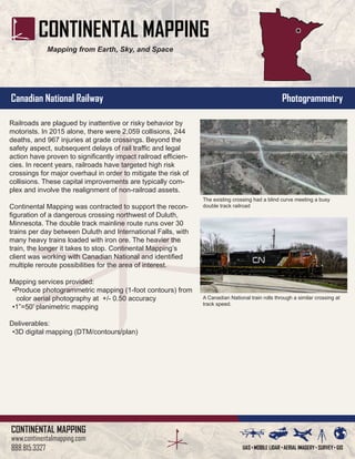
Continental Mapping was contracted to provide mapping services to support the reconfiguration of a dangerous railroad crossing in Minnesota. The crossing had issues with collisions between trains and motor vehicles, resulting in deaths, injuries, and delays. Continental Mapping used aerial photography to produce high-accuracy contour maps and planimetric maps of the area to identify options for rerouting the crossing to reduce safety risks from the blind curve and busy double track railroad. The maps were delivered in a 3D digital format to support redesigning the crossing configuration.
Recommended

Recommended
More Related Content
What's hot
What's hot (20)
Similar to Continental Mapping Projects - Wood Road Re-alignment
Similar to Continental Mapping Projects - Wood Road Re-alignment (20)
More from Continental Mapping Consultants
More from Continental Mapping Consultants (20)
Recently uploaded
Recently uploaded (20)
Continental Mapping Projects - Wood Road Re-alignment
- 1. CONTINENTAL MAPPING www.continentalmapping.com 888.815.3327 Canadian National Railway Photogrammetry Mapping from Earth, Sky, and Space Railroads are plagued by inattentive or risky behavior by motorists. In 2015 alone, there were 2,059 collisions, 244 deaths, and 967 injuries at grade crossings. Beyond the safety aspect, subsequent delays of rail traffic and legal action have proven to significantly impact railroad efficien- cies. In recent years, railroads have targeted high risk crossings for major overhaul in order to mitigate the risk of collisions. These capital improvements are typically com- plex and involve the realignment of non-railroad assets. Continental Mapping was contracted to support the recon- figuration of a dangerous crossing northwest of Duluth, Minnesota. The mainline route runs over 30 trains per day between Duluth and International Falls, with many heavy trains loaded with iron ore. The heavier the train, the longer it takes to stop. Continental Mapping’s client was working with Canadian National and identified multiple reroute possibilities for the area of interest. Mapping services provided: •Produce photogrammetric mapping (1-foot contours) from color aerial photography at +/- 0.50 accuracy •1”=50’ planimetric mapping Deliverables: •3D digital mapping (DTM/contours/plan) The existing crossing had a blind curve meeting a busy double tracked railroad A Canadian National train rolls through a similar crossing at track speed. A Canadian National train is visible in this raw ortho scan as it approaches the Wood Road crossing