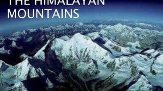
2. THE HIMALAYAN
MOUNTAINSThe Himalaya , is a mountain range in Asia separating the plains of
the Indian subcontinent from the Tibetan Plateau. The range has
many of Earth's highest peaks, including the highest, Mount
Everest, at the border between Nepal and China. The Himalayas
include over fifty mountains exceeding 7,200 m (23,600 ft) in
elevation, including ten of the fourteen 8,000-metre peaks. By
contrast, the highest peak outside Asia (Aconcagua, in the Andes)
is 6,961 m (22,838 ft) tall.The Himalayas are inhabited by 52.7
million people,and are spread across five countries: Bhutan,
China, India, Nepal and Pakistan. The Hindu Kush range in
Afghanistan[6] and Hkakabo Razi in Myanmar are normally not
4. THE HIMALAYAN MOUNTAINS WERE DIVIED
INTO 3 REGIONS KNOWN AS THE;
•The Himadri
•The Himachal
•The Shivwaliks
5. •'Himadri’ also known as great or inner himalayas is
the most continuous range consisting of the loftiest
peaks with an average height of 6,000 metres.
•it contains all the prominent himalayan peaks
•The folds of 'himadri‘ are asymmetrical in nature
•The cores of this parts of himalaya is composed of
granite
•It is perennially snow bound,and a number of glaciers
THE HIMADRI
6. THE HIMACHAL
• The himachal is also known as lesser himalaya
• The ranges are mainly composed of highly compressed and
altered rocks
• The altitude varies between 3,700 and 4,500 metres and
width of 50 km
• The pir panjal range is the longest and the dhaula dhar and
mahabharat range is prominent once
• This region is well known for its hill stations
The himachal
7. THE SHIVWALIKS
• The outer most range of the himalaya is called the
Shivwaliks
• They extend over a width of 10-50 km and have an altitude
varying from 900 to 1100 metres
• These ranges are composed of unconsolidated sediments
• These valleys are covered with thick gravel and alluvium
• The longitudinal valley lying between lesser himalaya and
Shivwaliks are known as duns
• Dehra dun,kotli dun and patli dun are some well known
The
shivwaliks
9. These divisions have been demarcated by river
valleys. For instance, the part of Himalayas lying
between Indus and Satluj has been traditionally
known as Punjab Himalayas but it is also known
regionally as Kashmir and Himachal Himalayas
from west to east respectively.
Punjab
himalayas
Kuman
himalayasThe part of the Himalayas lying
between Satluj and Kali rivers is known
as Kumaon Himalayas
10. Nepal
himalayasThe Kali and Tista riven demarcate
the Nepal Himalayas.
Assam
himalayasThe part lying between Tista
and Dihang rivers is known as
Assam Himalayas
13. Mount everest is Earth’s highest mountain above sea level, located
in the Mahalangur Himal sub-range of the Himalayas. The China–
Nepal border runs across its summit point.The current official
elevation of 8,848 m (29,029 ft), recognised by China and Nepal,
was established by a 1955 Indian survey and confirmed by a 1975
Chinese survey.In 1865, Everest was given its official English name
by the Royal Geographical Society, as recommended by Andrew
Waugh, the British Surveyor General of India, who chose the name
of his predecessor in the post, Sir George Everest, despite
Everest’s objections.
14. HIMALAYAS IN INDIA
• Himalayas has saved us from many
disasters
• They help us by providing heavy rain fall
as they stop the clouds from moving away
• tarras farming is practised in this area
• people come here for adventure rides
• Over 300 people had died in himalayas
and was not found till now.
HIMALAYA
S
17. Many rivers originate from himalayas like the indus,
brahmaputra,sutlej,ganga,chanab,yamuna,beas,kali
gandaki,koshi,teesta etc. are some of the rivers .out
of this only a number of 3 are in india.totally there
are 20 major rivers in himalayas.
Jhelum,chenab,beas,ravi and sutlej are also known as
the five sisters . The picture in the previous slide
show the rivers of the Himalayan mountains
19. THE FORMATION OF
HIMALAYAS
The Himalayan mountain range and Tibetan plateau have
formed as a result of the collision between the Indian Plate and
Eurasian Plate which began 50 million years ago and continues
today.the Himalayas are still rising by more than 1 cm per year
as India continues to move northwards into Asia, which explains
the occurrence of shallow focus earthquakes in the region
today. However the forces of weathering and erosion are
lowering the Himalayas at about the same rate. The Himalayas
and Tibetan plateau trend east-west and extend for 2,900 km,
reaching the maximum elevation of 8,848 metres (Mount
Everest – the highest point on Earth).
FORMATION OF
HIMALAYA
20. THE NAME
HIMALAYA
LOCATION OF
HIMALAYA
The name of the mountain range, Himalaya,
originally came from the world Himā-laya, which
means ‘ Abode of Snow’ in Sanskrit. In Tibetan,
the Himalaya means the Land of Snow. And in
Chinese, it is called Ximalaya.
The Himalaya is located along the border of
India, Nepal, Pakistan, Bhutan and China in
southern Asia. As a part of the frontier, the
Himalaya is southwest to China, north to Bhutan,
THE NAME HIMALAYA
![THE HIMALAYAN
MOUNTAINSThe Himalaya , is a mountain range in Asia separating the plains of
the Indian subcontinent from the Tibetan Plateau. The range has
many of Earth's highest peaks, including the highest, Mount
Everest, at the border between Nepal and China. The Himalayas
include over fifty mountains exceeding 7,200 m (23,600 ft) in
elevation, including ten of the fourteen 8,000-metre peaks. By
contrast, the highest peak outside Asia (Aconcagua, in the Andes)
is 6,961 m (22,838 ft) tall.The Himalayas are inhabited by 52.7
million people,and are spread across five countries: Bhutan,
China, India, Nepal and Pakistan. The Hindu Kush range in
Afghanistan[6] and Hkakabo Razi in Myanmar are normally not](data:image/gif;base64,R0lGODlhAQABAIAAAAAAAP///yH5BAEAAAAALAAAAAABAAEAAAIBRAA7)