
Recommended
Recommended
More Related Content
What's hot
What's hot (20)
Similar to Smart City Proposal for Sustainable Stormwater Management
Similar to Smart City Proposal for Sustainable Stormwater Management (20)
Recently uploaded
Recently uploaded (20)
Smart City Proposal for Sustainable Stormwater Management
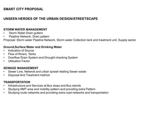
- 1. SMART CITY PROPOSAL UNSEEN HEROES OF THE URBAN DESIGN/STREETSCAPE STORM WATER MANAGEMENT • Storm Water Drain gutters • Pipeline Network, Drain pattern Proposal: Storm water Pipeline Network, Storm water Collection tank and treatment unit, Supply sector Ground,Surface Water and Drinking Water • Indication of Source • Flow of Rivers, Tanks • Overflow Drain System and Drought checking System • Utilization Factor SEWAGE MANAGEMENT • Sewer Line, Netwrok and urban sprawl relating Sewer waste • Disposal And Treatment method TRANSPORTATION • Infrastructure and Services at Bus stops and Bus stands • Studying NMT area and mobility pattern and providing extra Pattern • Studying route networks and providing extra road networks and transportation
- 2. Urban Sprawl Identified: • Ground Wate Depletion Reduction of open area and Recharge areas Extraction amount more than recharge amount Poor monitoring and Policy Frame work of ground water act No such Seperate Hydrology Teams and Office to enforce and enact laws • Seawater Intrusion Due to fall in level of Ground water increase in Salinity and Soil erosion Depletes the Mineral layer of soil Negative Impact on vegetation • Industiral Wastes and Sewage wastes are being released to open Fresh water Delpeting the Aesthetical Hygenic Character of the Urban also reducing the liveability • The Irrigation Canal is being connected as main sewer polluting the fresh water and sea water • Poor treatment of the Sewage Sludge and no such propoer treatment units • Better Infrastructure of Bus stand and Bus stops • Provided Better services at Bus Stops and smart devices for asssiting Passengers and tourists • Providing extra Transport line to Highly mobilized area • Special Circulator for assisting tourists
- 3. • Pondicherry Rainfall Amnt - 1250mm for 50 days annualy From both NE and SW monsoon • River Source - Sankarabarani River - 34Km RL Pambaiyar River - 69Km RL Guduvaiyar River - 19,3Km RL Malatar River - 10 Km RL Pennaiyar River - 13km RL • Water Source - 84 minor tanks and 2 major tanks: Ousteri and Behour • Boulevard Town and its Coastal area Falls under the category of CRZII i.e development of new Proposal within a already developed built space and the FSI/FAR and other regulation falls under regular Town Planning Considerations and BYE-LAWS • GROUND WATER REGULATION ACT Establishment of Ground water Authority Perminting new concerns for obtain and usage of Ground water Licensing and monitoring the existing Ground water wells
- 5. Solutions and Proposals ICT HYDROLOGICAL DATA CENTRE A area in proximity of beach to be identified of 1 acre and planning model other technology incorporating design solutions should be given for Proposal of Hydrological Data Research Centre that would monitor and enforce laws for Ground Water, Surface water, Drinking water Supply, Meteorological Water Supply and research for the above mentioned aspects
- 6. • Construction of Check dams at sea for breaking the flow of water runoff and to store fresh water in Canals • Storing waters in reservoirs and tanks for needs • Providing entire Sewer line for the city and storm water line • Underground Sewage treatment plant • Strom water treatment and redirecting for irrigation • Desalination Plant for supply of drinking water REQUIREMENTS: Meteorological Research Lab Ground water And Storm water management office and Lab Sewarge Treatment reguation Office Enforcement Office Administrartive Office Accounts and Management Office Building Security and Management Service Office
- 7. SEWAGE TREATMENT PLANT Underground sewage treatment Plant Benefits • Small footprints reduce land use. • Expandable and flexible designs • Completely above ground installation. • Easy to Transport, relocate, install & Expand. • High removal efficiency for nitrogen, BOD & COD, • Treated Water reuse in irrigation and grey water applications. • Minimum maintenance requirements. • Full technical, installation and operation support from trained and experienced Shubham Team. • Proven Technology with reliable performance. • Reuse of Wastewater in gardening application.
- 8. DESALINATION PLANT Seawater desalination is the removal of salt and impurities from seawater to produce fresh water. Our desalination plants do this via a reverse osmosis process. The filtered seawater is then forced under pressure through special membranes whereby the osmosis process that normally occurs in nature is reversed. • Thermal Osmosis • Electrical Osmosis • Pressured Osmosis
- 9. ARTIFICIAL GROUND WATER RECHARGE Check Dams Percolation ponds Recharge shaft Sub surface Dykes Areas to be noted for proposing particular methodology and the need and source of artificial ground water recharge at the particular site. SMART METERING: To maintain ground water level and pond recharge smart metering on every house hold is required. refer cape town Percolation Ponds Recharge Shaft
- 10. Check Dams Sub Surface Dykes
- 11. Transportation: • Surfaced Road - 557 km Unsurfaced Road - 48 Km • NMT Zone: Re-directing routes, extraelevated driveways and footpaths for achieving NMT along the Heritage Town • Urban Sprawl Identified: Encroached footpaths leading to reduced walkway and pedestrian safety Discontinuous Footpaths Poor Standards for Differently abled no sperate lanes for NMT Heavy traffic at junctions due to reduced road width and road density • Public Transportation : No of Buses - 137 Intra-Urban Buses 45 Urban Buses Standards Prescribed by world bank is 1.2buses/1000 Peoples • Prominent Routes Connecting Residential with commercial and Industrial • Pondycherry to Gnanapatichetikulam, Gorimedu, Bahour, Metupalayam, CHinnaveeramapatinam • Highyly Densed transportation Route : Pondycherry to Villianur, Thavalakuppam, Bahour,kalapet,Lawspet,Airport • Identified Needs: Improved safety and Assesting standards of Buses No of buses and routes coverage NMT zone with Special parking and E transport Intellighent transport system Transit Hub
- 12. Highly Densed Junction to be Identified and redesigned • Ajantha Junction • Raja Theatre Junction • Anna Square Junction • Rajiv Gandhi Junction To be Redesigned by adding Cycle track, Seperate pedestrian pathway to and fro roadway and Signals for providing safety. Discontinued FootpathsEncroached Footpaths
- 13. Solutions and Proposals NMT Zone - Providing the Goubert Avenue and Boulevard road as NMT by diverting traffic to the parallel roads and construction of elevated Bridges and Providing MLCP at Junctions No proper Parking No Dedicated Lanes For NMT No Provisions at Junctions
- 14. To Propose Tram line/Monorail Areas that generates trips and maximum mobility are Airport, Lawspet, Kalapet, Ariyankuppam , Madhagadipet, Vilianur, Goubert Nagar, Periyar Nagar, Pondicherry To Madagadipet 25 Kms Botanical Garden - Maraimalai Adigal salai- Indhra Gandhi Statue- Maritime Academy - Villanur Po- Villianur Station- Anna nagar- Moorthi Nagar- Kandanmangalam - Madagadipet market- Madagadipet Archway Pondicherry to Airport 7Kms Botanical Garden - Raja theatre - Bharathidhasan Museum- Anna salai Jn- MG road- Mutialpet market- ECR Lawspet Police St- Lawspet- Govt Quarters- Airport
- 15. Advantages Of Tram • Faster than traffic – green wave traffic light pre-emption means they are not delayed by traffic • being much longer can carry 350 – 450 passengers so people are not pushed together and car drivers are more likely to use them • being of heavy railway origin the cars can have multiple large doors meaning boarding and egress is only 10 – 20 secs • short boarding times mean trams pause in the traffic so when they restart there is at least a 20 second traffic free space in front • once built trams cannot simply be withdrawn as an economy measure – the loan must be repaid – this encourages people to invest in shops and business due to transport certainty • trams are highly reliable having only 3 moving parts in the power unit, whereas a diesel engine has over 2,000 parts requiring constant maintenance and being less reliable Advantages Of Monorail • The primary advantage of monorails over conventional rail systems is that they require minimal space, both horizontally and vertically. Monorail vehicles are wider than the beam, and monorail systems are commonly elevated, requiring only a minimal footprint for support pillars. • Due to a smaller footprint they are seen as more attractive than conventional elevated rail lines and block only a minimal amount of sky. • They are quieter, as modern monorails use rubber wheels on a concrete track. • Monorails are capable of climbing and descending steeper grades than heavy or light rail systems. • Unlike conventional rail systems, straddle monorails wrap around their track and are thus not physically capable of derailing, unless the track itself suffers a catastrophic failure, which is why monorails have an excellent safety record.
- 16. CIRCULATOR -Smart Transit Program • AV/CV transit vehicle within the Innovation District on Fremont Street • Enhanced mobility circulator with CV communications within the Innovation District • Deployment of a passenger application with real-time vehicle location data • Circulator for attracting and assisting tourists for a better standards and for conenient transportation around major tourist spots. • This program will deploy a pilot autonomous transit vehicle and a Downtown Circulator with CV technologies within the Innovation District to improve safety, enhance mobility, and reduce GHG. • A passenger app, will be deployed initially to give users real-time location data of the pilot autonomous transit vehicle and the Circulator Pedestrian Safety • Improves safety through the Innovation District by connecting pedestrians to Smart infrastructure (via DSRC and • Bluetooth) and AV/CV technologies • Enhances urban mobility by encouraging connected citizens to walk throughout downtown Las Vegas with an extra layer • of awareness • Partnering with multiple large employers downtown to prove capabilities of this technology with their employees
- 17. Traffic Management • Web-based and mobile app dashboard to show real-time City health and information • Promotes connected citizens by displaying information (trip reroutes, city issues, emergency situations, and public announcements) ITS sensors, DSRC, and Bluetooth radios will integrate with the City’s ITS investments to capture real-time data for traffic congestion, accidents, carbon emissions, pedestrian concentrations, and public transit route and ridership information. Collected data will then be fed into the City’s Real-time and Predictive Analytics Engine. Analytics performed on these data sets will be displayed in real time. Pedestrian Bridges Pedestrian Bridges at junctions and Nodes assists Pedestrians and cyclists to avoid Accidents and reduces traffic congestion
- 18. Transit Hub: A transport hub (also transport interchange) is a place where passengers interchange between vehicles or/and between transport modes. Public transport hubs include train stations, rapid transit stations, bus stops, tram stop, airports and ferry slips • A Transit Hub Identified Opposite To botanical garden Abutting anna salai To connect Setc Bus Urban bus Depot and Tram line and mono rail and proposed Smart bike and NMT area. • This Provides a better infrastructure and helps people for better transportation