Exploring Sources of Uncertainties in Solar Resource Measurements
Milton defra
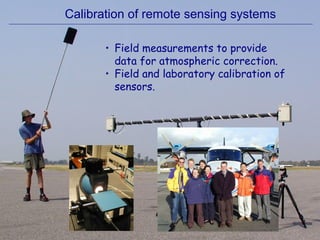
1. Calibration of remote sensing systems
• Field measurements to provide
data for atmospheric correction.
• Field and laboratory calibration of
sensors.
2. Validation of EO data products
Biomonitoring of Volatile Organic Compounds (VOC)
• Approached by Infoterra Ltd to investigate whether the
spectral reflectance of common plant species is affected
by exposure to VOCs.
• Client : Astra Zeneca PLC (manuf. plant in Macclesfield).
control
treated
treated
control
Reported results from Astra-Zeneca pilot study
3. Methods : joint field expt with CEH Edinburgh
• Six Open-Top
Chambers (OTC)
• VOC concentrations
carefully controlled
• Plants grown in trays
• Moved indoors to
measure spectra
• 3 OTC = treatment
• 3 OTC = controls
• 15 plants per species in each
• Measured twice during season
4. Over 1000 leaf specimens were measured
VOCs : a mixture of Acetone (0.03 mg m-3
),
Acetonitrile (0.0008 mg m-3
), Dichloromethane (0.0008 mg m-3
),
Ethanol (IMS) (0.004 mg m-3
), MTBE (0.025 mg m-3
)
and Toluene (0.0015 mg m-3
).
Large database of high quality reflectance spectra...
5. Karen at the beginning of the experiment...
and after measuring her 1000th
dandelion leaf...
6. 0
10
20
30
40
50
60
400 800 1200 1600 2000 2400
Mean reflectance of leaves from control and treated
Dock plants in July. Samples collected from visually
senescent leaves have been omitted to demonstrate
that mean reflectance of treated and control green
leaves is very similar across all wavelengths measured.
Treatment
Control
Reflectance(%)
Wavelength (nm)
7. control
treated
treated
control
• Stray light error within the spectroradiometer?
• Incorrect removal of the dark current?
• One for the Journal of Irreproducible Results...
Highlights the need to establish protocols and publicise best
practice if remote sensing is to be trusted as a scientific tool.
8. Network for Calibration and Validation of
Earth Observation data
• Knowledge transfer network.
• Around 25 partners - universities,
industry and government.
• Disseminate best practice through
meetings, website & field experiments.
12. Aims of NCAVEO 2006 Experiment
• To determine the accuracy and precision of radiance and
reflectance products derived from airborne and
satellite sensors (e.g. CASI, CHRIS/PROBA, SPOT).
• To validate examples of three products derived from EO
data:
• Leaf Area Index map
• Vegetation Index map (MTCI)
• Land Cover map
• To document and share emergent best practice in EO
product validation.
• To consolidate and grow the community of data
providers and users interested in quality assurance of
EO data products.
• To investigate the feasibility of establishing a long-term
calibration & validation site in southern England.
Welcome to this meeting to begin to plan the 2006 NCAVEO Field Experiment. The NCAVEO Steering Cttee felt that in addition to annual meetings and the forthcoming conference on cal/val (Dec 2006), there should be an opportunity for some hands-on knowledge transfer. Hence this community-led experiment.
The orginal plan was to use the Barton Bendish site in Norfolk. Problems with that led to a move to Chilbolton in Hampshire. The area is chalk download south-west of Basingstoke. A wild and desolate part of southern England (relatively speaking...).
Welcome to this meeting to begin to plan the 2006 NCAVEO Field Experiment. The NCAVEO Steering Cttee felt that in addition to annual meetings and the forthcoming conference on cal/val (Dec 2006), there should be an opportunity for some hands-on knowledge transfer. Hence this community-led experiment.