1. New Mexico Geological Society Guidebook, 64th Field Conference, Geology of Route 66 Region: Flagstaff to Grants, 2013, p. 205-213
SPRINGS ON THE ZUNI RESERVATION
205
RECHARGE SOURCES AND CHARACTERISTICS OF SPRINGS
ON THE ZUNI RESERVATION, NEW MEXICO
1
Paul G. Drakos1, Jim W. Riesterer1, and Kirk Bemis2
Glorieta Geoscience, Inc., PO Box 5727, Santa Fe, NM 87501, drakos@glorietageo.com
2
Zuni Conservation Program, PO Box 339, Zuni, NM 87327
ABSTRACT—Relatively high-volume springs (100-300 gpm; 6-19 l/s) discharge from the Permian San Andres-Glorieta
(Psg) aquifer and interconnected Quaternary alluvium and fractured basalt (Qal/Qb) aquifers on the Zuni Reservation in westcentral New Mexico. Psg springs in the Nutria area, near the recharge source in the Zuni Mountains, exhibit a mixture of
modern (<5-10 year old) and pre-1952 recharge, indicating spring discharge from shallow and deep circulation systems near
the mountain front. Psg springs in the Ojo Caliente area are fen-type springs that represent predominantly or entirely pre1952 recharge. Stable isotope (δ18O and δ2H) data are consistent with high elevation, winter precipitation recharge for Nutria
Psg springs and a lower elevation North Plains/Continental Divide recharge source southeast of the reservation for the Ojo
Caliente springs. Alluvial springs in the Black Rock area exhibit lower-elevation, modern recharge, whereas discharge from
Pescado-area alluvial springs exhibit higher-elevation, predominantly pre-1952 recharge. The recharge source for Pescado
springs is likely winter precipitation in the Zuni Mountains, whereas Black Rock alluvial springs have local recharge sources
on uplands within the reservation. Springs in both areas discharge from an interconnected alluvial/fractured basalt flow system.
Springs discharging from the Rock Point Fm/Zuni sandstone aquifer exhibit variable recharge, with some receiving rapid
recharge from winter precipitation and others receiving older recharge from summer monsoonal precipitation.
Spring discharge measurements collected during 2007-2009, when compared to earlier studies by Orr (1987) and Summers
(1972), suggest a generally declining trend in spring flows between 1972 and 2009. This apparent decline in spring discharge
could be due to increased groundwater diversions in the Zuni Mountains, Zuni River basin, and regionally in the Psg aquifer,
fluctuations in precipitation, variations in measurement methodologies, or a combination of these factors. Increasing spring
flows after 2009 correspond to above-normal winter precipitation, particularly snow moisture content, recorded at one precipitation station and three snow courses in the recharge area.
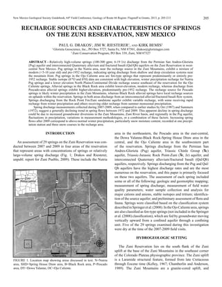
INTRODUCTION
An assessment of 29 springs on the Zuni Reservation was conducted between 2007 and 2009 in four areas of the reservation
that represent areas with concentrations of springs or relatively
large-volume spring discharge (Fig. 1; Drakos and Riesterer,
unpubl. report for Zuni Pueblo, 2009). These include the Nutria
area in the northeastern, the Pescado area in the east-central,
the Dowa Yalanne-Black Rock-Spring House Draw area in the
central, and the Ojo Caliente area in the southwestern part
of the reservation. Springs discharge from the Permian San
Andres-Glorieta (Psg) aquifer, Triassic Chinle Group ( c)
aquifer, Triassic-Jurassic Rock Point-Zuni ( r, Jz) aquifer, and
interconnected Quaternary alluvium/fractured basalt (Qal/Qb)
aquifers, respectively. Springs discharging from the Psg and Qal/
Qb aquifers have the highest discharge rates and are the most
numerous on the reservation, and this paper is primarily focused
on these two aquifers. The assessment of each spring included
some or all of the following: geologic and geomorphic mapping;
measurement of spring discharge; measurement of field water
quality parameters; water sample collection and analysis for
major cations and anions, stable isotopes and tritium; identification of the source aquifer; and preliminary assessment of flora and
fauna. Springs were classified based on the classification system
described in Springer et al. (2008). In the Ojo Caliente area, springs
are also classified as fen-type springs (not included in the Springer
et al. (2008) classification), which are fed by groundwater moving
vertically upward from a confined aquifer through a confining
unit. Five of the 29 springs examined during this investigation
were dry at the time of the 2007-2009 field visits.
Hydrogeologic Setting
FIGURE 1. Location map showing areas discussed in text. N=Nutria
area, SHD=Spring House Draw area, B=Black Rock area, P=Pescado
area, DY=Dowa Yalanne, OC=Ojo Caliente.
The Zuni Reservation lies on the south flank of the Zuni
uplift at the base of the Zuni Mountains in the southeast corner
of the Colorado Plateau physiographic province. The Zuni uplift
is a Laramide structural feature, formed from late Cretaceous
through Eocene time (Kelley, 1967; Chamberlin and Anderson,
1989). The Zuni Mountains are a granite-cored uplift, and
2. DRAKOS, RIESTERER, and BEMIS
206
overlying sedimentary rocks range in age from Permian to
Cretaceous (Fig. 2; Hackman and Olson, 1977). The sedimentary
sequence is deformed into a large, northwest-trending asymmetrical dome by the Zuni uplift. The Nutria monocline, in the
northeast corner of the reservation, is a prominent fold bordering the southwest side of the Zuni uplift. The remainder of the
reservation is underlain by a series of northwest-trending
anticlinal and synclinal structures formed during Laramide deformation (Orr, 1987). The majority of springs on the reservation
discharge from the Permian San Andres-Glorieta aquifer, the
Triassic-Jurassic Point Rock Formation/Zuni Sandstone aquifer,
and the interconnected Quaternary alluvium and fractured
Quaternary basalt aquifers, described below.
Permian San Andres-Glorieta Aquifer (Psg)
The Permian San Andres-Glorieta Aquifer (Psg) consists
of hydrologically connected sandstone (Glorieta Sandstone)
and overlying limestone (San Andres Limestone) that locally
produces significant water, especially where fracturing and
dissolution of the limestone enhance groundwater flow (Orr,
1987). Groundwater flow in the Psg aquifer in the southeastern and east-central portion of Zuni Reservation is generally
from east to west at 0.004 ft/ft. In the northeastern part of the
Reservation near Nutria flow is from northeast to southwest at
0.08 ft/ftand in the western part of the reservation flow is from
southeast to northwest at approximately 0.009 ft/ft (Orr, 1987).
Several springs discharge from the Psg aquifer in the Nutria and
Ojo Caliente areas, with flow rates of up to 50 gpm (3.2 l/s) and
250 gpm (16 l/s), respectively. The Psg aquifer is likely in hydrologic communication with the underlying Yeso Formation (Py)
aquifer in the vicinity of the Zuni Reservation.
Triassic Rock Point/Jurassic Zuni Sandstone aquifer
The Rock Point Formation (formerly Rock Point Member of
the Wingate sandstone, subsequently redefined as the Rock Point
Member of the Chinle Formation and now elevated to Formation
status as part of the Chinle Group (Orr, 1987; Lucas and Hayden,
1989; Heckert and Lucas, 2003)) overlies the Chinle Formation
throughout the Reservation, and consists of fine-grained sandstone, fluvial siltstone and silty mudstone (Orr, 1987; Lucas
and Hayden, 1989). In exposures along the Nutria monocline a
chert and quartzite pebble conglomerate exists near the base of
the Rock Point Formation. In exposures near the base of Dowa
Yalanne the Rock Point Formation is a parallel-bedded, ledgey
sandstone overlying the Owl Rock Formation (Drakos and
Riesterer, unpubl. report for Zuni Pueblo, 2009). The Jurassic
Zuni sandstone is a massive, cross-bedded, eolian sandstone that
forms prominent cliffs where it is capped by the Dakota sandstone. Dowa Yalanne (DY), a large mesa in the central portion of
the reservation, is the type section of the Zuni Sandstone (Lucas
and Heckert, 2003). The Rock Point/Zuni Sandstone aquifer is
locally in hydrologic communication with interbedded shale
and thin limestone beds of the underlying Owl Rock Formation.
Several relatively low-flow springs discharge from the Rock
Point/Zuni sandstone aquifer near the base of Dowa Yalanne, the
Nutria Monocline, and the Spring House Draw area.
Quaternary Alluvium/Fractured
Basalt Aquifer
FIGURE 2. Schematic stratigraphic section and description of lithologic
units underlying the Zuni Reservation. Thicknesses and descriptions
modified from Orr (1987) and Heckert and Lucas (2003). Abbreviations:
Q=Quaternary, Perm.=Permian, s=sand, g=gravel, si=silt, sis=siltstone,
c=clay, SS=sandstone, LS=limestone, sh=shale.
Alluvial deposits are present throughout the reservation along
the major drainages (Rio Nutria, Rio Pescado, Zuni River) and
their smaller tributaries. The alluvium consists of unconsolidated or semi-consolidated sand, gravel, silt, and clay, with the
composition varying based on the bedrock materials exposed at
the surface nearby. Basalt flows overlie or are interbedded with
the alluvium along the Pescado and Zuni River drainages, where
the basalt and alluvium form an interconnected aquifer. Groundwater flow in the alluvial aquifer along the upper Zuni River and
the Rio Pescado is from east to west, at 0.006 ft/ft (Orr, 1987).
Ground water flow in the alluvial aquifer along the lower Zuni
River and the Rio Pescado is from northeast to southwest, at
0.003 ft/ft (Orr, 1987). Several large springs in the Pescado and
Black Rock areas discharge from the alluvial/basalt aquifer.
3. SPRINGS ON THE ZUNI RESERVATION
207
san andres-glorieta springs
Nutria Area
The sedimentary sequence in the vicinity of Nutria is deformed
into the Nutria monocline and a prominent hogback formed by
Cretaceous through Triassic beds that dip steeply to the southwest (Fig. 3). At least seven springs are inferred to discharge from
the Psg aquifer east of the hogback (Fig. 4). During field visits
conducted between 2007 and 2009 five of the springs were dry,
two (Nutria Main and Nutria Canyon Wall) were flowing, and
one (Bird Spring) was a seep during an initial visit and dry on a
follow up visit. Summary data from the Nutria area springs are
contained in Table 1.
Nutria main spring is classified as a rheocrene spring, with flow
emerging in an active stream channel. Flow at the Nutria main
spring was measured by pumping water out of an underground
vault where the spring orifice is located and measuring the time
required for the vault to recharge after it had drained. Estimated
discharge varied with head (slowing as the vault filled), ranging
between 50 and 90 gallons per minute (gpm) (3.2 to 5.7 liters per
second [l/s]).
Nutria canyon wall spring is a contact or hanging garden spring
that emerges as a series of seeps from a bedding contact within
the Glorieta Sandstone. Flow from the numerous seeps collects in
a large pool which contributes flow to the Rio Nutria. Combined
flow from the seeps along the wall was visually estimated as 1 to
5 gpm (0.06 to 0.3 l/s).
Lonjose SW is a hypocrene spring, where flow does not reach
the surface. Water was encountered in a hand-augered boring 61
cm (2 ft) below ground surface (bgs).The orifice (dry in 2009)
emerges in alluvium overlying the Chinle Formation, but the
source for the spring is interpreted to be the underlying Psg based
on the geologic setting and geochemistry results discussed below.
Indian Spring was not flowing during the time period of this
investigation. However, a spring flow of < 1l/s was observed
FIGURE 3. Cross-section through the Nutria Monocline. Location of
cross-section is shown in Figure 4. Kg=Gallup Sandstone, Km=Mancos
Shale, Kd=Dakota Sandstone, Jz=Zuni Sandstone, r=Rock Point
Fm., c=Chinle Group undifferentiated, Psa=San Andres Limestone,
Pg=Glorieta Sandstone, Py = Yeso Fm., Pa = Abo Fm.
FIGURE 4. Preliminary geologic map of the Upper Nutria area, showing
spring locations, geology mapped during field investigations, and location of cross-section A-A’ (Figure 3). Qal=Alluvium, Qc=Colluvium,
Kc=Crevasse Canyon Fm., Kg=Gallup Sandstone, Km=Mancos Shale,
Kd=Dakota Sandstone, Jz=Zuni Sandstone, r=Rock Point Fm.,
c=Chinle Group undifferentiated (includes thin Moenkoepi Fm at
base), Psa=San Andres Limestone, Pg=Glorieta Sandstone
4. DRAKOS, RIESTERER, and BEMIS
208
TABLE 1. Data collected from springs on the Zuni Reservation.
Major cation/anion concentration, mg/L*
Date
Ca Mg Cl HCO3 SO4 TDS 3H (TU)
Measured Na K
11/7/07
9.2 <1.0 79 18 5.9 317
43
340 <1.1
δ18O
(‰)
-12.6
δ2H
(‰)
-91
11/7/07
8/27/09
5/7/08
5/7/08
5/7/08
5/8/08
5/6/08
8/28/09
5/6/08
11/8/07
11/8/07
11/8/07
11
7.8
49
51
53
27
38
41
39
48
81
85
<1.0
0.1
4.6
4.7
5.3
2.6
2.9
5
2.8
1
2.9
4.5
75
92
130
160
130
110
39
41
41
43
89
130
-11.5
-12.6
-10.4
-10.5
-10.6
-9.5
-12.2
-12.1
-12.1
-11.4
-10.2
-4.6
-85
-92
-74
-74
-75.8
-69
-90
-90
-89
-83
-79
-50
Nutria Cyn Wall
Lonjose SW
Sacred
Ojo Caliente Big
Rainbow
Plumasano Wash
Pescado South #3
Upper Pescado††
Lower Pescado
Black Rock
Black Rock North
Black Rock BIA
Flow, gpm
Source Aquifer (l/s)
Psg
50-90 (3.25.7)
Psg
1-5 (0.06-0.9)
Psg
0 (piezometer)
Psg
128 (8.1)
Psg
15 (0.9)
Psg
220 (13.9)
Psg
55 (3.5)
Qal/Qb
65 (4.1)†
Qal/Qb
185 (11.7)
Qal/Qb
120 (7.6)
Qal/Qb
Unknown
Qb±Qal
2.3 (0.1)
Qal/Qb, cu (?) Unknown
SHD #13
Grasshopper HB
Jz/ r
<1 (<0.06)
<1 (<0.06)
10/8/08
10/7/08
18
15
ND
1.4
DY North†††
Jz/ r/ o
<1 (<0.06)
10/8/08
50
DY South
Jz/ r
2 (0.1)
10/8/08
43
Unknown
10/9/08
Spring Name
Nutria Main
Chavez
Qal/Jz
cu
21
26
38
39
41
13
13
12
14
4
17
20
6.2
4
34
34
33
47
9.5
10
10
6.9
18
57
293
390
342
329
341
390
232
310
232
244
366
512
64
23
280
280
280
310
22
26
24
22
140
68
350
370
770
770
1100
850
270
300
280
240
540
640
2.5±0.27
2.3±0.27
<0.7
<0.8
<0.5
<0.9
0.8±0.23
<0.9
1.1±0.25
3.1±0.28
4.1±0.31
5.9±0.26
150 12
67 9.3
15 537
7.1 268
9.6
6.6
500
260
6.2±0.4 -10.6
3.1±0.35 -12.3
-74
-91
0.8
29
3.6
20
183
6.3
220
<0.5
-76
1.4
54
6.3
16
268
6.4
270
0.8±0.32 -10.2
-77
120 3.1
70
6.6
93
268
40
550
2.0±0.37 -9.5
-75
-9.7
Qal=Alluvium, Qb=Basalt, Jz=Zuni Sandstone, r=Rock Point Formation, cu=Undifferentiated Chinle Group, Psg=San Andres-Glorieta, SHD=Spring House Draw, DY=Dowa Yalanne
* CaCO3 was non-detect for all samples
† Combined flow from Pescado South springs #1-4
†† General chemistry sample collected on 6/9/04, reported in Eib et al. (unpubl. report for NM Environment Department, 2004)
††† Discharge observed from basal Point Rock Fm and from Owl Rock Fm ( o)
at Indian Spring during a subsequent investigation conducted
in 2011, and an analysis of geochemistry data indicated a Yeso
source for this spring (Banteah et al., unpubl. report for University of New Mexico, 2011).
fining unit. In addition, numerous seeps, originating from the
Psg aquifer, discharge from the Moenkopi Formation and basal
Chinle Group along Plumasano wash. Combined flow from these
seeps was measured at 55 gpm (3.5 l/s) on May 8, 2008.
Ojo Caliente Area
Rock Point/Zuni Sandstone
aquifer SPRINGS
The Ojo Caliente area is situated in the southwest corner of
the reservation along the north-trending, gently plunging Ojo
Caliente anticline (Fig. 5; Orr, 1987). The Psg aquifer is uplifted
to near the surface along the fold axis (Orr, 1987). Fracturing of
the overlying Chinle Formation along the fold axis is the likely
mechanism that allows discharge from the confined Psg aquifer
to reach the surface. Springs in the Ojo Caliente area had discharge rates ranging from 15 to 220 gpm (0.9 to 13.9 l/s) on May
7, 2008, including Rainbow Spring (220 gpm; 13.9 l/s), Sacred
Spring (128 gpm; 8.1 l/s), and Big Spring (15 gpm; 0.9 l/s) (Fig.
5). Extensive Pliocene (?) travertine deposits cap thin MiocenePliocene Bidahochi sand and gravel deposits overlying Chinle
Group shale above Rainbow and Sacred Spring (Fig. 6). These
travertine deposits demonstrate that this has been an area of
spring discharge for an extended period of time and are indicative
of CO2 degassing from groundwater (e.g. Crossey et al., 2011).
Ojo Caliente-area Psg springs are warm (18 to 22°C) fen-type
or limnocrene springs that emerge in pools, fed by groundwater
moving vertically upward from a confined aquifer through a con-
Dowa Yalanne Area
Dowa Yalanne is a prominent mesa underlain by Zuni Sandstone cliffs capped by Dakota Sandstone, situated in the central part of the reservation, south of Black Rock (Fig. 1). The
Zuni Sandstone is underlain by Rock Point Formation finegrained, ledgey sandstone, which forms the lower slopes of
Dowa Yalanne. Two contact springs (DY North and DY South)
discharge from Owl Rock Formation limestone or sandstone
beds, and/or sandstone beds at the base of the Rock Point
Formation near the base of Dowa Yalanne mesa. Although
spring discharge is observed from the Owl Rock Formation as
well as the basal Rock Point Formation, it is interpreted that
groundwater flow is primarily through the Rock Point/Zuni Sandstone aquifer. Flow from each of these springs is 2 gpm (0.1 l/s)
or less, and DY North forms a hanging garden spring. The DY
springs are recharged by precipitation and/or snowmelt on top of
Dowa Yalanne mesa.
5. SPRINGS ON THE ZUNI RESERVATION
Spring House Draw Area
Spring House Draw is a narrow drainage that cuts through
cliffs of Zuni Sandstone in the central part of the reservation (Fig.
1). Spring House Draw (SHD) is bedrock floored in some places
and covered by a thin veneer of Quaternary alluvium throughout
much of its course. Seeps near the base of the Zuni Sandstone discharge into valley floor alluvium and subsequently emerge from
the alluvium as rheocrene springs, therefore forming an interconnected Zuni Sandstone-alluvial aquifer. Numerous low-flow
SHD springs are recharged by precipitation on top of mesas that
lie on either side of the drainage. Most are seeps with discharge
of less than 0.1 gpm (0.006 l/s).
Nutria Area
Springs or seeps discharge from the Zuni Sandstone/Rock
Point Formation aquifer on the east side of the Hogback formed
by the Nutria Monocline. The greatest discharge measured was
less than 0.2 gpm (0.01 l/s) at Grasshopper Hogback spring.
Springs in this area are apparently recharged by precipitation falling on the Hogback.
Quaternary Alluvium/Fractured Basalt
Aquifer springs
209
The alluvium and fractured basalt form an interconnected aquifer
system, and springs discharge along the margins or at the terminus of basalt flows in the Pescado area. These springs include
Pescado South #1, 2, 3, and 4 on the south side of the valley, and
Upper and Lower Pescado Springs in the central to north side of
the valley. All of the springs in the Pescado area were flowing in
2007-2009. Spring discharge ranged from a combined flow of 65
gpm (4.1 l/s) from Pescado South 1-4 springs to 185 gpm (11.7
l/s) in Upper Pescado Spring. Flow from Lower Pescado spring
was 120 gpm (7.6 l/s).
Black Rock Area
The Black Rock area is situated in the central part of the reservation, near the confluence of Spring House Draw and the Zuni
River (Fig. 1). Quaternary basalt flows are present both in the
subsurface and on the valley floor, interbedded with and overlying Zuni River alluvial deposits. In a setting similar to the
Pescado area, alluvium and basalt form an interconnected aquifer
system, and several springs discharge from the margins of basalt
flows or from alluvium overlying the Chinle Group in the Black
Rock area. These springs include Black Rock and Black Rock
BIA springs, which have been used in the past as a local water
supply. Black Rock spring had an estimated flow of 50-75 gpm
(3.2 to 4.7 l/s) (Orr, 1987).
Pescado Area
Pescado is situated along the Rio Pescado valley near the
eastern reservation boundary (Fig. 1). Quaternary basalt flows
are present both in the subsurface and on the valley floor, interbedded with and overlying alluvial deposits of the Rio Pescado.
FIGURE 5. Map of the Ojo Caliente area showing spring locations and
approximate trace of the Ojo Caliente anticline.
FIGURE 6. Geologic map and cross-section of Sacred Spring.
6. DRAKOS, RIESTERER, and BEMIS
210
Geochemistry
Water Quality Analysis Suite
Samples collected from springs included in the study were
analyzed for major cations (calcium, magnesium, potassium,
sodium), anions (carbonate-bicarbonate, fluoride, chloride,
bromide, nitrate-nitrite, phosphorus, and sulfate), and total dissolved solids (TDS) by Hall Environmental Laboratory (HEAL)
in Albuquerque, NM. Samples were also analyzed for the stable
isotopes of oxygen (18O) and deuterium (2H), and for tritium (3H)
by the University of Arizona Laboratory of Isotope Geochemistry
in Tucson, AZ. Samples were collected from Rainbow Spring in
2005, and from all other springs in 2007 and 2008.
Major Cations and Anions
Major cation (Ca2+, Na+, Mg2+, and K+) and anion (Cl-, SO42-,
HCO3-, and CO32-) data from samples collected for this study were
compiled and plotted on a Piper diagram to determine geochemical characteristics of the source aquifers (Fig. 7). Major element
chemistry data for spring samples are summarized in Table 1.
Samples collected from the Psg aquifer in the Nutria area
(Nutria Canyon Wall, Nutria Main, and Lonjose springs) near
the recharge zone are a Ca-Mg-HCO3 water type, whereas Psg
springs in the Ojo Caliente area (Rainbow, Sacred, Plumasano
Wash and Big springs) are a Ca-Mg-SO4-HCO3 water type
(Fig. 7). The higher sulfate in the Ojo Caliente springs relative
to Nutria springs corresponds to longer residence time in the
Psg aquifer and interaction with gypsum or anhydrite within
the San Andres limestone, or indicates that the Psg aquifer is in
hydrologic communication with the underlying Yeso Formation
aquifer, which contains gypsum beds in the upper part of the
Formation (Colpitts, 1989). Ojo Caliente springs have higher
FIGURE 7. Piper diagram (Piper, 1944) of major cations and anions
from springs on the Zuni Reservation. DYN=Dowa Yalanne North
spring, SHD#13=Spring House Draw #13 spring.
TDS (770 to 1100 mg/l) than Nutria area springs (TDS of 340 to
370 mg/l), consistent with a longer residence time for groundwater discharging at the Ojo Caliente springs. Samples collected
from the majority of alluvial springs for this investigation are
similar to one another in geochemical composition, with Ca +
Na ± Mg as the dominant cations and bicarbonate as the dominant anion in all but one sample (Fig. 7). Water in the Zuni
Sandstone-Rock Point Formation aquifer exhibits an evolution
from Ca-HCO3 water type to a Na-Ca-HCO3 water type with
increasing travel time in the aquifer (Fig. 7; Table 1).
Isotope Geochemistry
Tritium Isotopes
Tritium, 3H, is a short-lived isotope produced in abundance
within the last 50 years during atmospheric testing of hydrogen bombs. The peak in tritium concentration in precipitation
occurred in 1963 and has declined rapidly since that time. Due
to its relatively short half-life of 12.32 years, the presence of
elevated tritium in groundwater indicates a post-1952 recharge
source. Bomb-generated tritium rained out in the 1970s and
1980s, and tritium concentrations had stabilized in the atmosphere
by 1992 (Eastoe et al., 2012). Post-1992 tritium values range
from 6+/-1 TU in Tucson (Eastoe et al., 2004) to around 10 TU in
Albuquerque (Plummer et al., 2004), and streams draining the
Sangre de Cristo Mountains near Taos exhibit tritium concentrations ranging from 8 to 11 TU (Drakos et al., 2004). A tritium
concentration of approximately 10 TU would therefore be a good
estimate for precipitation in the Zuni Mountains.
Prior to 1992, according to the model of Doney et al. (1992),
the decline of tritium in rainfall was a close approximation to a
decay curve after 1970. Therefore, all rain that fell during the
1970s and 1980s would also have had about 10 TU in Zuni in
1992, provided it didn’t mix with water of other ages, and tritium
in 1970-1992 water would decay according to the decay function
of tritium with an initial concentration of 10 TU in 1992. Such
water would have about 4 TU by 2007-2008. Water with < 4 TU
would therefore have been mixed with pre-bomb water, including many of the springs sampled in this investigation. Water with
< 1.5 TU likely represents predominantly pre-1952 recharge with
<20% 5 TU rainwater (Eastoe et al., 2004). Water with ≥ 4 TU but
≤ 10 TU represents modern (< 5 to 10 year old recharge). Water
with > 10 TU tritium indicates the presence of some “bomb”
tritium from the 1950s-1970s. The interpretation of tritium data
for this study can therefore be summarized as follows:
Non-detectable tritium, <0.5 to <1.1 TU predominantly or entirely
pre-1952 recharge
Detectable tritium, < 1.5 TU
predominantly pre-1952
recharge
Detectable tritium, 1.5 TU to > 4 TU mixture of pre-1952 and
modern recharge
Detectable tritium, 4 TU to 10 TU
modern (< 5-10 yr old
recharge)
Detectable tritium, > 10 TU
some bomb tritium present
7. SPRINGS ON THE ZUNI RESERVATION
Based on tritium results, Black Rock area alluvial springs
have modern (likely less than 5 year old) recharge (tritium values
ranging from 4 to 6 TU), or exhibit a mixture of modern and
pre-1952 recharge (tritium value of 3.1 TU). Discharge from
Pescado area springs represents predominantly pre-1952 recharge
(tritium values ranging from <0.8 to 1.1 TU) (Table 1). These data
indicate that water discharging from Pescado-area springs has a
longer residence time in the alluvial/fractured basalt flow system;
whereas water discharging from Black Rock alluvial springs have
a shorter residence time and likely local recharge sources.
Tritium concentrations in samples collected from Ojo Caliente
springs that discharge from the Psg aquifer are less than 0.9 TU
(<0.5 to <0.9 TU), indicating that springs in the Ojo Caliente area
exhibit predominantly or entirely pre-1952 recharge. Springs in
the Nutria area, located much closer to the recharge source in
the Zuni Mountains, exhibit a mixture of pre-1952 and modern
recharge (Nutria Canyon Wall spring and Lonjose SW spring, tritium concentrations are 2.3-2.5 TU) or represent predominantly or
entirely pre-1952 recharge (Nutria Main spring, <1.1 TU). These
data are generally consistent with younger recharge and shorter
travel times from springs in the Nutria area and older recharge
and longer travel times for springs in the Ojo Caliente area. As
discussed above, the general chemistry of the springs shows an
evolution from a Ca-Mg-HCO3 water type in the Nutria area, near
the Zuni Mountains recharge zone to a Ca-Mg-SO4-HCO3 water
type in the Ojo Caliente area. Ojo Caliente spring recharge may
be dominated by aquifer recharge in the North Plains, and may
have much longer residence times. The low tritium concentration
in the Nutria Main spring indicates a longer residence time (± 55
years) and possibly deeper circulation for water discharging from
this spring than for other springs in the Nutria area; however, the
Nutria Main spring geochemistry is similar to the other Nutria
springs. This may indicate that Ojo Caliente springs represent
recharge that is much older (on the order of 100 to 1000 years),
and the age differences between the Nutria area springs is small
by comparison.
Tritium concentrations in the Jz/ r aquifer range from 6 to <
0.5 TU, indicating aquifer residence times ranging from less than
5 to 10 years (SHD and Nutria Hogback areas) to greater than 55
years (DY North spring). When compared to the Piper plot (Fig.
7), higher tritium concentrations and shorter aquifer residence
time corresponds to a Ca-HCO3 water type, whereas lower tritium
concentrations and longer aquifer residence time corresponds to a
Na-Ca-HCO3 water type. These data show an evolution in water
chemistry resulting from water-rock interaction (Drever, 1982,)
in the Jz/ r aquifer.
Oxygen-Deuterium Isotopes
Data from springs sampled in this investigation are plotted
against the Global, Placitas, and Santa Fe Meteoric Water Lines
(Fig. 8). The majority of springs sampled plot along the global
meteoric water line (Fig. 8). These data are consistent with snowmelt or non-monsoonal precipitation as a recharge source. Two of
the Black Rock alluvial springs, the Dowa Yalanne Jz/ r springs,
and the Chinle (Chavez) spring plot along a line with a slope of
211
5.7 (Global Meteoric Line slope = 8.13, Placitas Meteoric Line
slope = 7.7), indicating evaporative enrichment (Mazor, 1991;
Clark and Fritz, 1997).This is suggestive that recharge to these
springs is dominated by summer monsoonal precipitation, either
via infiltration along stream channels or direct infiltration.
Samples from Nutria Main and Lonjose SW springs are
depleted in δ18O and δ2H relative to samples collected from
Ojo Caliente Psg springs. These data suggest higher elevation
(approximately 2400 to 2600 m) recharge in the Zuni Mountains
as a water source for the Nutria Psg springs (with the exception of
Nutria Canyon Wall spring) and a lower elevation (approximately
2200 m) North Plains/Continental Divide recharge source east
and/or southeast of the reservation as a recharge source for the
Ojo Caliente springs.
The difference in δ18O and δ2H signatures between Spring
House Draw #13/Grasshopper Hogback and Dowa Yalanne
springs is an unexpected result. All springs appear to have a local
recharge source located at a similar elevation (Dowa Yalanne and
Spring House Draw mesa tops have an elevation of around 7200
ft (2200 m); the top of the Nutria Monocline hogback is around
7300 ft (2225 m)). Despite the similar elevation of their respective recharge areas, it appears that Grasshopper Hogback/SHD
#13 receive recharge from snowmelt or winter precipitation,
whereas DY North and DY South receive recharge from summer
monsoonal precipitation.
Pescado area alluvial springs are lower in δ18O and δ2H values
relative to Black Rock alluvial springs, indicating a higher-elevation recharge source for Pescado springs. Stable isotope and
tritium data (discussed above) are therefore consistent with, and
indicate, a recharge source in the Zuni Mountains for Pescado
FIGURE 8. Plot of δ18O vs. δ2H for springs on the Zuni Reservation. SFMWL=Santa Fe meteoric water line (Anderholm, 1994),
GMWL=Global meteoric water line (Craig, 1961), PMWL=Placitas
meteoric water line (Johnson et al., 2002), Evap=evaporative trend
toward Black Rock BIA spring where δ18O=-4.6 and δ2H=-50 (not
shown on graph). Springs: a=Nutria Main, b=Lonjose SW, c=Grasshopper
Hogback, d-f=Pescado, g=Nutria Canyon Wall, h=Black Rock,
i-Rainbow, j=Spring House Draw #13, k=Big, l=Sacred, m=Dowa
Yalanne South, n=Black Rock North, o=Dowa Yalanne North,
p=Plumasano Seeps, q=Chavez.
8. DRAKOS, RIESTERER, and BEMIS
212
area springs, and local recharge sources on uplands within the
reservation for Black Rock alluvial springs.
Recharge to the
Aquifer System
Recharge to the aquifer system that discharges at springs
discussed in this study occurs via snowmelt and direct
precipitation in the Zuni Mountains northeast of the reservation,
on mesa tops and uplands within the reservation, via direct precipitation and infiltration through fractured basalt flows in the
North Plains area east of the reservation, and through infiltration
along stream channels. Snowmelt and direct precipitation in the
Zuni Mountains, which reach an elevation of over 9000 ft (2700
m), are a source of direct recharge to the Psg and Yeso aquifers.
The Psg aquifer also receives recharge via direct precipitation
and infiltration through fractured basalt flows in the North Plains
area east of the reservation (Orr, 1987). Precipitation in the Zuni
Mountains is also a recharge source for alluvial aquifers along
the main stream systems on the reservation (the Nutria, Pescado,
and Zuni Rivers).
Snowfall and precipitation along the Nutria monocline, as
well as infiltration from streams flowing across the monocline,
are recharge sources for the Zuni-Rock Point sandstone aquifer.
Additional recharge to the Zuni-Rock Point aquifer occurs via
direct precipitation and snowmelt onto uplands and mesa tops situated at elevations of 7000 to 7400 feet (2130 to 2260 m) located
throughout the eastern two-thirds of the reservation.
Spring Discharge Trends
Measurements of spring discharge were conducted for the
majority of springs visited during this investigation. These data
are compared to spring flow measurements from Orr (1987) and
Summers (1972). Based on these measurements, spring flows
show a declining trend between 1972 and 2009. In the Ojo
Caliente area, Summers (1972) reported 500-1500 gpm (32-95
l/s) for combined Ojo Caliente spring discharge, Orr (1987)
measured 545 gpm (34 l/s) average combined discharge from
Rainbow, Big, and Sacred springs in May 1980, and a combined
flow of 365 gpm (23 l/s) was measured in May 2008. Similar
trends were observed for Pescado Springs (combined Upper
and Lower Pescado spring discharge of 470 gpm (302 l/s) in
August 1979 versus 305 gpm (19 l/s) in August 2009), and the
Nutria area, where several springs previously utilized by local
ranchers were dry during 2007-2009. This apparent decline in spring
discharge on the reservation between 1972 and 2009 could be
due to increased groundwater diversions in the Zuni Mountains,
the Zuni River basin, and regionally in the Psg aquifer resulting in depletion effects on springs, fluctuations in precipitation,
variations in measurement methodologies, or a combination of
these factors.
During subsequent visits to the five Nutria Psg springs that
were dry during the 2007-2009 study, the Zuni Conservation
Program observed that four springs started flowing again in May
2010. Past observations revealed that at least two of these springs
were flowing in 1995. Analysis of data from one precipitation
station and three snow courses in the recharge area indicates that
winter precipitation, especially snowpack moisture content, significantly affects recharge for these springs. For January 2010,
the precipitation station measured more than twice its mean
precipitation and the most snowfall, approximately three times its
mean, for January over its period of record, 1923-2012 (WRCC,
2012). For March and April 2010, each snow course had its highest snow water equivalent (SWE) for those respective months
for its period of record (1994-2012 for Boon and Dan Valley
stations and 1999-2012 for McGaffey) (NRCS, 2012). From
January through April 2010, the monthly SWE percent of mean
at all three snow courses increased each month from just greater
than their monthly means in January (the first month reported)
to between five and more than ten times their monthly means in
April (the last month reported). For each snow course and each
reported month, the cumulative departure from mean (CDFM)
SWE exhibits a drying trend from the start of record until
2006-2009, in general, when a wetting trend begins through 2010,
as illustrated for March in Figure 9. A similar CDFM analysis of
the precipitation station data was limited by a significant amount
of missing data, especially after 1999 (NCDC, 2012).
Conclusions
Springs discharge from the Psg aquifer in the Nutria and Ojo
Caliente areas of the Zuni Reservation, with typical flow rates
between 15 and 220 gpm (0.9 and 13.9 l/s) measured during site
visits in 2007-2009. Nutria springs are recharged in the Zuni
Mountains, and groundwater discharging at Nutria represents a
mixture of modern and pre-1952 recharge. Ojo Caliente springs
have a lower-elevation recharge source on the High Plains, and
water discharging at Ojo Caliente represents predominantly or
entirely pre-1952 recharge. Pescado alluvial springs also appear
to have recharge sources in the Zuni Mountains and exhibit predominantly pre-1952 recharge, whereas Black Rock alluvial
FIGURE 9. Cumulative Departure from Mean March Snow Water Equivalent for Snow Courses in Zuni River Watershed. Boon and McGaffey
are in the Rio Nutria watershed.
9. SPRINGS ON THE ZUNI RESERVATION
springs have local recharge sources and are fed by submodern
recharge. Alluvial spring discharge ranges from 65 gpm (4.1 l/s)
to 185 gpm (11.7 l/s) in the Pescado area to 50-75 gpm (3.2 to 4.7
l/s) or less in the Black Rock area. Rock Point/Zuni Sandstone
aquifer springs have local recharge sources on high mesas and
flow paths ranging from less than 5 to 10 years to greater than
60 years. Flow rates are 2 gpm (0.1 l/s) or less. Most springs
on the Zuni Reservation are recharged by winter precipitation,
and snowpack moisture content is an important factor in spring
recharge. Summer monsoonal precipitation is a secondary
recharge source that may be an important source of recharge on
the high mesas within the reservation and appears to be the primary recharge source for the Dowa Yalanne springs. The apparent decline in spring discharge on the reservation between 1972
and 2009 could be due to increased groundwater diversions in the
Zuni Mountains, the Zuni River basin, and regionally in the Psg
aquifer, fluctuations in precipitation, variations in measurement
methodologies, or a combination of these factors.
AcknowlEdgments
Andres Cheama, Sheldon Lalio, Roman Pawluk, and other
staff of the Zuni Conservation Program provided invaluable
logistical support and field assistance during this investigation.
The US Bureau of Reclamation provided project funding. Laura
Crossey and Paul Bauer provided helpful review comments on an
earlier version of this manuscript.
References
Anderholm, S.K., 1994, Ground-water recharge near Santa Fe, north-central New
Mexico: U.S. Geological Survey Water-Resources Investigations Report
94-4078, 68 p.
Chamberlin, R.M., and Anderson, O.J., 1989, The Laramide Zuni uplift, southeastern Colorado Plateau: a microcosm of Eurasian-style indentation-extrusion tectonics?: NM Geological Society Guidebook, 40th Field Conference,
p.81-90.
Clark, I., and Fritz, P., 1997, Environmental Isotopes in Hydrogeology: New
York, Lewis Publishers, 328 p.
Colpitts, R. 1989, Permian reference section for southeastern Zuni Mountains,
Cibola County, New Mexico: NM Geological Society Guidebook, 40th Field
Conference, p.177-180.
Craig, H., 1961, Isotopic Variations in Meteoric Waters: Science, v. 133, p. 17021703.
Crossey, L.J., Karlstrom, K.E., Newell, D.L., Kooser, A., and Tafoya, A., 2011,
The La Madera Travertines, Rio Ojo Caliente, Northern New Mexico: Investigating the Linked System of CO2 –Rich Springs and Travertines as Neotectonic and Paleoclimate Indicators: N. M. Geological Society, 62nd Field
Conference, p.301-316.
Doney, S.C., Glover, D.M., and Jenkins, W.J., 1992, A model function of the
global bomb tritium distribution in precipitation: Journal of Geophysical
Research, v. 97, no. 4, p. 5481-5492
213
Drakos, P., Sims, K., Riesterer, J., Blusztajn, J., and Lazarus, J., 2004, Chemical
and isotopic constraints on source-waters and connectivity of basin-fill aquifers in the southern San Luis Basin, New Mexico: N. M. Geological Society,
55th Field Conference Guidebook, p. 391-404.
Drever, J.I., 1982, The Geochemistry of Natural Waters: New Jersey, PrenticeHall, Inc., 388 p.
Eastoe, C.J., Gu, A., and Long, A., 2004, The origins, ages and flow paths of
groundwater in Tucson Basin: Results of a study of multiple isotope systems:
in Hogan, J.F., Phillips, F.M., and Scanlon, B.R., eds., Groundwater Recharge
in a Desert Environment: The Southwestern United States, p. 217-234.
Eastoe, C.J., Watts, C.J., Ploughe, M., and Wright, W.E., 2012, Future use of tritium in mapping pre-bomb groundwater volumes: Groundwater, v. 50, p.
87-93.
Hackman, R.J., and Olson, A.B., 1977, Geology, structure, and uranium deposits
of the Gallup 1° x 2° Quadrangle, New Mexico and Arizona: U.S. Geological Survey Miscellaneous Investigations Series Map I-981, Scale 1:250,000.
Heckert, A.B., and Lucas, S.G., 2003, Triassic stratigraphy in the Zuni Mountains,
west-central New Mexico: N. M. Geological Society, 54th Field Conference, p.241-244.
Johnson, P.S., LeFevre, W.J., and Campbell, A., 2002, Hydrogeology and Water
Resources of the Placitas Area, Sandoval County, New Mexico: New
Mexico Bureau of Geology and Mineral Resources, Open File Report 469.
Kelley, V.C., 1967, Tectonics of the Zuni-Defiance region, New Mexico and Arizona: N. M. Geological Society, 18th Field Conference Guidebook, p. 27-32.
Lucas, S.G., and Hayden, S.N., 1989, Triassic stratigraphy of west-central New
Mexico: N. M. Geological Society, 40th Field Conference Guidebook, p.
191-212.
Lucas, S.G., and Heckert, A.B., 2003, Jurassic stratigraphy in west-central New
Mexico: N. M. Geological Society, 54th Field Conference Guidebook,
p.289-301.
Mazor, E., 1991, Applied Chemical and Isotopic Groundwater Hydrology: New
York, Wiley and Sons, 274 p.
National Climatic Data Center (NCDC), 2012, Annual Climatological Summaries, McGaffey 5 SE, New Mexico: <http://www.ncdc.noaa.gov/cdo-web/
datasets/ANNUAL/stations/COOP:295560/detail> (accessed on February
8, 2013).
Natural Resources Conservation Service (NRCS), 2012, Snow Course and Monthly
SNOTEL Data Tables, Boon, McGaffey, and Dan Valley, New Mexico:
<http://www.wcc.nrcs.usda.gov/cgibin/state-site.pl?state=NM&report=
snowcourse> (accessed on February 6, 2013).
Orr, B.R., 1987, Water Resources of the Zuni Tribal Lands, McKinley and Cibola
Counties, New Mexico: U.S. Geological Survey Water-Supply Paper 2227.
Piper, A.M., 1944, A graphical procedure in the geochemical interpretation of
water analyses: Geophysical Union Transactions, v. 25, p. 914-923.
Plummer, L.N., Bexfield, L.M., Anderholm, S.K., Sanford, W.E., and Busenberg,
E., 2004, Geochemical Characterization of Ground-Water Flow in the Santa
Fe Group Aquifer System, Middle Rio Grande Basin, New Mexico: U.S.
Geological Survey Water-Resources Investigations Report 03-4131.
Springer, A.E., Stevens, L.E., Anderson, D.E., Parnell, R.A., Kreamer, D.K.,
Levin, L, and Flora, S.P., 2008, A Comprehensive Springs Classification
System: Integrating Geomorphic, Hydrogeochemical, And Ecological Criteria: in Stevens, L.E. and Meretskey, V.J., Arid Land Springs in North America: Tucson, University of Arizona Press, p. 49-76.
Summers, W.K., 1972, Hydrogeology and Water Supply of the Pueblo of Zuni,
McKinley and Valencia Counties, New Mexico: New Mexico Bureau of
Geology and Mineral Resources, Open File Report 33, 118 p.
Western Regional Climate Center (WRCC), 2012, Period of Record General
Climate Summary – Precipitation: McGaffey 5 SE, New Mexico:< http://
www.wrcc.dri.edu/cgi-bin/cliMAIN.pl?nm5560 > (accessed on February 4,
2013).