Explore beautiful and ugly buildings. Mathematics helps us create beautiful d...
Erosion poster
1. Results and Discussion
From the USDA Soil Survey, it was determined that the site is composed of
about 60% Madison and Pacolet soils in an area with 15 to 40 percent slope
with the remaining 40% being Catalua Sandy Clay Loam with 6 to 10 percent
slope. This information was used to design a simulation of the site trails in
WEPP. The current management of the park is minimal, reflecting a forest road
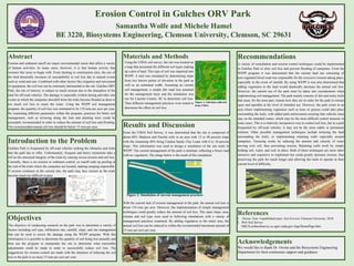
with no vegetation. The image below is the result of this simulation.
Figure 2: Simulation of current management practices
With the current lack of erosion management in the park, the annual soil loss is
about 110 tons per acre. However, the implementation of simple management
techniques could greatly reduce the amount of soil loss. The same slope, area,
climate and soil type were used in following simulations with a variety of
management practices examined. By adding vegetation to the entire area, the
annual soil loss can be reduced to within the recommended maximum amount of
15 tons per acre per year.
Erosion Control in Gulches ORV Park
Samantha Wolfe and Michele Hamel
BE 3220, Biosystems Engineering, Clemson University, Clemson, SC 29631
Recommendations
A variety of remediation and erosion control techniques could be implemented
in Gulches Park to slow soil loss and prevent flooding of campsites. From the
WEPP program it was determined that the current land use consisting of
non-vegetated forest road was responsible for the excessive erosion taking place,
especially in the event of rainfall. By using WEPP it was also determined that
adding vegetation to the land would drastically decrease the annual soil loss.
However, the current use of the park must be taken into consideration when
implementing soil management. The park mainly consists of dirt and rocky trails
that must, for the most part, remain how they are in order for the park to remain
open and operable at the level of intended use. However, the park exists in an
area where implementing vegetation such as trees or grasses could take place
surrounding the trails, with added park enforcement ensuring that vehicles must
stay on the intended routes, which may be the most difficult control measure in
some cases. This is a relatively inexpensive way to control soil loss, but in a park
frequented by off-road vehicles, it may not be the most stable or permanent
solution. Other possible management techniques include terracing the land
surrounding the trails, or implementing retaining walls especially around
campsites. Terracing works by reducing the amount and velocity of water
moving over soil, thus preventing erosion. Retaining walls work by simply
holding soil, water, and rock in place. Both of these techniques are more labor
intensive and expensive to implement but could greatly decrease erosion, thus
preserving the park for much longer and allowing the trails to operate at their
current level of difficulty.
References
1. Owino, Tom. Unpublished notes: Soil Erosion; Clemson University, 2018.
2. Web Soil Survey.
NRCS,websoilsurvey.sc.egov.usda.gov/App/HomePage.htm.
Acknowledgements
We would like to thank Dr. Owino and the Biosystems Engineering
Department for their continuous support and guidance
Introduction to the Problem
Gulches Park is frequented by off-road vehicles seeking the obstacles and trials
that the park has to offer. Unfortunately, frequent and heavy rainstorms take a
toll on the structural integrity of the trials by causing severe erosion and soil loss.
Currently, there is no erosion or sediment control, so runoff ends up pooling at
the end of the trials where the campsites are located, making camping impossible.
If erosion continues at the current rate, the park may face closure as the trials
become much too difficult to pass.
Objectives
The objective of conducting research on the park was to determine a variety of
factors including soil type, infiltration rate, rainfall, slope, and site management
that can be used to assess the damage using the WEPP program. With this
information it is possible to determine the quantity of soil being lost annually and
then use the program to manipulate the site to determine what reasonable
adjustments could be made in order to successfully reduce soil loss. The
suggestions for erosion control are made with the intention of reducing the soil
loss in the park to no more 15 tons per acre per year.
Abstract
Erosion and sediment runoff are major environmental issues that affect a variety
of human activities. In many cases, however, it is that human activity that
worsens this issue to begin with. From farming to construction sites, the use of
the land drastically increases its susceptibility to soil loss due to natural events
such as wind and rain. Combined with other factors like irrigation and movement
of equipment, the soil loss can be extremely detrimental to the site. Gulches ORV
Park, the site of interest, is subject to much erosion due to the disruption of the
land for off-road vehicles. The damage is especially evident during and after rain
events in which the campsites downhill from the trials become flooded as there is
too much soil loss to retain the water. Using the WEPP soil management
program, the quantity of soil loss was estimated to be 110 tons per acre per year.
By examining different parameters within the program, practices for better soil
management, such as terracing along the trail and planting trees could be
accurately recommended in order to reduce the amount of soil loss and flooding.
The recommended annual soil loss should be below 15 tons per acre.
Materials and Methods
Using the USDA soil survey, the site was located on
a map that presented the different soil types making
up a plot of land. This type of soil was imported into
WEPP. A trail was simulated by determining slope
from two known points of elevation in the park as
well as an estimated width. Assuming no current
soil management, a simple dirt road was assumed
for the management layer and the simulation was
run for Laurens County, SC to determine soil loss.
Then different management practices were tested to
determine the effect on soil loss.
Figure 1: Soil data collected
from USDA
Source: http://www.gulchesorvpark.com/