BE-GOOD Challenges - factsheet 2017-06
•
1 like•104 views

BE-GOOD is a pioneering project aiming to unlock, re-use and extract value from Public Sector Information (PSI) to develop innovative data-driven services in the area of infrastructure & environment. BE-GOOD’s main outputs: 10 novel commercial PSI-based services prototyped operationally, with the aim to commercialise 5. Examples: applications, visualisations, software, algorithms for traffic management, air and water quality monitoring, infrastructure maintenance planning. http://www.nweurope.eu/begood

Recommended
Recommended
More Related Content
What's hot
What's hot (20)
Similar to BE-GOOD Challenges - factsheet 2017-06
Similar to BE-GOOD Challenges - factsheet 2017-06 (20)
More from Slim Turki, Dr.
More from Slim Turki, Dr. (17)
Recently uploaded
Recently uploaded (20)
BE-GOOD Challenges - factsheet 2017-06
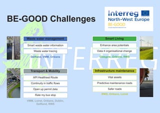
- 1. BE-GOOD Challenges Smart waste water information Enhance area potentials API Healthiest Route Vital assets Continuity in traffic flows Predictive maintenance roads Open up permit data Safer roads Waste water tracing Data 4 organisational change Rate my bus stop Delfland, VMM, Orléans Glasgow, Orléans, RWS VMM, Loiret, Orléans, Dublin, Delfland, RWS RWS, Orléans, Loiret Waste water management Smart Living Transport & Mobility Infrastructure maintenance
- 2. 2016 2017 2018 2019 2020 NL BE FR IE UK LU Summary Budget Map Partners Countries Timeline Contact details BE-GOOD is a pioneering project aiming to unlock, re-use and extract value from Public Sector Information (PSI) to develop innovative data-driven services in the area of infrastructure & environment. BE-GOOD’s main outputs: 10 novel commercial PSI-based services prototyped operationally, with the aim to commercialise 5. Examples: applications, visualisations, software, algorithms for traffic management, air and water quality monitoring, infrastructure maintenance planning. Total budget: € 6.45 m EU funding: € 3.87 m Lead partner organisation: Ministerie van Infrastructuur & Milieu - Rijkswaterstaat Partner organisations: * Vlaamse Milieumaatschappij * Orléans Métropole * Départemental du Loiret * Comhairle Cathrach Bhaile Átha Cliath (Dublin City Council) * Glasgow City Council * Luxembourg Institute of Science and Technology *Hoogheemraadschap van Delfland Natalie Oonk - Rijkswaterstaat E: natalie.oonk@rws.nl Key Information
- 3. Q4 Q1 Q2 Q3 Q4 EvaluationFirst Group Second Group Data 4 Oganisational Change Safer Roads Enhance Area Potentials Rate my Bus Stop API Healthiest Route Continuity in Traffic Flow Smart Waste Water Information Vital Assests Waste Water Tracing Predictive Maintenance of Roads Open up Permit Data WP T2 group 1 & group 2
- 4. 5- Transnational Twinning BE-GOOD partners or members of their organisations who envisage a similar use or alternative uses for such a system of enforcement, monitoring and reporting. 8- Targeted Public Authority Staff, Members of the Public and the Beneficiaries are citizens of the city who will benefit from an improved and safer environment. Open Up Permit Data 2- Aim 7- Planning and realisation 4- Need 3- Context 1- Issue Q4 2016: Challenge Description; Market Consultation; API sign off Q1 2017: Procurement process Q2 - Q3 2017: Development Open data platform is required to open up initial permit data to enable the development of an APP. Provide the local police with an APP that can be used to confirm if a vehicle that is in the category has a valid permit for enforcement. HGVs are not permitted to enter the restricted area without a permit and the APP will assist with enforcement during the time of operation. Develop an application that will assist An Garda Siochána when enforcing the HGV management strategy and allow members of the public to verify and report on violations, empowering the citizen to assist in non compliance of the HGV strategy and enhance the environment and safety of the city. 6- Necessary data Currently there is no formal process for An Garda Siochána (the enforcing authority) or for members of the public to verify or report heavy good vehicles (GHV) infringements.
- 5. 1- Issue Currently there is no way for Public Transport (PT) Users to engage with transport providers that enables users to provide feedback on the performance of their stop while also receiving information on the optimal stop choice in their areas. 8- Targeted Public 5- Transnational Twinning BE-GOOD partners or members of their organisations who see a use for such a system of reporting. Public Transport Users & Public Transport Providers. Rate my Bus Stop 2- Aim 6- Necessary data 7- Planning and realisation 4- Need 3- Context Q3 2016: Start Date Q2 2017: Procurement The data to enable development is open and available through an API. Specific performance analysis of PT stops and inform users of their stop performance. Enhance PT and aim to increase modal split. The system will empower PT users during their journey by offering them a means by which they can provide feedback on the quality of service they are receiving. This will enable PT service providers to improve the quality of service. Provide a system to retreive and analyse stop specific information where information on the level of service provided by the user can be received via an APP. Develop a system to engage the public that measures and improves PT performance while offering the customer an alternative selection of stops through the analysis provided.
- 6. Existing data endpoint are geared to users with sufficient expertise to interpret the information. Provide a quality assured, scientifically sound data endpoint which can be used by any existing routing application to identify the healthiest route alternative. 8- Targeted Public 5- Transnational Twinning Département du Loiret and all consortium members who plan to use hackathons to refine the idea. API Healthiest Route 2- Aim 7- Planning and realisation 4- Need 3- Context 1- Issue The air quality on the routes you take is poor and this is not visible. Pedestrians, cyclists, commuters, planners, the public in general. Make impact of poor air quality more tangible to non- expert users. Q1-2 2017: develop data exchange model Q1 2019: API Q1 2020: demo implementation in a routing app 6- Necessary data
- 7. Continuity in Traffic Flow 2- Aim 6- Necessary data 7- Planning and realisation 4- Need 3- Context Q1 2017: Test of real-time data with WAZE Q2 2017: Release of Open Data Q2 2017: Procurement process Q 3 2017: Procured Q1 2018: Procurement for development Provide reliable information of traffic flow disturbance to road users “near real time”. Speed improvement of road interventions by combining crowdsourcing and public data of local governments. A vulnerable area with historical flood events, with important logistic poles and significant daily traffic flow. In May/June 2016: large flood in the Loiret and Orléans Metropole. Road users, public administration, private companies. 8- Targeted Public 5- Transnational Twinning Dublin City Council, Rijkswaterstaat 1- Issue All traffic impacts : roadworks, congestions, floods, snow
- 8. 5- Transnational Twinning Département du Loiret, Orléans Métropole, Glasgow City Council and Luxembourg Institute of Science and Technology. 8- Targeted Public Road managers, contractors, insurance companies, knowledge institutes. Predictive Maintenance of Roads 2- Aim 6- Necessary data 7- Planning and realisation 4- Need 3- Context 1- Issue Obtaining data, cooperation and collaboration with parties that: - Are able to provide data - Have expertise and thinking power for innovative data analyses. Deploying innovative procurement to facilitate SME’s to be involved. Q2-Q3 2017: Design of challenge combined with safer roads 2017-2018: Analyses, refinements, prototype development 2018-2019: Prototype evolution 2019-2020: Product formulation and dissemination to business Pavement conditions, construction, maintenance history, temperature and dampness history, geodesy and traffic engineering data, load history and traffic intensity, road use, number of accidents. Save money and enhance road safety by changing from time programmed to condition based maintenance of roads. Road maintenance is very important for traffic throughput and safety. Traditionally maintenance is planned yearly, thus often untimely, making repairs more expensive, jeopardizing traffic safety and wasting public money. Performing analyses on shared and open data, to enable condition based maintenance of asphalt concrete road pavements and to obtain safer roads.
- 9. 8- Targeted Public 5- Transnational Twinning Vlaamse Milieumaatschappij Smart Waste Water Information Management (SWWIM) 2- Aim 6- Necessary data 7- Planning and realisation 4- Need 3- Context 1- Issue A lot of data is available but not used. Moreover, the data is separated among different parties and databases. Q2 2017: Project scope and requirements Q3 2017: Evaluation datasets Q1 2018: Procurement/selection Q3 2018: Implementation and commissioning - (Waste) Water Sector - Public Sector - Consultancy companies - ICT companies - Infrastructure Geo Data - Data from sewers, pumping stations, waste water treatment plants - Meteo data - Maintainance data Sharing data, improving knowledge and understanding. Better decisions on investments, maintainance and operations. 12 Municipalities 2 Drinking Water Companies 1 Regional Water Authority Advancing the existing data by combining separate datasources. Increasing control, oversight and cost saving in the urban (waste) water cycle.
- 10. Trace the route of the waste water: - within the sewer and water network - upstream and downstream - obtain a view on POI on the route 1- Issue Minimize data gathering process and making data analysis more user friendly to allow a faster and broader view on the situation, source and destination. 8- Targeted Public 5- Transnational Twinning Hoogheemraadschap van Delfland Governmental and environmental organizations, sewer system managers, fire brigade. Waste Water Tracing 2- Aim 6- Necessary data 7- Planning and realisation 4- Need 3- Context Q1 - Q3 2017: Collection of data Q2 - Q4 2017: Harmonisation Data Q3 2017: Procurement process/ development start Q1 2018: Start prototyping Sewer data will be updated, Hydrography data harmonised to INSPIRE data specs. Other data (POIs, precipitation, protected areas) are available Provide incident managers and environmental actors with more information by combining existing data to improve the management of the sewer network system. Better understanding of source and destination of waste water and pollutants that can travel through the waste water system.
- 11. 1- Issue Ownership of sensordata, cyber security and intellectual property of algorithms. 8- Targeted Public 5- Transnational Twinning Hoogheemraadschap van Delfland, Vlaamse Milieumaatschappij and Département du Loiret Maintenance contractors, industry and IT companies. Vital Assets 2- Aim 7- Planning and realisation 4- Need 3- Context Q2 2017: Start date Optimizing the maintenance of infrastructure and reducing costs by using sensor data, open data and data analyticts. The ways and waterways are of great importance for the Dutch economy. But, the majority of Dutch infrastructure is rather old with high costs of failure due to untimely maintenance. Keeping our infrastructure healthy by using data and data analytics together with our maintenance partners. 6- Necessary data Data of (energy) sensors, SCADA-data and open data such as weather data.
- 12. 1- Issue Achieving more effective and more efficient services 8- Targeted Public 5- Transnational Twinning Orléans Metropole and Rijkswaterstaat - Small/Medium Enterprises: challenge fund environment - Citizens – service users Data 4 Organisational Change 2- Aim 6- Necessary data 7- Planning and realisation 4- Need 3- Context Q3 2017: Start Challenge Q1 2018: Developed intervention Q3 2018: Managed outcomes - Understand the context and how it changes - Link with operational data to show the effect of existing services - Generate new services to drive improvement - Evaluate existing services to identify suitable areas of activity - Identify opportunities for service improvement through use of data - Link with existing service providers to improve services - Make better match between user need and service provision - Reduce duplication - Develop predictive analysis Use data to provide better services at a reduced cost
- 13. 5- Transnational Twinning Rijkswaterstaat 8- Targeted Public - Insurance companies - Users - Road managers Safer Roads with less Money 2- Aim 4- Need 3- Context 1- Issue Obtain free and anonymised data from insurers to be able to use and publish them. Build a robust predictive model, useful for decision-making and intervention 2017: setting up the partnership 2018: operational predictive model (prototype) - Number of accidents and location - Weather conditions - Roads (layout, coatings, works) Obtain anonymized data from insured persons who have reported a vehicle disaster. Cross the data to identify areas with a high likelihood of accidents Little awareness of all accidents occurring on the roads. A better knowledge of the places, periods and causes of material accidents (the most frequent) could improve infrastructure or information given to users Reducing probability of accidents by influencing infrastructure and user information via an IT solution. Reduce management and maintenance costs by targeting and better planning interventions 6- Necessary data 7- Planning and realisation
- 14. Enhance the Value of the Area Potentials 2- Aim 6- Necessary data 7- Planning and realisation 4- Need 3- Context 1- Issue Development of innovative digital tools to enhance the area values. Q3 2017: Data will be available Q4 2017: Procurement process Q1 2018: Procured Area promotion and marketing. Popularization of biodiversity, environmental awareness of the general public. Involvement of public companies to make commercial use of the area. Rijkswaterstaat Citizens (families, business tourists, schools), public administration, private companies. 8- Targeted Public 5- Transnational Twinning An area listed as an UNESCO World Heritage. The Loire is the last wild river of Europe. An exceptional natural and historical heritage.