(INDIRA) Call Girl Katra Call Now 8617697112 Katra Escorts 24x7
Wx forcasting and Reporting for mariners.pdf
1.
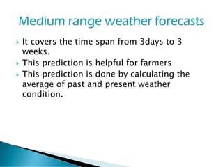
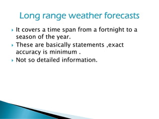
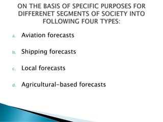
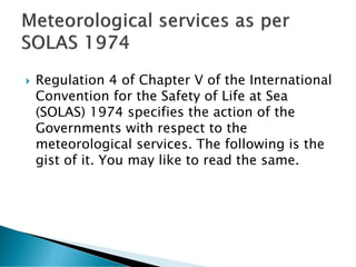
2. The World Meteorological Organization (WMO)
is a specialized agency of the United Nations.
It is the UN system's authoritative voice on the
state and behavior of the Earth's atmosphere,
its interaction with the oceans, the climate it
produces and the resulting distribution of
water resources.
3. WMO has a membership of 191 Member States and
Territories (on 1 January 2013). It originated from the
International Meteorological Organization (IMO),
which was founded in 1873.
Established in 1950, WMO became the specialized
agency of the United Nations in 1951 for meteorology
(weather and climate), operational hydrology and
related geophysical sciences.
WMO facilitates the free and unrestricted exchange of
data and information, products and services in real-
or near-real time on matters relating to safety and
security of society, economic welfare and the
protection of the environment.
It contributes to policy formulation in these areas at
national and international levels.
4. WMO promotes cooperation in the establishment
of networks for making meteorological,
climatological, hydrological and geophysical
observations, as well as the exchange,
processing and standardization of related data,
and assists technology transfer, training and
research.
It also fosters collaboration between the National
Meteorological and Hydrological Services of its
Members and furthers the application of
meteorology to public weather services,
agriculture, aviation, shipping, the environment,
water issues and the mitigation of the impacts of
natural disasters.
5. The weather forecasting has now become a science
and it is performed by adopting the following
procedures (steps) :
1. recording of weather data (temperature,
pressure, wind speed and direction, cloud
forms, humidity and precipitation, visibility,
storms etc.)
2. collection of weather data from weather
recording (observations centers) stations
scattered world over including both land and
ocean surfaces
3.transmission of weather data collected form
major weather stations to sub centers .
6. 4. Compilation of weather data.
5. Plotting of weather data on maps and daily
weather records, synoptic charts etc.
6.Analysis of weather charts ansd maps with
the help of electronic computers etc.
7. Final forecasting of weather and numerical
modeling .
7. RADIOSONDES
It is an instrument that is
carried aloft by a
balloon to send back
information on
atmospheric
temperature, pressure
and humidity by means
a small radio
transmitter
8.
9. The most advanced technology is weather
satellite of different kinds attached with
different types of sensors for specific purposes
and having varying orbital paths around the
earth.
The first weather satellite , named TIROS-I was
launched in 1960
The sensors which are attached with satellites
send back to the images of clouds to earth's
centre .
10. Geosynchronous Satellites
➢ Same rate of movement around the earth as that of
the rotational speed of the earth.
➢ These are fixed at the altitude of 35,786 kilometers
from the sea level
➢ These are called high altitude satellites.
➢ Provide scanned pictures of larger areas.
➢ These having imaging sensors instruments that
provides thermal variations of the atmosphere,
moisture etc.
Example: ATS series and GOES series weather
satellites.
11.
12. These are positioned at the altitude ranging
between 800 to 1500 kilometers
These are also known as low altitude satellites
These having sounding sensors naming
ADVANCED VERY HIGH RESOLUTION
RADIOMETER (AVHRR)
Example: TIROS and NOAA
13.
14. These are useful tools to obtain detailed
information about clouds and storms mainly
cyclones , tornadoes, hurricanes.
15. On the basis of duration of the validity of
forecasts into three types as follows :
1.Short range weather forecasts
2.Medium range weather forecasts
3. Long range weather forecasts
16. Most useful predictions of weather wherein
forecasts valid from few hours to48 hours
and sometime 72 hours
Based on maps weather charts , satellite
images
Determines change of atmospheric weather
of a specific location
Persistent method & continuity methods are
applied .
Helps in Shipping, Aviation and other
transportation services and fishing Traffic. .
17. It covers the time span from 3days to 3
weeks.
This prediction is helpful for farmers
This prediction is done by calculating the
average of past and present weather
condition.
18. It covers a time span from a fortnight to a
season of the year.
These are basically statements ,exact
accuracy is minimum .
Not so detailed information.
20. Regulation 4 of Chapter V of the International
Convention for the Safety of Life at Sea
(SOLAS) 1974 specifies the action of the
Governments with respect to the
meteorological services. The following is the
gist of it. You may like to read the same.
21. V / 4 specifies the following duties for the
Administrators with respect to the weather services.
Encourage collection of meteorological data by ships
at sea.
Arrange for their examination dissemination and
exchange in a suitable manner.
Providing for use of instruments of high accuracy and
checking the same.
Arrange for the following services:
Warn ships of gales, storms and tropical revolving
storms by issue of rad, warnings and local signals.
Issue of daily weather bulletins for shipping,
containing data on existing weather, waves, ice and
forecast. The bulletins should contain information so
that the ship can prepare a weather chart.
22. Transmission of facsimile weather charts,
Provide the necessary weather information
publication to facilitate weather observations.
Provide daily weather charts for departing ships,
Provide tested equipment to selected ships such
as barometer, barograph. psychrometer and a
suitable apparatus for measuring sea temp.
Encourage selected ships at sea to take and
report observations at least four times in a day.
Encourage other ships to take observations in a
modified form in areas where shipping is sparse
and / or the weather is unsettled.
23. Provide facilities to send such report by radio
with no cast to the ships
Instruct ships to send their messages through
ocean weather ships or other ships when it is
not possible to send them by radio.
Instruct masters to report in accordance with
the international radio regulations (with a
prefix TTT) when:
wind speed exceeds 50 knots
the ships meets dangerous ice,
the ship meets dangerous derelicts
24. Wx Reporting system
As recommended by the World Meteorological
Organisation (WMO), each government
recruits a number of merchant ships called
the Voluntary Observing Fleet (VOF).
25. The Indian VOF consists of Indian ships and such
foreign vessels that frequently and regularly call at
Indian ports and hence treat an Indian port as their
homeport.
Each vessel of the VOF makes weather observations at
fixed Greenwich Mean Times (called synoptic hours),
codes these observations and transmits them by W/T,
TOR (Telex over radio), or by Satcom (Satellite
communication), as soon as possible, to the area
headquarters or to the nearest coast radio station. The
coast radio stations transmit these coded messages by
land telegraph or teleprinter to the area headquarters,
on a priority basis. The ship does not incur any expense
for this transmission. The respective meteorological
departments and the administration bear these
charges. The India Meteorological Department provides
all necessary equipment, publications and stationery
used by the Indian VOF.
26. The weather codes have been devised in such
a manner that the messages can easily be
electronically processed and stored to enable
better forecasts to be made.
The area headquarters gathers all the reports
of that area and makes weather forecasts,
which are transmitted to ships of that area, as
W/T weather bulletins , through selected
coast stations, at fixed times.
27. Under normal conditions of weather, the hours of
observation, called synoptic hours, are 00, 06, 12 and 18
GMT. In cases where there is disturbed weather, additional
synoptic hours are 03, 09, 15 and 21 GMT.
The coded messages should be transmitted as soon as
possible. In case of any genuine delays, a message may be
transmitted up to four hours after the time of observation.
In the case of ships. the time of observation is always the
GMT when the barometer reading is taken.
In case any unusual but urgent weather phenomena are
seen, a special message in code or in plain language may
be sent out at any time. Such messages, if sent out in plain
language, carry the prefix TTT. Examples of such
messages are given later in this module.
28. Each ship of the VOF is given a meteorological or
weather logbook. All weather observations at
synoptic hours and any special message must be
recorded neatly and legibly in the weather logbook,
whether they were transmitted by W/T or not.
When each logbook is completed, it is to be returned
to the India Meteorological Department. The W/T
messages received from the vessel will be compared
with the logbook to eliminate errors during
transmission. The log- book may contain additional
remarks that were not transmitted in the coded
messages. The data from logbooks are fed into
computers for future use.
29. In accordance with the recommendation of the WMO, vessels of the VOF
are divided into three categories:
Selected ship: A mobile ship which is equipped with sufficient certified
meteorological instruments for making observations and which
transmits the required observations in the full code consisting of
eighteen to twenty one groups.
Supplementary ship: A mobile ship which is equipped with a limited
number of certified meteorological instruments for making observations
and which transmits the observations in the abbreviated form of the
code consisting of twelve or more groups.
Auxiliary ship: A mobile ship normally not provided with certified
meteorological instruments which transmits weather reports in disturbed
weather or under a special request, in the reduced form of the code
consisting of eleven or more groups or in plain language.
Ships not recruited in any of the categories are requested to transmit
weather reports on their own initiative in case of disturbed weather.
30. The following equipment is manufactured and
supplied, free of charge, by the India Meteorological
Department:-
Navigation
Selected ship:
Kew-pattern mercury barometer with Gold Slide
Weekly barograph
Whirling psychrometer
Sea-thermometer
Marine bucket
32. The India Meteorological Department, supplies the following
publications to selected and supplementary ships, free of charge:
Monthly meteorological charts of the Indian Ocean
Indian Ocean Currents.
Marine Observer’s Handbook.
International Cloud Atlas.
Ship’s Weather Code.
Weather Services to Shipping, Fishing Vessels and Marine
Interests.
Code of Storm Warning Signals.
Handbook of Cyclonic Storms in the Bay of Bengal.
Winds, Weather and Currents Coasts of India.
State of Sea Card.