Vardar
•Download as PPT, PDF•
0 likes•3,418 views

The Vardar is the longest river in the Republic of Macedonia, rising in the mountains near Gostivar and flowing 388 km southeast through Skopje and into Greece before emptying into the Aegean Sea near Thessaloniki. It drains over 25,000 square kilometers and has been an important geographic feature, with the Vardar Valley forming a key corridor through the Balkan Peninsula. Folk songs celebrate the river and its surrounding nature.

Recommended
More Related Content
What's hot
Similar to Vardar
Similar to Vardar (20)
More from Nate Nate
Recently uploaded
Recently uploaded (20)
Vardar
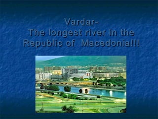
- 1. Vardar- The longest river in the Republic of Macedonia!!!
- 2. Geographical facts The Vardar or Axios is the longest and major river in the Republic of Macedonia and also a major river of Greece. It is 388 km long, and drains an area of around 25,000 km2 .The maximum depth of river is 4 m. The river rises at Vrutok(montain Sar Planina), a few kilometers north of Gostivar in the Republic of Macedonia. It flowing northeast then southeast in a fertile valley, past Skopje , through Greece to the Aegean Sea near Thessaloníki . The Vardar valley forms part of the principal corridor of the Balkan Peninsula .
- 3. The Vardar basin includes two-thirds of the territory of the Republic of Macedonia. The area is sometimes called "Vardar Macedonia“. The river is surrounded by mountains anywhere. The river is depicted on the coat of arms of Skopje, which in turn is incorporated in the city's flag.
- 4. The Vardar’s tributaries and cities that it goes through Vardar has really composite river valley for lining gorges and valleys one after the other along its flow. The river rises in Vrutok, a few miles southwest of Gostivar in the northwestern part of Macedonia. Continues to flow through the valley town of Gostivar and nest where several tributaries flow: Lakavica, Mazdracha, Pena, Bistrica brandy. Then through Dervenskata ravine entangled in Skopje where the valley receives water from Lepenec, fever, and Pchinja Markova River and passes through Skopje. Passing through the gorge where Taorskata flows Kadino River Vardar Veles getting into the small valley and passes through Veles. There are flowing rivers and Topolka Babuna. After getting through the gorge in Veles Tikvesh flowing valley where two of its largest tributaries of Black River Bregalnica right and the left side. Demir getting into the famous gorge, and through her in- Valandovo Gevgelija valley where it crosses the Greek border, passing through the gorge Gypsy, and flowing through the Thessaloniki area flows into the Aegean Sea in the west of Thessaloniki in the Aegean Macedonia.
- 5. Etymology Known story is that the river got its name in honor of the Romanprefect of Skupi, named Vardar Sklir and who reg ulate the flow of the river and thereby saved the city from flooding. Vardar name is similar to the names of other rivers flowing into Central Azija - Syr Darja, Amu Darja and Chebdar. Darja word isPersian and means river, sea or ocean. Hidronimot age probably originated from Gothic word "V ordol",which is given to the river when the Goths were in this region.Vardar waters originating from the same name Thracian wordmeaning "black water".
- 6. Folk songs about Vardar There are many folk songs that speak of our largest and also the longest river Vardar.
- 7. Близ реката Вардар (Near the river Vardar ) Близ реката Вардар има планина, При неја полјана, широка она, А в таја полјана кичеста трава, Да продумат готова с живи слова. Тамо, о мила, во шума, во гора, При ветер прохладен, во глабока зора, Радостно славеј сја разбудват от сон И слатко и мило песни пеит он. И тамо на утро ветер веит чист И кротко нишат на дрвета лист, Там радостбо пасит елен виторог, Там радостно играт кошут брзоног. Tам распуснал си гранки јавор висок, Он пâлноцветен, гâстолист и широк, И тој јавор зготвил нам шатор сенлив. Под него ја седам нажален, сâлзлив.
- 8. Made by : Hristina Trpcevska (2nd-3th slides) Darko Boskovski (4-th slide) Angela Ivanova (5-th slide) Stefanija Bozinovska (6th-7th slides) VII-A.odd