Living Dhaka is a social technology experiment that uses "tiger tags" - paper with QR codes - to track activity in Dhaka, Bangladesh. Volunteers carry smartphones to scan tags, collecting data on location, happiness, and transportation mode. This data is sent to the cloud and aggregated to measure pedestrian flows, bus ridership, and more. The goal is to better understand urban mobility in Dhaka and identify experiments to improve non-motorized travel.
Future of cities and universities 20120619 v2ISSIP
The document discusses IBM's University Programs worldwide initiative called IBM UPward, which aims to accelerate regional development through partnerships between IBM, universities, and cities. It provides an overview of IBM's work on smarter cities projects, how analytics and cloud computing are enabling new insights, and how service science frameworks can help measure societal outcomes like quality of life, innovativeness, and sustainability.
Kyoorius Design Magazine 25 – A Post-event Essay on Z-Axis 2014Anusha Narayanan
Architecture is a discipline, which lies in this grey zone between design and science, art and utility, physical and cultural i.e. tangible and intangible. Of how much consequence is it as a practice to the urban fabric? After the Z-Axis Conference of 2015, this was a post-event essay I wrote for Kyoorius Magazine.
The document provides steps for making a bus map for a city, based on the experience of creating the first bus map of Dhaka, Bangladesh. It outlines 6 steps: 1) Recruit volunteers who ride the buses to collect data; 2) Build on any existing information; 3) Determine the appropriate format(s) for sharing the information; 4) Select data collection tools like smartphones; 5) Have volunteers collect route and schedule data over 1-2 weeks; and 6) Design, publish and iterate the map based on analyzing and organizing the collected data. The goal is to provide clear bus information to riders in an appropriate format for the local context.
The Forces that Will Shape the Future of Harvard SquareAlbert Ching
1) Over the past 50 years, retail in Harvard Square has evolved from catering to everyday students to higher-end boutique retail due to economic forces.
2) While the physical form of Harvard Square has remained largely the same, retail uses have changed dramatically with many independent shops replaced by banks, cell phone stores, and national chains.
3) However, some argue that meaningful retail experiences arose from intentional efforts by business and community stakeholders to blend Harvard Square with the surrounding university environment.
The digital city program proposes a system to create new jobs by addressing the digital divide and lack of technical skills through an integrated online platform. It would provide intermediate and advanced technical courses, create local projects sponsored by brands that provide internships, and leverage free online tools and video help to train underemployed and unemployed individuals in skills needed for freelance work. The system aims to make technology accessible and build technical confidence to simultaneously address workforce development and generate ongoing funding through the platform, projects, and various revenue streams.
The document discusses governance and policy issues related to managing the complex urban region of Greater Manchester. It outlines several policy strands around regeneration, local government modernization, and performance management. It also discusses the role of localities during economic recessions and mechanisms that have been used in Manchester to coordinate governance across multiple local authorities.
The Urban Launchpad: Initial Design BriefAlbert Ching
The document discusses plans to use mobile sensors and volunteers to measure the impact of city experiments in Dhaka, Bangladesh. Zia, the mayor of Dhaka, wants to reduce traffic congestion but needs better data to evaluate experiments. The Living Dhaka initiative would recruit volunteers to register as users and scan QR codes using a mobile app to anonymously track transportation mode. The data would help analyze experiments like closing roads or promoting alternatives to cars. It outlines requirements, a timeline, and prototypes for testing the mobile apps and backend systems with the goal of launching in Dhaka in January.
Paromita Roy is an architect and urban designer currently serving as Deputy Director at UTTIPEC in Delhi. She has over 15 years of experience working on projects in Asia, Africa, Europe, Russia, and the US. Some of her key responsibilities at UTTIPEC include leading the development of Transit Oriented Development policies and guidelines for Delhi and overseeing the implementation of various urban design projects aimed at improving road safety and public transportation.
Design Your Dhaka - Launching January 2012Albert Ching
The document discusses a design challenge initiative called "Design Your Dhaka Like You Give a Damn" which aims to improve transportation alternatives in Dhaka, Bangladesh over 3 months. It notes that cities don't innovate or share ideas enough. The initiative will identify challenges in Dhaka, build a local and global design team to generate ideas, and rapidly prototype solutions. The goal is to help Dhaka become a more innovative city and share successful experiments with other cities.
This document summarizes a study on analyzing walkability for the Islamabad Metro bus project and forecasting metro bus user numbers for 2025 and 2035. The study aims to measure and analyze low and high walkability indexes along the 23km metro bus route connecting Rawalpindi and Islamabad. Tools like Google Earth, ArcGIS, and a GIS walkability index tool were used to analyze walkability. The study also aims to analyze population density changes around metro bus stations and predict urban expansion impacts for future analysis periods ending in 2035.
- Over 1 year of experience as a Transport Planner in India, with expertise in transport planning software like VISSIM and VISUM as well as AutoCAD and Microsoft Office.
- Obtained a Master's degree in Transportation Planning and Engineering with a 2.2 grade and Bachelor's degree in Civil Engineering with a 2.1 grade.
- Project experience includes traffic studies, evaluating transport infrastructure proposals, and designing bus priority corridors using traffic simulation software.
- Interests include attending transport conferences and actively participating in university transport study groups.
This presentation forecasts how urban planning and technology is shaping our cities through smart city initiatives. Ultimate objective is to make people happy and provide impactful experiences for people living in cities and solving cities challenges. Technology is only an enabler but people come first. These initiatives should be driven by outcomes and what cities want to achieve and become.
TNO's Smart Cities initiative takes an integrated, multidisciplinary approach to developing smart city solutions in collaboration with citizens, authorities, companies and research centers. The goal is to foster innovation and develop attractive, competitive and sustainable cities. TNO works on themes like smart mobility, health, energy and environment. It develops tools to analyze the effects of infrastructure projects on factors like traffic, emissions and noise. TNO also contributes to national and EU smart cities activities and supports several Dutch living labs focused on areas like sensors, mobility and powermatching technologies.
Review Paper on Intelligent Traffic Control system using Computer Vision for ...JANAK TRIVEDI
This document reviews research on intelligent traffic control systems for smart cities using computer vision. It discusses various algorithms that have been proposed for tasks like vehicle tracking, incident detection, and parking availability. It also describes some smart phone applications and projects from companies that aim to improve transportation management systems. While progress has been made, the document notes that challenges remain like dealing with different lighting conditions and weather events. It concludes that more work is still needed to better implement real-time traffic management in smart cities.
Smart cities of the future will utilize sensors, networks, and data analysis to monitor resources and services in real-time, helping with short-term decision making and anticipating future needs. Private and public sectors can then adapt cities towards economic, social, or environmental goals. Early examples include IBM's work in Zhenjiang, China using data to manage transportation and reduce traffic and emissions. The future city will be smarter, greener, and more connected through innovations like those seen in Songdo, South Korea which automatically manages waste and uses sensors to provide real-time transit updates. Cities will also undergo "greenification" through renewable energy, eco-friendly design, and reimagining transportation infrastructure to be more sustainable.
Smart City & Smart Citizen
looking at the city and citizen with perspective of design thinking and find out issues and solutions; many alternatives.
You can get more info at
http://www.designconvivial.com/
Virtual planning tools can help speed up progress, reduce risk, improve collaboration and communication, and demonstrate rigor in project planning and design. Testimonials from various project managers and directors highlight specific benefits experienced:
- Interactive 3D presentations played an essential role in designing, integrating and communicating projects to clients throughout the process.
- The virtual plan reduced disputes and meetings, allowing stakeholders to understand projects and gain support more quickly.
- Complex solutions could be effectively communicated to communities and stakeholders in an innovative way.
- Working within the virtual context facilitates good urban planning and design.
Crowdsourcing and citizen engagement for people-centric smart citiesElena Simperl
This document discusses how crowdsourcing and citizen science can be used to improve smart cities through collective intelligence. It describes how crowdsourcing involves solving problems through open crowds, using both paid microtasks and unpaid volunteering. Citizen science involves scientific research conducted by amateur scientists. The document outlines examples like using crowdsourcing to audit urban areas through a virtual street view tool. It emphasizes that citizen engagement projects must consider people's diverse motivations for participating and align incentives appropriately to encourage sustained involvement. Assessments of data quality and understanding participant behaviors are also important.
The document describes the two phases of the Saarthi project, which aims to develop an electric vehicle to provide transportation for citizens in Jabalpur, India. Phase 1 involved designing and developing a prototype vehicle. Phase 2 saw a partnership form between the designer and Freedomwheels, an organization that provides mobility solutions for people with disabilities, to further develop the prototype into a manufacturable product. The vehicle was designed through user research, ideation, prototyping and testing to create an affordable and accessible mode of transportation.
This document outlines a methodology for implementing transit oriented development (TOD) in Delhi, India. It discusses the context and need for TOD to address issues like urban sprawl, resource consumption, and air quality. A 5-step procedure is proposed: 1) establish a vision and goals, 2) coordinate land use and transportation planning, 3) develop public participation and TOD typologies, 4) create development codes, and 5) implement and monitor projects. Key aspects include integrated modeling of land use and transportation alternatives, establishing mixed-use zones within 5 minutes of transit, and using form-based codes to control the public realm. Test sites are suggested to pilot the approach.
- City development authorities and citizen groups in India are working to make roads more friendly for cyclists as a way to encourage environmentally friendly transportation.
- However, cycling has become an unpleasant experience for many due to issues like lack of dedicated cycling lanes and encroachment of bike paths by vehicles and vendors.
- Several cities have begun efforts to address this by creating more cycling infrastructure like lanes and improving urban planning, but challenges remain around social attitudes and prioritization of motor vehicles on roads.
This document contains testimonials from various clients and professionals praising the services provided by Urban Circus. Key points mentioned include:
- Urban Circus helped improve communication, design, and gain community and stakeholder support for large infrastructure and development projects through their use of 3D interactive models and virtual planning tools.
- Clients note Urban Circus delivered projects on time, provided additional value, had excellent quality and attention to detail. Their tools helped streamline approval processes and save significant time.
- Professionals found Urban Circus' virtual planning tools revolutionized how designs were communicated and contributed to award-winning designs. The tools also identified safety and design issues.
Tube Star: Crowd-Sourced Experiences on Public Transport Neal Lathia
This document discusses the Tube Star project, which aimed to crowdsource experiences on public transport. It provides background on mining public transportation data and preferences to build personalized transportation systems. The project team designed a mobile application to collect ratings and thematic feedback from users on their London Underground experiences. While 215 ratings were collected from 44 users, limitations included issues with deploying the design and evaluating participation levels and success of different approaches. Questions remained around how specific the approach was to certain cities and how else participation could be encouraged.
Quantifying Design - NID Bangalore Gyan Adda Talk by Mahek ShahMahek Shah
Quantifying Design - NID Bangalore Gyan Adda Talk by Mahek Shah (IIT Madras)
Why Design needs to be quantified?
What the challenges to design in the current scenario ?
What are the design trends in Mobile and App designs ?
How user experience will be the differentiating factor for products of tomorrow
Dr. Neha Bansal will be presenting at the International Conference on Sustainable Built Environment in February 2017 at IIT Roorkee on smart cities. The initial focus of smart cities was on using information and communication technology, but the concept has expanded to a holistic approach based on six principles: smart economy, mobility, environment, people, living, and governance. A smart city is defined as investing in infrastructure, human/social capital, and sustainable economic development to improve quality of life through participatory action. Examples of smart city approaches include Eindhoven, Rotterdam, and Delft in the Netherlands. Smart city regionalism advocates for innovation, participation, collaboration, and coordination between actors and territories. P
This document discusses strategies to reduce private motorization and traffic congestion in developing Asian cities like Dhaka. It proposes designing experiments to substantially improve transportation alternatives in Dhaka within 3 months by making walking, cycling, and public transit more appealing and accessible. The best ideas would be rapidly prototyped with help from a global-local design team. The experiments would then be broadcast online to attract investors to help scale successful solutions. The goal is to avoid projected increases in private vehicle ownership by developing appealing non-driving lifestyles supported by mobile technology and information systems.
This document discusses designing cities to improve transportation alternatives to driving in Dhaka, Bangladesh. It proposes rapidly prototyping ideas like sexy sidewalks, critical mass cycling, and car-free zones. The goal is to identify challenges like traffic jams, crowdsource ideas from locals, and test solutions like better pedestrian infrastructure in 3 months with help from a global design team and local partners. Successful experiments would then be shared online for other cities to adopt.
DUSP Pecha Kucha Night #1 What I Did Last Summer and a Few Tips for Surviving...Albert Ching
The document provides an agenda for an event at DUSP titled "What I Did Last Summer / A Few Tips for Surviving @ DUSP". The agenda includes a performance slate from 5:10-6:10pm featuring presentations from students on their summer experiences interning in places like NYC, Indonesia, Brazil, Curaçao, and Boston. It also advertises a DUSP happy hour following the presentations. The document provides details and snippets from some of the students' presentations.
Can owning a cell phone replace the desire to use a car? Field research edAlbert Ching
Mobile-driven intelligence infrastructure is more developed than transportation infrastructure in most developing Asian countries. Entrepreneurs are using smartphones to retrofit intelligence onto existing transportation modes like motorcycle taxis to make them more efficient and demand-responsive. Early case studies show this approach has potential for unexpected impacts by improving transportation vehicles, attracting new investments, and producing valuable customer data. However, questions remain about how to accelerate this experimentation and whether current applications are sustainable and scalable enough to provide real alternatives to private car use.
Bronx Meet Your Waterfront Plan - MACOMBS DAM PARK-IT PLACEAlbert Ching
MIT Department of Urban Studies and Planning project with community partners like the Harlem River Working Group, Bronx Borough planning office, and the NYC Waterfront planning office to improve access to the Harlem River.
Presented to the public at 851 Grand Concourse, Room 915 in the Bronx, NY on May 18, 2011.
Bronx Meet Your Waterfront Plan - HIGH BRIDGE & DEPOT PLACEAlbert Ching
MIT Department of Urban Studies and Planning project with community partners like the Harlem River Working Group, Bronx Borough planning office, and the NYC Waterfront planning office to improve access to the Harlem River.
Presented to the public at 851 Grand Concourse, Room 915 in the Bronx, NY on May 18, 2011.
Bronx Meet Your Waterfront Plan (Part 3 of 3)Albert Ching
MIT Department of Urban Studies and Planning project with community partners like the Harlem River Working Group, Bronx Borough planning office, and the NYC Waterfront planning office to improve access to the Harlem River.
Presented to the public at 851 Grand Concourse, Room 915 in the Bronx, NY on May 18, 2011.
Bronx Meet Your Waterfront Plan (Part 2 of 3)Albert Ching
MIT Department of Urban Studies and Planning project with community partners like the Harlem River Working Group, Bronx Borough planning office, and the NYC Waterfront planning office to improve access to the Harlem River.
Presented to the public at 851 Grand Concourse, Room 915 in the Bronx, NY on may 18, 2011.
Bronx Meet Your Waterfront Plan (Part 1 of 3)Albert Ching
The document provides an overview of a public presentation about plans to revitalize the Harlem River waterfront in the Bronx. The presentation discusses: (1) the history and current state of disconnection between the river and surrounding communities; (2) an overall master plan to create better access to the river through new paths, celebrate existing infrastructure like bridges, restore the river's ecology, and have pop-up community events; and (3) four priority site proposals - improving High Bridge and Depot Place, activating Macombs Dam Park, creating a water park at Pier 5, and enhancing access at Lincoln Avenue. The goal is to reconnect residents to the underutilized waterfront asset.
'Kung-fu'-Ting on the Copenhagen Metro - Final PresentationAlbert Ching
Final presentation of 'Kung-fu'-ting, or kicking the crap out of commuting for the City of Copenhagen. Presented on May 6, 2011 for MIT's Senseable Cities Lab. Final version introduces the local discovery paradox, crowd-tracking, and the 3 essential elements of 'kung-fu'-ting.
The Harlem River Waterfront Line - Temporary Activations of Public SpacesAlbert Ching
Mid-term presentation for MIT Site Planning Studio on Harlem River Waterfront Accessibility study. The presentation explores the possibility of using existing, beautiful infrastructure as programmable spaces -- resulting in possibilities like a temporary deactivation of the 145th St Bridge for a food event, an outdoor movie night on Pier 5, and tango on the High Bridge. Authors of the document are Albert Ching, Stephen Kennedy, and Laura Manville
The document outlines plans by Bronx Beautiful for a new project called the Harlem River Waterfront Line. The project aims to activate underused public spaces along the Harlem River waterfront through temporary cultural events and programs during the summer of 2011. It identifies 7 programmable sites along the waterfront that will host pop-up events like movies, dances, activities, and recreational opportunities to spark awareness and diverse use of the waterfront spaces.
Explore the essential graphic design tools and software that can elevate your creative projects. Discover industry favorites and innovative solutions for stunning design results.
ARENA - Young adults in the workplace (Knight Moves).pdfKnight Moves
Presentations of Bavo Raeymaekers (Project lead youth unemployment at the City of Antwerp), Suzan Martens (Service designer at Knight Moves) and Adriaan De Keersmaeker (Community manager at Talk to C)
during the 'Arena • Young adults in the workplace' conference hosted by Knight Moves.
Maximize Your Content with Beautiful Assets : Content & Asset for Landing Page pmgdscunsri
Figma is a cloud-based design tool widely used by designers for prototyping, UI/UX design, and real-time collaboration. With features such as precision pen tools, grid system, and reusable components, Figma makes it easy for teams to work together on design projects. Its flexibility and accessibility make Figma a top choice in the digital age.
Technoblade The Legacy of a Minecraft Legend.Techno Merch
Technoblade, born Alex on June 1, 1999, was a legendary Minecraft YouTuber known for his sharp wit and exceptional PvP skills. Starting his channel in 2013, he gained nearly 11 million subscribers. His private battle with metastatic sarcoma ended in June 2022, but his enduring legacy continues to inspire millions.
Storytelling For The Web: Integrate Storytelling in your Design ProcessChiara Aliotta
In this slides I explain how I have used storytelling techniques to elevate websites and brands and create memorable user experiences. You can discover practical tips as I showcase the elements of good storytelling and its applied to some examples of diverse brands/projects..
Fonts play a crucial role in both User Interface (UI) and User Experience (UX) design. They affect readability, accessibility, aesthetics, and overall user perception.
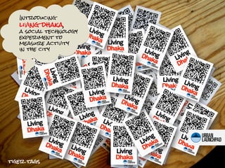
1. Introducing
living dhaka,
a social technology
experiment to
measure activity
in the city
tiger tags
2. a tiger tag is just a piece of paper with a qr code
embedded with a unique but anonymous id e.g.
bengaltiger445
Living
Dhaka
3. when an individual carries it, he or she becomes a tiger who
can then be tracked by smartphone carrying volunteers.
4. one scan can log a host of information on those tigers
4:59 pm (time)
smiling
(happiness)
23.70, 90.44 (location)
walking (transport mode)
5. which can then be sent into the cloud and aggregrated to
produce measurements like the following which we tested at mit
6. Living Showcase at MIT | Nov17,2011
where the tigers roamed when the tigers came and
went, how long they stayed
the relationship btwn what
what the tigers were interested in they liked and where it was
located
7. Living Showcase at MIT | Nov17,2011
6 smartphones, 8 volunteers, 140 tigers
total cost - $200
(t-shirts, printing zebra tags, phones borrowed)
development time – 4 (long) days, 1-2 people
Living Dhaka | weekofJanuary12, 2012
50 smartphones, 100 volunteers, x tigers?
total cost - $10-20,000
we’d like to measure things not normally
measured (e.g. pedestrian flows, bus ridership,
cycle rickshaw flows) and understand how both
the measurements themselves and the social
process of measurement is received by the city
development time – 2 months
8. Living Dhaka | weekofJanuary12, 2012
Old Dhaka Pedestrian Density & Flows
10 AM 1 PM 6 PM
(LARGER SCALE)
experimental design
50 scanners at 25 fixed nodes main pedestrian
3 separate scanning times
corridors
color of dots = high no. of scans/
minute
9. Living Dhaka | weekofJanuary12, 2012
Firmgate Bus Ridership and Speeds
estimated
speeds
experimental design
<5 km/h
50 scanners
@ 6 fixed nodes
size of colors represents tap-outs
number of people alighting
from those stops from
farmgate
speed calculated by
average of consecutive 5-10 km/h
scans
10-15 km/h
tap-ins
6 PM
(MEDIUM SCALE)
10. Living Dhaka | weekofJanuary12, 2012
Dhanmondi Lake
Happiness and Density Map
experimental design
50 roaming scanners
1 scanning time at peak
time
favorite spots
blue color = places of
highest number of happy
people
8 PM
(MEDIUM SCALE)
11. Living Dhaka | weekofJanuary12, 2012
we’d like to measure before and after an
experiment that improves car-free travel*
Before After
did this experiment work?
would data change your mind?
* are there any experiments that improve car-free travel in
dhaka that can be measured in mid-january?
13. Collaborators
Albert Ching is an aspiring urban innovator, a lifelong Hawaiian and former
Googler based in Mountain View, Hyderabad and Singapore. Albert is enduring
the frigid cold of Boston to help cities innovate, specifically by using the
proliferation of information technologies to solve transport problems in South
and Southeast Asia. He is a researcher for the Singapore-MIT Alliance’s Future
of Urban Mobility project. www.mrching.blogspot.com
Stephen Kennedy is a designer and artist formerly based in Atlanta with a
background in Industrial Design from Georgia Tech. At first a reluctant
transplant to Boston, Stephen has enjoyed trying to escape frigid New
England by working as a hybrid planner-designer on signage initiatives in New
Orleans, greenway planning in the Bronx, urban realm technology in
Thessaloniki, and participatory planning in Indonesia. His focus is on both
physical planning and spatial information design.
www.stephenjameskennedy.com
Muntasir Mamun Imran is a nature lover, adventure-trekker, and an
experienced social entrepreneur from Bangladesh. He is the co-founder of
Kewkradong Bangladesh, country coordinator for the Ocean Conservancy’s
International Coastal Cleanup, and Organizer of the Banff Mountain Film
Festival World Tour. He has organized cycling rides throughout Bangladesh
including the Sir Edmund Hillary Ride, the Ride for Green, and the
LiveStrong Ride. www.muntasirmamun.com/
14. Advisors
P. Chris Zegras is the Ford Assistant Professor of Urban Planning and
Transportation at MIT. His research interests include the influence of the built
environment on individual travel behavior, transportation infrastructure and
system financing, indicators of sustainable transportation, and mitigating
transportation greenhouse gas emissions. On these and other related topics,
he has consulted widely, including for the World Bank, the Inter-American
Development Bank, the Canadian, German, US, and Peruvian Governments,
the World Business Council for Sustainable Development, and the United
Nations Center for Regional Development.
Zia Wadud is an Associate Professor in Civil Engineering at the Bangladesh
University of Engineering and Technology (BUET). Zia completed his PhD
from Imperial College London in Civil Engineering Policy in 2008 as a
Commonwealth Scholar and held research positions at the University of
Cambridge and at Massachusetts Institute of Technology. Zia’s current
research interests are in modeling and valuation of policy interventions in
the transportation and environment sector (including climate change
policy), modeling energy demand and assessing risk and vulnerability in the
context of broader Civil Engineering topics.
17. why dhaka?
small window of opportunity to avoid car-centric
development but need creative solutions that employ a
limited number of smartphones
mobile phones
window of opportunity smartphones
penetration
Chicago
Sydney
cars
48% Bangkok
Jakarta
auto lock-in line (10-20%)
1%
<1%
time
Dhaka
today
18. We have big ambitions . . .
Can the mayor of Dhaka run his city like an MIT
scientist managing a lab of experiments?
we are
here Feelings à Decisions
Data à Decisions
People à Data à Visualizations à
rebranding car alternatives + the city
à Decisions
Experiments -> measurement
(through people and phones) à
Iteration à Remeasurement à new
experiments à repeat à rinse ->
where we’d like repeat faster
cities to be
zebra tags
19. but there’s a lot we don’t know
finish
4 SUSTAINABLE
zebra tags as a store
3 IMPACT of commercial value
data -> decisions integration with
mobile payments
people à data à
visualizations à incentives to motivate
rebranding car users to scan
2 MEASUREMENT alternatives + the city
à decisions value to local
start businesses and
measure pre- and post- transport providers
experiments ->
experiments
measurement
how to tell if there is a
1 SOCIAL (through people and
difference?
phones) à Iteration à
TECHNOLOGY Remeasurement à new
measure things
experiments à repeat
Social otherwise difficult to
à rinse -> repeat
will people in dhaka measure
faster
want to be how often the rich and
measured? in what poor meet
format? how
should volunteers make visible the invisible
be organized and pedestrians, cycle
motivated? rickshaws, the poor, the
aged
technology
will the technology
work as planned in
dhaka? how fast
can the system be
rapidly iterated on
and deployed?
20. Living Dhaka | weekofJanuary12, 2012
1 PRINT QR 2 DISTRIBUTE 3 SCAN 4 REGISTER
BADGES TO CITIZENS CITIZENS IN CITIZENS AT
OUTSIDE TARGET AREA NOTABLE
TARGET AREA POINTS
Measurement Process
21. Living Dhaka | weekofJanuary12, 2012
1 NO. OF 2 SCANNING 3 FIXED vs. 4 SIZE OF
SCANNERS TIME FLEXIBLE MEASUREMENT
SCANNERS AREA
target is 50 target is <1 second
10 teams of 5 fixed
single street or
few blocks
peak capacity =
50 x 60
= 300 data points per large neighborhood
minute, or 18,000 per or street network
hour flexible
Measurement Variables
22. The Urban Launchpad is a MIT-started social mission-driven company /
research lab aspiring to accelerate experimentation and innovation in cities
through rapid prototyping and performance measurement on an urban scale