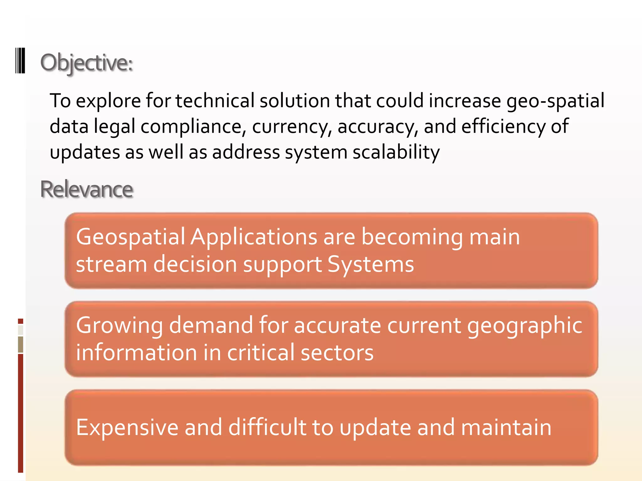
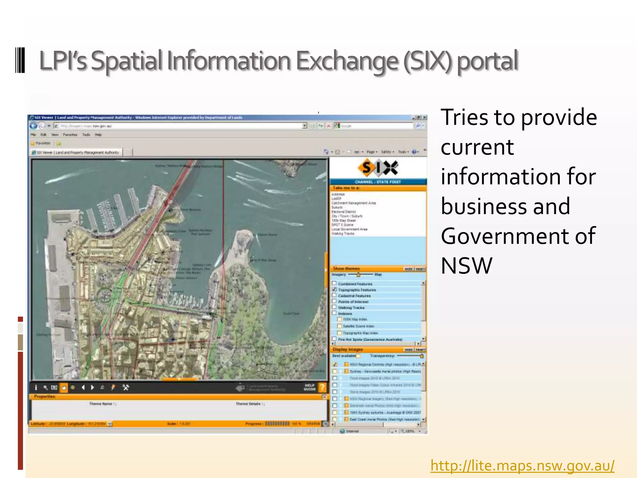
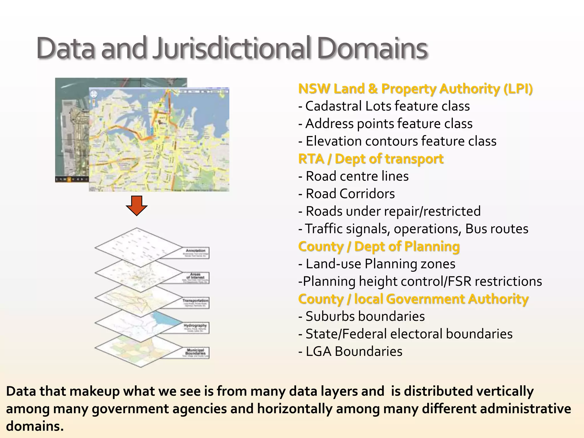
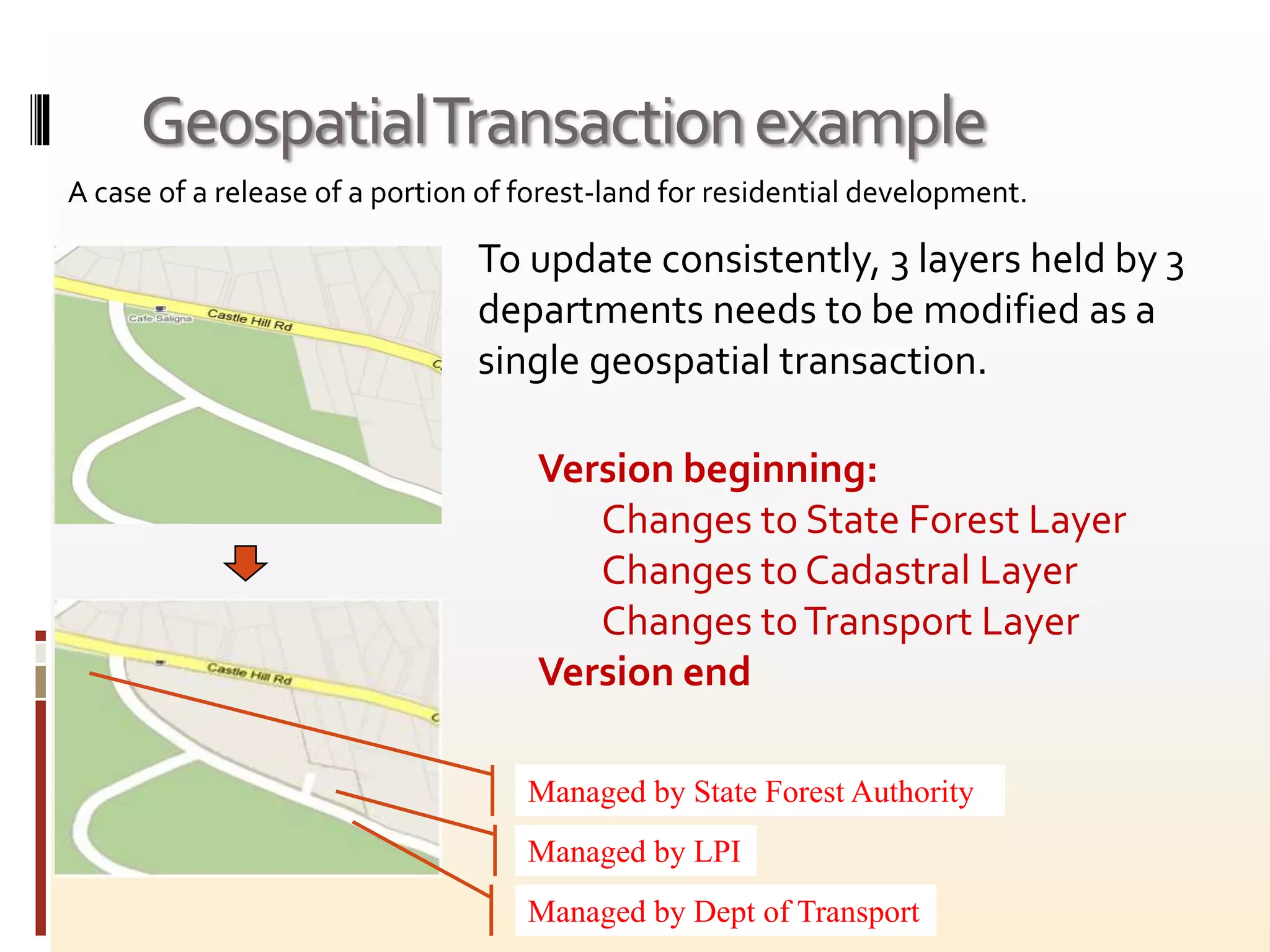
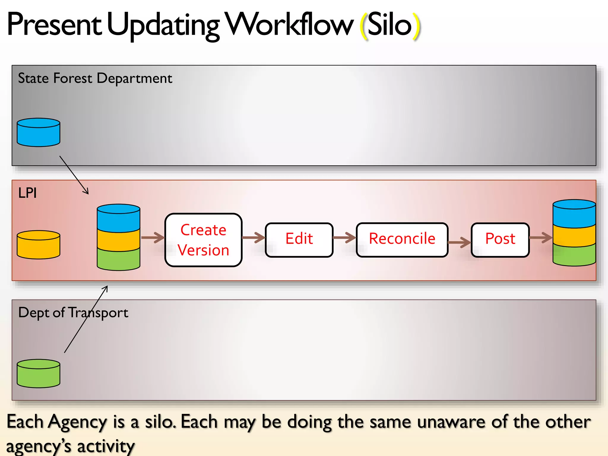
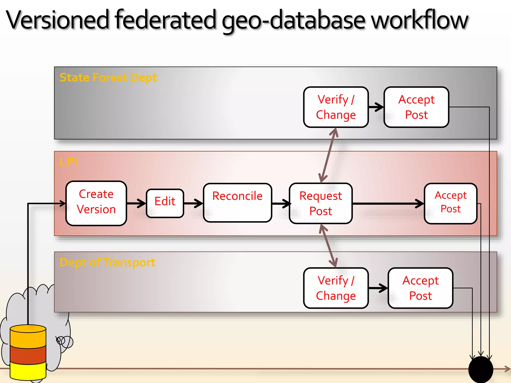
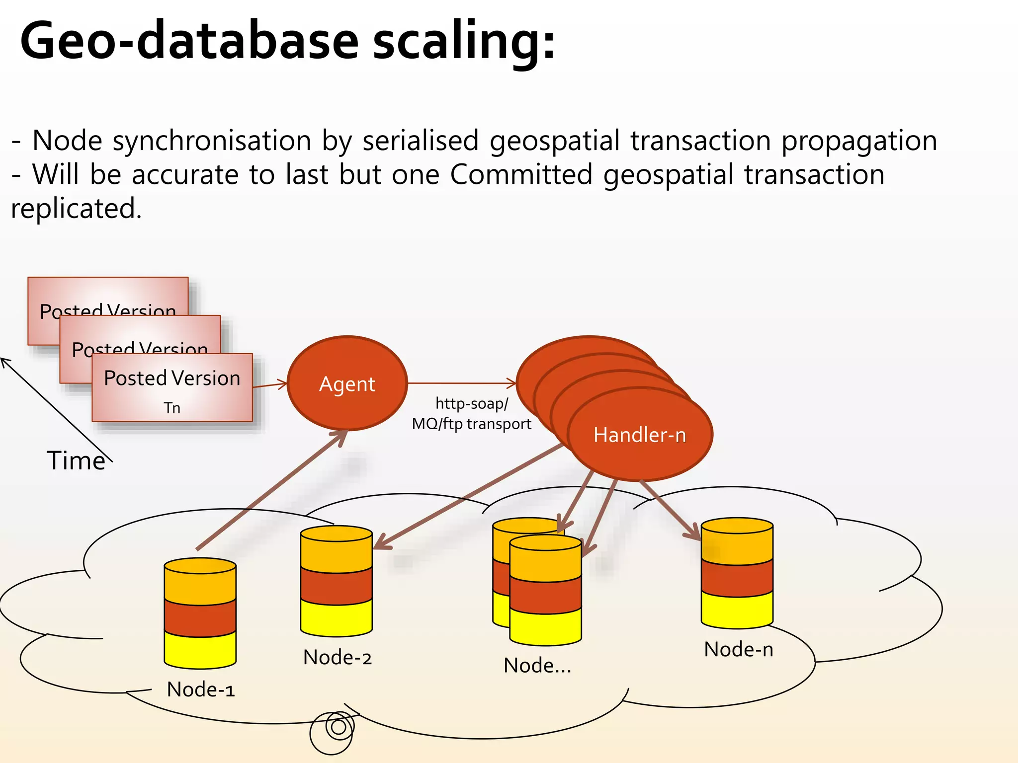
technical solution that could increase geo-spatial data legal compliance, currency, accuracy, and efficiency of updates as well as address system scaling for performance
This document summarizes a freight journey planning presentation. It discusses a freight journey planner that routes vehicles based on factors like date, time, vehicle dimensions, and restrictions. The planner provides routing options to drivers via connected satnav applications. It also offers a testing platform and routes gateway for operators to access routing data and customize solutions. The presentation concludes by providing contact information for PIE Mapping, the company behind the freight journey planning tools.
Using Workbench & FME Server to Validate Storm Water Network CollectionSafe Software
The document discusses a project by the Regional Municipality of York to validate storm water network collection data using FME Workbench and FME Server. It provides background on York Region and the presenter Bryan Bingham. The project aims to update storm water asset data from scanned drawings into a GIS using video logging and surveyors. FME Server is used for QA/QC through attribute validation, and FME Workbench is used for attribution, asset ID assignment, and calculating upstream/downstream nodes. Future steps include adding more asset types and dynamic domain checking.
A presentation focused on how Stadtwerke Münster, a public transit authority in Germany, used FME to efficiently transform timetables and bus route data into the General Transit Feed Specification (GTFS) used by Google Transit.
See more presentations from the FME User Conference 2014 at: www.safe.com/fmeuc
From Flat Files to Usable Deliverables: FME Empowers TransitSafe Software
BC Transit uses FME to transform and analyze transportation data from various sources into usable formats and deliverables. FME allows BC Transit to automate processes for naming bus stops, building bus route paths from GTFS and stop data, displaying automated passenger count data, and more. FME gives BC Transit control over its data processing and the ability to customize outputs based on available data and needs.
A geospatial approach to analyzing real estate values - Case Study: King's Cr...Tarik Dixon, GISP
This presentation seeks to apply GIS technology in order to determine the impact of transit oriented development (TOD) on existing property values in urban areas
Creating a Hydrological Network for the Yukon TerritorySafe Software
The Fisheries Information Summary System (FISS) is a Federal and Provincial geo-database that provides summary level, fish and fish habitat information for waterbodies throughout the province of British Columbia. Information is georeferenced using online digitizing tools and is linked to the BC 1:50,000 watershed atlas using a hierarchical watershed coding system. Using FME, a similar watershed atlas was created for the entire Yukon Territory at a fraction of the cost and time using the Horton Order transformer and other tools. The resulting intelligent hydrolgical network is now available for the Yukon through the Community Mapping Network at www.cmnbc.ca. We will describe some of the challenges encountered in the creation of the hydrological network and provide and overview of the new Yukon FISS system.
This document provides an overview and status update of West Virginia's State Freight Plan. It discusses the plan's process, which involves identifying critical freight infrastructure through data analysis and stakeholder outreach. Key steps completed so far include collecting freight data, conducting a freight industry survey, and developing a draft freight network map. Upcoming steps will identify potential freight projects and prioritize them based on their ability to enhance the state's multimodal freight system and economy. The document outlines federal requirements for state freight plans and how West Virginia's plan aligns with the goals of improving freight mobility, safety, and economic opportunities.
This document summarizes a research project to develop a geographic information system (GIS) of petrochemical transmission pipelines in the Lafayette, Louisiana area. The GIS provides vital data for emergency response, environmental research, and critical infrastructure protection. Researchers collected pipeline map data, took GPS points of pipeline crossings, and developed accurate digital pipeline features. Data compilation was challenging due to errors in existing maps. The final GIS contains pipeline data for 26 operators in the study area and was delivered on a CD along with a report.
This document provides an update on open data initiatives in Greater Manchester. It discusses plans to release Metrolink fare data, road traffic accident data, bus route mapping data, and real-time data feeds for car parks, Metroshuttle buses, and Metrolink trams. Challenges and timelines are outlined for making various transit and traffic datasets openly available in open data formats. Approval is still needed for some datasets, and development is ongoing to establish an architecture using Microsoft's Windows Azure cloud platform to host real-time transportation data.
The Strategic Surface Route Plan (SSRP) determines the route designations for over-ocean cargo movements between the continental United States (CONUS) and outside the continental United States (OCONUS) for various Combatant Commands and Department of Defense agencies. The SSRP directs the consolidation of cargo into pure or mixed cargo lanes at consolidation and containerization points and the deconsolidation of cargo at transportation control and support points. The SSRP aims to minimize distribution costs while improving service through aggregating demand information and stakeholder input.
The document discusses South Africa's plans to improve and expand its passenger rail network through 2030. It outlines the challenges faced by the rail system and introduces a priority corridor strategy to focus improvements. A turnaround strategy is presented in three phases from 2007-2030, aimed at stabilizing, recovering, and growing passenger rail ridership through investments in infrastructure, rolling stock, and new/expanded services. Key projects discussed include the Bridge City Rail Link in Durban and proposed rail links to Cape Town International Airport.
This document summarizes a presentation given by Bob Smith, the Director of Asset Management and Planning at Arizona Public Service Company (APS), about major transmission projects in the Western United States. It provides an overview of APS's service area and 10-year transmission plan, including details on the Hassayampa-North Gila 500kV project currently underway. It also discusses regional transmission planning through the WestConnect collaborative, outlining participating members and summarizing key findings and projects from their 2014 transmission plan.
LTC, Jack R. Widmeyer Transportation Research Conference, Going to San Bernar...LTC @ CSUSB
This document summarizes lessons learned from the first generation of transit-oriented developments (TODs) in California and trends emerging in the second generation. Key points include: Successes of early TODs included integration with existing transit and land use plans. Weaknesses included poor connectivity and a focus on inexpensive land far from stations. Studies show TOD residents use transit more but rates vary by location. Emerging best practices focus on multidestination transit networks, coordinated planning, and expanding TOD to bus and commuter rail. Remaining challenges include economic conditions, community opposition, and reforming local plans.
The document summarizes the Bus Rapid Transit (BRT) project for the City of Tshwane, South Africa. The BRT project will have two phases and will consist of two main routes, lines 1 and 2, covering a total distance of 67.6 km. It will include 52 stations along the routes. The BRT system is aimed to meet the public transportation demands and connect communities with employment and commercial areas. Some challenges of the project include incorporating existing public transportation operators, acquiring buses that meet specifications, and addressing infrastructure requirements within set timeframes.
Recent transportation studies for the kern regiondirectionsto2050
The document provides an overview of several recent studies related to transportation in Kern County, California. These include a Bicycle Master Plan, Long Range Transit Plan, HOV/BRT Study, Commuter Rail Feasibility Study, Short Haul Rail Freight Study, and Goods Movement Strategy. The plans examine expanding bicycle infrastructure, improving and expanding bus and potential rail services, increasing high-occupancy vehicle lanes, and addressing goods movement needs over the next 20 years to accommodate projected population and employment growth. Recommendations include new bike lanes, rapid bus routes, express bus routes, HOV lanes, potential future light rail or commuter rail, and highway expansion projects.
Transportation Sub-Committee Meeting of 10 Dec 08 reports on alternatives and their ramifications to improving road congestion in Hampton Roads and the need to be ready to claim infrastructure stimulus money from the Obama administration. http://www.vmasc.odu.edu
The document summarizes a study of transportation options for commuters traveling between Saratoga and Albany, New York. It evaluates existing Northway Express services and alternatives like commuter rail, light rail, and bus rapid transit. It recommends improvements to existing bus services and pursuing commuter rail and bus rapid transit options in the River Corridor, with further analysis and development of those projects. Specifically, it calls for restructuring bus routes, increasing bus frequency, and constructing commuter rail stations in the near term, with additional enhancements like dedicated bus lanes and expanded commuter rail services in the long term.
This document summarizes an active transportation project in Nova Scotia. It outlines the project team members, data sources used, key deliverables including maps of existing and proposed active transportation corridors. It also discusses challenges with active transportation in Nova Scotia and provides examples of maps produced for the towns of Wolfville and Windsor showing population density and active transportation infrastructure. Analysis was conducted in ArcGIS and maps were published on ArcGIS Online.
LTC, Jack R. Widmeyer Transportation Research Conference, Going to San Bernar...LTC @ CSUSB
California manages over 50,000 miles of highways and freeways with over 150 billion vehicle miles traveled annually. The California Department of Transportation (Caltrans) operates traffic management centers (TMCs) in each district to monitor traffic conditions using sensors and video surveillance. The California Highway Patrol is co-located in the TMCs and uses its computer-aided dispatch system to track incidents. Caltrans coordinates traffic management between districts by changeable message signs, phone calls, and sharing incident logs. The document recommends that agencies leverage local resources through coordination, share data comprehensively, and prepare standard operating procedures for incidents like planned diversions.
This document discusses performance measures for highway capacity decision making. It outlines national goals in the Moving Ahead for Progress in the 21st Century Act related to safety, infrastructure condition, congestion, and more. It then discusses the KYOVA Interstate Planning Commission's use of performance measures from its metropolitan transportation plan, congestion management process, and spatial decision support system. Finally, it presents a case study on North Carolina's prioritization process, which uses benefit-cost criteria and travel time savings analysis to evaluate highway projects. There is an opportunity to integrate microsimulation modeling into KYOVA's project prioritization similarly.
This document discusses freight planning efforts by the KYOVA Interstate Planning Commission. It provides an overview of the commission's responsibilities and requirements as a Transportation Management Area. These include developing a Congestion Management Process, Integrated Metropolitan Transportation Plan, and Integrated Transportation Improvement Program. The document outlines past and ongoing freight planning activities, including developing performance measures and a Spatial Decision Support System to analyze freight movement. It also discusses expectations for future freight planning, including developing a KYOVA Freight Plan by fiscal year 2018.
Adding capacity on the Steel Railway - Railway Gazette InternationalMRS Logística
MRS Logística has completed installing communications-based train control (CBTC) on its busy Steel Railway in Brazil, providing more capacity and safety improvements. The CBTC system allows the railway to monitor train positions continuously and manage shorter distances between trains. This has increased line capacity by 10% by allowing "dynamic blocks" as short as 1 km between trains compared to the previous 9 km. The CBTC implementation also improves safety, reduces operating costs, and provides maintenance benefits through remote equipment monitoring.
"Key infrastructure technologies for sustained human exploration of the Moon ...Marco Lisi
My presentation "Key infrastructure technologies for sustained human exploration of the Moon and Mars"at the workshop Space Horizons 2015, "McMurco on the Moon", February 18-19, 2015, Brown University
Keep it moving - construction phase transport planningJumpingJaq
Mark Stone discusses construction phase transport planning in 3 key areas:
1) The primary goal is to minimize impacts on existing transport users and maintain safe access during construction projects.
2) Case studies in Melbourne show how stakeholder engagement, adaptive infrastructure changes, and communication plans can deliver projects on time and under budget with minimal complaints.
3) Emerging opportunities like travel demand modeling and route optimization can further reduce disruption through innovative planning and monitoring tools.
This document provides an overview of the Geospatial Transportation Information Section of the West Virginia Department of Transportation. It summarizes their work in roadway inventory data processing and maintenance, centralized roadway geometry, mapping and GIS services, and GIS applications. It also outlines several of their current and future projects including web mapping portals, a GIS versioning model, integration with Primavera project management software, and fleet management using GPS and telematics.
Kymeta has been developing products aimed at bringing affordable high-speed data service to mobile locations such as planes, trains, oil rigs and vehicles.
Kymeta’s satellite terminals have a proprietary beam-steering antenna design based on synthetic metamaterials, which can bend electromagnetic waves in ways that natural materials can’t. The antennas are flat; the smallest is about the size and shape of a laptop. They are equipped with an array of metamaterial elements that can be electronically tuned to maintain a satellite connection.
This is a non-NDA version of a presentation on Kymeta developed for the Satellite2013 industry conference in March. The original had many animations - I have replaced these with screen grabs where possible.
The document discusses network transport evolution at a telecommunications provider. It covers trends like increasing packet traffic, the benefits of coherent detection in DWDM networks, and strategies for deploying 100G channels. It also debates the relative merits of using OTN switching versus router-based switching in the network backbone for efficiency and fast restoration, noting challenges of each approach. Maintaining support for legacy interfaces is also discussed.
Virtual Network System: Splitting Control and Data Plane to Optimize IP and T...Ericsson
The document discusses the Virtual Network System (VNS) which splits the control plane and data plane to optimize IP and transport services. This helps deal with increasing network scale and complexity at lower operational expenses. Key points discussed include:
- VNS logically represents a full cluster/region as a single entity to simplify management and topology hiding.
- The centralized control plane can act on behalf of nodes in access/aggregation to provide homogenous data plane and control plane consolidation.
- Demo of VNS in Ericsson booth shows auto-provisioning of transport for a new customer site by adding hardware and configuring through the centralized controller.
- Analysis shows VNS controller capabilities can meet restoration timescales of 50
[Foss4 g2013]the architecture of mobile traffic map service finalBJ Jang
This document describes the architecture of a mobile traffic map service run by NTIC (National Transport Information Center) in Korea. It discusses improvements made between 2011-2013 to support more users and address performance issues. The initial 2011 system struggled with heavy loads. The 2012 system improved by using tiled maps, caching, and SQL Server. However, load issues remained. The 2013 system optimized further by pushing pre-generated map tiles to caching servers and updating only changed tiles. These changes improved user support from 200k to 300k daily and greatly enhanced scalability. Lessons included validating open source GIS performance before adoption.
ASON – Automatically Switched Optical Networks
Dynamically switch the light path
Enabler for many applications
Controlled by UNI and NNI – Allow applications to set the light path
Allow to add the intelligence into the optical core
ASON:
The Automatic Switched Optical Network (ASON) is both a framework and a technology capability.
As a framework that describes a control and management architecture for an automatic switched optical transport network.
As a technology, it refers to routing and signalling protocols applied to an optical network which enable dynamic path setup.
Recently changed names to Automatic Switched Transport Network (G.ASTN)
Enabling Active Flow Manipulation (AFM) in Silicon-based Network Forwarding E...Tal Lavian Ph.D.
Programmable Internet:
Enhance internetworking functions.
Move computations into the network for value added services.
Manage the network more capably than possible with SNMP.
More quickly introduce Diffserv or Inserv to support new multimedia applications
Implement traffic control algorithms to support QoS.
This document discusses Uber's stream processing pipeline. It describes how Uber uses stream data to understand city dynamics in real-time. The pipeline includes using Elasticsearch to query dimensional temporal spatial data, Apache Samza for distributed processing, and complex event processing to detect patterns like drivers canceling requests repeatedly. The challenges of large data volumes, varied queries, and tight latency requirements are also addressed.
Business Model Concepts for Dynamically Provisioned Optical NetworksTal Lavian Ph.D.
Business Continuity/Disaster Recovery:
Remote file storage/back-up
Recovery after equipment or path failure
Alternate site operations after disaster
Storage and Data on Demand:
Rapid expansion of NAS capacity
Archival storage and retrievals
Logistical networking – pre-fetch and cache
Financial Community and Transaction GRIDs:
Distributed computation and storage
Shared very high bandwidth network
Pay-for-use utility computing
FME Around the World (FME Trek, Part 2): Ciaran Kirk - Safe Software FME Worl...IMGS
Aim: "To seek out innovative FME users
throughout the galaxy, sharing
their stories and ideas to inspire
you to take your data where no
data has gone before."
The document discusses the role of geographic information systems (GIS) in Next Generation 9-1-1 (NG9-1-1). GIS will play a critical role by providing location data for 9-1-1 call routing and validation. Several states and regions are implementing or planning NG9-1-1 GIS systems to support geo-spatial call routing and location validation functions. Standards-compliant GIS data will need to be aggregated and managed to support new NG9-1-1 capabilities.
FME Around the World (FME Trek Part 1): Ken Bragg - Safe Software FME World T...IMGS
Aim: "To seek out innovative FME users
throughout the galaxy, sharing
their stories and ideas to inspire
you to take your data where no
data has gone before."
The document summarizes using FME for several mapping and geospatial data projects. It describes using FME to generate web map tiles from meteorological forecast models for Pelmorex in near real-time. It also discusses using FME Cloud to dynamically provision compute capacity for tile generation every 12 hours to process large amounts of data. Finally, it mentions that the approach costs $80 per run compared to $300,000 if done on-premises.
PLNOG 6: Bart van der Sloot - Technology trends in terrestrial and subsea net...PROIDEA
This document discusses technology trends to address ongoing growth in internet traffic. It begins with an overview of Global Crossing, a tier 1 internet backbone provider. It then discusses the exploding growth in internet traffic driven by user demand. Looking forward, new transport technologies like ultra long haul are needed to address this growth and reduce costs per megabit as traffic increases. Ultra long haul uses technologies like advanced modulation, coherent detection, and low loss Raman amplification to allow optical signals to travel longer distances at lower costs. This will help transport costs align with price erosion in the IP transit market and allow global internet backbones to scale efficiently.
PLNOG16: Data center interconnect dla opornych, Krzysztof MazepaPROIDEA
This document discusses data center interconnect (DCI) solutions for extending layer 2 domains across multiple sites. It introduces Overlay Transport Virtualization (OTV) as an IP-based solution that uses "MAC in IP" techniques to extend layer 2 connectivity over any transport network while containing failures and preserving resiliency. OTV uses control-plane learning and IS-IS routing to advertise MAC reachability between sites and elect a single edge device per VLAN to forward traffic. This allows OTV to provide layer 2 extensions across metro or global distances while isolating spanning tree domains and preventing unknown unicast flooding beyond site boundaries.
The Utility Network is the on the horizon. Duane Holt from Intermountain Rural Electric Association (IREA) has had a chance to use the beta of the Utility Network. He will share his experience and give his positives and negatives of this new technology. John Coleman from SSP Innovations, an Esri partner, will demonstrate the tools they have been building to answer the questions and concerns IREA and other utilities have about the Utility Network. This will include a few demonstrations covering each of the topics that IREA experienced during the Utility Network jumpstart.
This document summarizes a presentation about using the Utility Network for managing electric utility infrastructure data. It discusses Intermountain Rural Electric Association's current GIS status and plans for an AMI rollout, CIS upgrades, and inventory projects. The presentation then focuses on migrating IREA's data to the Utility Network and testing functionality in a beta environment. It addresses concerns about creating features and tracing in the Utility Network and demonstrates how new tools can help increase productivity and visualize associations between entities.
This document discusses how GIS technology is being used to manage large amounts of data for flood control projects in Mecklenburg County, North Carolina. It manages data from over 300 square miles of projects through a centralized database called CECAP. This process streamlines relationships between different agencies and consolidates data from various sources into a single location for easy access. The document provides two case studies that demonstrate how GIS is used to organize massive amounts of survey data, planning data, design data, and more for complex residential and urban stormwater retrofit projects.
VEHICULAR 2020 Presentation by Kohei HosonoKohei Hosono
Title:
Implementation and Evaluation of Priority Processing by Controlling Transmission Interval Considering Traffic Environment in a Dynamic Map
Author:
Kohei Hosono, Akihiko Maki, Yoichi Watanabe, Hiroaki Takada, Kenya Sato
Affiliation:
Computer and Information Science, Graduate School of Science and Engineering, Doshisha University
Fujitsu Limited
Institutes of Innovation for Future Society, Nagoya University
Mobility Research Center, Doshisha University
Conference:
The Ninth International Conference on Advances in Vehicular Systems, Technologies and Applications VEHICULAR 2020
Abstract:
Much attention has been attracted to the research of cooperative automatic driving that focuses on safety and efficiency by sharing the data obtained from sensor information of a vehicle. In addition, dynamic maps, a common information and communication platform for the integrated management of shared sensor information, are under consideration. A vehicle always sends data to a server that manages the dynamic map, and the server runs applications for driving support and control on the basis of the data, so fast information processing is required. However, congestion is a concern when data is continuously sent from vehicles to the server at high transmission intervals and when many vehicles are managed by dynamic maps on the server. In addition, the data transmission interval from the vehicle required by the road characteristics differs in actual traffic environments. Therefore, congestion can be alleviated by adjusting the transmission interval of data from the vehicle in consideration of road characteristics. In this paper, a platform for a dynamic map consisting of a server and a vehicle is constructed. We have also implemented a priority processing function that sets the priority for each section of a lane, and adjusts the transmission interval on the basis of the characteristics of the road around the vehicle.
This document discusses resource allocation and quality of service (QoS) for cellular communications systems operating in congested environments. It proposes designing radio resource allocation (RRA) mechanisms that can optimize for meeting different traffic types' bit rate requirements while accounting for their elasticity behaviors. The author proves that relaxing real-time traffic utilities into a sigmoidal form leads to a convex optimization problem, allowing for efficient resource allocation. Large-scale simulations are performed to test the RRA mechanisms under realistic channel conditions and network deployments.
The San Francisco County Transportation Authority uses several apps and online tools to engage the public in transportation planning, including MyStreetSF.com, sfbudgetczar.com, and CycleTracks. These tools receive thousands of user submissions providing data on transportation issues and preferences. However, users tend to be overrepresented by ages 25-40, white, higher-income residents. The Authority analyzes user data along with other sources to inform planning of bicycle networks and facilities, transit funding priorities, and regional transportation modeling.
Similar to Up to-date geographic data management (20)
Dandelion Hashtable: beyond billion requests per second on a commodity serverAntonios Katsarakis
This slide deck presents DLHT, a concurrent in-memory hashtable. Despite efforts to optimize hashtables, that go as far as sacrificing core functionality, state-of-the-art designs still incur multiple memory accesses per request and block request processing in three cases. First, most hashtables block while waiting for data to be retrieved from memory. Second, open-addressing designs, which represent the current state-of-the-art, either cannot free index slots on deletes or must block all requests to do so. Third, index resizes block every request until all objects are copied to the new index. Defying folklore wisdom, DLHT forgoes open-addressing and adopts a fully-featured and memory-aware closed-addressing design based on bounded cache-line-chaining. This design offers lock-free index operations and deletes that free slots instantly, (2) completes most requests with a single memory access, (3) utilizes software prefetching to hide memory latencies, and (4) employs a novel non-blocking and parallel resizing. In a commodity server and a memory-resident workload, DLHT surpasses 1.6B requests per second and provides 3.5x (12x) the throughput of the state-of-the-art closed-addressing (open-addressing) resizable hashtable on Gets (Deletes).
How information systems are built or acquired puts information, which is what they should be about, in a secondary place. Our language adapted accordingly, and we no longer talk about information systems but applications. Applications evolved in a way to break data into diverse fragments, tightly coupled with applications and expensive to integrate. The result is technical debt, which is re-paid by taking even bigger "loans", resulting in an ever-increasing technical debt. Software engineering and procurement practices work in sync with market forces to maintain this trend. This talk demonstrates how natural this situation is. The question is: can something be done to reverse the trend?
Digital Banking in the Cloud: How Citizens Bank Unlocked Their MainframePrecisely
Inconsistent user experience and siloed data, high costs, and changing customer expectations – Citizens Bank was experiencing these challenges while it was attempting to deliver a superior digital banking experience for its clients. Its core banking applications run on the mainframe and Citizens was using legacy utilities to get the critical mainframe data to feed customer-facing channels, like call centers, web, and mobile. Ultimately, this led to higher operating costs (MIPS), delayed response times, and longer time to market.
Ever-changing customer expectations demand more modern digital experiences, and the bank needed to find a solution that could provide real-time data to its customer channels with low latency and operating costs. Join this session to learn how Citizens is leveraging Precisely to replicate mainframe data to its customer channels and deliver on their “modern digital bank” experiences.
HCL Notes und Domino Lizenzkostenreduzierung in der Welt von DLAUpanagenda
Webinar Recording: https://www.panagenda.com/webinars/hcl-notes-und-domino-lizenzkostenreduzierung-in-der-welt-von-dlau/
DLAU und die Lizenzen nach dem CCB- und CCX-Modell sind für viele in der HCL-Community seit letztem Jahr ein heißes Thema. Als Notes- oder Domino-Kunde haben Sie vielleicht mit unerwartet hohen Benutzerzahlen und Lizenzgebühren zu kämpfen. Sie fragen sich vielleicht, wie diese neue Art der Lizenzierung funktioniert und welchen Nutzen sie Ihnen bringt. Vor allem wollen Sie sicherlich Ihr Budget einhalten und Kosten sparen, wo immer möglich. Das verstehen wir und wir möchten Ihnen dabei helfen!
Wir erklären Ihnen, wie Sie häufige Konfigurationsprobleme lösen können, die dazu führen können, dass mehr Benutzer gezählt werden als nötig, und wie Sie überflüssige oder ungenutzte Konten identifizieren und entfernen können, um Geld zu sparen. Es gibt auch einige Ansätze, die zu unnötigen Ausgaben führen können, z. B. wenn ein Personendokument anstelle eines Mail-Ins für geteilte Mailboxen verwendet wird. Wir zeigen Ihnen solche Fälle und deren Lösungen. Und natürlich erklären wir Ihnen das neue Lizenzmodell.
Nehmen Sie an diesem Webinar teil, bei dem HCL-Ambassador Marc Thomas und Gastredner Franz Walder Ihnen diese neue Welt näherbringen. Es vermittelt Ihnen die Tools und das Know-how, um den Überblick zu bewahren. Sie werden in der Lage sein, Ihre Kosten durch eine optimierte Domino-Konfiguration zu reduzieren und auch in Zukunft gering zu halten.
Diese Themen werden behandelt
- Reduzierung der Lizenzkosten durch Auffinden und Beheben von Fehlkonfigurationen und überflüssigen Konten
- Wie funktionieren CCB- und CCX-Lizenzen wirklich?
- Verstehen des DLAU-Tools und wie man es am besten nutzt
- Tipps für häufige Problembereiche, wie z. B. Team-Postfächer, Funktions-/Testbenutzer usw.
- Praxisbeispiele und Best Practices zum sofortigen Umsetzen
zkStudyClub - LatticeFold: A Lattice-based Folding Scheme and its Application...Alex Pruden
Folding is a recent technique for building efficient recursive SNARKs. Several elegant folding protocols have been proposed, such as Nova, Supernova, Hypernova, Protostar, and others. However, all of them rely on an additively homomorphic commitment scheme based on discrete log, and are therefore not post-quantum secure. In this work we present LatticeFold, the first lattice-based folding protocol based on the Module SIS problem. This folding protocol naturally leads to an efficient recursive lattice-based SNARK and an efficient PCD scheme. LatticeFold supports folding low-degree relations, such as R1CS, as well as high-degree relations, such as CCS. The key challenge is to construct a secure folding protocol that works with the Ajtai commitment scheme. The difficulty, is ensuring that extracted witnesses are low norm through many rounds of folding. We present a novel technique using the sumcheck protocol to ensure that extracted witnesses are always low norm no matter how many rounds of folding are used. Our evaluation of the final proof system suggests that it is as performant as Hypernova, while providing post-quantum security.
Paper Link: https://eprint.iacr.org/2024/257
Discover top-tier mobile app development services, offering innovative solutions for iOS and Android. Enhance your business with custom, user-friendly mobile applications.
Main news related to the CCS TSI 2023 (2023/1695)Jakub Marek
An English 🇬🇧 translation of a presentation to the speech I gave about the main changes brought by CCS TSI 2023 at the biggest Czech conference on Communications and signalling systems on Railways, which was held in Clarion Hotel Olomouc from 7th to 9th November 2023 (konferenceszt.cz). Attended by around 500 participants and 200 on-line followers.
The original Czech 🇨🇿 version of the presentation can be found here: https://www.slideshare.net/slideshow/hlavni-novinky-souvisejici-s-ccs-tsi-2023-2023-1695/269688092 .
The videorecording (in Czech) from the presentation is available here: https://youtu.be/WzjJWm4IyPk?si=SImb06tuXGb30BEH .
AppSec PNW: Android and iOS Application Security with MobSFAjin Abraham
Mobile Security Framework - MobSF is a free and open source automated mobile application security testing environment designed to help security engineers, researchers, developers, and penetration testers to identify security vulnerabilities, malicious behaviours and privacy concerns in mobile applications using static and dynamic analysis. It supports all the popular mobile application binaries and source code formats built for Android and iOS devices. In addition to automated security assessment, it also offers an interactive testing environment to build and execute scenario based test/fuzz cases against the application.
This talk covers:
Using MobSF for static analysis of mobile applications.
Interactive dynamic security assessment of Android and iOS applications.
Solving Mobile app CTF challenges.
Reverse engineering and runtime analysis of Mobile malware.
How to shift left and integrate MobSF/mobsfscan SAST and DAST in your build pipeline.
"Choosing proper type of scaling", Olena SyrotaFwdays
Imagine an IoT processing system that is already quite mature and production-ready and for which client coverage is growing and scaling and performance aspects are life and death questions. The system has Redis, MongoDB, and stream processing based on ksqldb. In this talk, firstly, we will analyze scaling approaches and then select the proper ones for our system.
[OReilly Superstream] Occupy the Space: A grassroots guide to engineering (an...Jason Yip
The typical problem in product engineering is not bad strategy, so much as “no strategy”. This leads to confusion, lack of motivation, and incoherent action. The next time you look for a strategy and find an empty space, instead of waiting for it to be filled, I will show you how to fill it in yourself. If you’re wrong, it forces a correction. If you’re right, it helps create focus. I’ll share how I’ve approached this in the past, both what works and lessons for what didn’t work so well.
How to Interpret Trends in the Kalyan Rajdhani Mix Chart.pdfChart Kalyan
A Mix Chart displays historical data of numbers in a graphical or tabular form. The Kalyan Rajdhani Mix Chart specifically shows the results of a sequence of numbers over different periods.
"Frontline Battles with DDoS: Best practices and Lessons Learned", Igor IvaniukFwdays
At this talk we will discuss DDoS protection tools and best practices, discuss network architectures and what AWS has to offer. Also, we will look into one of the largest DDoS attacks on Ukrainian infrastructure that happened in February 2022. We'll see, what techniques helped to keep the web resources available for Ukrainians and how AWS improved DDoS protection for all customers based on Ukraine experience
Energy Efficient Video Encoding for Cloud and Edge Computing Instances
Up to-date geographic data management
1. Kalyan K. Janakiraman
Land and Property Information / Macquarie University
kalyankj@gmail.com
Prof. Mehmet A Orgun
Department of Computing
Macquarie University, NSW
mehmet@comp.mq.edu.au
Dr. Abhaya Nayak
Department of Computing
Macquarie University, NSW
Abhaya@comp.mq.edu.au
2. Relevance
Geospatial Applications are becoming main
stream decision support Systems
Growing demand for accurate current geographic
information in critical sectors
Expensive and difficult to update and maintain
To explore for technical solution that could increase geo-spatial
data legal compliance, currency, accuracy, and efficiency of
updates as well as address system scalability
Objective:
4. DataandJurisdictionalDomains
NSW Land & Property Authority (LPI)
- Cadastral Lots feature class
- Address points feature class
- Elevation contours feature class
RTA / Dept of transport
- Road centre lines
- Road Corridors
- Roads under repair/restricted
-Traffic signals, operations, Bus routes
County / Dept of Planning
- Land-use Planning zones
-Planning height control/FSR restrictions
County / local Government Authority
- Suburbs boundaries
- State/Federal electoral boundaries
- LGA Boundaries
Data that makeup what we see is from many data layers and is distributed vertically
among many government agencies and horizontally among many different administrative
domains.
5. GeographicData–Transactionalperspective
• Typically, many DBMS transactions per geospatial
transactionLarge Atomicity:
• commonly takes many days to prepare and commit one
geospatial transaction
Multi-session,
Multi-user, long
transaction
• Direct – no concern for geospatial integrity
• Versioned– commonly used in most production
environments. 4 states: create version, edit, fix
conflicts (reconcile) and commit (Post)
• Local session -- OpenStreetMap uses
Versioned
Updating
6. GeospatialTransactionexample
A case of a release of a portion of forest-land for residential development.
Managed by State Forest Authority
Managed by LPI
Managed by Dept of Transport
To update consistently, 3 layers held by 3
departments needs to be modified as a
single geospatial transaction.
Version beginning:
Changes to State Forest Layer
Changes to Cadastral Layer
Changes toTransport Layer
Version end
7. GeographicTransactionsinNSW–2month
snapshotfromLPI
▪ 7756 geospatial transactions were recorded in LPI comprising 60 layers.
▪ One layer geospatial transaction: Only111occurrences
▪ Average: 9 layers, 118 changes per geospatial transaction.
▪ Maximum: 40 layers per geospatial transaction
▪ About 25% of edits (230,000 edits) - other agency data (unauthorized / redundant).
0
500
1000
1500
2000
2500
3000
3500
1
2to9
10-19
20-29
30-39
40-49
50-59
60-69
70-79
80-89
90-99
100-109
110-119
120-129
130-139
140-149
150-159
160-169
170-179
180-189
190-199
200-209
210-219
220-229
230-239
240-249
250-259
260-269
270-279
280-289
290-299
300+
Frequency
database transactions per geospatial transaction
9. Serialized geospatial transaction distribution
▪ Each geospatial transaction captured and applied to other repositories serially
▪ Serializability property does not hold. Each geospatial transaction need to be
applied in the same order as they occurred in the source repository.
PostedVersion
PostedVersion
PostedVersion
Tn
Agent Handler
Posted
VersionPosted
VersionPosted
Version Tn-3
http-soap/
MQ/ftp transport
Time
Node1 Node2
Janakiraman, K. K; Hansen, L, Orgun, M; "Failed-tuple blocking strategy for near-real time geospatial database
replication," Proceedings of the First conference on Computing for Geospatial Research & Application InternationalConference
on , vol., no., pp.__, 21-23 June 2010.
Failure handling:
14. @Entity
@Table(name = “suburb")
public class Suburb {
@Id
@GeneratedValue(strategy=GenerationType.IDENTITY)
@Column(name = "gid")
private Long id;
@Column(name = "name")
private String name;
@Column(name = "the_geom")
@Type(type =
"org.hibernatespatial.GeometryUserType")
private MultiPolygon geometry;
public MultiPolygon getPolygon() {
return geometry;
}
}
GET
Envelope box = //Window rectangle;
List<RLSuburb> stnList = (List<RLSuburb>)RLSuburbDao.get(box);
for (RLSuburb event : stnList) {
System.out.println(event);
}
GET OPERATION – EXAMPLE FOR SUBURB LAYER
Output:
MULTIPOLYGON (((30 20, 10 40, 45 40, 30 20)),…))
…
15. Cloudgeo-database:Versionmanagement
Version_id Version_name
Version_id layer Feature_id timestamp Owner_decision timestamp
Unique
ActiveVersions
Active changes
Version
Post Background
Agent
Commit is initiated when OWNER_DECISION
For all the changed feature for a version = POST
{RequestPost, notified, Reject, Post}
16. OverallCloudGeo-databaseArchitecture
▪ Cloud as a Database Service – agencies subscribe.
▪ one unique URL per geospatial Layer.
▪ Write access to custodian Agency.
▪ Read access to all subscribing agency.
▪ versioning managed by cloud.
▪ Any layer can participate in versioned updating.
▪ Non-authorised updates would propagate to the responsible
authority for consideration for update.
▪ Scaling through node synchronisation by serialised geospatial
transaction propagation.
▪ Authentication/Access control for agency+user combination