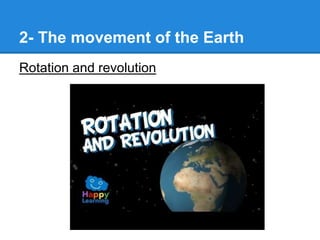
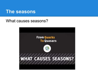
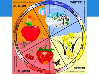
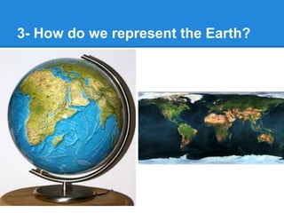
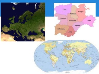
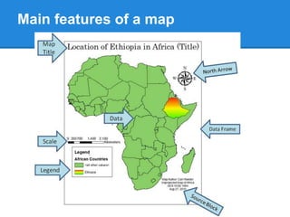
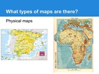
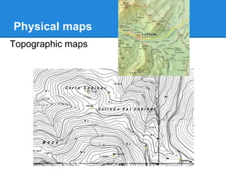
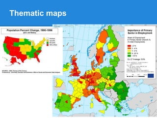
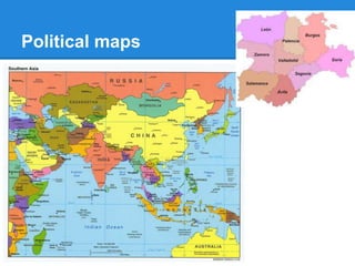
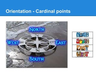
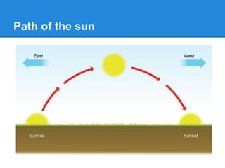
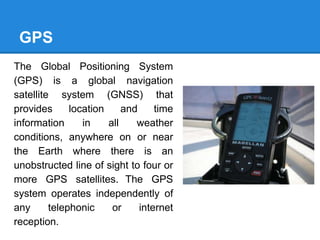
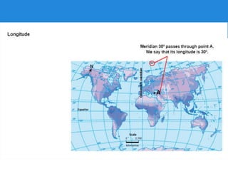
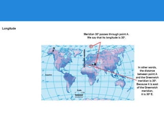
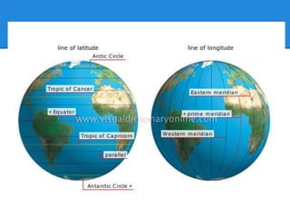
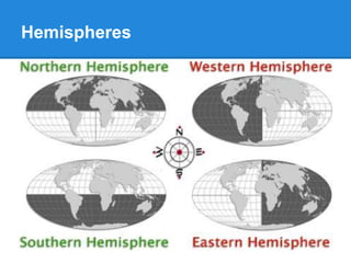
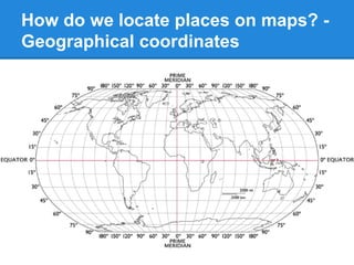
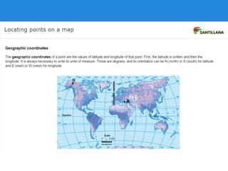
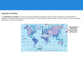
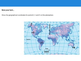
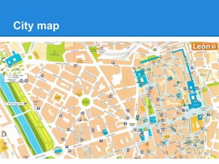
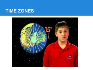
Unit 1 -
Planet
Earth
Teacher Rocío González
1º Bil
Let’s start!
Go to page 7 in your books.
Read the text on page 6… and think about the
questions in the following page.
You have 3 minutes!
Why is the Earth called "the blue planet"?
The Earth is referred to as "the blue planet" because of the
abundance of water on the planet. Over 70 percent of the
Earth's surface is comprised of water, producing a vivid blue
color when viewed from space.
Yuri Gagarin
Yuri Gagarin was a Russian
Soviet pilot and cosmonaut. He
was the first human to journey into
outer space, when his Vostok
spacecraft completed an orbit of
the Earth on 12 April 1961.
Gagarin became an international
celebrity, and was awarded many
medals and titles, including Hero
of the Soviet Union, the nation's
highest honour.
What is a satellite?
An object in an orbit is called
a satellite. A satellite can be
natural, like the Moon, or
human-made.
Artificial satellites collect
images of the Earth and
transmit information from
one point on Earth to
another. Satellite images are
important in mapping,
meteorology, environmental
conservation, military
intelligence and many other
fields.
Ptolemy’s map
The Ptolemy world map is a map of the world known to
Hellenistic society in the 2nd century. It is based on the
description contained in Ptolemy's book Geography, written
c. 150. Based on an inscription in several of the earliest
surviving manuscripts, it is traditionally credited to
Agathodaemon of Alexandria.
The continents are given as Europe, Asia, and Libya
(Africa). The World Ocean is only seen to the west. The map
distinguishes two large enclosed seas: the Mediterranean and
the Indian (Indicum Pelagus).
1- The Earth and the Solar System
THE SOLAR SYSTEM (You can click here for more info)
The Earth and the Moon
The Moon's orbit around Earth.
Watch the video
The biosphere: life on Earth
The biosphere is the ecological system in which life exists.
The outer structure of the Earth
The Earth’s surface is made up of 3 parts: atmosphere,
lithospheer and hydrosphere.
Time for activities
You can start now and you should finish
at home if time is not enough for you…
● EXERCISES 5 & 6 ON PAGE 9.
● THINK ABOUT IT, PAGE 9.
2- The movement of the Earth
Rotation and revolution
The seasons
What causes seasons?
● Exercises 1 to 5 on
page 10.
● Exercises 7 and 8 on
page 11.
● Exercise 7 on page
19.
3- How do we represent the Earth?
Main features of a map
What types of maps are there?
Physical maps
Physical maps
Topographic maps
Thematic maps
Political maps
Orientation - Cardinal points
Path of the sun
Compass
GPS
The Global Positioning System
(GPS) is a global navigation
satellite system (GNSS) that
provides location and time
information in all weather
conditions, anywhere on or near
the Earth where there is an
unobstructed line of sight to four or
more GPS satellites. The GPS
system operates independently of
any telephonic or internet
reception.
● Exercises 4 and 5 on page 13.
● Exercise 1 on page 18.
4- The geographic coordinates
Parallels and meridians
Latitude and longitude
Hemispheres
How do we locate places on maps? -
Geographical coordinates
Activities
● Practise more location while completing exercises 1 and 3
on page 15.
● Make also exercise 5 on page 18 in your notebook.
5- How do we use scale on a map?
Graphic or bar scale
How do we represent scale on a map?
Numeric or written scale
1/100 -> 1 cm on the map is 100 cm on the
ground, so it is 1 metre.
1/2000 -> 1 cm on the map is 2000 cm on the
ground (20 metres)
Activities
Practise scale use with exercises 1 and 2 on page 16-17.
City map
Use a city map
First, go to page 20 in your book and practice with the
exercises 1 and 2 in your notebook.
Then, we are doing a speaking practice with exercise 3.
TIME ZONES
Time zones
The Prime Meridian (Greenwich) is taken as reference to know the time in any place in the
world. Using it we add one hour for each time zone that is moved towards the east and we
subtract one hour for each time zone moved toward the west.
Activities
To practise about time zones, go to page 21,
and answer the questions from exercise 1.
Practise
1. El punto A se encuentra localizado próximo a la ciudad de Seattle, Estados Unidos. Si en Seattle
son las 2:00 am qué hora será en el punto B que está próximo a la ciudad de Santiago, Chile. ¿Qué
hora será en el punto C cercano a El Cairo, Egipto?
2. Por otro lado, si en El Cairo, Egipto (C) son las 7:00 pm, qué hora será en el punto D localizado en
Atyrau, Kazajistán y en el punto E localizado en Sídney, Australia. ¿Es la misma fecha en todas las
localidades?
3. Si en Atyrau, Kazajistán son la 3:00 pm, qué hora será en Seattle, Estados Unidos o qué hora será
Sídney, Australia.
4. Si en el huso horario 0 son las 4:00 am, qué hora será en Santiago, Chile.
5. Si en el huso horario +3 son las 4:00 pm, qué actividad deben estar haciendo los habitantes del
huso horario -7. ¿Se acuestan a dormir en la noche o se están levantando temprano en la mañana
para comenzar el día?

Unit 1 planet earth

  • 1.
    Unit 1 - Planet Earth TeacherRocío González 1º Bil
  • 2.
    Let’s start! Go topage 7 in your books. Read the text on page 6… and think about the questions in the following page. You have 3 minutes!
  • 3.
    Why is theEarth called "the blue planet"? The Earth is referred to as "the blue planet" because of the abundance of water on the planet. Over 70 percent of the Earth's surface is comprised of water, producing a vivid blue color when viewed from space.
  • 4.
    Yuri Gagarin Yuri Gagarinwas a Russian Soviet pilot and cosmonaut. He was the first human to journey into outer space, when his Vostok spacecraft completed an orbit of the Earth on 12 April 1961. Gagarin became an international celebrity, and was awarded many medals and titles, including Hero of the Soviet Union, the nation's highest honour.
  • 5.
    What is asatellite? An object in an orbit is called a satellite. A satellite can be natural, like the Moon, or human-made. Artificial satellites collect images of the Earth and transmit information from one point on Earth to another. Satellite images are important in mapping, meteorology, environmental conservation, military intelligence and many other fields.
  • 6.
    Ptolemy’s map The Ptolemyworld map is a map of the world known to Hellenistic society in the 2nd century. It is based on the description contained in Ptolemy's book Geography, written c. 150. Based on an inscription in several of the earliest surviving manuscripts, it is traditionally credited to Agathodaemon of Alexandria. The continents are given as Europe, Asia, and Libya (Africa). The World Ocean is only seen to the west. The map distinguishes two large enclosed seas: the Mediterranean and the Indian (Indicum Pelagus).
  • 8.
    1- The Earthand the Solar System THE SOLAR SYSTEM (You can click here for more info)
  • 9.
    The Earth andthe Moon The Moon's orbit around Earth. Watch the video
  • 10.
    The biosphere: lifeon Earth The biosphere is the ecological system in which life exists.
  • 11.
    The outer structureof the Earth The Earth’s surface is made up of 3 parts: atmosphere, lithospheer and hydrosphere.
  • 12.
    Time for activities Youcan start now and you should finish at home if time is not enough for you… ● EXERCISES 5 & 6 ON PAGE 9. ● THINK ABOUT IT, PAGE 9.
  • 13.
    2- The movementof the Earth Rotation and revolution
  • 14.
  • 16.
    ● Exercises 1to 5 on page 10. ● Exercises 7 and 8 on page 11. ● Exercise 7 on page 19.
  • 17.
    3- How dowe represent the Earth?
  • 19.
  • 20.
    What types ofmaps are there? Physical maps
  • 21.
  • 22.
  • 23.
  • 24.
  • 25.
  • 26.
  • 27.
    GPS The Global PositioningSystem (GPS) is a global navigation satellite system (GNSS) that provides location and time information in all weather conditions, anywhere on or near the Earth where there is an unobstructed line of sight to four or more GPS satellites. The GPS system operates independently of any telephonic or internet reception.
  • 28.
    ● Exercises 4and 5 on page 13. ● Exercise 1 on page 18.
  • 29.
    4- The geographiccoordinates Parallels and meridians
  • 32.
  • 40.
  • 41.
    How do welocate places on maps? - Geographical coordinates
  • 46.
    Activities ● Practise morelocation while completing exercises 1 and 3 on page 15. ● Make also exercise 5 on page 18 in your notebook.
  • 47.
    5- How dowe use scale on a map? Graphic or bar scale
  • 48.
    How do werepresent scale on a map? Numeric or written scale 1/100 -> 1 cm on the map is 100 cm on the ground, so it is 1 metre. 1/2000 -> 1 cm on the map is 2000 cm on the ground (20 metres)
  • 49.
    Activities Practise scale usewith exercises 1 and 2 on page 16-17.
  • 50.
  • 51.
    Use a citymap First, go to page 20 in your book and practice with the exercises 1 and 2 in your notebook. Then, we are doing a speaking practice with exercise 3.
  • 52.
  • 53.
    Time zones The PrimeMeridian (Greenwich) is taken as reference to know the time in any place in the world. Using it we add one hour for each time zone that is moved towards the east and we subtract one hour for each time zone moved toward the west.
  • 54.
    Activities To practise abouttime zones, go to page 21, and answer the questions from exercise 1.
  • 55.
    Practise 1. El puntoA se encuentra localizado próximo a la ciudad de Seattle, Estados Unidos. Si en Seattle son las 2:00 am qué hora será en el punto B que está próximo a la ciudad de Santiago, Chile. ¿Qué hora será en el punto C cercano a El Cairo, Egipto? 2. Por otro lado, si en El Cairo, Egipto (C) son las 7:00 pm, qué hora será en el punto D localizado en Atyrau, Kazajistán y en el punto E localizado en Sídney, Australia. ¿Es la misma fecha en todas las localidades? 3. Si en Atyrau, Kazajistán son la 3:00 pm, qué hora será en Seattle, Estados Unidos o qué hora será Sídney, Australia. 4. Si en el huso horario 0 son las 4:00 am, qué hora será en Santiago, Chile. 5. Si en el huso horario +3 son las 4:00 pm, qué actividad deben estar haciendo los habitantes del huso horario -7. ¿Se acuestan a dormir en la noche o se están levantando temprano en la mañana para comenzar el día?