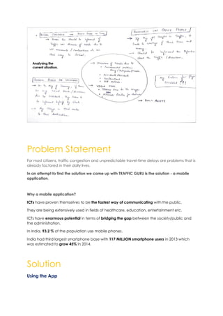
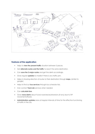
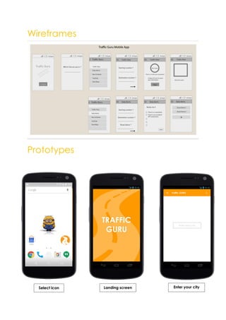
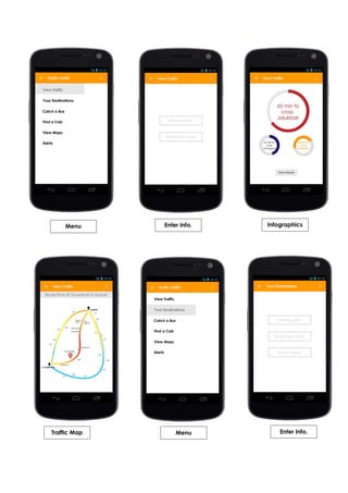
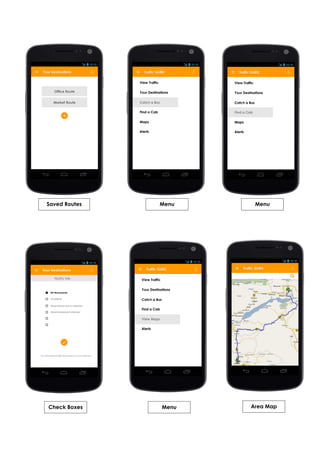
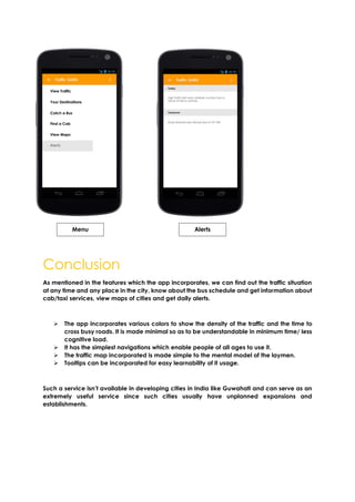
Traffic Management
Systems (TMS)
Systems Approach to Design
Pratul.Ch.Kalita, Ph.D.
B Madhuri Bhavana | Vandana Banapuram | Manchu Prudhvi | Y Manteshori Devi
The present system
Elements of the system
- Administration
- People in general
- Public Transport
- Private Transport
- Road
- Parking Facilities
- Establishments
- Safety
- Construction & Maintenance
- Disaster
The gap model of the system
Gaps among administration and other elements
GAP – 1 Parking Facilities
• Lack of Info about Parking facilities
GAP – 2 People in General
• No Civic Sense
• Unware of Traffic rules and
guidelines
• Lack of Knowledge in Law & Order
GAP – 3 Public Transport
• Maintenance of
• No Proper bus stops
GAP – 4 Private Transport
• Unauthorized Vehicles
• Increasing number of private
vehicles, due to lack of
maintenance in Public services
GAP – 5 Safety
• Disasters Predictions
• Lack of corporation between
Administration & public
GAP – 6 Public Transport & Private Transport
• Buses Height
• Health & Hygiene means of
transport
• Buses Capacity , Overload
• Vehicles maintenance
• Lack of awareness regarding stops
• Civic Sense
• Security of Passengers
• GAP – 7 Establishments
• No Proper Planning
• Unauthorized buildings
• Increase in needs in the
materialistic world
• Hygiene maintenance
• Safety & Security matters
• Parking Slots
• Lack of awareness rights &
responsibilities
GAP 8 – Private Transport
• Trust Factor , which makes increase
in private vehicles
• Increasing number of private
vehicles, due to lack of
maintenance in Public services
GAP 9 - Establishments – Construction &
Maintenance
• Linkages
• To control the traffic while
constructions on roads
• Alternate roads
• Labour maintenance
GAP 10 – Roads – Parking Facilities –
Private transport
• Narrow Roads
• Infographics regarding the parking
slots
Relationship and interdependency between all the subsystems
Focussing deep into
one Issue & Sorting out
the Problems related to
it connecting with other
elements.
Problem Statement
For most citizens, traffic congestion and unpredictable travel-time delays are problems that is
already factored in their daily lives.
In an attempt to find the solution we came up with TRAFFIC GURU is the solution - a mobile
application.
Why a mobile application?
ICTs have proven themselves to be the fastest way of communicating with the public.
They are being extensively used in fields of healthcare, education, entertainment etc.
ICTs have enormous potential in terms of bridging the gap between the society/public and
the administration.
In India, 93.2 % of the population use mobile phones.
India had third largest smartphone base with 117 MILLION smartphone users in 2013 which
was estimated to grow 45% in 2014.
Solution
Using the App
Features of the application
 Helps to view the present traffic situation between 2 places.
 Get alternate routes and the traffic to reach the same destination.
 Can save the 3 major routes and get the alerts accordingly.
 Gives regular updates to mobile if there is any traffic jam.
 Helps in showing direction of routes to their destination through maps. (similar to
google)
 Helps to find out bus services through bus schedule tab.
 Can contact Taxi/cab services when needed.
 Can calculate fare.
 Gives news/alerts about future road blocks/diversions (if any) due to VIP
movements/floods.
 Administration updates news at regular intervals of time for the effective functioning
of traffic in the city
Wireframes
Prototypes
Select icon Landing screen Enter your city
Menu Enter Info. Infographics
Traffic Map Menu Enter Info.
Saved Routes Menu Menu
Check Boxes Menu Area Map
Conclusion
As mentioned in the features which the app incorporates, we can find out the traffic situation
at any time and any place in the city, know about the bus schedule and get information about
cab/taxi services, view maps of cities and get daily alerts.
 The app incorporates various colors to show the density of the traffic and the time to
cross busy roads. It is made minimal so as to be understandable in minimum time/ less
cognitive load.
 It has the simplest navigations which enable people of all ages to use it.
 The traffic map incorporated is made simple to the mental model of the laymen.
 Tooltips can be incorporated for easy learnability of it usage.
Such a service isn’t available in developing cities in India like Guwahati and can serve as an
extremely useful service since such cities usually have unplanned expansions and
establishments.
Menu Alerts
Further work in the area
The administration of the Traffic management department of the city in the functioning and
the managing of the app can be enhanced. Processes can be designed for effective
updating of app.
Gesture or Voice based inputs for the application can be added since it should be easy to e
used while driving.
A Solution to meet the needs of
Physically Disabled people
Does the design of the public transport premises and infrastructure meet the Disability
Standards for Accessible Public Transport (DSAPT)?’
The use of directional tactile ground surface indicators (DTGSIs) must then be considered to
assist people who are blind or vision impaired to navigate the area.
• Footpath ‘shore line’ area free of obstructions promoting ease of access for people
who are blind or vision impaired.
• DTGSIs at transport interchange in wide open space provides directional assistance
• Audio Tactile Push Button located on side of signal pole pointing in the direction of
travel
_ _ _ _ _ _ _ _ _ _ _ _ _ _ _ _xxx _ _ _ _ _ _ _ _ _ _ _ _ _ _ _ _ _
120205012 | 120205014 | 120205024 | 120205047

Traffic management system in Guwahati

  • 1.
    Traffic Management Systems (TMS) SystemsApproach to Design Pratul.Ch.Kalita, Ph.D. B Madhuri Bhavana | Vandana Banapuram | Manchu Prudhvi | Y Manteshori Devi The present system Elements of the system - Administration - People in general - Public Transport - Private Transport - Road - Parking Facilities - Establishments - Safety - Construction & Maintenance - Disaster The gap model of the system
  • 2.
    Gaps among administrationand other elements GAP – 1 Parking Facilities • Lack of Info about Parking facilities GAP – 2 People in General • No Civic Sense • Unware of Traffic rules and guidelines • Lack of Knowledge in Law & Order GAP – 3 Public Transport • Maintenance of • No Proper bus stops GAP – 4 Private Transport • Unauthorized Vehicles • Increasing number of private vehicles, due to lack of maintenance in Public services GAP – 5 Safety • Disasters Predictions • Lack of corporation between Administration & public GAP – 6 Public Transport & Private Transport • Buses Height • Health & Hygiene means of transport • Buses Capacity , Overload • Vehicles maintenance • Lack of awareness regarding stops • Civic Sense • Security of Passengers • GAP – 7 Establishments • No Proper Planning • Unauthorized buildings • Increase in needs in the materialistic world • Hygiene maintenance • Safety & Security matters • Parking Slots • Lack of awareness rights & responsibilities GAP 8 – Private Transport • Trust Factor , which makes increase in private vehicles • Increasing number of private vehicles, due to lack of maintenance in Public services GAP 9 - Establishments – Construction & Maintenance • Linkages • To control the traffic while constructions on roads • Alternate roads • Labour maintenance GAP 10 – Roads – Parking Facilities – Private transport • Narrow Roads • Infographics regarding the parking slots
  • 3.
    Relationship and interdependencybetween all the subsystems Focussing deep into one Issue & Sorting out the Problems related to it connecting with other elements.
  • 4.
    Problem Statement For mostcitizens, traffic congestion and unpredictable travel-time delays are problems that is already factored in their daily lives. In an attempt to find the solution we came up with TRAFFIC GURU is the solution - a mobile application. Why a mobile application? ICTs have proven themselves to be the fastest way of communicating with the public. They are being extensively used in fields of healthcare, education, entertainment etc. ICTs have enormous potential in terms of bridging the gap between the society/public and the administration. In India, 93.2 % of the population use mobile phones. India had third largest smartphone base with 117 MILLION smartphone users in 2013 which was estimated to grow 45% in 2014. Solution Using the App
  • 5.
    Features of theapplication  Helps to view the present traffic situation between 2 places.  Get alternate routes and the traffic to reach the same destination.  Can save the 3 major routes and get the alerts accordingly.  Gives regular updates to mobile if there is any traffic jam.  Helps in showing direction of routes to their destination through maps. (similar to google)  Helps to find out bus services through bus schedule tab.  Can contact Taxi/cab services when needed.  Can calculate fare.  Gives news/alerts about future road blocks/diversions (if any) due to VIP movements/floods.  Administration updates news at regular intervals of time for the effective functioning of traffic in the city
  • 6.
  • 7.
    Menu Enter Info.Infographics Traffic Map Menu Enter Info.
  • 8.
    Saved Routes MenuMenu Check Boxes Menu Area Map
  • 9.
    Conclusion As mentioned inthe features which the app incorporates, we can find out the traffic situation at any time and any place in the city, know about the bus schedule and get information about cab/taxi services, view maps of cities and get daily alerts.  The app incorporates various colors to show the density of the traffic and the time to cross busy roads. It is made minimal so as to be understandable in minimum time/ less cognitive load.  It has the simplest navigations which enable people of all ages to use it.  The traffic map incorporated is made simple to the mental model of the laymen.  Tooltips can be incorporated for easy learnability of it usage. Such a service isn’t available in developing cities in India like Guwahati and can serve as an extremely useful service since such cities usually have unplanned expansions and establishments. Menu Alerts
  • 10.
    Further work inthe area The administration of the Traffic management department of the city in the functioning and the managing of the app can be enhanced. Processes can be designed for effective updating of app. Gesture or Voice based inputs for the application can be added since it should be easy to e used while driving. A Solution to meet the needs of Physically Disabled people Does the design of the public transport premises and infrastructure meet the Disability Standards for Accessible Public Transport (DSAPT)?’ The use of directional tactile ground surface indicators (DTGSIs) must then be considered to assist people who are blind or vision impaired to navigate the area. • Footpath ‘shore line’ area free of obstructions promoting ease of access for people who are blind or vision impaired. • DTGSIs at transport interchange in wide open space provides directional assistance • Audio Tactile Push Button located on side of signal pole pointing in the direction of travel _ _ _ _ _ _ _ _ _ _ _ _ _ _ _ _xxx _ _ _ _ _ _ _ _ _ _ _ _ _ _ _ _ _ 120205012 | 120205014 | 120205024 | 120205047