The Terrestrial Goes Extraterrestrial
•
1 like•48 views

National Geographic Channel team discovers the benefits of imaging station technology when investigating alleged UFO sightings for the network's "Chasing UFOs" series, by Don Talend, brand storytelling, content management, and content strategy expert. Geospatial technology industry

Recommended
More Related Content
Similar to The Terrestrial Goes Extraterrestrial
Similar to The Terrestrial Goes Extraterrestrial (20)
More from Don Talend
More from Don Talend (20)
Recently uploaded
Recently uploaded (20)
The Terrestrial Goes Extraterrestrial
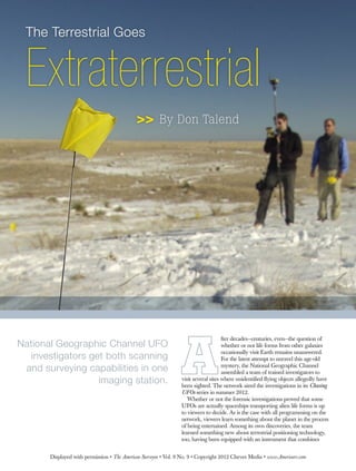
- 1. Extraterrestrial The Terrestrial Goes >> By Don Talend fter decades—centuries, even—the question of whether or not life forms from other galaxies occasionally visit Earth remains unanswered. For the latest attempt to unravel this age-old mystery, the National Geographic Channel assembled a team of trained investigators to visit several sites where unidentified flying objects allegedly have been sighted. The network aired the investigations in its Chasing UFOs series in summer 2012. Whether or not the forensic investigations proved that some UFOs are actually spaceships transporting alien life forms is up to viewers to decide. As is the case with all programming on the network, viewers learn something about the planet in the process of being entertained. Among its own discoveries, the team learned something new about terrestrial positioning technology, too, having been equipped with an instrument that combines National Geographic Channel UFO investigators get both scanning and surveying capabilities in one imaging station. Displayed with permission • The American Surveyor • Vol. 9 No. 9 • Copyright 2012 Cheves Media • www.Amerisurv.com
- 2. advanced imaging with high-accuracy surveying capabilities. In fall 2011, the program’s producers approached Topcon Positioning Systems about letting the team use a basic survey- ing instrument such as an auto level when mapping out investigation sites. Upon finding out that the team needed both scanning and surveying capabil- ity—and mobility—for some episodes, Scott Langbein, Topcon’s director of product marketing, recommended the IS-3 imaging station. One of the investigators—geologist, radiation scientist, field explorer and left-brain analytical thinker/UFO skeptic Ben McGee—had a fair amount of land surveying experience and was tasked with those responsibilities during the investigations. He was joined by technol- ogy/reconnaissance specialist Erin Ryder and documentarian/UFO believer James Fox. “When the production company asked me what I needed to do a survey, I said I needed standard survey equip- ment, ideally something that would be all-in-one,” McGee said. “I said I need something I can range with, collect GPS coordinates with, and something I can measure elevations with and anything more than that—like panoramic imag- ery—would be great.” The IS-3 basically combines the power, accuracy and speed of a total station with the auto-scanning capabilities of a laser scanner. It features dual digital imaging cameras that show a real-time color image on the touch LCD display. A grid feature locks preset points to their exact position on the image, even when the instrument is rotated. The instrument has the longest scanning range in the industry at up to 6,500 feet. It provides industry-best accuracy, automatic scanning speed and on-board features designed to provide quicker scanning definition, faster image collection and real-time preview of scanned data. It can utilize Topcon ImageMaster software that produces “photography with dimension,” an alternative to laser scanning. The IS-3 has WLAN capability and can be controlled remotely. One instrument, multiple functions McGee had done land surveying in the process of doing hydrology work for the Southern Nevada Water Authority in the past, using a total station to precisely measure the depth of streams for water-rights issues, for example. He expected to use several instruments for his geospatial work on Chasing UFOs. “The alternative would have been using multiple pieces of older equip- ment, none of which would have been as capable together with respect to the IS-3,” he said. The imaging station that McGee wound up using bridged a gap that exists between geospatial coordinates and actual imagery—and a gap between the field and the office, Langbein noted. “The typical survey instrument documents individual points and you end up with a list of individual points or positions. Here you get the same data, but it also has built-in cameras that you can use to take a photo record and docu- ment the scene by photo. So when you get back to your office and there is more area that you weren’t able to measure out there, you can do it later. “Sometimes Ben would collect a certain amount of data, a certain number of measurements. When they got back to the office and heard testimonial stories from other people, he could go back and look at a 360-degree panoramic view of the site using the ImageMaster software and see individual points that he measured.” Big tools were needed for a big job, Langbein added. “When we started talking about what equipment to choose, I equated the team to forensics investigators. Forensics teams like to use instruments like the IS-3 when they go out and investigate a car crash and they have a limited amount of time to clear the lanes of traffic. They were basically dealing in forensics.” When filming began in late 2011, McGee needed training, and quickly. In the middle of the week in early December, Langbein was informed that an episode in New Mexico was scheduled to be filmed the following Friday. He quickly booked a flight, arrived in Roswell on Thursday night and introduced the system to the production team at the hotel. The next day they drove about two hours out of Roswell and then hiked a fair distance to the Roswell investigation site and completed the training after the crew began filming. “I have to commend Scott on his work because he went the extra mile to create a PowerPoint desktop instruction for me to quickly digest,” McGee recalled. “The IS-3 operating system was straightforward, the functionality was straightforward. In his “I said I need something I can range with, collect GPS coordinates with, and some- thing I can measure elevations with and anything more than that—like panoramic imagery—would be great.” —Ben McGee, Chasing UFOs investigator Displayed with permission • The American Surveyor • Vol. 9 No. 9 • Copyright 2012 Cheves Media • www.Amerisurv.com
- 3. desktop instructions, Scott did not have to say click this, then that—he could speak more generally and I could figure out exactly what to do.” Unearthing New Mexico evidence In New Mexico, the team investigated both a video showing a UFO crash in the 1990s and forensic evidence of crash debris and the military’s collection of evidence from the Roswell site following the famous alleged 1947 spaceship crash. McGee remained unconvinced that the alleged crash video was anything extra- terrestrial, despite claims to the contrary by and experts is that the object was a disk and not a missile. On the forensic side, the team determined conclusively that humans left some debris behind at the site at some point, even though they did not find any artifacts that were undoubtedly extraterrestrial. By far the most famous UFO conspiracy theory holds that the U.S. Air Force collected physical evidence of a 1947 alien spaceship crash near Roswell, N.M., stored and studied the evidence at its Area 51 base in Nevada and covered it all up. Frank Kimbler, a geologist who has sought evidence of a UFO crash at the Roswell site for the International UFO Museum and Research Center in Roswell, led the team to the alleged crash site. McGee used the IS-3 to survey the site, with Langbein staying onsite to provide technical support when necessary. They tied the position of the IS rover pole to some existing control structures on the site to allow precise loca- tion of any artifacts that the team might find on the survey grid. They shot about 12,000 points in the process of establishing contours on the site. One key find was a piece of rebar driven into the ground at the top of the hill. McGee fell back on his geology training to note that debris does not get washed up to the top of a hill; humans must have put it there. More importantly, “People who use Topcon equipment might recognize that as a likely survey benchmark,” McGee said. “To me, that was exciting because we were surveying something that somebody else found interesting enough to survey and it did not look like it lined up with the USGS survey. It didn’t prove anything, but what a lucky strike right in our grid to find someone else’s grid,” he said, though noting later in a NatGeo TV blog entry that there was no way to prove that it served this purpose. A particularly intriguing find just beyond McGee’s grid was a button, ostensibly from an Air Force uniform. The presence of the button, later confirmed as having been issued by the Air Force in 1949—a full two years after the alleged crash—does nonetheless prove that military personnel were probably present at the site, although it is possible that a civilian could have been wearing a surplus Air Force jacket. Soil radiation testing in Texas In an episode that aired before Roswell, the team visited Dublin and Stephensville, Texas to investigate a report in the June 20, 1891 Dublin Progress newspaper about a meteoric explosion that was said to have deposited pieces of metal near an old grist mill. The explosion reportedly was preceded by white lights in the sky. The team looked for metal fragments and ash deposits and conducted a radiation survey to detect if a nuclear reaction—indicating the presence of a spacecraft—occurred nearby. McGee used a prism and the IS-3 to identify a survey area so that the team could identify prime locations for soil sampling. Ryder canvassed the area with a radiation exposure meter to monitor radiation levels. The 1-meter-by-1-meter survey grid was smaller than that in Roswell, measuring about 20 meters in depth and about 10 meters in width. “A lot of people alleged that these sorts of events are radiological, so we were testing against a hypothesis to see if there was any activation of the soil or deposits of radioactive material,” McGee said. “We also looked for evidence of anything like ash, old burn horizons or anything like that, in addition to the high concentrations of metals. None of the soil samples, artifacts we found or radio- logical conditions indicated that anything extraordinary happened there.” McGee recalled that a storm blew in and forced him to survey the site in the dark. The IS-3 allowed him to do it quickly. The survey was comprehensive and refer- ences soil samples and piece of aluminum debris—which is likely from a farm implement—in case a return to the site is ever necessary, he said. “The IS-3 held up under wet conditions and it was extremely easy to read in the dark,” McGee added. Investigating alleged Arizona abduction The third episode in which the team utilized the IS-3 brought it to the Phoenix area. There, the team investi- gated a 1997 sighting of strange lights in the sky by numerous residents of the metro area, and an alleged abduction. McGee, an investigator on the National Geographic Channel Chasing UFOs series, sets up a survey grid using the Topcon IS-3 imaging station at night. The choice to use the IS-3 just prior to filming made the night training necessary. Displayed with permission • The American Surveyor • Vol. 9 No. 9 • Copyright 2012 Cheves Media • www.Amerisurv.com
- 4. An experiment involving a night skydiving team pretty much disproved the theory that eyewitnesses mistook this activity for alien spacecraft, while McGee’s speculations about aircraft formations keeps this incident—like most UFO sightings—a mystery. The forensic investigation of the alleged abduction did not strongly indicate that this incident occurred. The investigators and Travis Walton, a logger, visited the site of off of a logging road about three hours northeast of Phoenix in Siltgreaves National Forest near Snowflake, AZ, where he claims he was struck by a beam of energy, abducted by aliens flying a massive spaceship and spent five days aboard back in 1976. The team again focused on detecting radiation at the site in order to form a possible hypothesis supporting such an incident. The team took core samples of a tree located near the center of the alleged abduction zone and it appeared that the tree underwent accelerated growth for about 15 years after 1976. McGee then constructed the alleged abduction zone by imaging a 360-degree panorama using the IS-3 and marking tree locations with ImageMaster. Later, he compared cores from other trees in the vicinity of the first cored tree using his survey as well as a previous site survey, located the other trees in the panorama, and concluded that not all of the trees experienced the same level of accelerated growth. As was the case throughout the investigations, McGee made a case for something other than spaceship radiation as the cause of accelerated growth in the first cored tree. He acknowledged that he is not a biologist and possesses even less botany knowledge but said that hydrol- ogy, i.e., the presence of a snowpack in the years after 1976, is a possible explanation for accelerated tree growth. “But it was something to test against, anyway, so the IS-3 helped us get out there and capture the site really quickly and anchor our survey points,” McGee recalled. Langbein added that, even though he did not visit the Arizona site, McGee sent him the images comprising the panorama to keep him apprised of his forensic work there. Additional documentation, flexibility The investigations that employed the IS-3 may not have conclusively proved anything in the extraterrestrial realm, but they proved that surveying and scanning can be done in much less time than with separate instrumentation. “It’s a way of using a new piece of technology to get multiple layers of documentation,” Langbein said of the imaging station. “In the history of survey and construction, you used to use a field book, paper and pen and you would write down your angles and distances. Then we moved into data collectors that might show a small map view. Then people started carrying cameras and they would measure things and then take a picture of them. “This is for anybody who needs to do what they’ve done in the past—it does everything that a total station does—but would like the additional documentation through photo records. Cameras are built into the instrument, so everything that is measured is also photographed and referenced in the data set. If you don’t know for sure if you needed to measure something in the field, you can go back and look that data a year from now. You don’t have to go back out to the jobsite because you have a complete documented scene.” To McGee, increased flexibility was a huge benefit. “Essentially, the IS-3 presented a suite of potential options and let me choose how best to survey a site, whether it made more sense to create a reference corner and go to grid and then mark individual points, flag the grid out in the field, or image the whole site and simply range to an item of interest,” he said. “The flexibility it afforded us to conduct these investigations was just a treat for me.” Don Talend, Write Results Inc., West Dundee, IL, is a print and e-communi- cations content developer specializing in covering technology and innovation. McGee (left), an investigator on the National Geographic Channel Chasing UFOs series, sets up a survey grid using the Topcon IS-3 imaging station near Roswell, N.M., while Scott Langbein, Topcon’s director of product marketing, provides technical assistance. Displayed with permission • The American Surveyor • Vol. 9 No. 9 • Copyright 2012 Cheves Media • www.Amerisurv.com