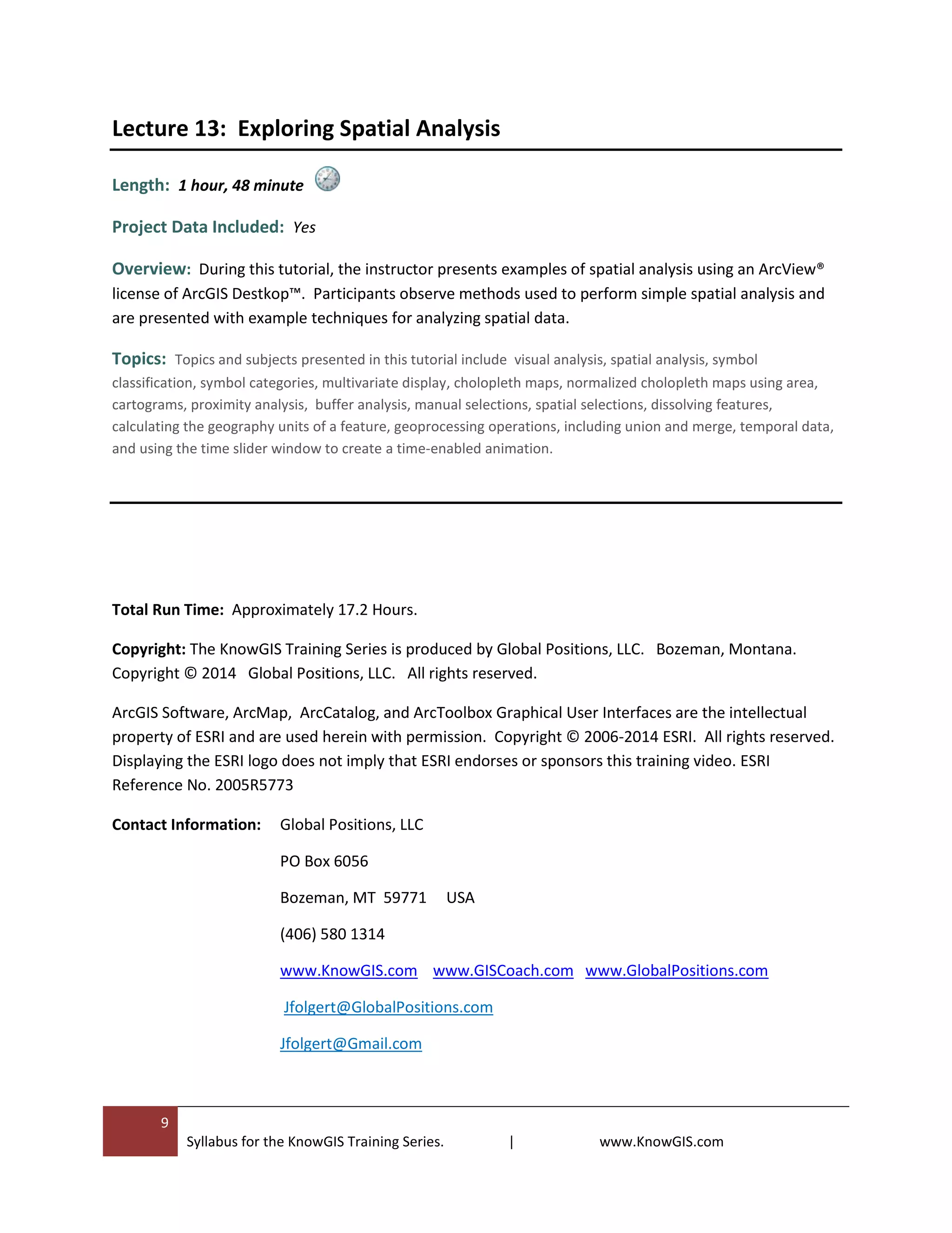
1
Syllabus for the KnowGIS Training Series. | www.KnowGIS.com
Course Syllabus
Professional ArcGIS Desktop Training Course.
KnowGIS 10 Training Series. Instructor: Jere Folgert
Effective Learning Strategies
Introduction to Geographic Information Systems
Finding a Hidden Treasure using ArcGIS Desktop
What is ArcGIS ?
Exploring ArcCatalog
Creating a File Geodatabase (Part 1 of 2)
Creating a File Geodatabase (Part 2 of 2)
Exploring ArcMap
Cartography and Making Maps
Editing and Creating Data with ArcMap
Exploring Tables, Graphs, and Reports.
Image Registration and Spatial Transformation
Exploring Simple Spatial Analysis
Lecture 1:
Lecture 2:
Lecture 3:
Lecture 4 :
Lecture 5:
Lecture 6:
Lecture 7:
Lecture 8:
Lecture 9:
Lecture 10:
Lecture 11:
Lecture 12:
Lecture 13:
The KnowGIS training series
includes approximately 17 hours of
material.
www.KnowGIS.com
jfolgert@GlobalPositions.com
2
Syllabus for the KnowGIS Training Series. | www.KnowGIS.com
Syllabus - KnowGIS 10 Training Course
Learning GIS and ArcGIS Desktop v10.x | Instructor: Jere P. Folgert
www.KnowGIS.com
Course Description and Overview: The KnowGIS training series is an intensive,
innovative, video-based course that provides participants with an understanding of the essential
principles and elements of Geographic Information Systems (GIS) and ArcGIS Desktop™ software. The
course includes over sixteen hours of material, twelve primary tutorials, and relevant project data. This
course provides the groundwork for becoming a productive ArcGIS Desktop ™ user.
Participants learn how to use ArcMap™, ArcCatalog™, and ArcToolbox™, and explore how these
applications work in concert to organize, display, analyze, and present geographic information assets.
This course covers GIS concepts as well as specific components and tools in the ArcView® license of
ArcGIS Desktop™. Participants learn how to organize spatial data, query a GIS database, perform
selections, edit and modify spatial data, update attribute tables, perform calculations using the field
calculator, design and develop a File Geodatabase, register and rectify raster images, transform vector
data, project spatial data, create maps and charts, generate reports, and explore spatial analysis.
Participants learn by watching and doing.
Instructor: The course is taught by Jere P. Folgert. Mr. Jere Folgert has over twenty-one years of
GIS experience, has a Master’s of Science degree in GIS from the University of Edinburgh, UK, became an
ESRI Certified instructor in 1999, and is the recipient of the National Science Foundation (NSF) Award:
Small Business Innovation Research (SBIR) Award.
Audience: This course presents introductory and intermediate material and is designed for
participants and professionals who are new to ArcGIS Desktop™ or to geographic information systems.
However, it also meets the needs of a refresher course in GIS and ArcGIS Desktop™, and as a course for
upgrading ArcGIS Desktop™ skills.
3
Syllabus for the KnowGIS Training Series. | www.KnowGIS.com
Goals: The goals of this course are to expose participants to the practice and use of ArcGIS Desktop™,
introduce participants to the field of GIS, and help participants develop the conceptual and
methodological skills necessary for working with and interrogating spatial data.
The goals of this course are as follows:
 To facilitate a participant’s learning about GIS and ArcGIS Desktop™.
 To help a participant develop skills in thinking about geographic information and applying that
knowledge to projects and research activities.
 To familiarize the participant with the practical and logistical issues involved in using a ArcGIS
Desktop™.
 To familiarize the participant with various GIS related tasks, including the visualization of spatial
features and attributes, querying of spatial features using interactive methods and logical
expressions, selection of spatial features using geography and attributes, and the organization of
geographic information assets.
 To help the participant develop skills to design a Geodatabase through the use of logical models.
 To facilitate a participant’s learning about editing spatial data and attribute data.
 To help a participant develop skills in associating tabular data by means of joins and relates.
 To assist a participant in developing proficiency and skill in designing and producing cartographic
products, graphs, and reports.
 To provide instruction on performing image registration using raster data and to provide
instruction on adjusting vector data.
 To familiarize the participant with the practical and logistical issues involved in exploring spatial
data by means of spatial analysis.
Lecture 1: Effective Learning Strategies
Length: 13 Minutes
Project Data Included: No
Overview: This lecture provides suggestions and strategies that have the potential to heighten student
engagement and ownership in the learning process. The instructor provides techniques and strategies
for learning new software applications, provides strategies for mastering concepts of GIS software and
acquiring technical skills.
4
Syllabus for the KnowGIS Training Series. | www.KnowGIS.com
Lecture 2: Introduction Geographic Information Systems (GIS)
Length: 1 hour, 40 minutes
Project Data Included: Yes
Overview: This lecture provides an introduction to GIS and presents concepts related to geographic
information science. This lecture balances core principles of GIS with real-world examples. This lecture
should be particularly useful for participants interested in learning about geographic information
science, spatial referencing systems, map projections, and feature-attribute associations. Participants
are not expected to have prior experience with GIS.
Topics: Topics and subjects presented in this tutorial include spatial referencing systems, map projections,
feature-attribute associations, thematic layers, geographic information assets, example uses of GIS, a brief history
of GIS, datums, geoids, ellipsoids, the Cartesian coordinate system, projecting data using ArcGIS Desktop™, vector
data (points, lines, polylines, and polygons), the Geodatabase, ESRI Shapefiles, spatial transformations,
geoprocessing tools (dissolve, buffer, union, and intersect), and spatial joins.
Lecture 3: Finding a Hidden Treasure using ArcGIS Desktop
Length: 1 hour, 14 minutes
Project Data Included: Yes
Overview: This tutorial provides participants with a challenge: Locate a hidden treasure using ArcGIS
Desktop™ and abstruse clues. This fast paced tutorial supports generating new spatial data, data
display activities, data exploration, analytical decision making, data conversion, planning, and spatial
analysis.
Topics: Topics and subjects presented in this tutorial include Georeferencing, ASCII text files, Event Layers, the
Geodatabase, the cut polygon tool, the intersect tool, selecting features by attribute and by location, the measure
tool, measuring offsets, digitizing, using direction and measurement systems, including the polar and north
azimuth system.
5
Syllabus for the KnowGIS Training Series. | www.KnowGIS.com
Lecture 4: What is ArcGIS?
Length: 37 minutes
Project Data Included: No
Overview: This lecture provides a overview of ArcGIS™. The instructor provides an summary of
ArcGIS™, ArcGIS Desktop™, ArcGIS On-Line™, and ArcGIS mobile™. This modest lecture should be
particularly useful for participants who are new to ArcGIS™.
Lecture 5: Exploring ArcCatalog
Length: 1 hour, 14 minutes
Project Data: Yes
Overview: This tutorial provides participants with a comprehensive overview of ArcCatalog™. The
instructor presents and describes the components of the interface and provides instruction on how to
use ArcCatalog™ to organize, browse, define, and discover spatial data. The instructor presents and
explores information on the Catalog Tree, Folder Connections, ArcInfo™ exchange files, creating a search
index, ArcGIS Help, ArcGIS Online™, and metadata tools.
Lecture 6: Creating a File Geodatabase (Part 1 of 2)
Length: 1 hour, 7 minutes
Project Data Included: Yes
Overview: The goal of this tutorial is to create a Geodatabase using an existing repository of
geographic information assets. Participants observe how ArcCatalog™ is used to pre-organize spatial
assets, project or re-project spatial data to a new spatial referencing system, define the spatial
referencing system of an asset, and create feature classes and feature datasets.
6
Syllabus for the KnowGIS Training Series. | www.KnowGIS.com
Lecture 7: Creating a File Geodatabase (Part 2 of 2)
Length: 1 hour, 33 minutes
Project Data Included: Yes
Overview: The focus of this tutorial is to design and implement a file Geodatabase. The instructor
begins this lecture with a discussion on modeling the real world and provides examples of how, through
the use of models, participants can represent aspects of the real world in a GIS. This is considered an
intermediate-level lecture and presents information on domains and subtypes.
Topics: Topics and subjects presented in this tutorial include the file Geodatabase, database relates, models,
tables, keys, conceptual and physical data models, problem solving, Geodatabase design, the simple data loader,
subtypes, and domains.
Lecture 8: Exploring ArcMap
Length: 1 hour, 45 minutes
Project Data Included: Yes
Overview: The goal of this tutorial is to explore ArcMap™. Participants are presented with the
components of the ArcMap™ interface, including the table of contents, tool bars, the data view, and
layout view. The instructor provides a description of the tools and components that comprise the tool
bars, provides a description of keyboard short-cuts, and presents tricks and tips for navigating though
spatial data.
Topics: Topics and subjects presented in this tutorial include data frames, spatial referencing systems, the data
view and layout view, selecting features, establishing and using a hyperlink, using the Goto XY command, the table
of contents options, group layers, map scale, extent indicators, the effects toolbar, transparency, map packages,
map layers, layer packages, and tips and tricks.
7
Syllabus for the KnowGIS Training Series. | www.KnowGIS.com
Lecture 9: Cartography and Making Maps
Length: 1 hour, 48 minutes
Project Data Included: Yes
Overview: The purpose of this lecture is to provide an introduction to cartography and making maps
using ArcGIS Desktop™. The lectures cover fundamental cartographic concepts, geographic information
presentation principles, as well as map-making techniques. The instructor presents participants with a
basis for making intelligent decisions concerning the interpretation and creation of maps and presents
material on the principles of map design.
Topics: Topics and subjects presented in this tutorial include cartographic design, simplification, generalization,
map symbols, map audience, characteristics of a good map, font styles, point size, perception of color and light,
visual clarity, visual contrast, balance, visual hierarchy, spatial book marks, clipping a data frame, graduated
symbols, symbol categories using unique values, labels, inserting and adjusting map elements, draft mode, color
ramps, the legend wizard, the expression box, exporting maps, map templates, rotating a data frame, and the
layout toolbar.
Lecture 10: Editing and Creating Data with ArcMap
Length: 1 hour, 32 minutes
Project Data Included: Yes
Overview: The objective of this tutorial is to explore the ArcMap™ editing environment. The
instructor presents information on the intuitive, sketch-based editing environment and how to create
and edit feature geometry and attributes. Participants observe how to inventory and map spatial
features, and learn how to use ArcMap’s editing environment.
Topics: Topics and subjects presented in this tutorial include editing, digitizing, the create features dialog box,
feature templates, construction tools, template properties, the edit vertices tool bar, the trace tool, subtypes, the
auto complete polygon tool, the freehand drawing tool, stream digitizing mode, the attribute window, the cut
polygon tool, the switch selection tool bar, reshaping features, creating Bezier curves, the move to tool, the field
calculator, populating fields, and the snapping environment.
8
Syllabus for the KnowGIS Training Series. | www.KnowGIS.com
Lecture 11: Exploring Tables, Graphs, and Reports.
Length: 1 hour, 35 minutes
Project Data Included: Yes
Overview: During this tutorial participants explore table properties, define new tables, add new fields
to tables, populate fields with attributes, and generate graphs and reports from tables.
Topics: Topics and subjects presented in this tutorial include graphs, reports, switching selected sets, generating
statistics, working with Microsoft Excel™ files and ASCII format, table joins, cardinality, one-to-one relationships,
one-to-many relationships, many-to-many relationships, many-to-one relationships, relating tables, rearranging
multiple fields at one time, using the field calculator with numbers, text strings, and dates, calculating the
geometry of a feature, generating graphs, spatial selections, table join, the report generator, the report wizard, the
document file (.rdf), the report layout file (.rlf), and tips and keyboard short cuts.
Lecture 12: Image Registration and Spatial Transformation
Length: 1 hour, 1 minute
Project Data Included: Yes
Overview: This tutorial provides instruction on how to register and rectify raster images and how to
transform vector data. The instructor presents information and examples on how to add control links,
view residual errors, and select a transformation method and displays the results of different applied
transformation methods.
Topics: Topics and subjects presented in this tutorial include image registration, georeferencing, affine
transformations, displacement links, residual error, viewing the root mean square (RMS) error, resampling
techniques, image distortion, orthorectification, the rational polynomial coefficient (RPC) file, spatial adjustment,
and the adjustment preview window.
9
Syllabus for the KnowGIS Training Series. | www.KnowGIS.com
Lecture 13: Exploring Spatial Analysis
Length: 1 hour, 48 minute
Project Data Included: Yes
Overview: During this tutorial, the instructor presents examples of spatial analysis using an ArcView®
license of ArcGIS Destkop™. Participants observe methods used to perform simple spatial analysis and
are presented with example techniques for analyzing spatial data.
Topics: Topics and subjects presented in this tutorial include visual analysis, spatial analysis, symbol
classification, symbol categories, multivariate display, cholopleth maps, normalized cholopleth maps using area,
cartograms, proximity analysis, buffer analysis, manual selections, spatial selections, dissolving features,
calculating the geography units of a feature, geoprocessing operations, including union and merge, temporal data,
and using the time slider window to create a time-enabled animation.
Total Run Time: Approximately 17.2 Hours.
Copyright: The KnowGIS Training Series is produced by Global Positions, LLC. Bozeman, Montana.
Copyright © 2014 Global Positions, LLC. All rights reserved.
ArcGIS Software, ArcMap, ArcCatalog, and ArcToolbox Graphical User Interfaces are the intellectual
property of ESRI and are used herein with permission. Copyright © 2006-2014 ESRI. All rights reserved.
Displaying the ESRI logo does not imply that ESRI endorses or sponsors this training video. ESRI
Reference No. 2005R5773
Contact Information: Global Positions, LLC
PO Box 6056
Bozeman, MT 59771 USA
(406) 580 1314
www.KnowGIS.com www.GISCoach.com www.GlobalPositions.com
Jfolgert@GlobalPositions.com
Jfolgert@Gmail.com

Syllabus 14.1

  • 1.
    1 Syllabus for theKnowGIS Training Series. | www.KnowGIS.com Course Syllabus Professional ArcGIS Desktop Training Course. KnowGIS 10 Training Series. Instructor: Jere Folgert Effective Learning Strategies Introduction to Geographic Information Systems Finding a Hidden Treasure using ArcGIS Desktop What is ArcGIS ? Exploring ArcCatalog Creating a File Geodatabase (Part 1 of 2) Creating a File Geodatabase (Part 2 of 2) Exploring ArcMap Cartography and Making Maps Editing and Creating Data with ArcMap Exploring Tables, Graphs, and Reports. Image Registration and Spatial Transformation Exploring Simple Spatial Analysis Lecture 1: Lecture 2: Lecture 3: Lecture 4 : Lecture 5: Lecture 6: Lecture 7: Lecture 8: Lecture 9: Lecture 10: Lecture 11: Lecture 12: Lecture 13: The KnowGIS training series includes approximately 17 hours of material. www.KnowGIS.com jfolgert@GlobalPositions.com
  • 2.
    2 Syllabus for theKnowGIS Training Series. | www.KnowGIS.com Syllabus - KnowGIS 10 Training Course Learning GIS and ArcGIS Desktop v10.x | Instructor: Jere P. Folgert www.KnowGIS.com Course Description and Overview: The KnowGIS training series is an intensive, innovative, video-based course that provides participants with an understanding of the essential principles and elements of Geographic Information Systems (GIS) and ArcGIS Desktop™ software. The course includes over sixteen hours of material, twelve primary tutorials, and relevant project data. This course provides the groundwork for becoming a productive ArcGIS Desktop ™ user. Participants learn how to use ArcMap™, ArcCatalog™, and ArcToolbox™, and explore how these applications work in concert to organize, display, analyze, and present geographic information assets. This course covers GIS concepts as well as specific components and tools in the ArcView® license of ArcGIS Desktop™. Participants learn how to organize spatial data, query a GIS database, perform selections, edit and modify spatial data, update attribute tables, perform calculations using the field calculator, design and develop a File Geodatabase, register and rectify raster images, transform vector data, project spatial data, create maps and charts, generate reports, and explore spatial analysis. Participants learn by watching and doing. Instructor: The course is taught by Jere P. Folgert. Mr. Jere Folgert has over twenty-one years of GIS experience, has a Master’s of Science degree in GIS from the University of Edinburgh, UK, became an ESRI Certified instructor in 1999, and is the recipient of the National Science Foundation (NSF) Award: Small Business Innovation Research (SBIR) Award. Audience: This course presents introductory and intermediate material and is designed for participants and professionals who are new to ArcGIS Desktop™ or to geographic information systems. However, it also meets the needs of a refresher course in GIS and ArcGIS Desktop™, and as a course for upgrading ArcGIS Desktop™ skills.
  • 3.
    3 Syllabus for theKnowGIS Training Series. | www.KnowGIS.com Goals: The goals of this course are to expose participants to the practice and use of ArcGIS Desktop™, introduce participants to the field of GIS, and help participants develop the conceptual and methodological skills necessary for working with and interrogating spatial data. The goals of this course are as follows:  To facilitate a participant’s learning about GIS and ArcGIS Desktop™.  To help a participant develop skills in thinking about geographic information and applying that knowledge to projects and research activities.  To familiarize the participant with the practical and logistical issues involved in using a ArcGIS Desktop™.  To familiarize the participant with various GIS related tasks, including the visualization of spatial features and attributes, querying of spatial features using interactive methods and logical expressions, selection of spatial features using geography and attributes, and the organization of geographic information assets.  To help the participant develop skills to design a Geodatabase through the use of logical models.  To facilitate a participant’s learning about editing spatial data and attribute data.  To help a participant develop skills in associating tabular data by means of joins and relates.  To assist a participant in developing proficiency and skill in designing and producing cartographic products, graphs, and reports.  To provide instruction on performing image registration using raster data and to provide instruction on adjusting vector data.  To familiarize the participant with the practical and logistical issues involved in exploring spatial data by means of spatial analysis. Lecture 1: Effective Learning Strategies Length: 13 Minutes Project Data Included: No Overview: This lecture provides suggestions and strategies that have the potential to heighten student engagement and ownership in the learning process. The instructor provides techniques and strategies for learning new software applications, provides strategies for mastering concepts of GIS software and acquiring technical skills.
  • 4.
    4 Syllabus for theKnowGIS Training Series. | www.KnowGIS.com Lecture 2: Introduction Geographic Information Systems (GIS) Length: 1 hour, 40 minutes Project Data Included: Yes Overview: This lecture provides an introduction to GIS and presents concepts related to geographic information science. This lecture balances core principles of GIS with real-world examples. This lecture should be particularly useful for participants interested in learning about geographic information science, spatial referencing systems, map projections, and feature-attribute associations. Participants are not expected to have prior experience with GIS. Topics: Topics and subjects presented in this tutorial include spatial referencing systems, map projections, feature-attribute associations, thematic layers, geographic information assets, example uses of GIS, a brief history of GIS, datums, geoids, ellipsoids, the Cartesian coordinate system, projecting data using ArcGIS Desktop™, vector data (points, lines, polylines, and polygons), the Geodatabase, ESRI Shapefiles, spatial transformations, geoprocessing tools (dissolve, buffer, union, and intersect), and spatial joins. Lecture 3: Finding a Hidden Treasure using ArcGIS Desktop Length: 1 hour, 14 minutes Project Data Included: Yes Overview: This tutorial provides participants with a challenge: Locate a hidden treasure using ArcGIS Desktop™ and abstruse clues. This fast paced tutorial supports generating new spatial data, data display activities, data exploration, analytical decision making, data conversion, planning, and spatial analysis. Topics: Topics and subjects presented in this tutorial include Georeferencing, ASCII text files, Event Layers, the Geodatabase, the cut polygon tool, the intersect tool, selecting features by attribute and by location, the measure tool, measuring offsets, digitizing, using direction and measurement systems, including the polar and north azimuth system.
  • 5.
    5 Syllabus for theKnowGIS Training Series. | www.KnowGIS.com Lecture 4: What is ArcGIS? Length: 37 minutes Project Data Included: No Overview: This lecture provides a overview of ArcGIS™. The instructor provides an summary of ArcGIS™, ArcGIS Desktop™, ArcGIS On-Line™, and ArcGIS mobile™. This modest lecture should be particularly useful for participants who are new to ArcGIS™. Lecture 5: Exploring ArcCatalog Length: 1 hour, 14 minutes Project Data: Yes Overview: This tutorial provides participants with a comprehensive overview of ArcCatalog™. The instructor presents and describes the components of the interface and provides instruction on how to use ArcCatalog™ to organize, browse, define, and discover spatial data. The instructor presents and explores information on the Catalog Tree, Folder Connections, ArcInfo™ exchange files, creating a search index, ArcGIS Help, ArcGIS Online™, and metadata tools. Lecture 6: Creating a File Geodatabase (Part 1 of 2) Length: 1 hour, 7 minutes Project Data Included: Yes Overview: The goal of this tutorial is to create a Geodatabase using an existing repository of geographic information assets. Participants observe how ArcCatalog™ is used to pre-organize spatial assets, project or re-project spatial data to a new spatial referencing system, define the spatial referencing system of an asset, and create feature classes and feature datasets.
  • 6.
    6 Syllabus for theKnowGIS Training Series. | www.KnowGIS.com Lecture 7: Creating a File Geodatabase (Part 2 of 2) Length: 1 hour, 33 minutes Project Data Included: Yes Overview: The focus of this tutorial is to design and implement a file Geodatabase. The instructor begins this lecture with a discussion on modeling the real world and provides examples of how, through the use of models, participants can represent aspects of the real world in a GIS. This is considered an intermediate-level lecture and presents information on domains and subtypes. Topics: Topics and subjects presented in this tutorial include the file Geodatabase, database relates, models, tables, keys, conceptual and physical data models, problem solving, Geodatabase design, the simple data loader, subtypes, and domains. Lecture 8: Exploring ArcMap Length: 1 hour, 45 minutes Project Data Included: Yes Overview: The goal of this tutorial is to explore ArcMap™. Participants are presented with the components of the ArcMap™ interface, including the table of contents, tool bars, the data view, and layout view. The instructor provides a description of the tools and components that comprise the tool bars, provides a description of keyboard short-cuts, and presents tricks and tips for navigating though spatial data. Topics: Topics and subjects presented in this tutorial include data frames, spatial referencing systems, the data view and layout view, selecting features, establishing and using a hyperlink, using the Goto XY command, the table of contents options, group layers, map scale, extent indicators, the effects toolbar, transparency, map packages, map layers, layer packages, and tips and tricks.
  • 7.
    7 Syllabus for theKnowGIS Training Series. | www.KnowGIS.com Lecture 9: Cartography and Making Maps Length: 1 hour, 48 minutes Project Data Included: Yes Overview: The purpose of this lecture is to provide an introduction to cartography and making maps using ArcGIS Desktop™. The lectures cover fundamental cartographic concepts, geographic information presentation principles, as well as map-making techniques. The instructor presents participants with a basis for making intelligent decisions concerning the interpretation and creation of maps and presents material on the principles of map design. Topics: Topics and subjects presented in this tutorial include cartographic design, simplification, generalization, map symbols, map audience, characteristics of a good map, font styles, point size, perception of color and light, visual clarity, visual contrast, balance, visual hierarchy, spatial book marks, clipping a data frame, graduated symbols, symbol categories using unique values, labels, inserting and adjusting map elements, draft mode, color ramps, the legend wizard, the expression box, exporting maps, map templates, rotating a data frame, and the layout toolbar. Lecture 10: Editing and Creating Data with ArcMap Length: 1 hour, 32 minutes Project Data Included: Yes Overview: The objective of this tutorial is to explore the ArcMap™ editing environment. The instructor presents information on the intuitive, sketch-based editing environment and how to create and edit feature geometry and attributes. Participants observe how to inventory and map spatial features, and learn how to use ArcMap’s editing environment. Topics: Topics and subjects presented in this tutorial include editing, digitizing, the create features dialog box, feature templates, construction tools, template properties, the edit vertices tool bar, the trace tool, subtypes, the auto complete polygon tool, the freehand drawing tool, stream digitizing mode, the attribute window, the cut polygon tool, the switch selection tool bar, reshaping features, creating Bezier curves, the move to tool, the field calculator, populating fields, and the snapping environment.
  • 8.
    8 Syllabus for theKnowGIS Training Series. | www.KnowGIS.com Lecture 11: Exploring Tables, Graphs, and Reports. Length: 1 hour, 35 minutes Project Data Included: Yes Overview: During this tutorial participants explore table properties, define new tables, add new fields to tables, populate fields with attributes, and generate graphs and reports from tables. Topics: Topics and subjects presented in this tutorial include graphs, reports, switching selected sets, generating statistics, working with Microsoft Excel™ files and ASCII format, table joins, cardinality, one-to-one relationships, one-to-many relationships, many-to-many relationships, many-to-one relationships, relating tables, rearranging multiple fields at one time, using the field calculator with numbers, text strings, and dates, calculating the geometry of a feature, generating graphs, spatial selections, table join, the report generator, the report wizard, the document file (.rdf), the report layout file (.rlf), and tips and keyboard short cuts. Lecture 12: Image Registration and Spatial Transformation Length: 1 hour, 1 minute Project Data Included: Yes Overview: This tutorial provides instruction on how to register and rectify raster images and how to transform vector data. The instructor presents information and examples on how to add control links, view residual errors, and select a transformation method and displays the results of different applied transformation methods. Topics: Topics and subjects presented in this tutorial include image registration, georeferencing, affine transformations, displacement links, residual error, viewing the root mean square (RMS) error, resampling techniques, image distortion, orthorectification, the rational polynomial coefficient (RPC) file, spatial adjustment, and the adjustment preview window.
  • 9.
    9 Syllabus for theKnowGIS Training Series. | www.KnowGIS.com Lecture 13: Exploring Spatial Analysis Length: 1 hour, 48 minute Project Data Included: Yes Overview: During this tutorial, the instructor presents examples of spatial analysis using an ArcView® license of ArcGIS Destkop™. Participants observe methods used to perform simple spatial analysis and are presented with example techniques for analyzing spatial data. Topics: Topics and subjects presented in this tutorial include visual analysis, spatial analysis, symbol classification, symbol categories, multivariate display, cholopleth maps, normalized cholopleth maps using area, cartograms, proximity analysis, buffer analysis, manual selections, spatial selections, dissolving features, calculating the geography units of a feature, geoprocessing operations, including union and merge, temporal data, and using the time slider window to create a time-enabled animation. Total Run Time: Approximately 17.2 Hours. Copyright: The KnowGIS Training Series is produced by Global Positions, LLC. Bozeman, Montana. Copyright © 2014 Global Positions, LLC. All rights reserved. ArcGIS Software, ArcMap, ArcCatalog, and ArcToolbox Graphical User Interfaces are the intellectual property of ESRI and are used herein with permission. Copyright © 2006-2014 ESRI. All rights reserved. Displaying the ESRI logo does not imply that ESRI endorses or sponsors this training video. ESRI Reference No. 2005R5773 Contact Information: Global Positions, LLC PO Box 6056 Bozeman, MT 59771 USA (406) 580 1314 www.KnowGIS.com www.GISCoach.com www.GlobalPositions.com Jfolgert@GlobalPositions.com Jfolgert@Gmail.com