мапа безпеки Єгипту
•
0 likes•979 views

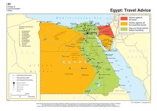
This map shows the geography and administrative divisions of Egypt. It outlines the country's borders and location in Northeast Africa, bordered by Libya to the west, Sudan to the south, the Red Sea to the east, and the Mediterranean Sea to the north. Key geographical features include the Red Sea, Gulf of Suez, Gulf of Aqaba, Sinai Peninsula, Western Desert, and Nile River. Egypt is divided administratively into 27 governorates or provinces, numbered on the map. Major cities shown include Cairo, Alexandria, and Aswan.
Recommended

Recommended
More Related Content
More from Майдан Закордонних Справ
More from Майдан Закордонних Справ (20)
Recently uploaded
Recently uploaded (20)
мапа безпеки Єгипту
- 1. Jabal Mūsá (Mount Sinai) L i b y a n (Eastern D esert ) Aìõahr£’ashSharqÀ yah M unkhafaé al Qa&&£rah (Qattara Depression) D e s e r t (Western Desert) Aì õahr£’ al GharbÀyah R e d S e a Gulfof Sue z GulfofAqaba M e d i t e r r a n e a n S e a Lake Nasser KhalÀj al ‘Arab NahranNÀl(Nile) E G Y P T JOR DAN ISRAEL WEST BANK GAZA Al Maks al BaèrÀ Mvî Qaìr al Far£firah Al BawÀîÀ Al ô£rrah Sanhvr SÀwah SÀdÀ Barr£nÀAs SallvmUmm S£‘d Rafaè ú£b£ Al ôamm£m Ra’s Gh£rib Dhahab St Catherine’s Monastery Ra’s Muèammad Nuwaybi‘ (Nuweiba) Sharm ash Shaykh (Sharm el Sheikh) Abv ZanÀmah An Nakhl Al Quìayr Bvr Saf£jah (Safaga) Marsá ‘Alam Kawm Umbv (Kom Ombo) Bi’r Shalatayn Hala’ib Idfv (Edfu) Armant úahî£ Manfalvî MallawÀ AkhmÀm Abv Sunbul (Abu Simbel) AL WØD¥ AL JAD¥D MAúRºH 1 2 3 4 5 6 8 9 10 11 7 AL J¥ZAH AL QØHIRAH AL MINYØ ASYºú SºHØJ AL UQõUR QINØ BAN¥ SUWAYF AL FAYYºM AS SUWAYS JANºB S¥NØ’ SHAMØL S¥NØ’ AL BAôR AL AôMAR ASWØN Al IskandarÀyah (Alexandria) Damanhvr Marsá Maîrvè ShibÀn al Kawm Al JÀzah (Giza) Al Fayyvm Al Miny£ Asyvî S™h£j (Sohag) Al Kh£rijah Qin£ Al Uqìur (Luxor) Al Ghurdaqah (Hurghada) Asw£n BanÀ Suwayf Aî úvr As Suways (Suez) úanî£ Banh£ Az Zaq£zÀq Al Ism£’ÀlÀyah Al Manìvrah Dumy£î (Damietta) Al ‘Ar•sh Bvr Sa’Àd (Port Said)Kafr ash Shaykh ‘AMMØN AL QØHIRAH (CAIRO) Ad DaqahlÀyah Al Buèayrah Al GharbÀyah Al IskandarÀyah Al Ism£’ÀlÀyah Minvf•yah Al QalyvbÀyah Ash SharqÀyah Bvr Sa’Àd Dumy£î Kafr ash Shaykh Numbered administrative divisions: 1. 2. 3. 4. 5. 6. 7. 8. 9. 10. 11. Hala’ib Triangle Egypt: Travel Advice FCO 329 Edition 17 (August 2015) Users should note that this map has been designed for briefing purposes only and it should not be used for determining the precise location of places or features. This map should not be considered an authority on the delimination of international boundaries or on the spelling of place and feature names. Maps produced for KTD are not to be taken as necessarily representing the views of the UK government on boundaries or political status © Crown Copyright 2015 National Capital Administrative Boundary Administrative Centre Major Road Disputed Boundary International Boundary Other Town Railway 3000 150 kilometers 0 150miles Advise against all but essential travel See our travel advice before travelling Advise against all travel