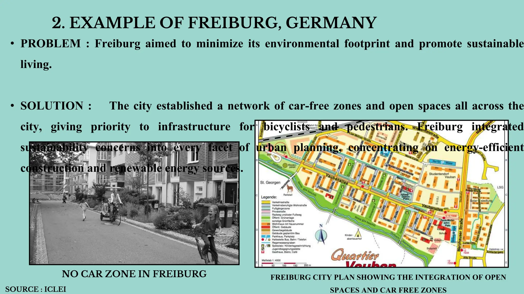
UNIT 3.1 - SPATIAL INTEGRATION
MODULE 208 : POPULATION AND REGIONAL DEVELOPMENT
SPATIAL INTEGRATION
INTRODUCTION : Spatial integration refers to the integration of diverse
planning-related entities such as land uses, planning organizations and
stakeholders. It expresses the potential for and level of interaction inside and
between sectors, as well as a willingness to cooperate.
For example- Consider the amount of connection between transportation networks
at various geographical sizes. It can be used as a tool to develop effective spatial
planning policies.
• Thus interactions and willingness to cooperate between people and areas have to
be central to successful spatial integration.
• Resolutions to problems could be found by integrating policies of one region with
the other region.
• For example, transport problems of CNCR get resolved only through interaction and
cooperation among the states of Delhi, U.P, Haryana and Rajasthan.
• Because of the fragmentation and variety of governing structures and organizations,
there is an urgent need to address the issue of policy and development plan
integration, as well as the integration of local-level institutions.
• NEED FOR SPATIAL INTEGRATION IN REGIONAL DEVELOPMENT
• OPTIMUM RESOURCE UTLISATION INCREASING EFFICIENCY OF PLANNING : Inefficient use of resources
might result from fragmented development patterns. For example, dispersed industrial zones located distant from population
centers lead to increased transportation costs and logistical challenges. According to a research by Louw et al. (2003) on "The
Concept of Integration in Spatial Planning," spatial integration places a strong emphasis on a comprehensive
strategy.Strategic placement of activities, such as processing facilities close to farms, is encouraged in order to reduce transit
requirements and maximize resource utilization.
• PROMOTING EQUAL DEVELOPMENT : Development often gravitates towards urban centers, neglecting rural areas.
This creates a cycle of decline in rural regions, with limited access to infrastructure, services, and economic opportunities. As
argued by Wilkansky (2009) in "From Regional Planning to Spatial Planning," a shift towards spatial planning, which
incorporates spatial considerations, is crucial to address these disparities .Spatial integration aims to spread development
opportunities across the region, ensuring rural areas are not left behind.
KEY ASPECTS OF SPATIAL INTEGRATION IN REGIONAL DEVELOPMENT
Inter-relationships: Different land uses (residential, commercial, industrial) and activities
(agriculture, manufacturing, tourism) shouldn't exist in isolation. Spatial integration aims to create a
cohesive system where these elements support and benefit from each other. For example, locating
agricultural processing plants near farms can reduce transportation costs and improve efficiency.
Balanced development: Spatial integration seeks to avoid concentrating development solely in
urban centers while neglecting rural areas. It encourages spreading development opportunities across
the region, ensuring all areas have access to essential services and infrastructure.
Infrastructure: Transportation networks (roads, railways), communication systems, and utilities
(electricity, water) are crucial for spatial integration. They connect different parts of the region,
INDIA’S SMART CITY MISSION
• One interesting case study of spatial integration in regional development is India's Smart Cities Mission (SCM). The
mission was initiated in 2015 with the objective of creating a network of 100 cities throughout India, emphasizing
sustainable development, enhanced quality of life, and core infrastructure. But attaining successful spatial integration
inside these cities and the surrounding areas is crucial to the mission's success.
GOALS OF INIDA’S SMART CITY MISSION :
• Develop core infrastructure (water, electricity, waste management)
• Create a sustainable and citizen-friendly environment
• Improve quality of life for all residents
• Promote economic growth and innovation
• Ensure efficient use of resources
HOW DIFFERENT CITIES AROUND THE WORLD INCORPORATED
SPATIAL INTEGRATION IN THEIR REGION’S DEVELOPMENT
1. EXAMPLE OF MEDELLIN, COLOUMBIA
• PROBLEM : Widespread informal communities that were
cut off from the official city have long been a problem for
Medellin.
• SOLUTION : In order to improve access to employment
opportunities, educational opportunities, and basic
amenities, the city built a cable car system that connected
these villages to the main urban area. These towns also
included green spaces and public areas, which promoted SOURCE : WORLD
2. EXAMPLE OF FREIBURG, GERMANY
• PROBLEM : Freiburg aimed to minimize its environmental footprint and promote sustainable
living.
• SOLUTION : The city established a network of car-free zones and open spaces all across the
city, giving priority to infrastructure for bicyclists and pedestrians. Freiburg integrated
sustainability concerns into every facet of urban planning, concentrating on energy-efficient
construction and renewable energy sources.
NO CAR ZONE IN FREIBURG FREIBURG CITY PLAN SHOWING THE INTEGRATION OF OPEN
SPACES AND CAR FREE ZONES
SOURCE : ICLEI
3. EXAMPLE OF BHUBANESHWAR, ODISHA
• PROBLEM :Traffic congestion and the need for a more sustainable transportation system are issues
in Bhubaneswar.
• SOLUTION : In certain regions, the city is testing out TOD ideas. This entails creating mixed-use
areas close to public transportation hubs that house, employ, and provide facilities to encourage
people to walk, cycle, or take public transportation to work every day.
• The BTC is the city's first TOD initiative and smart building project, and is part of the Bhubaneswar Smart City Proposal
(SCP). The BTC's TOD strategy includes a corridor-wise TOD strategy, a transit detailed project report, non-motorized
transportation infrastructure, and TOD station areas. The BTC also includes a pedestrianized environment and cycling
tracks, which will help promote non-motorized transport (NMT)
SOURCE : SMART CITY MISSION BHUBANESHWAR
4. EXAMPLE OF AHMEDABAD, GUJRAT
• PROBLEM : Like many other Indian towns, Ahmedabad struggles with separated industrial
sectors and pre-existing urban sprawl.
• SOLUTION : The creation of growth corridors is emphasized in the city's 2005 development plan.
These corridors facilitate economic integration and the effective flow of people and goods between
Ahmedabad and the neighboring industrial districts.
AHMEDBAD MASTER PLAN
DHOLERA GROWTH CORRIDOOR
• CHALLENGES IN SUCCESSFUL SPATIAL INTEGRATION :
Although spatial integration has many advantages for regional development, there are obstacles involved
in putting it into practice. Here are several significant obstacles, with examples:
1. CO-ORDINATION AND GOVERNANCE :
Diverse agencies handling various facets of development within fragmented governance frameworks
might impede cooperation and erect administrative obstacles. For instance, in India, municipalities are
often in charge of urban planning, but independent state organizations are in charge of rural
development. Implementing regional plans that take into account both urban and rural areas may be
challenging due to this lack of cooperation.
2. COMPETEING/ CLASHING INTERESTS :
Priorities that conflict may exist among various stakeholders in a given region. Goals for environmental
preservation may conflict with industrial development, and infrastructure projects may force
communities to relocate. For Example : While a proposed highway project linking two cities in a region
3. LACK OF FINANCIAL RESOURCES :
Significant financial resources are frequently needed for large-scale spatial integration projects, but
these
resources may not always be easily accessible, particularly in developing nations. Example: It costs a lot
to build a new public transportation system that connects a city to its rural hinterlands and involves
significant investments in rolling stock, infrastructure, and operating expenses. It could be difficult for
cities to get the money needed for these kinds of projects.
4. PUBLIC PARTICIPATION :
Spatial integration initiatives can sometimes lead to gentrification and displacement of existing
communities if not planned inclusively. Ensuring public participation and addressing concerns is
crucial. Example: Revitalizing a neglected downtown area might attract new businesses and residents,
but it could also lead to rising rents and force out low-income residents who lived there previously.
CONCLUSION
The idea of spatial integration has proven to be effective in attaining
balanced and sustainable development across regions. It explores the
connections between a region's many components, including its
infrastructure, population, environment, and economic activity, in
addition to its physical features. Spatial integration addresses some
of the most important issues that regions are currently facing by
promoting cooperation and strategic planning.

SPATIAL INTEGRATION IN REGIONAL DEVELOPMENT pptx

  • 1.
    UNIT 3.1 -SPATIAL INTEGRATION MODULE 208 : POPULATION AND REGIONAL DEVELOPMENT
  • 2.
    SPATIAL INTEGRATION INTRODUCTION :Spatial integration refers to the integration of diverse planning-related entities such as land uses, planning organizations and stakeholders. It expresses the potential for and level of interaction inside and between sectors, as well as a willingness to cooperate. For example- Consider the amount of connection between transportation networks at various geographical sizes. It can be used as a tool to develop effective spatial planning policies.
  • 3.
    • Thus interactionsand willingness to cooperate between people and areas have to be central to successful spatial integration. • Resolutions to problems could be found by integrating policies of one region with the other region. • For example, transport problems of CNCR get resolved only through interaction and cooperation among the states of Delhi, U.P, Haryana and Rajasthan. • Because of the fragmentation and variety of governing structures and organizations, there is an urgent need to address the issue of policy and development plan integration, as well as the integration of local-level institutions.
  • 4.
    • NEED FORSPATIAL INTEGRATION IN REGIONAL DEVELOPMENT • OPTIMUM RESOURCE UTLISATION INCREASING EFFICIENCY OF PLANNING : Inefficient use of resources might result from fragmented development patterns. For example, dispersed industrial zones located distant from population centers lead to increased transportation costs and logistical challenges. According to a research by Louw et al. (2003) on "The Concept of Integration in Spatial Planning," spatial integration places a strong emphasis on a comprehensive strategy.Strategic placement of activities, such as processing facilities close to farms, is encouraged in order to reduce transit requirements and maximize resource utilization. • PROMOTING EQUAL DEVELOPMENT : Development often gravitates towards urban centers, neglecting rural areas. This creates a cycle of decline in rural regions, with limited access to infrastructure, services, and economic opportunities. As argued by Wilkansky (2009) in "From Regional Planning to Spatial Planning," a shift towards spatial planning, which incorporates spatial considerations, is crucial to address these disparities .Spatial integration aims to spread development opportunities across the region, ensuring rural areas are not left behind.
  • 5.
    KEY ASPECTS OFSPATIAL INTEGRATION IN REGIONAL DEVELOPMENT Inter-relationships: Different land uses (residential, commercial, industrial) and activities (agriculture, manufacturing, tourism) shouldn't exist in isolation. Spatial integration aims to create a cohesive system where these elements support and benefit from each other. For example, locating agricultural processing plants near farms can reduce transportation costs and improve efficiency. Balanced development: Spatial integration seeks to avoid concentrating development solely in urban centers while neglecting rural areas. It encourages spreading development opportunities across the region, ensuring all areas have access to essential services and infrastructure. Infrastructure: Transportation networks (roads, railways), communication systems, and utilities (electricity, water) are crucial for spatial integration. They connect different parts of the region,
  • 6.
    INDIA’S SMART CITYMISSION • One interesting case study of spatial integration in regional development is India's Smart Cities Mission (SCM). The mission was initiated in 2015 with the objective of creating a network of 100 cities throughout India, emphasizing sustainable development, enhanced quality of life, and core infrastructure. But attaining successful spatial integration inside these cities and the surrounding areas is crucial to the mission's success. GOALS OF INIDA’S SMART CITY MISSION : • Develop core infrastructure (water, electricity, waste management) • Create a sustainable and citizen-friendly environment • Improve quality of life for all residents • Promote economic growth and innovation • Ensure efficient use of resources
  • 7.
    HOW DIFFERENT CITIESAROUND THE WORLD INCORPORATED SPATIAL INTEGRATION IN THEIR REGION’S DEVELOPMENT 1. EXAMPLE OF MEDELLIN, COLOUMBIA • PROBLEM : Widespread informal communities that were cut off from the official city have long been a problem for Medellin. • SOLUTION : In order to improve access to employment opportunities, educational opportunities, and basic amenities, the city built a cable car system that connected these villages to the main urban area. These towns also included green spaces and public areas, which promoted SOURCE : WORLD
  • 8.
    2. EXAMPLE OFFREIBURG, GERMANY • PROBLEM : Freiburg aimed to minimize its environmental footprint and promote sustainable living. • SOLUTION : The city established a network of car-free zones and open spaces all across the city, giving priority to infrastructure for bicyclists and pedestrians. Freiburg integrated sustainability concerns into every facet of urban planning, concentrating on energy-efficient construction and renewable energy sources. NO CAR ZONE IN FREIBURG FREIBURG CITY PLAN SHOWING THE INTEGRATION OF OPEN SPACES AND CAR FREE ZONES SOURCE : ICLEI
  • 9.
    3. EXAMPLE OFBHUBANESHWAR, ODISHA • PROBLEM :Traffic congestion and the need for a more sustainable transportation system are issues in Bhubaneswar. • SOLUTION : In certain regions, the city is testing out TOD ideas. This entails creating mixed-use areas close to public transportation hubs that house, employ, and provide facilities to encourage people to walk, cycle, or take public transportation to work every day. • The BTC is the city's first TOD initiative and smart building project, and is part of the Bhubaneswar Smart City Proposal (SCP). The BTC's TOD strategy includes a corridor-wise TOD strategy, a transit detailed project report, non-motorized transportation infrastructure, and TOD station areas. The BTC also includes a pedestrianized environment and cycling tracks, which will help promote non-motorized transport (NMT) SOURCE : SMART CITY MISSION BHUBANESHWAR
  • 10.
    4. EXAMPLE OFAHMEDABAD, GUJRAT • PROBLEM : Like many other Indian towns, Ahmedabad struggles with separated industrial sectors and pre-existing urban sprawl. • SOLUTION : The creation of growth corridors is emphasized in the city's 2005 development plan. These corridors facilitate economic integration and the effective flow of people and goods between Ahmedabad and the neighboring industrial districts. AHMEDBAD MASTER PLAN DHOLERA GROWTH CORRIDOOR
  • 11.
    • CHALLENGES INSUCCESSFUL SPATIAL INTEGRATION : Although spatial integration has many advantages for regional development, there are obstacles involved in putting it into practice. Here are several significant obstacles, with examples: 1. CO-ORDINATION AND GOVERNANCE : Diverse agencies handling various facets of development within fragmented governance frameworks might impede cooperation and erect administrative obstacles. For instance, in India, municipalities are often in charge of urban planning, but independent state organizations are in charge of rural development. Implementing regional plans that take into account both urban and rural areas may be challenging due to this lack of cooperation. 2. COMPETEING/ CLASHING INTERESTS : Priorities that conflict may exist among various stakeholders in a given region. Goals for environmental preservation may conflict with industrial development, and infrastructure projects may force communities to relocate. For Example : While a proposed highway project linking two cities in a region
  • 12.
    3. LACK OFFINANCIAL RESOURCES : Significant financial resources are frequently needed for large-scale spatial integration projects, but these resources may not always be easily accessible, particularly in developing nations. Example: It costs a lot to build a new public transportation system that connects a city to its rural hinterlands and involves significant investments in rolling stock, infrastructure, and operating expenses. It could be difficult for cities to get the money needed for these kinds of projects. 4. PUBLIC PARTICIPATION : Spatial integration initiatives can sometimes lead to gentrification and displacement of existing communities if not planned inclusively. Ensuring public participation and addressing concerns is crucial. Example: Revitalizing a neglected downtown area might attract new businesses and residents, but it could also lead to rising rents and force out low-income residents who lived there previously.
  • 13.
    CONCLUSION The idea ofspatial integration has proven to be effective in attaining balanced and sustainable development across regions. It explores the connections between a region's many components, including its infrastructure, population, environment, and economic activity, in addition to its physical features. Spatial integration addresses some of the most important issues that regions are currently facing by promoting cooperation and strategic planning.