Download as PPSX, PPTX


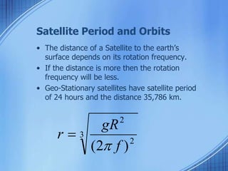
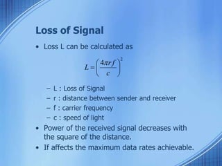
![Satellite Period and Orbits
10 20 30 40 x106 m
24
20
16
12
8
4
radius
satellite
velocity [ x1000 km/h] period [h]
synchronous distance
35,786 km](https://image.slidesharecdn.com/satellitesystems-141205211424-conversion-gate01/85/Satellite-systems-5-320.jpg)


The document provides an overview of satellite systems, including the types of orbits (geostationary, low Earth, medium Earth, and highly elliptical), satellite mechanics, and communication parameters such as elevation angle and signal loss. It addresses the advantages and disadvantages of different satellite types, highlighting factors such as latency, footprint, coverage, and signal attenuation. The information also covers the design considerations for satellite communication links and the necessity of multiple satellites for reliable global coverage.


![[Pycon 2015] 오늘 당장 딥러닝 실험하기 제출용](https://cdn.slidesharecdn.com/ss_thumbnails/pycon2015-150913033231-lva1-app6892-thumbnail.jpg?width=640&height=640&fit=bounds)

![[모두의연구소] 쫄지말자딥러닝](https://cdn.slidesharecdn.com/ss_thumbnails/20160528-160529034614-thumbnail.jpg?width=640&height=640&fit=bounds)


![Satellite communications[1]](https://cdn.slidesharecdn.com/ss_thumbnails/satellitecommunications1-130416091107-phpapp01-thumbnail.jpg?width=640&height=640&fit=bounds)


