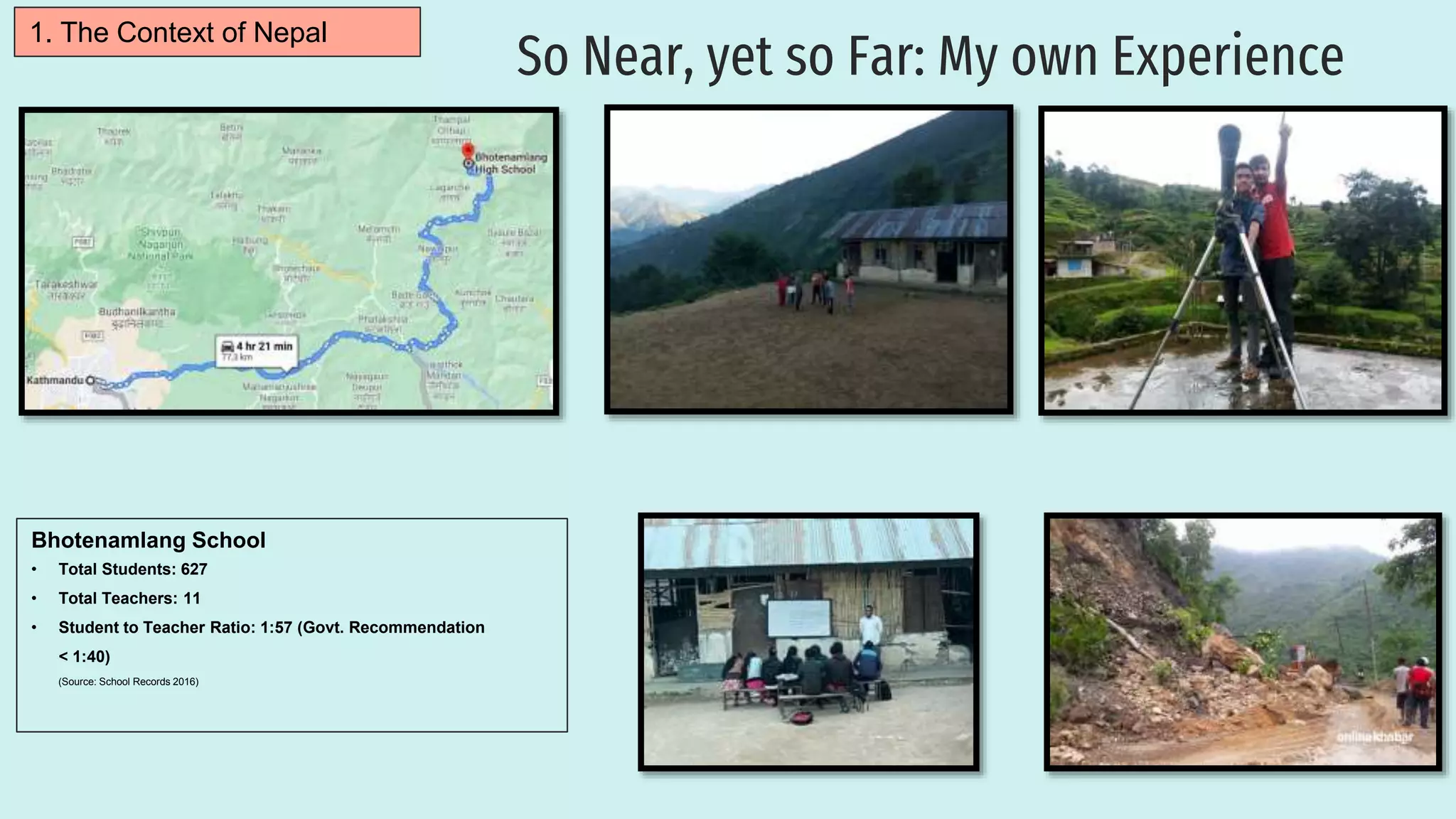
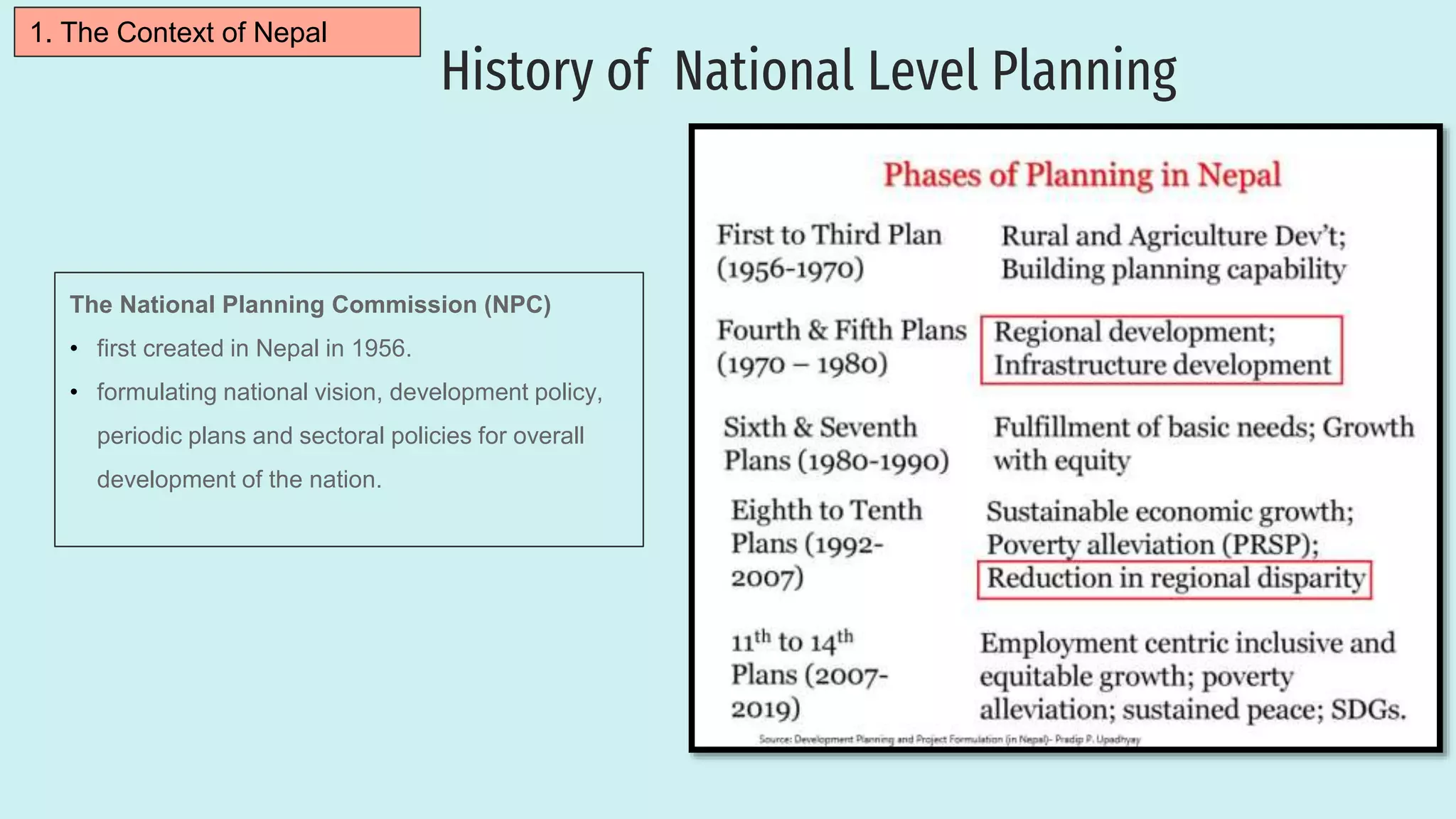
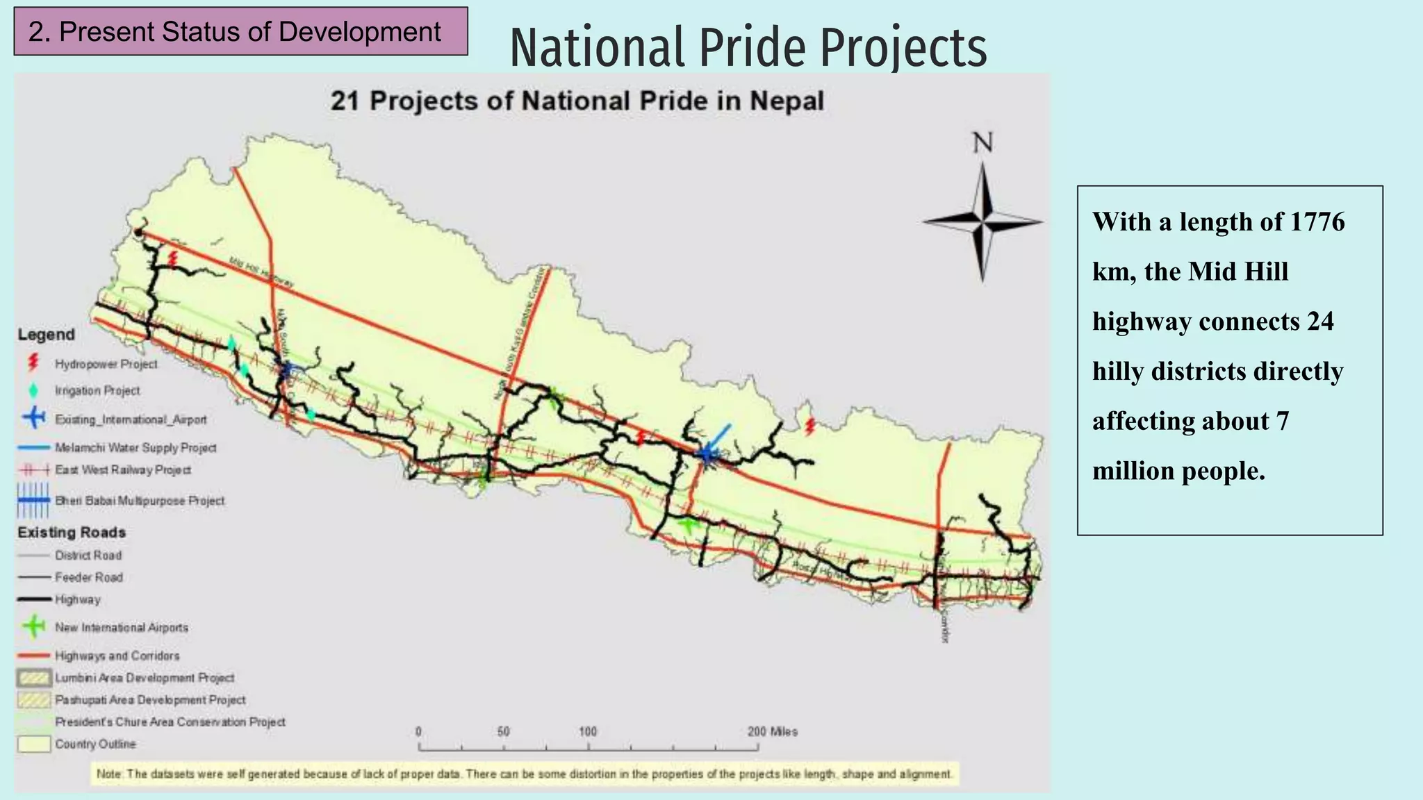
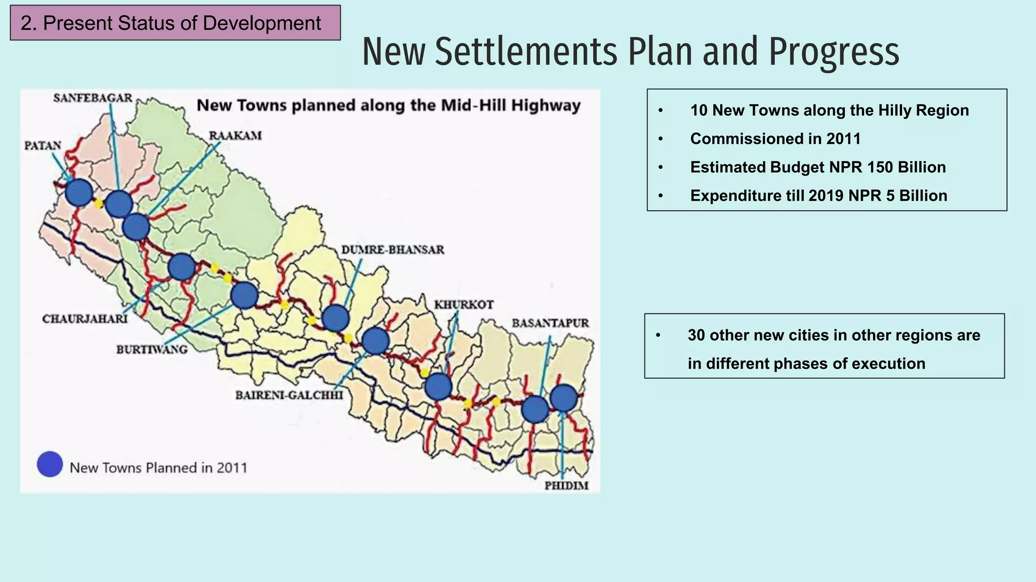
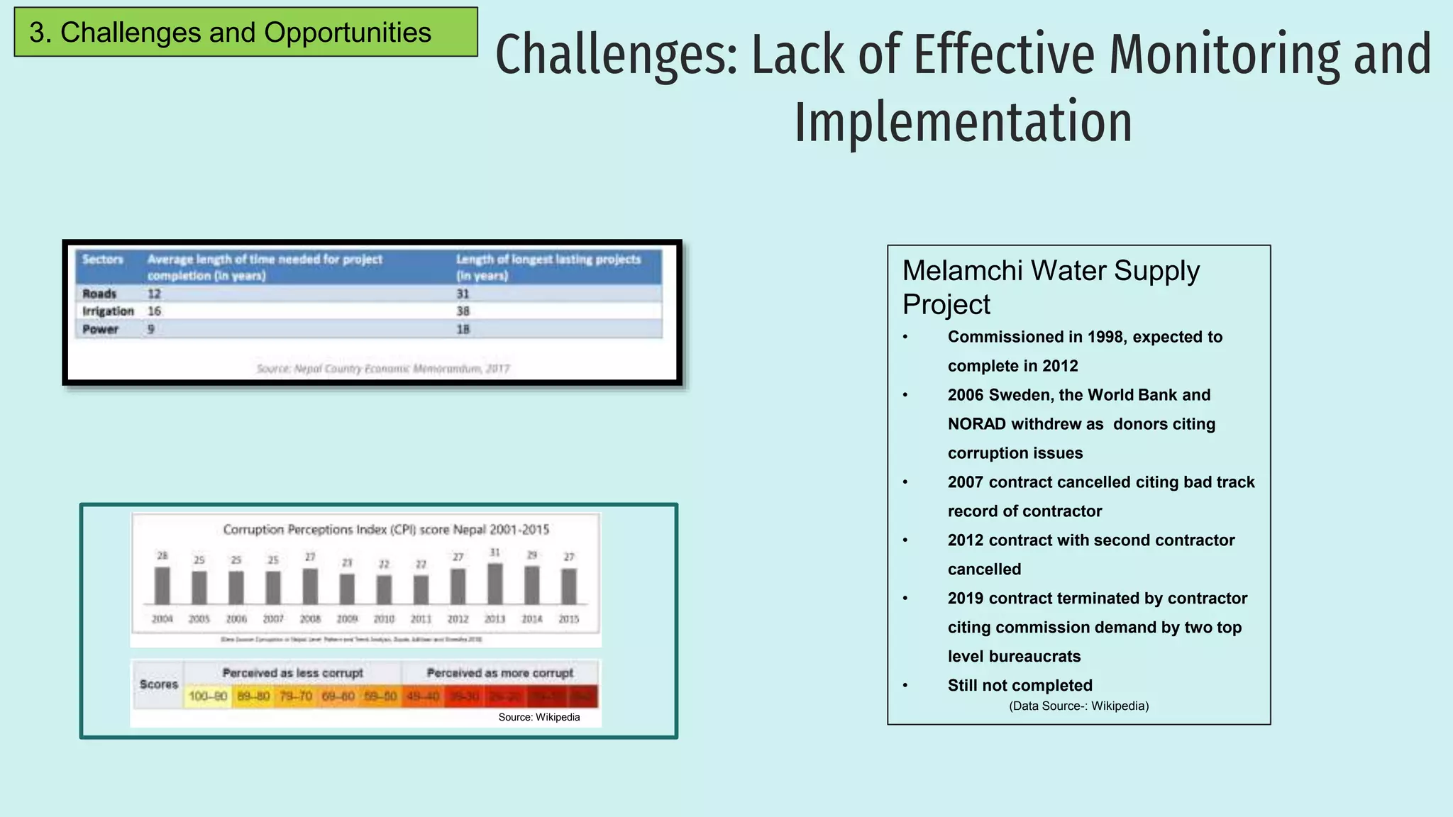
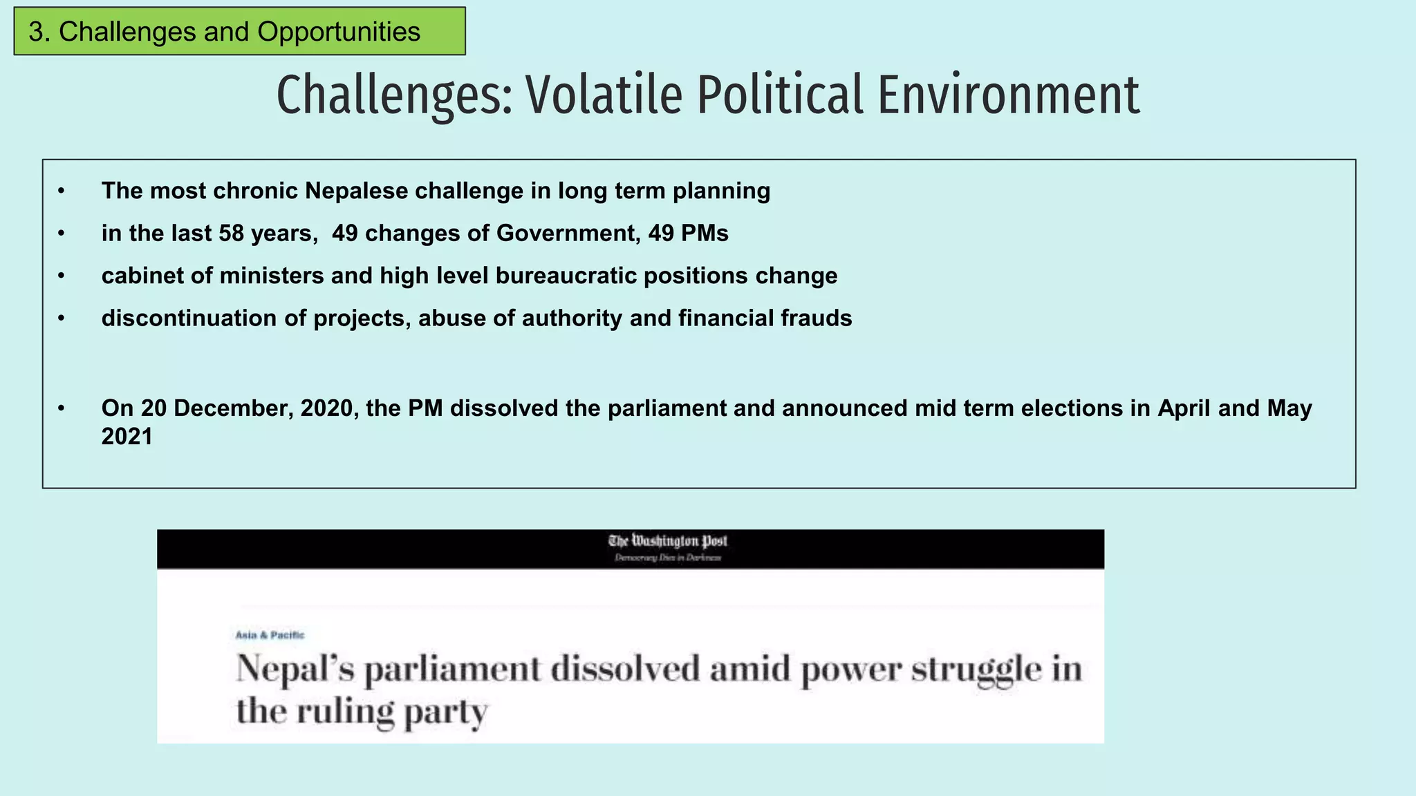
This presentation was prepared as part of my Regional Planning I course in the University of Stuttgart. I have researched the context of Nepal, present status of development and the challenges of Regional Planning in Nepal.
A Presentation made to the student of BDevS at Center for Development Studies, National College for Higher Education, KU in October 2014, kathmandu, Nepal
Review of Development Plans/ Master Plans of selected cities of India.KARTHICK KRISHNA
This is an academic assignment done for the purpose to draft a master plan/ development plan. This helps us to identify the concept and context of the various plans and its development proposals applicability and replicability.
Analysed Parameters:
1.Condition Of Census House
2.Housing Structure
3.Ownership Status Of The House
4.Material of Roof and Wall
5.Number of Dwelling Rooms
6.Latrine Facility
7.Status of Housing
8.Housing Demand, Supply and Shortage
9.Obsolescence Factor
10.Homeless Factor
An urban area is characterized by higher population density and vast human features in comparison to areas surrounding it. Urban areas may be cities, towns or conurbations, but the term is not commonly extended to rural settlements such as villages. Any portion of earth’s surface where physical conditions are homogeneous can be considered as a Region in geographic sense, ranging from a single feature region to compage, depending on the
criteria used for delineation. In practice, a prefix is added to highlight the attributes on which the region has been defined, for example, agriculture region, resource region, city region, planning region.
All the daily activities of human beings are carried out on land. Proper organization of these activities i.e. planning will help the human being in leading a richer and fuller life in livable surroundings or environment. "Planning" means the scientific, aesthetic, and orderly disposition of land, resources, facilities and services with a view to securing the physical, economic and social efficiency, health and well-being of urban and rural communities.
Urban planning and urban design are two closely related fields that aim to shape and improve the built environment in cities and urban areas. Urban planning involves the development and implementation of policies and strategies to guide the growth and development of cities, while urban design focuses on the physical and aesthetic aspects of the built environment, including the design of buildings, public spaces, and transportation systems. Together, these disciplines seek to create livable, sustainable, and inclusive urban environments that meet the needs of diverse communities.
Pursuing any development or neighborhood plan today involves
working with a myriad of actors beyond professional collaborators
during planning and design phases. These include direct abutters,
surrounding neighbors, elected offi cials, public agencies, opponents
(often), investors, financial institutions, and regulators, all billed as
“stakeholders.” Navigating the shoals created by cadres of stakeholders
is perhaps the greatest challenge to pursuing sophisticated
ideas about and goals for urbanism.
Consensus around goals that arenot very ambitious is, unfortunately, common. However, rather thanwallow in despair about the unpredictable nature of decentralized processes, urban designers must learn to be more effective collaborators,willing participants in true interdisciplinary endeavors, and advocatesfor ideas not always their own, ideas that have the potential
to rally others around higher expectations, not expedient solutions.
Such skills are not always available in a designer’s tool kit.
Some blame the messiness of democratized processes for producing mediocrity.
On the other hand, many can offer examples of substantial benefits to projects as a result of broader community participation.
Then, too, there is that maxim among seasoned urban designers, “To
envision takes talent, to implement takes genius.”
National Urban Housing and Habitat Policy-2007JIT KUMAR GUPTA
Presentation looks at the intent, content and scope of National Housing Policy 2007; Housing Finance Institutions, PMAY(U), in the context of housing for all in urban India
Mexican Sustainable Urban and Mobility Strategy and Climate ChangeFagner Glinski
El sábado 6 de diciembre del 2014, en el Congreso de la República del Perú, se llevó a cabo, como evento oficial de COP20, la Conferencia Internacional “Movilidad Sustentable y Cambio Climático”. Allí, la Cumbre de Ciudades Líderes en Movilidad Urbana Sustentable de América Latina – MUSAL – y la Asociación Latinoamericana de Sistemas Integrados y BRT – SIBRT – hicieron el lanzamiento de la “Declaración de Lima: Libro Blanco de la Movilidad Urbana Sustentable de América Latina”, publicación que contó con la participación y auspicio de la Organización Panamericana de la Salud (OPS/OMS).
Sanath Ranawana, Asian Development Bank
Presentation:
Greater Mekong Sub-region Natural Capital Partnership: key conclusions from recent Ministerial-level meeting
Impact of road extension project on the residents of ktmNabin Bhattarai
This report is the study of the impacts of road extension project on the residents of Kathmandu valley. The project was initiated by former prime minister Dr. Baburam Bhattarai. the project tremendously affected the living condition of people.
An Interpretive Study on Information Usage and ICT Adoption in Rural AreasDoy Sundarasaradula
This project is an exploratory research on the usage of information and the adoption of ICT in rural areas of participating ASEAN countries to generate understanding, insights, and useful information that assist in formulating appropriate policy and planning for USO and/or similar projects to optimise financial resources allocation and maximise social and economic benefits and welfare arising form implementing such projects.
Rural Infrastructure Development Projects Under MGNREGA, Clean Village : A St...'Denish Makvana'
(1)Rural Infrastructure Development Projects Under MGNREGA,
(2)Clean Village : A Step Towards Clean India Campaign,
(3)Concept Sustainable Planning Of feasible Infrastructure Facilities And Tourism Site Development.
Urban planning is the process of developing and designing urban areas. Encompassed in that process is the use of open land, air, water, and the built environment, including buildings, transportation, economic and social functions. Typically used as part of a larger city plan, an urban plan should tie back to an organization’s mission and vision statements.
This report will provide a great deal of data for planning Pabna Municipality. The source are old but might give a better result in analysis for urban planning. We can have a proper idea of how to plan a municipal area in the future, control urban growth, and increase utility services for betterment of the people living in an urban area
Nepal is beautiful country. According to new geographical structure there are six metropolitan
cities, eleven sub-metropolitan cities. Seventeen cities are already urbanized and two hundred and
seventy-six municipalities are also newly emerging cities. The objective of this research is mainly
urban infrastructure development, its challenges, explore the problems, identify defective
coordination within the interdisciplinary ministry, suggest for integrated infrastructure, to aware
risk factors associated during urban infrastructures. The methodology adopted was according to
various literature reviews and surveys conducted on the sport. Respondent were selected from
concerned authorities, this research shows everyone want affordable housing, public hospital,
school, college, university, drinking water, communication, drain and sanitation facilities and wide
road are prime needs. It was found the defective procurement policy including various risk factors,
a lack of adequate government’s act with necessary policies, vision of leader is not globally
thinking and locally acting, human resource is not compatible, the poor performance of contactor
and consultant, project manager is not being professional and allocating budget is not enough,
since one authority built, immediately other authority dig the trench. if government started
integrated urban infrastructure projects would better for future and proper risk management plan
needs to establish.
NCR REGION
NCR: Constituent Areas
Enactment of NCR Planning Board Act, 1985
Growth of Pop. & Decadal Growth rate - Delhi (1901-2001)
NCR population distribution
Sub-region wise Population of NCR
Regional Plan-2021 for NCR: Aim and Objectives
Regional Plan-2021 for NCR: Policy Zones
Impact of Delhi Master Plan
Conclusion
Water scarcity is the lack of fresh water resources to meet the standard water demand. There are two type of water scarcity. One is physical. The other is economic water scarcity.
Explore the innovative world of trenchless pipe repair with our comprehensive guide, "The Benefits and Techniques of Trenchless Pipe Repair." This document delves into the modern methods of repairing underground pipes without the need for extensive excavation, highlighting the numerous advantages and the latest techniques used in the industry.
Learn about the cost savings, reduced environmental impact, and minimal disruption associated with trenchless technology. Discover detailed explanations of popular techniques such as pipe bursting, cured-in-place pipe (CIPP) lining, and directional drilling. Understand how these methods can be applied to various types of infrastructure, from residential plumbing to large-scale municipal systems.
Ideal for homeowners, contractors, engineers, and anyone interested in modern plumbing solutions, this guide provides valuable insights into why trenchless pipe repair is becoming the preferred choice for pipe rehabilitation. Stay informed about the latest advancements and best practices in the field.
CFD Simulation of By-pass Flow in a HRSG module by R&R Consult.pptxR&R Consult
CFD analysis is incredibly effective at solving mysteries and improving the performance of complex systems!
Here's a great example: At a large natural gas-fired power plant, where they use waste heat to generate steam and energy, they were puzzled that their boiler wasn't producing as much steam as expected.
R&R and Tetra Engineering Group Inc. were asked to solve the issue with reduced steam production.
An inspection had shown that a significant amount of hot flue gas was bypassing the boiler tubes, where the heat was supposed to be transferred.
R&R Consult conducted a CFD analysis, which revealed that 6.3% of the flue gas was bypassing the boiler tubes without transferring heat. The analysis also showed that the flue gas was instead being directed along the sides of the boiler and between the modules that were supposed to capture the heat. This was the cause of the reduced performance.
Based on our results, Tetra Engineering installed covering plates to reduce the bypass flow. This improved the boiler's performance and increased electricity production.
It is always satisfying when we can help solve complex challenges like this. Do your systems also need a check-up or optimization? Give us a call!
Work done in cooperation with James Malloy and David Moelling from Tetra Engineering.
More examples of our work https://www.r-r-consult.dk/en/cases-en/
About
Indigenized remote control interface card suitable for MAFI system CCR equipment. Compatible for IDM8000 CCR. Backplane mounted serial and TCP/Ethernet communication module for CCR remote access. IDM 8000 CCR remote control on serial and TCP protocol.
• Remote control: Parallel or serial interface.
• Compatible with MAFI CCR system.
• Compatible with IDM8000 CCR.
• Compatible with Backplane mount serial communication.
• Compatible with commercial and Defence aviation CCR system.
• Remote control system for accessing CCR and allied system over serial or TCP.
• Indigenized local Support/presence in India.
• Easy in configuration using DIP switches.
Technical Specifications
Indigenized remote control interface card suitable for MAFI system CCR equipment. Compatible for IDM8000 CCR. Backplane mounted serial and TCP/Ethernet communication module for CCR remote access. IDM 8000 CCR remote control on serial and TCP protocol.
Key Features
Indigenized remote control interface card suitable for MAFI system CCR equipment. Compatible for IDM8000 CCR. Backplane mounted serial and TCP/Ethernet communication module for CCR remote access. IDM 8000 CCR remote control on serial and TCP protocol.
• Remote control: Parallel or serial interface
• Compatible with MAFI CCR system
• Copatiable with IDM8000 CCR
• Compatible with Backplane mount serial communication.
• Compatible with commercial and Defence aviation CCR system.
• Remote control system for accessing CCR and allied system over serial or TCP.
• Indigenized local Support/presence in India.
Application
• Remote control: Parallel or serial interface.
• Compatible with MAFI CCR system.
• Compatible with IDM8000 CCR.
• Compatible with Backplane mount serial communication.
• Compatible with commercial and Defence aviation CCR system.
• Remote control system for accessing CCR and allied system over serial or TCP.
• Indigenized local Support/presence in India.
• Easy in configuration using DIP switches.
Sachpazis:Terzaghi Bearing Capacity Estimation in simple terms with Calculati...Dr.Costas Sachpazis
Terzaghi's soil bearing capacity theory, developed by Karl Terzaghi, is a fundamental principle in geotechnical engineering used to determine the bearing capacity of shallow foundations. This theory provides a method to calculate the ultimate bearing capacity of soil, which is the maximum load per unit area that the soil can support without undergoing shear failure. The Calculation HTML Code included.
Hierarchical Digital Twin of a Naval Power SystemKerry Sado
A hierarchical digital twin of a Naval DC power system has been developed and experimentally verified. Similar to other state-of-the-art digital twins, this technology creates a digital replica of the physical system executed in real-time or faster, which can modify hardware controls. However, its advantage stems from distributing computational efforts by utilizing a hierarchical structure composed of lower-level digital twin blocks and a higher-level system digital twin. Each digital twin block is associated with a physical subsystem of the hardware and communicates with a singular system digital twin, which creates a system-level response. By extracting information from each level of the hierarchy, power system controls of the hardware were reconfigured autonomously. This hierarchical digital twin development offers several advantages over other digital twins, particularly in the field of naval power systems. The hierarchical structure allows for greater computational efficiency and scalability while the ability to autonomously reconfigure hardware controls offers increased flexibility and responsiveness. The hierarchical decomposition and models utilized were well aligned with the physical twin, as indicated by the maximum deviations between the developed digital twin hierarchy and the hardware.
RAT: Retrieval Augmented Thoughts Elicit Context-Aware Reasoning in Long-Hori...
Regional Planning in Nepal: Prospects and Challenges
1. Regional Planning
in Nepal: Prospects
and Challenges
Ashish Dangal
Master‘s Student Infrastructure Planning
University of Stuttgart
3 February, 2021
2. Important Disclaimer
New Political Map of Nepal endorsed on May 20, 2020
Previously Used Political Map of Nepal
On May 20, 2020, the Government of Nepal endorsed a new Political Map of Nepal with
a segment of territory added in the upper left corner.
The old Political Map in this presentation is used for demonstration purposes only due to
lack of availability of Geodata pertaining to the new Political Map.
3. Location and Key Indicators
Data Source: data.worldbank.org, Wikipedia
* Rank in the World in descending order
1. The Context of Nepal
Key Metrics of Nepal
Metrics/Indicators Nepal
Population (in Mio.) 28.6 (2019) (49th)*
Area (in sq. km) 147,516(93rd)*
Nominal Gross Domestic
Production(GDP)
$30.6 Billion (2019) (101st)*
Major Sources of National
Income
Foreign
Remittance(26.9%of
GDP in 2019), Tourism
(7.9% of GDP in 2017),
Carpets and Textiles
Per Capita Income $1,090 (2019) (159th)*
Human Development Index
(HDI)
0.579 (147th)*
4. An overview of the Nepalese Economy
Imports (2018) Exports (2018)
$10.1 Billion $723 Million
Data Source: 2020 CIA WORLD FACTBOOK, www.oec.world
1. The Context of Nepal
Data Source: 2020 CIA WORLD FACTBOOK, www.oec.world
6. Settlement Patterns
Typical Settlement in Rural Mountain Region
Typical Settlement and Agriculture in Rural Hill Region
Typical Settlement and Agriculture in Rural Terai Region
1. The Context of Nepal
Typical Urban Settlement-Kathmandu
7. Demographic Trend
1. The Context of Nepal
• At 16.8 Million active population, currently
the 37th largest workforce in the world
• Ageing Society in 2028
(Data Source:DEMOGRAPHIC CHANGES OF NEPAL: Trends and
Policy Implications , NPC, 2017)
8. So Near, yet so Far: My own Experience
Bhotenamlang School
• Total Students: 627
• Total Teachers: 11
• Student to Teacher Ratio: 1:57 (Govt. Recommendation
< 1:40)
(Source: School Records 2016)
1. The Context of Nepal
9. History of National Level Planning
The National Planning Commission (NPC)
• first created in Nepal in 1956.
• formulating national vision, development policy,
periodic plans and sectoral policies for overall
development of the nation.
1. The Context of Nepal
10. After 2015
Administrative Divisions : Past and Present
Until 2015
Decentralization has been the major running target of the administration
divisions.
1. The Context of Nepal
13. Strategic Transportation Network
Nepal Road Network
• Strategic Roads Network
a) Highways
b) Feeder Roads
• Local Road Network
a) District Roads
b) Urban Roads
2. Present Status of Development
• 60% of the road network is
concentrated in the Terai region
• 50% of the population of the
hilly region still need to walk 2
hours to reach an SRN road.
• 2 district headquarters still not
connected to the SRN
Source: Sector Assessment (Summary): Road
Transport, ADB, 2015
14. National Pride Projects
2. Present Status of Development
With a length of 1776
km, the Mid Hill
highway connects 24
hilly districts directly
affecting about 7
million people.
15. New Settlements Plan and Progress
• 30 other new cities in other regions are
in different phases of execution
• 10 New Towns along the Hilly Region
• Commissioned in 2011
• Estimated Budget NPR 150 Billion
• Expenditure till 2019 NPR 5 Billion
2. Present Status of Development
16. Water Resources Management
Irrigation
• 81% of irrigable land is irrigated
• Only 35% of irrigated land has year-round irrigation
facility
Water Supply
• 86% of the Population has access to Water Supply
Power Supply
• Nepal has economical Hydropower potential of
about 42,000 MW
• As of 2017, Nepal has been able to generate 501
MW
• Peak demand in Winter, 2016 was1198 MW
501 MW- met internally
468 MW- imported from India
268 MW- Load Management
(Data Source: Nepal’s Water Resources and its Development Strategy, Pradhan, 2018)
2. Present Status of Development
17. Internal Migration
3. Challenges and Opportunities
• Internal Migration is the largest contributor to urban growth (MOUD,2015)
• 40 new cities are planned keeping in view this trend of internal migration
18. Urbanization
3. Challenges and Opportunities
Land use change in Kathmandu 1989-2016
Challenges of Urbanization in Nepal
• Lack of Planning and large and growing infrastructure deficits (Managing
Nepal‘s Urban Transition, World Bank, 2013)
• Problems of drinking water, sanitation, air pollution, squatter settlements
(Challenges of Inclusive Urbanization in the Face of Political Transition in Nepal, Mugambwa &
Katusiimeh,2018)
Opportunities
• New towns and cities
Level of Urbanization
Kathmandu 96.97%
Pokhara 79.52%
Rest of the Hill Region 18.28%
Inner Terai Valley 41.97%
Rest of Terai 38.94%
Source: National Urban Development Strategy, 2017
19. Challenges: Lack of Proper Planning and
Implementation Tools
• Planning guidelines not contextualized
• No Centralized GIS database of infrastructure projects
• No evidence based planning of medium and small scale projects
• Data not easily accessible
My Experience in Hetauda
2 Ministries commissioned the same Project
• Ministry of Physical Infrastructure Development, Province 3
• Ministry of Forest, Environment and Industries, Province 3
3. Challenges and Opportunities
20. Challenges: Lack of Effective Monitoring and
Implementation
Source: Wikipedia
Melamchi Water Supply
Project
• Commissioned in 1998, expected to
complete in 2012
• 2006 Sweden, the World Bank and
NORAD withdrew as donors citing
corruption issues
• 2007 contract cancelled citing bad track
record of contractor
• 2012 contract with second contractor
cancelled
• 2019 contract terminated by contractor
citing commission demand by two top
level bureaucrats
• Still not completed
(Data Source-: Wikipedia)
3. Challenges and Opportunities
21. Challenges: Natural Hazards and Climate Change
Nepal‘s Rank in Global Risk
Assessment Studies
Climate Risk- 4th (Global Climate Risk Index)
Earthquake Risk- 11th (Global Risk for Earthquake Occurence
and Impact)
Flood Risk- 30th (UNDP / BCPR, 2004)
Total Natural Hazard related deaths- 23rd
3. Challenges and Opportunities
22. Opportunities: Climate change and Disaster Risk Management Plan
3. Challenges and Opportunities
Disaster Relief and Response
1997-2002
Disaster Management
2003-2007
Climate Change Adaptation
2008-2010
Localised CCA and DRR
2011
Figure: Timeline of CCA and DRR Policy Development Nepal
Source: London School of Economics and Political Science, 2019
• Climate Change and Disaster Risk are aggravating
the Regional Disparity in Nepal inducing Poverty and
Migration and destruction of built Infrastructures.
• Initially DRR and CCA were addressed separately.
But now a new Framework is being practiced by
integrating DRR and CCA.
• The German Agency GIZ has helped prepare a
guidebook for Preparation of Local Disaster and
Climate Resilience Plan for the Local Governments
• All Local Governments have either prepared or are
preparing contextual LDCRP
24. Opportunities: Ropeway Development
• Ropeways are better alternative than roads in disaster-prone hilly areas -Nepal Country
Report, World Bank , 1976
• Ropeways are relatively viable as compared to roads- Cheaper to build, operate and
maintain, negligible harm to the environment, less pollution, less noise, less space
requirement, less construction work, less slope destabilization, less risk of triggering
landslides, less risk of floodings, no major bridges required, powered by electricity- a
resource abundant in Nepal
Manakamana Cable Car, Kurintar Chandragiri Cable car, Kathmandu
3. Challenges and Opportunities
25. Challenges: Volatile Political Environment
• The most chronic Nepalese challenge in long term planning
• in the last 58 years, 49 changes of Government, 49 PMs
• cabinet of ministers and high level bureaucratic positions change
• discontinuation of projects, abuse of authority and financial frauds
• On 20 December, 2020, the PM dissolved the parliament and announced mid term elections in April and May
2021
3. Challenges and Opportunities
Classification of road system. Explain the points.
roads in hilly areas where construction and maintainance costs of roads tend to be very high
The government has not shown much interest in Ropeways development
Private investors have invested in some Ropeway sytems to connect people to otherwise remote religious places.