Downloaded 14 times
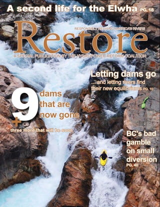


![cur rent
U. of Minnesota’s Center for
Earth’s Surface Dynamics is
the place to go for models.
photography by gordon grant
Role of the model
W
hen a group of fishermen decided in prediction of a scaled, 60-foot-long, five-foot-wide
10 to remove a Rogue River dam, model of the Sandy River.
they didn’t conduct feasibility stud- When the Elwha and Glines Canyon dams come out
ies, environmental impact studies or starting in the fall 011, a 5-foot-long scaled model
sediment studies. All they did, was light the fuse. will guide the $51 million deconstruction.
Stream ecology has progressed in the last century The researcher involved with both of these models
and hydrologists today often rely on models to reduce is Gordon Grant, a research hydrologist from Oregon
uncertainty in large-scale projects. State University and the U.S. Forest Service. Below
The removal of Marmot Dam relied on the are his words on the models.
ACCURACY: We were surprised at how quickly the model. We wrote a paper on it. It’s great fun.
sediment [at Marmot Dam's removal] was evacuated PAPIER MAChE? The basic form is plywood with
under very modest flow conditions. About 20 percent concrete poured over the form and painted. The
of the total volume [of sediment] stored, was evacuated Marmot model cost $30,000 to $40,000.
during the first 48 hours. It came out very quickly. The WhO BUILDS ThEM: [The University of
physical model predicted that, but we didn’t believe Minnesota’s Center for Earth’s Surface Dynamics] are
it. On the river … the numerical models predicted masters of the model. [The Marmot model] took about
that sand would flush and gravel would linger … The a month to build, for a team of four to five people.
models predicted that pretty well. The team consists of lab techs and engineers. Lots of
TRIAL AND ERROR: [Physical] models are engineering is done with these models.
expensive and hard to build. We use them to test n To see video of the model’s construction and test go
ideas. No one had done this [removed a significant to: http://www.youtube.com/watch?v=sd2CfsFpjAU
dam with natural erosion] before. [The models] get and
run a lot. We ran 10 experiments with the Marmot http://www.youtube.com/watch?v=UTMW4-PVPI8
www.hydroreform.org n Winter 011 n RESTORE n 15](https://image.slidesharecdn.com/r75restore-for-web-110425022131-phpapp01/85/R75-restore-for-web-15-320.jpg)


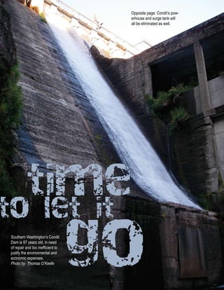
![release
To see time-lapse video, go
to: http://www.youtube.com/
watch?v=CaNb2wouYUk
months of negotiation, members of the Hydropower The main concerns about blocking never
Reform Coalition, Portland General Electric and 21 materialized,” Esler says. “We had Coho spawning the
other signatories had considered two plans: Excavate next week. Literally. It was amazing. You could stand
the sediment mechanically or allow the river to erode up on the bridge, look downstream and feel like you
it naturally. were looking at a river in the Olympic Peninsula.”
The former plan would be expensive, would The Sandy River’s faster-than-hoped-for
require at least a year of excavation and would stir restoration has been the reward for PGE’s pursuit
up turbidity that could choke salmon for the entire of a modeled, yet untried method of removal. But
time. According to a the impetus for removal wasn’t
plethora of models, environmental.
the latter option
would be faster,
MARMOT DAM It was economic. PGE began
preparing to renew its license in
more natural and n organizations signed the 1998—six years before its
unprecedented. settlement agreement current license would expire.
“At the time, it n First major U.S. Its financial officers
represented the single dam to be removed quickly realized the 22
largest instantaneous with natural erosion megawatts of power wouldn’t
SANDY RIVER
release of sediment,” method justify the expense of the
Gordon Grant says. n 00,000 cubic modifications necessary to
Portland General yards of sediment relicense the project.
Electric began was -feet thick “It came down to simple
preparing for the and extended a mile exercise,” Esler says. “On one
removal late in the upstream side, we were considering
summer of 2007, n The 00 removal connected 100 what the agencies were asking for,
when the water was miles of river such as higher flows, rebuilding the
low. And on October n PGE donated 1,500 acres of land to fish ladder, a screen system that put
19, 2007, after a the public fish back into the river, the need
series of rainstorms to leave water in the Little Sandy,”
swelled the Sandy Esler says.
and strained the cofferdams, PGE provided the final “Then, with a simple Excel spreadsheet, we added up
push that allowed the river to once again control the the costs that we were going to do, plus maintenance.
riverbed. On other side, we considered the value of energy. It
“For me personally, it moved faster than I had was about a wash.”
anticipated,” says John Esler, one of PGE’s project The removal connected 100 miles of river, and led
managers for the removal. “Once the cofferdam was to the donation of 1,500 acres of PGE’s land to the
moved out of the way, the sediment just left. About public.
as fast as you could watch it. It came out amazingly “As much as the public complains about dams on
fast.” rivers, they get used to dams on rivers,” Elser says.
The next three or four storms continued to disperse “That’s the status quo. If we had not been as committed
the sediment. The fine sands, the stuff that can choke as an entity to see this thing through, there would have
or suffocate fish, moved through the system quickly, been 100 ways to stall this thing from happening.
Esler says. The team [at] PGE had to bulldog this to keep it on
The gravel never blocked side-channels. track. But it’s understandable. It was different. No one
It never cut off the tributaries. had ever done this before.”
www.hydroreform.org n Winter 011 n RESTORE n 21](https://image.slidesharecdn.com/r75restore-for-web-110425022131-phpapp01/85/R75-restore-for-web-21-320.jpg)


![release
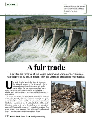
Husum Falls and Double Drop
are a few of the rapids that
attract thousands of paddlers.
at the head of Northwestern Lake that would release the advantage of a dry lakebed. The dam would be
00 cfs into the .-mile bypass reach. This would gone in one year. FERC predicts this method would
provide full fish passage and eliminate the need to release a lethal amount of sediment downstream that
remove the trapped silt. would eliminate entire fish populations, scour a .-acre
The signature of the partial removal option is the wetland and, for two years, bury the spawning beds
construction of a waterfall directly downstream of the at the Bonneville Pools at the mouth of the Columbia.
removed dam. PacifiCorp would mitigate these temporary impacts
The intent of this system is to allow upstream and through engineering, fish capture and hatchery, and
downstream fish and kayak passage. the development of several programs.
—FERC Environmental Impact Statement (EIS), “In the 16 FEIS, we concluded that the no-
October 16; retrieved from: http://elibrary.ferc.gov/ sediment treatment would be unacceptable because
idmws/common/OpenNat.asp?fileID=11010 it would result in the long-term (10-to 0-year)
2002 FERC removal option deposition of sediments …” the 00 FERC EIS says.
1.) Settlement Agreement: Twenty-three signatories “[T]he issue [with no sediment treatment] is where the
agreed to cap PacifiCorp’s liability at $17.15 million (in sediments are deposited, not how they get there.”
1999 value). The plan calls for PacifiCorp to excavate The plan earned the support of vested interests,
a 1-foot-high by 1-foot-wide drain tunnel at the ranging from those representing conservation and
base of Condit Dam. Models predict this would drain fishing to utilities and the Yakama Nation. FERC
the lake at a rate of 10,000 cubic feet per second amended the settlement agreement with additional
and would flush 65 to 0 percent of the sediment mitigations. This plan provides the blueprint for
downstream. In six hours, Northwestern Lake would removal in October 011.
be gone. --Federal Energy Regulatory Commission. (2002).
Using rock-quarrying techniques, PacifiCorp crews Final Environmental Impact Statement. Washington
would then remove the dam and power station with D.C. pp. B-6.
Photo by Thomas O’Keefe
www.hydroreform.org n Winter 011 n RESTORE n](https://image.slidesharecdn.com/r75restore-for-web-110425022131-phpapp01/85/R75-restore-for-web-29-320.jpg)


![release
Seattle City Light recognized
Sullivan Creek’s value as a
cold water tributary.
restoration or decrease the temperature of the Pend affairs for the Pend Oreille PUD. “We’ve been trying
Oreille River. This is an impossible task, considering to put generation in there since. The last time we tried,
the Pend Oreille drains 25,000 cubic miles, starting the conditions made power too expensive.”
in Montana. Even in September, it gushes 15,000 So in 2003, the PUD gave up. It asked the Federal
cubic feet per second. Energy Regulatory Commission [FERC] for permission
In the winter of 2009, U.S. Forest Service to surrender the project.
representatives Glen Koehn and Kristen Bonanno Before FERC could agree, American Whitewater and
helped put the two interests the United States Forest Service
together. Sullivan Creek, appealed the request.
they argued, was the biggest American Whitewater
tributary in the Boundary SULLIVAN CREEK and the Forest Service were
Dam area and as such, n Is the most significant cold water concerned Pend Oreille PUD
represented Seattle City stream in the Pend Oreille would simply walk
Light’s best hope for cold watershed away from the 50-
water and Bull Trout habitat. n Removal of Mill foot obstruction and
The removal of Mill Pond Pond Dam would let it decay into the
Dam would satisfy these two open 16 miles of landscape.
SULLIVAN CREEK
conditions of relicensing for cold water habitat “There’s all these
Seattle City Light. n Settlement dams around the
As it happens, Seattle agreement signed country that no one
City Light had been March 010; FERC owns and no one
anxious to demonstrate expected to approve settlement manages,” says Kevin
its own commitment to its agreement in the fall 011 Colburn, stewardship
stewardship mission and n The Lands Council, Selkirk director for American
this, officials agreed, was a Conservation Alliance, American Whitewater. “We were very
perfect opportunity. Whitewater helped form solution. concerned the same thing
“We’re very excited about could happen to this one. A
it,” says Barbara Greene, a lot of the project had already
project manager for Seattle been abandoned. The flume
City Light. “This gives us a chance to pursue our that carried water for the hydro project was allowed
stewardship goals. When they asked us to come to to disintegrate. Decades ago, they had poured
the negotiation process in the winter of 2009, we cement into the turbines of the powerhouse. And it
were very excited.” stopped generating power in the mid-50s.”
All 17 parties signed the agreement, which plans Cauchy, Pend Oreille PUD’s director of regulatory
for the removal of Mill Pond Dam. This will free up and environmental affairs, doesn’t disagree.
all 18 miles of Sullivan Creek from Pend Oreille Lake “We didn’t know what was going to happen to the
to its mouth on Pend Oreille River. Consensus—even dam,” he says. “Our intention was to have an open
ambivalent consensus—is a welcome destination mind in negotiations. Potentially, the dam could have
for any relicensing journey. Considering where this stayed. It could have had fish passage. Or it could have
debate started, however, consensus seems almost been removed. We didn’t know.”
miraculous. Mill Pond Dam hadn’t produced a watt In the end, however, everyone got what they wanted.
of electricity since 1954 and in 2008, the license for And in less than a decade, Sullivan Creek will run free
Pend Oreille PUD to operate it, would expire. for the first time since 1908.
“We’ve had that project since 1958,” says Mark “This one was very, very cool,” says Colburn. It was
Cauchy, director of regulatory and environmental an elegant solution.”
www.hydroreform.org n Winter 011 n RESTORE n 39](https://image.slidesharecdn.com/r75restore-for-web-110425022131-phpapp01/85/R75-restore-for-web-39-320.jpg)
![cur rent
Construction on the Ashlu
reveals the so-called “minimal
impacts” of small hydro.
photography by brian smith and rich bowers
Power rush
British Columbia has marketed its signature resource as green energy.
Their impacts, however, are not be so green, or easy to sell.
B
ritish Columbia’s resigning Premier Hydro. “Meanwhile, exports collapsed by 50 percent
spent much of August 2010 peddling in 2009/2010.”
his signature product—run-of-river This, coupled with reduced energy demand
hydropower—to his province’s biggest throughout the province has the economist
potential customer: The state of California. suspicious.
With the prospects of a sale in California growing “As the evidence of need for more electricity in BC
dim, however, the premier has now shifted his pitch is not apparent, the aggressive borrowing/investing/
to Oregon and Washington. contracting with IPPs is plain wrong,” he concludes.
Finding a buyer for the surplus of energy British The day after Gordon Campbell became the premier
Columbia has generated off run-of-river hydro has of British Columbia in 2001, he made good on his
become a provincial controversy, as the price of that vow to reduce personal income taxes by 25 percent.
energy has become more apparent. In his first year, he cut most corporate income taxes
“[BC] Hydro is paying IPPs more than double and eliminated the Corporation Capital Tax. To pay
the open market rates prevailing in western North for these cuts, Campbell sold off some of British
America,” wrote economist Erik Andersen in his Columbia’s most prized assets — its ferry and railway
August 16, 2010 article Sinister Vectors at BC system and the power producing core of BC Hydro.
0 n RESTORE n Winter 011 n www.hydroreform.org](https://image.slidesharecdn.com/r75restore-for-web-110425022131-phpapp01/85/R75-restore-for-web-40-320.jpg)


This document discusses dam removal as a tool for river restoration. It provides an overview of dam removal nationally and in the Pacific Northwest. Specific examples of removed dams are given for Alaska, Montana, Oregon, and Washington. The benefits of dam removal include restoring hundreds of miles of river habitat and improving fish, wildlife, recreation, water quality, and flood protection. The concept of removing aging dams is becoming more accepted as their benefits diminish over time but risks increase due to safety and environmental concerns. Letting rivers find their natural equilibrium through dam removal, while sometimes messy, is ultimately beneficial.


