Download to read offline
![International Research Journal of Engineering and Technology (IRJET) e-ISSN: 2395-0056
Volume: 04 Issue: 03 | Mar -2017 www.irjet.net p-ISSN: 2395-0072
© 2017, IRJET | Impact Factor value: 5.181 | ISO 9001:2008 Certified Journal | Page 1904
PROVIDING A BORDER ALERT SYSTEM FOR FISHERMEN
BY USING GPS & GSM TECHNOLOGY IN WIRELESS SENSOR NETWORKS
Dr.K.Karuppasamy M.E., Ph.D1, Jagadheesh K2,Nehru K 3 ,Sindhu Meena K4 ,Vignesh S5
1Head of the Department, Dept of Computer Science & Engineering, RVS College of Engineering &Technology,
Coimbatore, Tamil Nadu, India.
2UG Student, Dept of Computer Science and Engineering ,RVS College of Engineering & Technology, Coimbatore,
Tamil Nadu, India.
3UG Student, Dept of Computer Science and Engineering, RVS College of Engineering & Technology, Coimbatore,
Tamil Nadu, India.
4UG Student, Dept of Computer Science and Engineering ,RVS College of Engineering & Technology, Coimbatore,
Tamil Nadu, India.
5UG Student, Dept of Computer Science and Engineering, RVS College of Engineering & Technology, Coimbatore,
Tamil Nadu, India.
-----------------------------------------------------------------------***-------------------------------------------------------------------------
Abstract : -The main idea to design a border alert
system is to safeguard the fishermen from being caught by
SriLankans in coastal area. In this system we implement
GPS and GSM technology .The GPS technology is to
navigate or to track the current location of a boat.
Whenever fishermen reaches the warning border, the
border security forces will send notification to the LCD
display in ship, so that fishermen will be alerted. Even if
they dint stop the boat, we use a relay to stop the boat.
The relay will cut off the power supply to the motor, so
that boat will be automatically stopped. This system is
mainly designed for Tamil fishermen.
Keywords-GPS tracker, GSM communication, Relay.
1.INTRODUCTION
Sri Lanka and India seaside nations are isolated
by their sea borders. In Tamil Nadu about 20,000
vessels make spinning in the Bay of Bengal. The main
aim is to give a well equitable user friendly environment
for Indian Fisherman to handle hazardous situation with
the help of engine control. This paper comes with a
consistent solution for this problem and protects the
Indian fisherman from dangerous situation and being
crossing the maritime boundary and save their life and
improve the safety of fisherman. The system is designed
by using GPS and GSM. A GPS route device is a device
that precisely discovers natural area by getting data
from GPS satellites. This device can track the GPS data
every single time at whatever point the fisher man's
cross the Indian border. It is a significant depression
issue and encourages trouble in the both people and
also their economic expenditures.
2.LITERATURE SURVEY
D.Jim Isaac et al [1] the paper titled as
“Advanced border alert system using GPS and with
intelligent Engine control unit “In our system using GPS
and GSM, where GPS is used to find the location of the
boat. If the boat nearer to the boundary primarily it
warning for a fishermen with the alarm and emits the
location of the boat to the nearest coast office via GSM
communication. When it further nears the maritime
boundary an interferer is sent to the Engine Control Unit
which controls the speed of the engine with the help of
the electronic fuel injector. and its low cost maritime. By
this method, we can alert the fishermen and also
monitor them thereby avoiding banned activities such
as smuggling, intruders, etc
S. Kiruthika et al [2] the paper titled as” A
Wireless mode of protected defence mechanism to
mariners using GSM technology “In our system using
only GPS to receive the information from the
satelliteand stored border locations to detect whether
the boat has crossed the border or not which covers
wide area.](https://image.slidesharecdn.com/irjet-v4i3432-171229092729/75/Providing-A-Border-Alert-System-Ffor-Fishermen-by-using-GPS-GSM-Technology-in-Wireless-Sensor-Networks-1-2048.jpg)
![International Research Journal of Engineering and Technology (IRJET) e-ISSN: 2395-0056
Volume: 04 Issue: 03 | Mar -2017 www.irjet.net p-ISSN: 2395-0072
© 2017, IRJET | Impact Factor value: 5.181 | ISO 9001:2008 Certified Journal | Page 1905
Naveen Kumar.M et al [3] the paper titled as”
border alert and smart tracking system with alarm uses
DGPS and GSM and this system uses DGPS to track the
location of the boat and to activate an alarm which
consists of a Piezo-buzzer, when the border is move
toward or crossed. Also, in addition, the DGPS
information is sent to control office, and also the
information is sent to the family at regular time
intervals that are in expectation about their family
member's safety.
3. METHODOLOGY
The GPS device will frequently give the signal
which determines the latitude and longitude and
indicates the position of the boat and it is displayed in
the LCD. The hardware which interfaces with
microcontroller, LCD display, GSM modem and GPS
Receiver. GPS provides consistent positioning,
navigation, and timing services to users on a
continuous basis in every day and night.
GPS store the storage of the maritime position.
While comparing the previous maritime restricted
position and current position and result will be the
latitude and longitudinal degree of the boat’s location is
determined If the boat nearer to the restricted zone
,automatically warning message will be send to the LCD
display which is in boat. The warning message are send
by using a GSM Modem.
Then the fishermen fails to ignore the warning
and they move to reach the restricted zone
automatically engine gets off by means of relay and
send through the message to the coastal guard. A
microcontroller is interfaced serially to a GSM modem
and GPS receiver. The block diagram of the entire
system is given.
part of seas as towers cannot be placed in middle
of the ocean so it place in coastal control office. Thus
the coastal continuously receive the GPS information
from the GPS Address. The main aim of this GSM
system is to ensure continuous monitoring of each boat
and information given to the coastal office. When boat
crosses border, the stored message adjacent to with
compared position and message sent to the desired
authority person by using GSM module.
4. HARDWARE COMPONENTS
4.1 GSM MODULE
GSM network operate in a number of different
carrier frequency and its frequency up to 900MHz or
1800MHz. GSM module is utilized for transmission of
message looking for help. The GSM makes use of
narrowband Time Division Multiple Access (TDMA)
technique for transmitting signals. It cannot be utilized
as a part of seas as towers cannot be placed in middle of
the ocean so it placed in coastal control office. Thus the
coastal continuously receive the GPS information from
the GPS address.
The main aim of the GPS system is to ensure continuous
monitoring of each boat and information given to the
coastal office. When boat crosses the border, the stored
message adjacent to with compared position and
message sent to the desired authority person by GSM
module.
4.2 GPS
The Global Positioning System (GPS) is a space-
based navigation system that provides location and
time information in all weather conditions.. The GPS
detects the latitude and longitude of the boat’s position
and sends the data to the microcontroller. This
capability allows finding out whether the boat has
crossed the restricted area or not. This gives the
current position of the boat. Microcontroller in the
Engine Control Unit. It compares the current position
and stored restricted position if the boat is at a
distance of Three kilometre from the restricted area
and then processor to generate a message and also
reduced the speed of the engine, The latitudes and
longitudes received from the microcontroller is
compared with the stored restricted area values and
reaches the restricted area, the engine will get off.
A GPS receiver's job is to locate four or more of
these satellites, figure out the distance to each, and use
this information to deduce its own location. This
operation is based on a simple mathematical principle
called trilateration.
In order to make this simple calculation, then, the
GPS receiver has to know two things:
i. The location of at least three
satellites above you.
ii. The distance between you and each
of those satellites.](https://image.slidesharecdn.com/irjet-v4i3432-171229092729/75/Providing-A-Border-Alert-System-Ffor-Fishermen-by-using-GPS-GSM-Technology-in-Wireless-Sensor-Networks-2-2048.jpg)
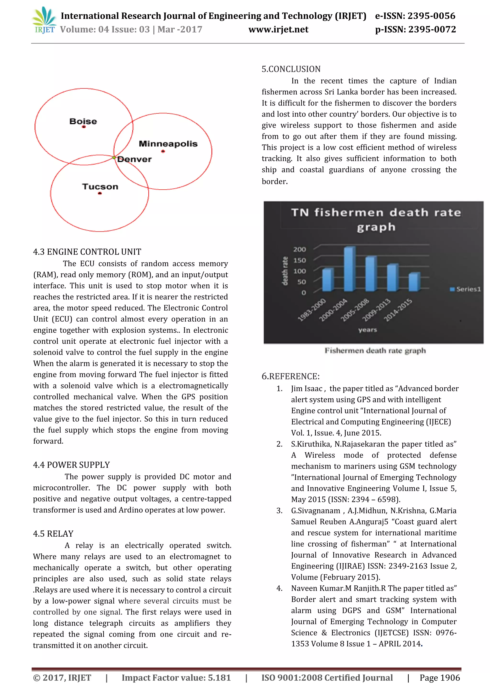


This document describes a border alert system for fishermen using GPS and GSM technology. The system tracks the location of boats using GPS and alerts fishermen with a warning message on an LCD display when they near the border. If the fishermen continue past the border, the system will automatically stop the boat's engine using a relay. The goal is to prevent Indian fishermen from accidentally crossing into Sri Lankan waters and protect their safety. The system components include a GPS module to track location, GSM module to send alerts and location data, microcontroller for processing, engine control unit to stop the engine, and power supply. It provides a low-cost solution to ensure fishermen do not cross maritime borders.


