Download as PDF, PPTX
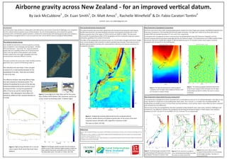

Land Information New Zealand completed the first national airborne gravity survey of New Zealand in collaboration with GNS Science and Victoria University of Wellington. Over 50,000 line-kilometers of data were collected to determine gravity anomalies with 10km spatial resolution. This data was combined with existing terrestrial and satellite data using least squares collocation to produce a new gravimetric quasigeoid model. Validation showed the new model has an accuracy of 3.9cm standard deviation and 4.86cm root mean squared error, an improvement of around 1.5cm over the previous NZGeoid2009 model.


