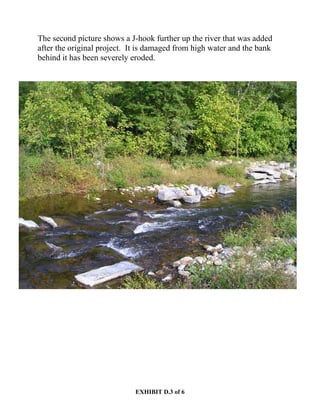
This document discusses issues with using J-hook structures to address erosion problems in streams and rivers. A retired general shares his experience with a similar stream restoration project on the Rapidan River in Virginia. The agencies involved required installing J-hooks without sufficient bank reinforcement. During high water events, the river washed out the banks behind the J-hooks, negating their intended effect. The general believes the J-hooks exacerbated bank erosion by channeling water into the banks. He concludes that without heavy stone riprap reinforcement, stream banks will wash away during high waters, rendering the J-hooks useless.


![EXHIBIT D.1 of 6
MEMO [Reformatted to Simplify Reading]
From: Robert Jenkins Sent: Monday, October 09, 2006 7:21 PM
To: Floyd Aylor
Subject: Stream Restoration
Floyd,
I am sorry it has taken me this long to get back to you on your stream restoration questions. I
have been traveling a lot with my job and wanted to look at the section of the Rapidan [a River
located in North-Central Virginia] again (the river I spoke of when I was in Portland). Just got
that done last weekend. When we worked with all the numerous agencies (including the Army
Corps of Engineers) on the stream restoration project, they insisted on putting in J-hook
structures as a means of slowing down the water during times of high water from heavy rain.
Other restoration techniques used were creating turns in the river where none previously existed
and using "root wads" to reinforce the outer stream banks in the turns. Unfortunately, very little
reinforcement [Riprap] of the river banks was done, even when knowing that the original
problem in this area was erosion and eventual collapse of the river bank that allowed the river to
flood the area and threaten a sizeable bridge there. The J-hooks were built of very large stone
(boulders) in a number of places along the river bank, but without any stone reinforcement
[Riprap] along the stream bank, the river simply washed out the bank behind the J-hook and
nullified any effect it may have had. There is a strong belief that the J-hook exacerbated the
bank erosion by channeling the water against and into the bank. One thing is clear; without
reinforcement [Riprap] with very heavy stone (boulders) the dirt banks, where the J-hooks are
located, will wash away with the first significant high water and render the J-hooks useless. The
section of the Rapidan to which I refer, has river banks, where the J-hooks were, that have been
moved by river erosion as much as 25 yards from where they were originally. I noticed this past
weekend that the project managers have gone back in and reinforced some of the turns in the
river with heavy quarry boulders but there still is not enough reinforcement [Riprap] to stop the
severe bank erosion. Having known of and been familiar with the Rapidan River all of my life, I
seriously doubt that we will ever stabilize the section of the river where this project took place
without a major reinforcement [Riprap] of the river banks with heavy stone or some other
material that is equally erosion resistant--particularly on the outer banks of the turns. (Root wads
help but are not very readily available and tend to not last very long.)
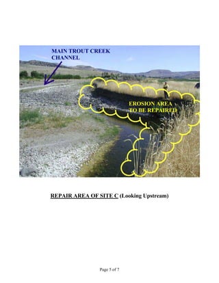
The following pictures [the pictures and corresponding descriptions were moved to the end of
this memo] show the area where the restoration project took place.
I believe these pictures clearly show that most of the original project has been destroyed by high
water primarily because we did not sufficiently reinforce the stream banks to prevent erosion.
If you get back to Virginia any time in the future, I will take you to see this section of the
Rapidan. Hope this helps clarify the discussion we had in Portland in August.
Bob](https://image.slidesharecdn.com/6b94f977-aa55-45d0-a6c0-455ea4b946b3-161221203750/85/PM-10-EXAMPLE-River-Stabilization-Final-Plan-17-320.jpg)