The document summarizes the geology of the Oseberg oilfield in Norway. Four wells were analyzed using well logs to identify geological features like reservoir intervals. A stratigraphic cross-section showed formations thinning from north to south, likely due to uplift. A structural cross-section showed formations intersected at lower depths from north to south, indicating normal faults. Fluid analysis of logs identified oil in most formations except some gas in the Ness Formation. The biggest reservoir is the Drake Formation, which contains oil across the field. Rifting caused multiple faulting that influenced the geology.
This document provides a basic overview of the fundamental rock properties. It delivers a detailed analysis of the basic reservoir rock properties like porosity, permeability, Fluid saturation , wettability, etc.
Clues of a sedimentological model for some oolite reservoirs (example of the ...Prof. Bruno R.C. Granier
Presented on March 17, 1993, on the occasion of the Petroleum Group's meeting: "Carbonate petroleum reservoirs: Models for exploration and development"
The continental crust covers nearly a third of the Earth’s surface, extends vertically from the Earth’s surface to the Moho discontinuity.
It is less dense than oceanic crust.
Compositionally is dominating by silicate elements
Models for the differentiation of the continental crust shows when and how it was formed
Reconciling the sedimentary and igneous records indicates that it may take up to one billion years for a new crust to dominate the sedimentary record.
The continental crust of the Earth differs from the crust of other planets in the Solar System
Its formation modified the composition of the mantle and the atmosphere
It supports life
And it remains a sink for CO2
Evaluating the composition of new continental crust can provide important clues as to how and when it may have been generated. Which is required understanding the differentiation processes of igneous (granites) and sedimentary rocks
Stress analysis is the essence that is needed while planning exploration, drilling and development operations in oil and gas industries. Proper knowledge of Geomechanics will help us to reduce the risk of failure as well as provide a better picture of stresses inside the earth. From Hydrofracturing to directional drilling, stresses play their parts.
Timing of oceans on Mars from shoreline deformationSérgio Sacani
Widespread evidence points to the existence of an ancient Martian
ocean1–8. Most compelling are the putative ancient shorelines in
the northern plains2,7
. However, these shorelines fail to follow
an equipotential surface, and this has been used to challenge the
notion that they formed via an early ocean9
and hence to question
the existence of such an ocean. The shorelines’ deviation from a
constant elevation can be explained by true polar wander occurring
after the formation of Tharsis10, a volcanic province that dominates
the gravity and topography of Mars. However, surface loading from
the oceans can drive polar wander only if Tharsis formed far from
the equator10, and most evidence indicates that Tharsis formed near
the equator11–15, meaning that there is no current explanation for
the shorelines’ deviation from an equipotential that is consistent
with our geophysical understanding of Mars. Here we show that
variations in shoreline topography can be explained by deformation
caused by the emplacement of Tharsis. We find that the shorelines
must have formed before and during the emplacement of Tharsis,
instead of afterwards, as previously assumed. Our results imply that
oceans on Mars formed early, concurrent with the valley networks15,
and point to a close relationship between the evolution of oceans
on Mars and the initiation and decline of Tharsis volcanism, with
broad implications for the geology, hydrological cycle and climate
of early Mars.
Oriented Ice-wedge polygons and oriented deposition Maura Lousada
Ice-wedges were classified by Lachenbruch (1962) into orthogonal and non-orthogonal systems. The main difference is that in in first type, tetravalent vertices predominate over trivalent. Nevertheless, the striking pattern of some networks with oriented polygons has no underlying theory to explain these apparent symmetries. Black (1982) mentions that they could result from the relief in the meanders. Lachenbruch (1962) mentions that they were probably generated by horizontal thermal gradients near the edges of gradually receding bodies of water.
In oriented polygons, the base material , on point bar meanders (soil) has a well-defined lined up layout, according to the water lines that previously have left the deposits in that same area. The main cause for the wedges symmetry may result from the base material settlement orientation. Laboratorial simulations with plastic cracking materials also show results with similar oriented patterns.
Meanders are a typical example of orientated deposition and, all over the Artic were polygonal networks co-exist, the latter present an oriented pattern in its internal bend or depositional areas, coinciding with the point bars orientation. On the other hand, the external curved part of the meanders, where erosion occurs, previous aeolian deposition can be favoured over the fluvial, the patterns are clearly not oriented.
New data on the Hawar, Shu'aiba, Bab, and Sabsab regional stages of the Lower...Prof. Bruno R.C. Granier
Granier B., Busnardo R. & Pittet B. (2009).- New data on the Hawar, Shu'aiba, Bab, and Sabsab regional stages of the Lower Cretaceous in the United Arab Emirates and in Oman. In: Grosheny D. & Granier B. (convs.), Les corrélations plate-forme/bassin.- Volume des Résumés, École des Mines de Paris, November 30th - December 1st, p. 15-17 (abstract).
If you look for more recent publications you will find some slight changes (e.g., the TST of Shu'aiba is ascribed to the Furcata Zone of the "lower Aptian", i.e., the uppermost ammonite zone of the Bedoulian sensu gallico).
Subglacial drainage in porous aquifer and sediment consolidation patterns in the glaciated valley of Andorra (Pyrenees). The poster was presented for the IAG/AIG (International Association of Geomorphologists) Regional Conference on Geomorphology Geodiversity of polar landforms which was held in Longyearbyen (Spitsbergen, Norway) on August 1-5, 2007. Conference was organised on the occasion of the International Polar Year 2007/2008 by the Association of Polish Geomorphologists.
Journal Petroleum Geology. Northern and Central North Sea Aptian sands, lowstand systems tract. Sequence stratigraphy development, Logs and micropapaeontology. prospectivity
Delineation of Hydrocarbon Bearing Reservoirs from Surface Seismic and Well L...IOSR Journals
Hydrocarbon reservoir has been delineated and their boundaries mapped using direct indicators from 3-D seismic and well log data from an oil field in Nembe creek, Niger Delta region. Well log signatures were employed to identify hydrocarbon bearing sands. Well to seismic correlation revealed that these reservoirs tied with direct hydrocarbon indicators on the seismic section. The results of the interpreted well logs revealed that the hydrocarbon interval in the area occurs between 6450ft to 6533ft for well A, 6449ft to 6537ft for well B and 6629ft to 6704ft for well C; which were delineated using the resistivity, water saturation and gamma ray logs. Cross plot analysis was carried out to validate the sensitivity of the rock attributes to reservoir saturation condition. Analysis of the extracted seismic attribute slices revealed HD5000 as hydrocarbon bearing reservoir.
pp395 414 Journal Petroleum Geology10 1987 The Albian transgression in the so...Stephen Crittenden
description of the regional Albian transgression as identified by wireline log, lithostratigraphy and biostratigraphy correlation - England, North Sea, Holland and Germany
Sustained wet–dry cycling on early MarsSérgio Sacani
The presence of perennially wet surface environments on early Mars is well documented1,2, but little is known about short-term episodicity in the early hydroclimate3. Post-depositional processes driven by such short-term fluctuations may produce distinct structures, yet these are rarely preserved in the sedimentary record4. Incomplete geological constraints have led global models of the early Mars water cycle and climate to produce diverging results5,6. Here we report observations by the Curiosity rover at Gale Crater indicating that high-frequency wet–dry cycling occurred in early Martian surface environments. We observe exhumed centimetric polygonal ridges with sulfate enrichments, joined at Y-junctions, that record cracks formed in fresh mud owing to repeated wet–dry cycles of regular intensity. Instead of sporadic hydrological activity induced by impacts or volcanoes5, our findings point to a sustained, cyclic, possibly seasonal, climate on early Mars. Furthermore, as wet–dry cycling can promote prebiotic polymerization7,8, the Gale evaporitic basin may have been particularly conducive to these processes. The observed polygonal patterns are physically and temporally associated with the transition from smectite clays to sulfate-bearing strata, a globally distributed mineral transition1. This indicates that the Noachian–Hesperian transition (3.8–3.6 billion years ago) may have sustained an Earth-like climate regime and surface environments favourable to prebiotic evolution.
Aberdeen Conference in 1999 on the Lower Cretaceous of the North Sea. This talk (abstract) discussed the Lower Cretaceous plays in a sequnce stratigraphy framework. This includes HST and LST and discusses the known hydrocarbon fields in this context.
Petroleum exploration project on the Halfway Formation in the Dimsdale Oil Field, working alongside another student geologist by analyzing the depositional environments, hydrocarbon trapping methods, oil-water contact, well interpretation, basin model building, and volumetric measurements on hydrocarbons.
Distinguishing gas bearing sandstone reservoirs within mixed siliciclastic-ca...Ahmed Hafez
Seismic AVO analysis of the mixed clastics and carbonate sequences to distinguish the gas sandstone in the Nile Delta basin, offshore Mediterranean Sea. Rock physics analysis is also included. Extended elastic impedance inversion also applied. Nile Delta seismic reservoir characterization workflow
If you want to work in my team you can download this MOU and fill in the marked in red and sign it and send it to sigvehamiltonaspelund@gmail.com I will return it with my signature.
Model Attribute Check Company Auto PropertyCeline George
In Odoo, the multi-company feature allows you to manage multiple companies within a single Odoo database instance. Each company can have its own configurations while still sharing common resources such as products, customers, and suppliers.
Embracing GenAI - A Strategic ImperativePeter Windle
Artificial Intelligence (AI) technologies such as Generative AI, Image Generators and Large Language Models have had a dramatic impact on teaching, learning and assessment over the past 18 months. The most immediate threat AI posed was to Academic Integrity with Higher Education Institutes (HEIs) focusing their efforts on combating the use of GenAI in assessment. Guidelines were developed for staff and students, policies put in place too. Innovative educators have forged paths in the use of Generative AI for teaching, learning and assessments leading to pockets of transformation springing up across HEIs, often with little or no top-down guidance, support or direction.
This Gasta posits a strategic approach to integrating AI into HEIs to prepare staff, students and the curriculum for an evolving world and workplace. We will highlight the advantages of working with these technologies beyond the realm of teaching, learning and assessment by considering prompt engineering skills, industry impact, curriculum changes, and the need for staff upskilling. In contrast, not engaging strategically with Generative AI poses risks, including falling behind peers, missed opportunities and failing to ensure our graduates remain employable. The rapid evolution of AI technologies necessitates a proactive and strategic approach if we are to remain relevant.
The Roman Empire A Historical Colossus.pdfkaushalkr1407
The Roman Empire, a vast and enduring power, stands as one of history's most remarkable civilizations, leaving an indelible imprint on the world. It emerged from the Roman Republic, transitioning into an imperial powerhouse under the leadership of Augustus Caesar in 27 BCE. This transformation marked the beginning of an era defined by unprecedented territorial expansion, architectural marvels, and profound cultural influence.
The empire's roots lie in the city of Rome, founded, according to legend, by Romulus in 753 BCE. Over centuries, Rome evolved from a small settlement to a formidable republic, characterized by a complex political system with elected officials and checks on power. However, internal strife, class conflicts, and military ambitions paved the way for the end of the Republic. Julius Caesar’s dictatorship and subsequent assassination in 44 BCE created a power vacuum, leading to a civil war. Octavian, later Augustus, emerged victorious, heralding the Roman Empire’s birth.
Under Augustus, the empire experienced the Pax Romana, a 200-year period of relative peace and stability. Augustus reformed the military, established efficient administrative systems, and initiated grand construction projects. The empire's borders expanded, encompassing territories from Britain to Egypt and from Spain to the Euphrates. Roman legions, renowned for their discipline and engineering prowess, secured and maintained these vast territories, building roads, fortifications, and cities that facilitated control and integration.
The Roman Empire’s society was hierarchical, with a rigid class system. At the top were the patricians, wealthy elites who held significant political power. Below them were the plebeians, free citizens with limited political influence, and the vast numbers of slaves who formed the backbone of the economy. The family unit was central, governed by the paterfamilias, the male head who held absolute authority.
Culturally, the Romans were eclectic, absorbing and adapting elements from the civilizations they encountered, particularly the Greeks. Roman art, literature, and philosophy reflected this synthesis, creating a rich cultural tapestry. Latin, the Roman language, became the lingua franca of the Western world, influencing numerous modern languages.
Roman architecture and engineering achievements were monumental. They perfected the arch, vault, and dome, constructing enduring structures like the Colosseum, Pantheon, and aqueducts. These engineering marvels not only showcased Roman ingenuity but also served practical purposes, from public entertainment to water supply.
How to Make a Field invisible in Odoo 17Celine George
It is possible to hide or invisible some fields in odoo. Commonly using “invisible” attribute in the field definition to invisible the fields. This slide will show how to make a field invisible in odoo 17.
Francesca Gottschalk - How can education support child empowerment.pptxEduSkills OECD
Francesca Gottschalk from the OECD’s Centre for Educational Research and Innovation presents at the Ask an Expert Webinar: How can education support child empowerment?
Biological screening of herbal drugs: Introduction and Need for
Phyto-Pharmacological Screening, New Strategies for evaluating
Natural Products, In vitro evaluation techniques for Antioxidants, Antimicrobial and Anticancer drugs. In vivo evaluation techniques
for Anti-inflammatory, Antiulcer, Anticancer, Wound healing, Antidiabetic, Hepatoprotective, Cardio protective, Diuretics and
Antifertility, Toxicity studies as per OECD guidelines
Instructions for Submissions thorugh G- Classroom.pptxJheel Barad
This presentation provides a briefing on how to upload submissions and documents in Google Classroom. It was prepared as part of an orientation for new Sainik School in-service teacher trainees. As a training officer, my goal is to ensure that you are comfortable and proficient with this essential tool for managing assignments and fostering student engagement.
Instructions for Submissions thorugh G- Classroom.pptx
Oseberg oppgave 1
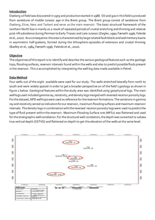
1. Introduction
Oseberg oilfieldwas discovered in 1979 and productionstarted in 1988. Oil and gasin thisfieldis produced
from sandstone of middle Jurassic age in the Brent group. The Brent group consist of sandstone from
Oseberg, Etive, Ness and Tarbert and serve as the main reservoir. The basic structural framework of the
northern North Sea is mainly as a result of repeated periodsof crustal stretching and thinning and relative
post-rift subsidence during Permian to Early Triassic and Late Jurassic (Ziegler, 1990; Færseth 1996; Faleide
et al.,2010). As aconsequence theareaischaracterized bylargerotated fault blocksandsedimentarybasins
in asymmetric half grabens, formed during the lithospheric episodes of extension and crustal thinning
(Badley et al., 1984; Færseth 1996; Faleide et al., 2010).
Objective
The objectivesof thisreport is to identifyand describe thevarious geologicalfeaturessuch as the geologic
tops, flooding surfaces, reservoir intervals found within thewells and also to predict possiblefluids present
in the reservoir. This is accomplished by interpreting the well log data made available in Petrel.
Data Method
Four wells out of the eight available were used for our study. The wells stretched laterally from north to
south and were widely spaced in order to get a broader perspective on of the field’s geology as shown in
figure 1 below. Geological features within the study area was identified using geophysical logs. The main
welllogsused included gammaray,resistivity,and density logsmerged with reversed neutron porositylogs.
Forthedataset,NPDwelltopswere used as reference for thereservoir formations.Thevariations ingamma
rayand resistivityserved as indicatorsforour reservoir, maximum flooding surfaces andmaximum reservoir
intervals. Thedensity logs in combinationwith thereversed neutron porosity logswere used to predict the
type of fluid present within the reservoir. Maximum Flooding Surface one (MFS1) was flattened and used
for thestratigraphicwellcorrelation.For the structural well correlation,thedepth was converted to subsea
true vertical depth (SSTVD) and flattened on depth to get the elevation of the wells at the same level.
2. Fig 1 Map of the field showing selected wells
Fig 1. Stratigraphic Cross Section of the Oseberg Oil Field
3. Fig. 2 Structural Cross Section of the Oseberg Oil Field
Observation
Themaximum flooding surface one (MFS1) from figure 1 was used for thestratigraphiccross section. MFS1
was used for this correlation because it is a widespread deposit s that were easily visible in the log data
across the various wells. It also serves as the genetictime boundary which separates younger strata’s that
forms above it from older ones that forms below in order to bring it to a common datum.
For theStratigraphicCorrelationwhich isshownon Figure 1. One ofthefirst observationswas spotting how
from the stratigraphic cross section, the formation sandstones, maximum flooding surfaces and reservoir
decreases in thickness from wells 30/6-7 located in the northmost part of the field to well 306/1 to 30/6-9
and then down to 30/9-19 which lay southward in that order respectively.
For theStructural well correlationwhich isshown on Figure 2. It can beobserved that the Ness, Etive,Drake
and Cook formation are all intersected at lower depth in well 30/6-1 as compared to well 30/6-7. They are
thenintersected at alowerdepth inwell30/6-9 and inan even lowerdepth inwell30/9-19. It canbeobserved
that theOseberg and Tarbert formationare not present in allthewells. Tarbert formation is present in well
30/6-7 and 30/9-19 and Oseberg formationis onlypresent in well30/6-7. Cookformationis present in allthe
wells but well 30/9-19.
For our fluid presence study, when observing the combined neutron porosity and density logs of the
different formations, we observed various distinctions in the displacement gaps between both logs. We
took notice that in some formations we had close gaps in displacements in between the logs throughout
theformation.Also, in some cases withinthesame formations we hadabiggerdisplacement betweenboth
logs after the formation tops and little of no gaps as it increased in depth and thickness downward.
Interpretation
From the stratigraphic cross section, observations made indicates that the thickness of the various
formations getsthinner inwell 30/6-1 andthenthethickness starts increasing againas it trends towardsthe
south. This was be as a result of tectonic activities possibly uplift which caused the sediments to stretch
resulting in the thinning of its layers in the area were well 30/6-1 is located. It is also possible that
unconformity also set in after the uplift which would explain why the Tarbert formation is only present in
thewells located at thenorthern andsouthern part ofthefieldbut thenabsent from thewells in thecentral
part.
From the structural cross section, it can be observed that all the formations were intercepted at a higher
elevation in well 30/6-1 relative to wells 30/6-7 and 30/6-9. The formations were all intercepted at a much
lower depth in well30/9-19 thanin well30/6-9. Thismight be as a result offault that set in after deposition.
The fault that exist between the two northern most wells might be a reverse fault and the ones that exist
between well 30/6-7 and 30/6-9 and well 30/6-9 and 30/9-19 are normal faults.
From the combined neutron porosity and density it can be interpreted that the fluid that exist in the
Tarbert, Oseberg, Drake, Etive formations are oil. Ness being the exception holds mix of gas and oil with
the formation as it stretches to the various wells.
Conclusion
From the report, it can be concluded that
Drake Formation is our biggest reservoir, it contains oil and can be found though out the various
wells with the field.
Rifting which occurred in theViking basin resulted in multiplefaulting activityoccurring within the
field.