This document analyzes node localization in wireless sensor networks. It compares three range-based localization algorithms (TOA, AOA, RSSI) based on their standard deviation of localization error under varying network parameters. Through simulations, it finds that the TOA algorithm generally provides the lowest error compared to the other two algorithms. Specifically, it finds that standard deviation decreases with increasing network density and anchor node density, but first decreases and then increases with network size. It concludes that the TOA algorithm provides the best accuracy for localization based on its analysis of parameter effects.
Iaetsd improving the location of nodes in wireless adIaetsd Iaetsd
The document proposes an Improvised LAL approach to localize nodes in wireless ad hoc and sensor networks. It aims to identify and convert non-localizable nodes to localizable nodes in a single round. The approach has three main modules: 1) Identifying localizable and non-localizable nodes, 2) Analyzing the network structure using a distance graph, and 3) Making adjustments to distinctively convert non-localizable nodes. Additional techniques like add-heuristic and geographical routing are used. The approach decomposes the distance graph and manages components as a tree to efficiently make adjustments along paths from roots to leaves. This allows all nodes to be localized using standard localization algorithms.
This document summarizes localization algorithms in wireless sensor networks. It discusses how node localization is an important challenge for wireless sensor networks. It reviews different approaches to node localization, including centralized and distributed algorithms. Centralized algorithms migrate data to a central station, while distributed algorithms perform computations locally. Specific algorithms discussed include MDS-MAP, simulated annealing approaches, beacon-based, relaxation-based, and coordinate system stitching approaches. The document also discusses hybrid localization techniques and future challenges in improving localization.
The document presents a localization technique for wireless sensor networks that uses trilateration based on received signal strength. It begins with an introduction to wireless sensor networks and localization. It then discusses related work on trilateration localization techniques. The document proposes a methodology that uses signal propagation models to estimate distances between nodes from received signal strength, and then applies trilateration to compute node positions in 3D space using four or more anchor nodes. It presents simulation results showing the mean square error decreases and localization accuracy increases as the number of anchor nodes increases. The technique provides more accurate localization than existing fuzzy logic approaches, with average localization errors less than 0.5 units when using 100 anchor nodes.
Localization of nodes in an infrastructure less network serves many purposes. Several issues relating to
security, routing, etc it can be solved if only the actual location of nodes were known. Existing approaches
estimate the location of a node in a network by using received signal strength indicator (RSSI), Time of
Arrival, Time difference of Arrival and, if directional antennas are available, Direction of Arrival. In these
methods the localization accuracy is less (in the order of 20cm). The aim of this paper is to localize nodes
in adhoc networks with improved accuracy using ultra wide band.The proposed method uses a train of low
amplitude pulses of high bandwidth, which reduces the energy consumption, effects due to small scale
fading, and dispersion in time and frequency. The network was simulated in NS-2 with UWB extension and
the localization accuracy was found to be improved (upto 1cm).
Optimum Sensor Node Localization in Wireless Sensor Networkspaperpublications3
Abstract: Scientists, engineers, and researchers use wireless sensor networks (WSN) for a wide array of applications. Many of these applications rely on knowledge of the precise position of each node. An optimum localization algorithm can be used for determining the position of nodes in a wireless sensor network. This paper provides an overview of different approach of node localization discovery in wireless sensor networks. The overview of the schemes proposed by different scholars for the improvement of localization in wireless sensor networks is also presented. Experiments were performed in a testbed area containing anchor and blind nodes deployed in it to characterize the pathloss exponent and to determine the localization error of the algorithm. Details regarding the implementation of new algorithm are also discussed in this paper.
This document summarizes research on coverage problems in wireless sensor networks in the presence of obstacles. It begins with definitions of key concepts related to sensor network coverage, including different types of coverage problems (point, area, barrier), deployment strategies (deterministic, random), coverage degrees, sensing models, and obstacles. It then reviews several approaches that have been proposed to address coverage problems when obstacles are present in the sensor field, including using computational geometry concepts to handle obstacles. The document concludes by noting that more work is still needed to fully address coverage problems in realistic environments with obstacles.
As Wireless Sensor Networks are penetrating into the industrial domain, many research opportunities are emerging. One such essential and challenging application is that of node localization. A feed-forward neural network based methodology is adopted in this paper. The Received Signal Strength Indicator (RSSI) values of the anchor node beacons are used. The number of anchor nodes and their configurations has an impact on the accuracy of the localization system, which is also addressed in this paper. Five different training algorithms are evaluated to find the training algorithm that gives the best result. The multi-layer Perceptron (MLP) neural network model was trained using Matlab. In order to evaluate the performance of the proposed method in real time, the model obtained was then implemented on the Arduino microcontroller. With four anchor nodes, an average 2D localization error of 0.2953 m has been achieved with a 12-12-2 neural network structure. The proposed method can also be implemented on any other embedded microcontroller system.
11.0005www.iiste.org call for paper.a robust frame of wsn utilizing localizat...Alexander Decker
This document discusses localization techniques for wireless sensor networks. It begins by defining localization as identifying a sensor node's position and explains how accuracy is important. It then describes two main categories of localization techniques: range-based and range-free. Range-based uses distance or angle measurements between nodes for higher accuracy but requires expensive hardware. Range-free relies on information from nearby nodes and is less accurate but cheaper. The document reviews several specific localization algorithms from previous research and their limitations. It concludes by stating that energy efficiency is critical for wireless sensor networks due to limited battery life.
5.a robust frame of wsn utilizing localization technique 36-46Alexander Decker
This document discusses localization techniques for wireless sensor networks. It begins by defining localization as identifying a sensor node's position and explains that localization is a fundamental challenge for wireless sensor networks. It then describes two main categories of localization techniques: range-based and range-free. Range-based techniques use distance or angle measurements between nodes to determine positions but require expensive hardware. Range-free techniques estimate positions based on neighboring node information and are less expensive but less accurate. The document reviews several specific localization algorithms from previous research and discusses their advantages and limitations.
A HYBRID FUZZY SYSTEM BASED COOPERATIVE SCALABLE AND SECURED LOCALIZATION SCH...ijwmn
Localization entails position estimation of sensor nodes by employing different techniques and mathematical computations. Localizable sensors also form an inherent part in the functioning of IoT devices and robotics. In this article, the author extends1 a novel scheme for node localization implemented using a hybrid fuzzy logic system to trace the node locations inside the deployment region, presented by the
Abhishek Kumar et. al. The results obtained were then optimized using Gauss Newton Optimization to improve the localization accuracy by 50% to 90% vis-à-vis weighted centroid and other fuzzy based localization algorithms. This article attempts to scale the proposed scheme for large number of sensor nodes to emulate somewhat real world scenario by introducing cooperative localization in previous presented work. The study also analyses the effectiveness of such scaling by comparing the localization accuracy. In next section, the article incorporates security in the proposed cooperative localization approach to detect malicious nodes/anchors by mutual authentication using El Gamel digital Signature scheme. A detailed study of the impact of incorporating security and scaling on average processing time and localization coverage has also been performed. The processing time increased by a factor of 2.5s for 500 nodes (can be attributed to more number of iterations and computations and large deployment area with small radio range of nodes) and coverage remained almost equal, albeit slightly low by a factor of 1% to 2%. Apart from these, the article also discusses the impact of adding extra functionalities in the proposed hybrid fuzzy system based localization scheme on processing time and localization accuracy.Lastly, this study also briefs about how the proposed scalable, cooperative and secure localization scheme tackles the type of attacks that pose threat to localization.
Effective range free localization scheme for wireless sensor networkijmnct
Location aware sensors can be used in many areas such as military and civilian applications. Wireless
Sensor Networks help to identify the accurate location of the event. In this paper a cost effective schema for
localization has been proposed. It uses two beacon nodes to identify the location of unknown nodes. It
also uses flooding and estimating method to accurately identify the location of other nodes. Available area
is divided into zones and beacons are provided for each zone. Beacon nodes are placed in appropriate
locations normally two in a zone to provide location information. Using the two nodes location of unknown
nodes can be calculated accurately.
Performance of energy balanced territorial predator scent marking algorithm b...eSAT Publishing House
IJRET : International Journal of Research in Engineering and Technology is an international peer reviewed, online journal published by eSAT Publishing House for the enhancement of research in various disciplines of Engineering and Technology. The aim and scope of the journal is to provide an academic medium and an important reference for the advancement and dissemination of research results that support high-level learning, teaching and research in the fields of Engineering and Technology. We bring together Scientists, Academician, Field Engineers, Scholars and Students of related fields of Engineering and Technology
International Journal of Engineering Research and Development (IJERD)IJERD Editor
This document summarizes research on detecting sensor node failures and proposing a node scheduling scheme in wireless sensor networks. It first introduces wireless sensor networks and discusses common node failures that can occur. It then proposes three algorithms: 1) using neighborhood keys and testing procedures to detect node failures, 2) implementing a security-aware routing protocol to provide security, and 3) developing an adaptive node scheduling method to maintain sensing levels when nodes fail. The document evaluates these approaches and concludes they can help address problems of node failure detection, security, and maintaining network functionality.
This document summarizes a research paper that proposes the design and implementation of an intelligent laser warning system using fuzzy logic. The system uses four laser sensors to detect the incident laser angle from 0 to 360 degrees and an additional sensor to distinguish the laser from background sunlight. A fuzzy logic algorithm is used to fuse the sensor data and estimate the angle of incidence. The system is first simulated in MATLAB and then implemented using a TI-430 microcontroller. The goal is to develop a low-cost laser detection system that can accurately detect laser threats and distinguish them from other light sources like the sun.
Key Management Schemes for Secure Communication in Heterogeneous Sensor NetworksIDES Editor
Hierarchical Sensor Network organization is
widely used to achieve energy efficiency in Wireless Sensor
Networks(WSN). To achieve security in hierarchical WSN,
it is important to be able to encrypt the messages sent
between sensor nodes and its cluster head. The key
management task is challenging due to resource constrained
nature of WSN. In this paper we are proposing two key
management schemes for hierarchical networks which
handles various events like node addition, node compromise
and key refresh at regular intervals. The Tree-Based
Scheme ensures in-network processing by maintaining some
additional intermediate keys. Whereas the CRT-Based
Scheme performs the key management with minimum
communication and storage at each node.
The Design A Fuzzy System in Order to Schedule Sleep and Waking Of Sensors in...IJERA Editor
Sensor networks are considered to be a standard technology in wireless communications and they are widely
used in military, surveillance, medicine, industry and houses as well. In sensor networks batteries with limited
amount of energy provide energy for the whole system. They are not rechargeable and as soon as the batteries
die the network life time will expire too. Using computational intelligence to schedule sleep and waking of the
sensor nodes is one of the suitable methods which helps the network to have a longer life. In this paper the focus
is on a fuzzy method to schedule sleeping and waking of sensor nodes. In this method the Environmental
conditions of each sensor (the number of neighbors, the remaining energy, and the distance to the next cluster
node) are considered as inputs by the application of a fuzzy system based on which the system creates an output
and the sleeping and waking time of each sensor is dynamically determined. The simulated results show that the
proposed algorithm is more efficient than other basic methods and consume less energy as well.
Secure and efficient key pre distribution schemes for wsn using combinatorial...eSAT Publishing House
IJRET : International Journal of Research in Engineering and Technology is an international peer reviewed, online journal published by eSAT Publishing House for the enhancement of research in various disciplines of Engineering and Technology. The aim and scope of the journal is to provide an academic medium and an important reference for the advancement and dissemination of research results that support high-level learning, teaching and research in the fields of Engineering and Technology. We bring together Scientists, Academician, Field Engineers, Scholars and Students of related fields of Engineering and Technology
Wireless Sensor Network using Particle Swarm Optimizationidescitation
Wireless sensor network (WSN) is becoming
progressively important and challenging research area. A
Wireless sensor network (WSN) consists of spatially
distributed autonomous sensors to monitor physical and
environmental conditions and to co-operatively pass their data
through the network to a main location. Wireless sensor
consists of small low cost sensor nodes, having a limited
transmission range and their processing, storage capabilities
and energy resources are limited. The main task of such a
network is to gather information from a node and transmit it
to a base station for further processing.WSN has different
issues such as optimal sensor deployment, node localization,
base station placement, location of target nodes, energy aware
clustering and data aggregation. Recently researchers around
the world are applying bio-inspired optimization algorithm
known as particle swarm optimization (PSO) for increasing
efficiency in the WSN issues. This paper describes the use of
PSO algorithm for optimal sensor deployment in WSN.
This document summarizes research on algorithms for proximity estimation in sensor networks. It discusses using sensor networks to detect events observed by nodes within a certain distance of each other. It proposes an algorithm that utilizes a distributed routing index maintained by nodes in the network to process multiple proximity queries involving different event types. The document reviews several related works on localization algorithms, data-centric sensor networks, geographic routing protocols, and node localization techniques. It evaluates different wireless sensor network simulators and deployment schemes.
Fault Diagonosis Approach for WSN using Normal Bias TechniqueIDES Editor
In wireless sensor and actor networks (WSAN), the
sensor nodes have a limitation on lifetime as they are equipped
with non-chargeable batteries. The failure probability of the
sensor node is influenced by factors like electrical dynamism,
hardware disasters, communication inaccuracy and undesired
environment situations, etc. Thus, fault tolerant is a very
important and critical factor in such networks. Fault tolerance
also ensures that a system is available for use without any
interruption in the presence of faults. In this paper an
improved fault tolerance scheme is proposed to find the
probability of correctly identifying a faulty node for three
different types of faults based on normal bias. The nodes fault
status is declared based on its confidence score that depends
on the threshold valve. The aim is to find the Correct
Recognition Rate (CRR) and the False Fear Rate (FFR) with
respect to the different error probability (pe) introduced. The
techniques, neighboring nodes, fault calculations, range and
CRR for existing algorithm and proposed algorithm is also
presented.
A CUSTOMIZED FLOCKING ALGORITHM FOR SWARMS OF SENSORS TRACKING A SWARM OF TAR...csandit
Wireless mobile sensor networks (WMSNs) are groups of mobile sensing agents with multimodal
sensing capabilities that communicate over wireless networks. WMSNs have more
flexibility in terms of deployment and exploration abilities over static sensor networks. Sensor
networks have a wide range of applications in security and surveillance systems, environmental
monitoring, data gathering for network-centric healthcare systems, monitoring seismic activities
and atmospheric events, tracking traffic congestion and air pollution levels, localization of
autonomous vehicles in intelligent transportation systems, and detecting failures of sensing,
storage, and switching components of smart grids.
This document summarizes an academic paper that proposes a new Energy Minimized Opportunistic Routing (EMOR) protocol for wireless sensor networks. EMOR aims to enhance source location privacy and minimize energy usage. It uses opportunistic routing to dynamically change paths from source to destination, hiding the source location. Additionally, EMOR reduces transmission power of each node to minimize energy consumption while still reliably transmitting packets. The paper reviews related work on source privacy and energy efficiency in wireless routing protocols and presents simulation results showing EMOR provides better source privacy compared to existing opportunistic routing while also reducing energy usage.
International Journal of Engineering Research and Applications (IJERA) is an open access online peer reviewed international journal that publishes research and review articles in the fields of Computer Science, Neural Networks, Electrical Engineering, Software Engineering, Information Technology, Mechanical Engineering, Chemical Engineering, Plastic Engineering, Food Technology, Textile Engineering, Nano Technology & science, Power Electronics, Electronics & Communication Engineering, Computational mathematics, Image processing, Civil Engineering, Structural Engineering, Environmental Engineering, VLSI Testing & Low Power VLSI Design etc.
A Fault tolerant system based on Genetic Algorithm for Target Tracking in Wir...Editor IJCATR
In this paper, we explored the possibility of using Genetic Algorithm (GA) being used in Wireless Sensor Networks in general with
specific emphasize on Fault tolerance. In Wireless sensor networks, usually sensor and sink nodes are separated by long communication
distance and hence to optimize the energy, we are using clustering approach. Here we are employing improved K-means clustering algorithm to
form the cluster and GA to find optimal use of sensor nodes and recover from fault as quickly as possible so that target detection won’t be
disrupted. This technique is simulated using Matlab software to check energy consumption and lifetime of the network. Based on the
simulation results, we concluded that this model shows significant improvement in energy consumption rate and network lifetime than other
method such as Traditional clustering or Simulated Annealing
This document describes an RSSI (received signal strength indicator) based localization algorithm for wireless sensor networks. It discusses using RSSI values measured from reference nodes to estimate distances and perform trilateration to locate a target sensor node. The algorithm design includes RSSI to distance conversion using a path loss model, trilateration implementation using circle intersections, and simplifying computations for resource-limited sensor node processors through techniques like Taylor series approximations of exponential functions. Pseudocode is provided for RSSI to distance conversion and trilateration calculations.
Toward accurate mobile sensor network localization in noisy environmentsJPINFOTECH JAYAPRAKASH
The document proposes a fuzzy logic-based approach for mobile node localization in challenging indoor and mobile environments characterized by high radio signal irregularity. It develops a fuzzy multilateration module and fuzzy inference module to obtain a node's location from noisy RSS measurements. Extensive simulation results show improvements in localization accuracy from 20 to 40 percent when radio irregularity is high, outperforming state-of-the-art solutions. A hardware implementation on motes transported by robots confirms the simulation results in real-world testing.
Neural Network Algorithm for Radar Signal RecognitionIJERA Editor
Nowadays, the traditional recognition method could not match the development of radar signals. In this paper, based on fractal theory and Neural Network, a new radar signal recognition algorithm is presented. The relevant point is extracted as the input of neutral network, and then it will recognize and classify the signals. Simulation results show that, this algorithm has a distinguish effect on classification under the condition of low SNR.
EFFECTIVE AND SECURE DATA COMMUNICATION IN WSNs CONSIDERING TRANSFER MODULE O...IJEEE
A Bio-inspired clustering algorithm based on BFO has been proposed and investigation on energy efficient clustering algorithms related to WSNs has been done in this paper. The contribution of this paper related to use of Bacteria foraging algorithm firstly for WSNs for enhancing network lifetime of sensor nodes.
Rocker arms are part of the valve-actuating mechanism. A rocker arm is designed to pivot on a pivot
pin or shaft that is secured to a bracket. The bracket is mounted on the cylinder head. One end of a
rocker arm is in contact with the top of the valve stem, and the other end is actuated by the camshaft.
In installations where the camshaft is located below the cylinder head, the rocker arms
are actuated by pushrods. The lifters have rollers which are forced by the valve springs to follow the
profiles of the cams. Failure of rocker arm is a measure concern as it is one of the important
components of push rod IC engines.Present work finds the various stresses under extreme load
condition. For this we are modeling the arm using design software and the stressed regions are
found out usingAnsys software. Here in this thesis we are observing that by changing different
materials how the stresses are varying in the rocker arm under extreme load condition. And after
comparing results we are proposing best suitable material for the rocker arm under extreme load conditions.
Development of a Cassava Starch Extraction Machineijceronline
International Journal of Computational Engineering Research(IJCER) is an intentional online Journal in English monthly publishing journal. This Journal publish original research work that contributes significantly to further the scientific knowledge in engineering and Technology.
Strong (Weak) Triple Connected Domination Number of a Fuzzy Graphijceronline
International Journal of Computational Engineering Research(IJCER) is an intentional online Journal in English monthly publishing journal. This Journal publish original research work that contributes significantly to further the scientific knowledge in engineering and Technology.
The Myth of Softening behavior of the Cohesive Zone Model Exact derivation of...ijceronline
International Journal of Computational Engineering Research(IJCER) is an intentional online Journal in English monthly publishing journal. This Journal publish original research work that contributes significantly to further the scientific knowledge in engineering and Technology.
Engendering sustainable socio-spatial environment for tourism activities in t...ijceronline
The document summarizes a study that assessed the potential for knitting together the five states of South-Eastern Nigeria into a unified tourist destination of international significance. It identifies various tourism potentials across the region and evaluates the accessibility between state capitals. The study recommends adopting an Environmental Planning and Management process involving zonal, state, and local forums to coordinate development efforts and achieve a sustainable tourism environment across the region through public-private collaboration. This participatory approach aims to improve infrastructure like roads, airports, utilities and encourage private investment in tourism facilities.
Stress Analysis of a Centrifugal Supercharger Impeller Bladeijceronline
A supercharger is an air compressor that increases the pressure or density of air supplied to an internal combustion engine. This gives each intake cycle of the engine more oxygen, letting it burn
more fuel and do more work, thus increasing power. Power for the supercharger can be provided mechanically by means of a belt, gear, shaft, or chain connected to the engine's crankshaft. Superchargers are a type of forced induction system. They compress the air flowing into the engine.
The advantage of compressing the air is that it lets the engine squeeze more air into a cylinder, and more air means that more fuel can be added. Therefore, you get more power from each explosion in each cylinder. Here in this project we are designing the compressor wheel by using Pro-E and doing
analysis by using FEA package. An attempt has been made to investigate the effect of pressure and induced stresses on the blade. By identifying the true design feature, the extended service life and long term stability is assured. A
structural analysis has been carried out to investigate the stresses, strains and displacements of the blade. An attempt is also made to suggest the best material for an blade of a turbocharger by comparing the results obtained for different materials. Based on the results best material is recommended for the blade of a turbocharger
10 Insightful Quotes On Designing A Better Customer ExperienceYuan Wang
In an ever-changing landscape of one digital disruption after another, companies and organisations are looking for new ways to understand their target markets and engage them better. Increasingly they invest in user experience (UX) and customer experience design (CX) capabilities by working with a specialist UX agency or developing their own UX lab. Some UX practitioners are touting leaner and faster ways of developing customer-centric products and services, via methodologies such as guerilla research, rapid prototyping and Agile UX. Others seek innovation and fulfilment by spending more time in research, being more inclusive, and designing for social goods.
Experience is more than just an interface. It is a relationship, as well as a series of touch points between your brand and your customer. Here are our top 10 highlights and takeaways from the recent UX Australia conference to help you transform your customer experience design.
For full article, continue reading at https://yump.com.au/10-ways-supercharge-customer-experience-design/
How to Build a Dynamic Social Media PlanPost Planner
Stop guessing and wasting your time on networks and strategies that don’t work!
Join Rebekah Radice and Katie Lance to learn how to optimize your social networks, the best kept secrets for hot content, top time management tools, and much more!
Watch the replay here: bit.ly/socialmedia-plan
http://inarocket.com
Learn BEM fundamentals as fast as possible. What is BEM (Block, element, modifier), BEM syntax, how it works with a real example, etc.
The document discusses how personalization and dynamic content are becoming increasingly important on websites. It notes that 52% of marketers see content personalization as critical and 75% of consumers like it when brands personalize their content. However, personalization can create issues for search engine optimization as dynamic URLs and content are more difficult for search engines to index than static pages. The document provides tips for SEOs to help address these personalization and SEO challenges, such as using static URLs when possible and submitting accurate sitemaps.
3D Localization Algorithms for Wireless Sensor NetworksIOSR Journals
This document discusses localization algorithms for 3D wireless sensor networks. It begins by explaining that localization in 3D spaces poses unique challenges compared to 2D, as strategies used in 2D do not directly extend to 3D. It then reviews common range-based localization methods like received signal strength and time-based methods, as well as range-free methods like centroid and DV-HOP algorithms. The document aims to address the problem of localization for sensor networks deployed in 3D surfaces.
The Key Metric forEvaluation Localizationin Wireless Sensor Networks via Dist...CSEIJJournal
Wireless sensor network localization is an importantarea that attracted significant research interest..
Hence, localization schemes for wireless sensorAlthough mobility would appear to make localization more
difficult, in this paper We present a new method bywhich a sensor node can determine its location by
listening to wireless transmissions from three or more fixed beacon nodes and argue that it can exploit
mobility to improve the accuracy and precision of localization. Our approach does not require additional
hardware on the nodes and works even when the movement of seeds and nodes is uncontrollable. The
proposed method is based on aDistance/ Angle- Estimation technique that does not increase the complexity
or cost of construction of the localization sensor nodes. It determines how the available information will be
manipulated to enable all of the nodes of the WSN to estimate their positions. It is a distributed and usually
multi-hop algorithm
A NOVEL APPROACH TO DETECT THE MOVEMENT OF TARGET IN WIRELESS SENSOR NETWORKSEditor IJMTER
The document summarizes a novel approach to detect target movement in wireless sensor networks. It proposes a prediction-based target tracking and sleep scheduling protocol (PPSS) to improve energy efficiency. The protocol reduces actively awakened nodes and controls their active time. It uses a related neighborhood graph to divide the area into non-overlapping faces for target tracking. An edge detection algorithm identifies polygon locations and wakes nodes before a target crosses to continuously monitor mobile targets. The approach achieves high tracking accuracy while reducing energy costs in wireless sensor networks.
Iaetsd a survey on geographic routing relay selection inIaetsd Iaetsd
The document summarizes research on geographic routing and relay selection in wireless sensor networks. It discusses how geographic routing uses location information to route packets towards a destination but faces challenges around connectivity holes and optimal relay selection. The document reviews several existing approaches and their limitations. It then describes an alternative method called ALBA-R that was proposed to more efficiently route around holes while enhancing relay selection to maximize node lifetime. Simulation results showed ALBA-R outperformed other methods with respect to metrics like overhead and end-to-end delay.
UWB LOCALIZATION OF NODES FOR SECURING A MANETijistjournal
Localization of nodes in an infrastructure less network serves many purposes. Several issues relating to security, routing, etc it can be solved if only the actual location of nodes were known. Existing approaches estimate the location of a node in a network by using received signal strength indicator (RSSI), Time of Arrival, Time difference of Arrival and, if directional antennas are available, Direction of Arrival. In these methods the localization accuracy is less (in the order of 20cm). The aim of this paper is to localize nodes in adhoc networks with improved accuracy using ultra wide band.The proposed method uses a train of low amplitude pulses of high bandwidth, which reduces the energy consumption, effects due to small scale fading, and dispersion in time and frequency. The network was simulated in NS-2 with UWB extension and the localization accuracy was found to be improved (upto 1cm).
This document discusses the minimum cost localization problem in wireless sensor networks. The problem aims to localize all sensors in a network using the minimum number or total cost of anchor nodes given distance measurements between nodes. Existing localization methods try to localize as many nodes as possible without guaranteeing all can be localized and assume enough anchor nodes are available. The proposed system detects wheel structures to identify more localizable nodes than simple trilateration, but the document notes there is a counter-example where nodes in a wheel structure cannot be uniquely localized due to a possible flip.
The document proposes a new localization method called A2L (Angle to Landmark) for wireless sensor networks. A2L uses angle of arrival measurements between sensor nodes and a subset of nodes equipped with GPS (landmarks) to determine the positions of non-landmark nodes. Compared to previous methods like APS and AHLoS that also use angle and distance measurements, simulations show that A2L can locate a greater number of nodes with higher accuracy while requiring fewer connections between nodes. The method is also low-cost since it does not require each node to have GPS or other expensive equipment.
The Expansion of 3D wireless sensor network Bumps localizationIJERA Editor
Bump localization of wireless sensor network is a hot topic, but present algorithms of 3D wireless sensor node localization arenot accurate enough. In this paper, the DR-MDS algorithm is proposed, DR-MDS algorithm mainly calibrates the coordinatesof nodes and the ranging of nodes based on multidimensional scaling, it calculates the distance between any nodes exactlyaccording to the hexahedral measurement, introducing a modification factor to calibrate the measuring distance by ReceivedSignal Strength Indicator (RSSI). Results of simulation show that DR-MDS algorithm has significant improvement inlocalization accuracy compare with MDS-MAP algorithm.
LOCALIZATION ALGORITHM USING VARYING SPEED MOBILE SINK FOR WIRELESS SENSOR NE...ijasuc
Localization of sensor nodes is important in many aspects in wireless sensor networks. The known
location of sensor node helps in determining the event of interest. A mobile sink is introduced to track the
event driven sensor nodes in the path of the event, thus conserving energy and time. We present a novel
range based localization algorithm which helps the mobile sink to compute the location of the sensor
nodes efficiently. The data transfer from the mobile sink and the sensor nodes is used to estimate the
sensor location. The sensor nodes do not need to spend energy on neighbouring interaction for
localization. The localization mechanism has been implemented in TOSSIM. The simulation results show
that our scheme performed better than other range-based schemes.
This document summarizes a research paper that proposes a new cuboid-based localization algorithm for wireless sensor networks. The algorithm aims to minimize localization error and decrease energy consumption by shifting complexity to anchor nodes that have GPS. It works by having anchor nodes broadcast their locations to form triangles around unknown nodes. Distances from unknown nodes to anchors are estimated using RSSI. The algorithm is simulated in a 3D space and shows decreasing localization error as the number of anchor nodes increases, achieving an error of under 1.6m. The paper aims to improve over existing localization methods that have issues like multipath interference affecting RSSI-based techniques.
Redundant Actor Based Multi-Hole Healing System for Mobile Sensor NetworksEditor IJCATR
In recent years, the Mobile Wireless Sensor Network
is the emerging solution for monitoring of a specified region of
interest. Several anomalies can occur in WSNs that impair their
desired functionalities resulting in the formation of different
kinds of holes, namely: coverage holes, routing holes. Our
ultimate aim is to cover total area without coverage hole in
wireless sensor networks. We propose a comprehensive solution,
called holes detection and healing. We divided our proposed
work into two phases. The first phase consists of three sub- tasks;
Hole-identification, Hole-discovery and border detection. The
second phase treats the Hole-healing with novel concept, hole
healing area. It consists of two sub-tasks; Hole healing area
determination and node relocation.
International Journal of Engineering Research and Applications (IJERA) is an open access online peer reviewed international journal that publishes research and review articles in the fields of Computer Science, Neural Networks, Electrical Engineering, Software Engineering, Information Technology, Mechanical Engineering, Chemical Engineering, Plastic Engineering, Food Technology, Textile Engineering, Nano Technology & science, Power Electronics, Electronics & Communication Engineering, Computational mathematics, Image processing, Civil Engineering, Structural Engineering, Environmental Engineering, VLSI Testing & Low Power VLSI Design etc.
Node Deployment in Homogeneous and Heterogeneous Wireless Sensor NetworkIJMTST Journal
Optimal sensor deployment is necessary condition in homogeneous and heterogeneous wireless sensor
network. Effective deployment of sensor nodes is a major point of concern as performance and lifetime of any
WSN. Proposed sensor deployment in WSN explore every sensor node sends its data to the nearest sink node
of the WSN. In addition to that system proposes a hexagonal cell based sensor deployment which leads to
optimal sensor deployment for both homogeneous and heterogeneous sensor deployment. Wireless sensor
networks are receiving significant concentration due to their potential applications ranging from surveillance
to tracking domains. In limited communication range, a WSN is divided into several disconnected sub-graphs
under certain conditions. We deploy sensor nodes at random locations so that it improves performance of the
network.This paper aims to study, discuss and analyze various node deployment strategies and coverage
problems for Homogeneous and Heterogeneous WSN.
This document discusses localization techniques for wireless sensor networks. It begins by introducing the importance of localization for applications involving search and rescue operations. It then reviews existing localization approaches, distinguishing between range-free methods that rely on connectivity information and range-based methods that use distance measurements. The document proposes a new algorithm for 3D localization in wireless sensor networks that combines both range-free and range-based approaches to achieve high accuracy localization, important for applications involving human lives. It describes the steps of the proposed algorithm and how it bounds the location of sensor nodes within rectangular regions to narrow down possible positions.
Range Free Localization using Expected Hop Progress in Wireless Sensor NetworkAM Publications
Wireless sensor network (WSN) combines the concept of wireless network with sensors. Wireless Sensor Networks
have been proposed for a multitude of location-dependent applications. Localization (location estimation) capability is
essential in most wireless sensor network applications. In environmental monitoring applications such as animal habitat
monitoring, bush fire surveillance, water quality monitoring and precision agriculture, the measurement data are
meaningless without an accurate knowledge of the location from where the data are obtained. Finding position without the
aid of GPS in each node of an ad hoc network is important in cases where GPS is either not accessible, or not practical to use
due to power, form factor or line of sight conditions. So here we are going to used DV-Hop algorithm, i.e. distance vector
routing algorithm for finding the position of sensor. Here we summarizes the performance evaluation criteria of the
wireless sensor network and algorithms, classification methods, and highlights the principles and characteristics of the
algorithm and system representative of the field in recent years, and several algorithms simulation and analysis.
Development and performance evaluation of localization algorithm for variety ...eSAT Journals
Abstract Wireless sensor networks have emerged from military needs and found its way into civil applications. Today wireless sensor networks have become a key technology for different kinds of smart environments. Sensor node localization which is determining where a given sensor node is physically or relatively located is extremely crucial for most of the applications in wireless sensor networks. The procedure through which the sensor nodes obtain their positions is called localization. Many localization algorithms have been proposed for wireless sensor networks. In this article, we describe our newly developed localization algorithm and performance evaluation of this localization algorithm with square, ‘C’ and ‘L’ shape network topology. Keywords- sensor network, localization algorithms
IJRET : International Journal of Research in Engineering and Technology is an international peer reviewed, online journal published by eSAT Publishing House for the enhancement of research in various disciplines of Engineering and Technology. The aim and scope of the journal is to provide an academic medium and an important reference for the advancement and dissemination of research results that support high-level learning, teaching and research in the fields of Engineering and Technology. We bring together Scientists, Academician, Field Engineers, Scholars and Students of related fields of Engineering and Technology
A Novel Three-Dimensional Adaptive Localization (T-Dial) Algorithm for Wirele...iosrjce
The document presents a novel three-dimensional adaptive localization (T-Dial) algorithm for wireless sensor networks. The proposed algorithm works in four primary phases: 1) Neighbor formation where nodes broadcast information to nodes within transmission range to form neighbor tables; 2) Group formation where anchor nodes connect to non-anchor nodes to divide the network into smaller manageable groups; 3) Edge node marking where edge nodes on the network boundary are detected and marked; and 4) Localization error correction where missing nodes from initial setup are rediscovered and corrected. Simulation results show the proposed algorithm improves localization rate, reduces localization error, and increases positioning rate compared to existing algorithms.
The document presents a novel three-dimensional adaptive localization (T-Dial) algorithm for wireless sensor networks. The proposed algorithm works in four primary phases: 1) Neighbor formation where nodes broadcast information to nodes within transmission range to form neighbor tables; 2) Group formation where anchor nodes connect to nearby nodes to divide the network into manageable groups; 3) Edge node marking where edge nodes on the network boundary are detected and marked; and 4) Localization error correction where missing nodes from initial setup are rediscovered and corrected. Simulation results show the proposed algorithm improves localization rate, reduces localization error, and increases positioning rate compared to existing algorithms.
This document summarizes positioning techniques for wireless sensor networks (WSNs) and Internet of Things (IoT) systems. It discusses both range-based and range-free localization methods. Range-based methods use distance or angle measurements between sensor nodes, including received signal strength indication (RSSI), time of arrival (TOA), time difference of arrival (TDOA), and angle of arrival (AOA). Range-free methods depend on node connectivity and do not require specialized hardware. The document reviews several algorithms and techniques for each category.
1. International Journal Of Computational Engineering Research (ijceronline.com) Vol. 2 Issue.6
Analysis of Node Localization in Wireless Sensor Networks
Sheshmani Yadav1, Dr.D.B.Ojha2, Vijendra Rai3
1
M.Tech, EC Department, Mewar University Chittorgarh, Rajasthan, INDIA
2
Professor, Science Department, Mewar University Chittorgarh, Rajasthan, INDIA
3
Asstt. Prof., CSE Department, College of Engineering & Rural Technology, Meerut, U.P., INDIA
1. Abstract
Sensor networks are dense wireless networks of small, low-cost sensors, which collect and disseminate
environmental data. Sensor nodes are very small, lightweight, and unobtrusive. The problem of localization, that is,
“determining where a given node is physically located in a network”, can be mainly divided into two parts range-based
(fine-grained) or range-free (coarse-grained) schemes. This Paper presents the analysis of range based algorithms on the
basis of few network parameters (Network Size, Anchor node Density, Array node density) and tried to find out the best
range based algorithms by doing simulation on matlab. The metric selected for the analysis is Standard Deviation of
localization error.
Keywords: Localization, Range based schemes, Wireless Sensor Networks.
1. Introduction
1.1 Sensor Network
Recent technological improvements have made the deployment of small, inexpensive, low-power, distributed
devices, which are capable of local processing and wireless communication. Such nodes are called as sensor nodes. Each node
consists of processing capability (one or more micro controllers, CPUs or DSP chips), may contains multiple types of memory
(program, data and flash memories), have a RF transceiver (usually with a single Omni- directional antenna), have a power
source (e.g., batteries and solar cells), and accommodate various sensors and actuators. Sensor nodes have the ability to measure
a given physical environment i.e. pressure, temperature, moister etc in great detail. The nodes communicate wirelessly and often
self-organize after being deployed in an ad hoc fashion.
Thus, a sensor network can be described as a collection of sensor nodes which co-ordinate to perform some specific action. It
facilitates monitoring and controlling of physical environments from remote locations with bett er a ccura cy
They have applications in a variety of fields such as environmental monitoring, military purposes, health monitoring, home
applications and gathering sensing information in inhospitable locations.
Unlike traditional networks, sensor networks depend on dense deployment and co-ordination to carry out their tasks.
1.2 Localization
In sensor networks, nodes are deployed into an unplanned infrastructure where there is no a priori knowledge of
location. “The problem of estimating spatial-coordinates of the sensor node is referred as localization.” OR “It is the process of
assigning or computing the location of the sensor nodes in a sensor network”.
Solving the localization problem is crucial, and some where it is absolutely necessary such as in the case of:
Efficient Targeting: When sensors are aware of their location, they can either trigger the partial silencing when activities that
have to be measured are not present or the activation of some parts of the network when they are detected.
Target Tracking: When the purpose of the network is to track (possibly moving) targets in its deployment area, node
localization is absolutely necessary, especially when the network must be able to restructure itself, or to adapt to node failures,
target movements or security breaches.
Self-Deployment: When mobile nodes are considered, the network can use algorithms to maximize its coverage of the
deployment area, while ensuring the robustness of its communication network. In such a setting, it is assumed that nodes are
aware of their position in the deployment area.
Routing-Protocols: Communication protocols, such as the Location-Aided Routing (LAR) protocol use location information
for efficient route discovery purposes. The location information is used to limit the search space during the route discover y
process so that fewer route discovery messages will be necessary.
Issn 2250-3005(online) October| 2012 Page 84
2. International Journal Of Computational Engineering Research (ijceronline.com) Vol. 2 Issue.6
Localization methods usually follow a three-phase localization model [10].
1. Determine the distances between unknowns and anchor nodes.
2. Derive for each node a position from its anchor distances.
3. Refine the node positions using information about the range (distance) to, and positions of, neighbouring nodes.
In the first phase, each sensor node first uses its communication capability to obtain some measurements such as Time
of Arrival (TOA) to its neighbours to estimate the single-hop distances and then estimates multiple-hop distances to anchor
nodes using methods such as a distributed shortest-path distance algorithm. In the second phase, each sensor node uses methods
like triangulation to estimate its location using distances to three or more anchor nodes. In the third phase, each sensor node fine-
tunes its location according to the constraints on the distances to its neighbours.
Most of the proposed localization techniques today, depend on recursive trilateration/multilateration techniques. Trilateration is a
geometric principle which allows us to find a location if its distance from other already-known locations are known. The same
principle is extended to three-dimensional.
One way of considering sensor networks is taking the network to be organized as a hierarchy with the nodes in the
upper level being more complex and already knowing their location through some technique (say, through GPS). These nodes
then act as beacons or Anchors, by transmitting their position periodically. The nodes, which have not yet inferred their position,
listen to broadcasts from these beacons and use the information from beacons with low message loss to calculate its own
position. A simple technique would be to calculate its position as the centroid of all the locations it has obtained. This is called as
proximity based localization. It is quite possible that all nodes do not have access to the beacons. In this case, the nodes that have
obtained their position through proximity based localization themselves act as beacons to the other nodes. This process is called
iterative multilateration. Iterative multilateration leads to accumulation of localization error.
1.2.1 Classification of Localization Techniques
Localization can be broadly classified in two main categories i.e. Fine-grained and coarse-grained.Fine-grained Vs.
Coarse-grained Localization methods can be classified as either fine-grained, or coarse-grained [1]. They differ in the
information used for localization. Range-based methods use range measurements, while range-free techniques only use the
content of the messages.
In fine-grained localization the nodes in the network can measure their distance or angle estimates to (a number of) their
neighbors, and thus infer their position. These distance measurements may be prone to error. The range-based algorithms require
more sophisticated hardware to measure range metrics such as Time of Arrival (TOA), Time Difference On Arrival (TDOA),
Angle of Arrival (AOA) and Received Signal Strength Indicator (RSSI). [7]
In coarse-grained localization only proximity (connectivity) information is available. A node is in the position to detect its
neighboring nodes, but it does not possess any information regarding its distance to them, except perhaps an upper bound of it
implied by its detection capability range. In range-free schemes distances are not determined directly, but hop counts are used.
Once hop counts are determined, distances between nodes are estimated using an average distance per hop, and then geometric
principles are used to compute location.Fine-grained and coarse-grained localizations are also known as range- based and range-
free localization, respectively [5].
Range-free solutions are not as accurate as range- based solutions and often require more messages. However, they do not
require extra hardware on every node.
2. Problem Definition
For the localization problem, the network is modeled as a connected, undirected graph G = (V,E), where V is the set of
sensor nodes and E is the set of edges connecting neighboring nodes. Each edge e(u, v) is associated with a value z ∈ Z (e.g., an
RSSI value). Let (x, y) be the unknown coordinates of u ∈ V. Let A ⊂ V be the set of anchors with known coordinates. The
problem of localization is to find coordinates (x, y) of each node u ∈ V A.
Now the finding of unknown co-ordinates is somehow related to the algorithm used and network parameters. What will be the
effect of these parameters on localization when using different algorithm is less analyzed by any paper, so I selected three
methods of range-based localization (TOA,AOA and RSSI) for the analysis on the basis of three network parameters(Network
Size, Anchor node Density, Array node density) on the metric of standard deviation. The tool used for the simulation is Matlab
based Senelex (The Sensor Network Localization Explorer) by OHIO STATE.
Issn 2250-3005(online) October| 2012 Page 85
3. International Journal Of Computational Engineering Research (ijceronline.com) Vol. 2 Issue.6
3. Analysis & Findings
Let σ2xk and σ2yk be the error variance of estimating xk and yk, respectively. I have computed the root-mean squared
location error variance or Standard Deviation of each network, SD (σ), by formulae:
The value RMS(σ) gives the average lower-bound variance in errors of estimated sensor node locations. The smaller SD(σ) or
RMS(σ), the higher confidence we have on the localization result generated by a localization algorithm.
3.1. Effect of network size
I investigate how the localization error variance changes as the network scales in overall size. I evaluate SD (σ) for a
number of networks with a fixed density and a fixed percentage of anchor nodes but with varying sizes. Ideally the SD (σ)
increases with the increase of network size, which indicates that network size is a negative factor in localization accuracy. But
the results in Fig. 1(a) & 1(b) shows that SD(σ) increases when the network size increases till a certain point after that it starts
decreasing if we are keeping the density constant. As the Angle algorithm is hiding the details of Time and RSS schemes, Fig.
1(b) is drawn for showing the details of Time and RSS only.
Fig. 1a Effect of network size Fig. 1b Effect of network size
If we compare all the three schemes of range-based it is found that the time algorithm gives less deviation from localization
error, means it provides better accuracy.
3.2. Effect of network density
Network density or node density, dn, is characterized as the number of nodes per square meter. To generate a network of a
density, dn, I generate a* dn nodes placed in the grid network of area a (100m ҳ 100m). In the case of node density only array
nodes are increased keeping the source or beacon node constant. Ideally the SD (σ) decreases when density increases. The
simulation also shows that SD (σ) decreases when density increases. It is shown in Fig. 2(a) & 2(b).
Fig. 2a Effect of network density Fig. 2b Effect of network density
In the case of network density also the time algorithm gives less deviation from localization error.
Issn 2250-3005(online) October| 2012 Page 86
4. International Journal Of Computational Engineering Research (ijceronline.com) Vol. 2 Issue.6
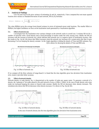
3.3. Effect of Anchor node density
I investigate the effect of percentage of anchor nodes in the network on the localization error variance. Ideally SD(σ) decreases
significantly as the density of anchors increases before a saturation point, and it remains the same after the saturation point.
Starting with 35 array nodes and two source nodes placed at random on fixed area of 100m ҳ 100 m, I moved to 10 source nodes
while keeping the array node constant. The result of simulation shows that in the case of Angle algorithm SD(σ) decreases
significantly as the density of anchors increases till a certain point and there after it starts increasing but in the case of RSS and
Time it follows the ideal behavior. It is shown in Fig. 3(a) & Fig. 3(b).
Fig. 3a Effect of Anchor node density Fig. 3b Effect of Anchor node density
The comparison of all three algorithms shows that here also the time algorithm is providing good results.
4. Conclusion
Localization is a fundamental problem of deploying wireless sensor networks for many applications. Although many
algorithms have been developed to solve the localization problem, the fundamental characterization of localization error
behaviors still needs to be studied. In this paper, I have analyzed the Standard Deviation of localization errors and have studied
the effects of network parameters on localization accuracy, which provides us insights on how to set the controllable parameters
of a sensor network for the best possible localization accuracy.I would like to conclude that for most of the network parameters
(network size, node density and source node density) the range based Time Algorithm provides the lowest deviation from the
mean localization error. This means lower the SD(σ) better the accuracy. So in comparison to RSS and angle one should use
Time Algorithm for localization purpose.
References
[1]. Archana Bharathidasan, Vijay Anand Sai Ponduru “Sensor Networks: An Overview” Department of Computer Science, University of
California, Davis, CA 95616.
[2]. D. Niculescu and B. Nath. Ad hoc positioning system. Global Communications Conference, IEEE, pages 2926–2931, November
2001.
[3]. M. Brain and T. Harris, “How GPS receivers work,” http://www.howstuffworks.com/gps1.htm.
[4]. J. Hightower and G. Borriello, Location systems for ubiquitous computing, Computer 34 (2001).
[5]. Georgios Sarigiannidis,, LOCALIZATION FOR AD HOC WIRELESS SENSOR NETWORKS, TECHNICAL UNIVERSITY
DELFT, THE NETHERLANDS, AUGUST 2006.
[6]. D. Estrin, R. Govindan, J. Heidemann, and S. Kumar, Next century challenges: scalable coordination in sensor networks, MobiCom
’99: Proceedings of the 5th annual ACM/IEEE international conference on Mobile computing and networking, ACM Press, 1999.
[7]. Byeong-Tae Lee, Sunwoo Kim, Scalable DV-Hop Localization For Wireless Sensor Networks, Department of Electronics Computer
and Communication Engineering, Hanyang University.
[8]. N. Bulusu, J. Heidemann, and D. Estrin. GPS-less low-cost outdoor localization for very small devices. Personal Communications,
IEEE, pages, Oct. 2000.
[9]. AZZEDINE BOUKERCHE “DV-LOC: A SCALABLE LOCALIZATION PROTOCOL USING VORONOI DIAGRAMS FOR
WIRELESS SENSOR NETWORKS, University Of Ottawa Horacio A.B.F. Oliveira, University Of Ottawa, Federal University Of
Minas Gerais And Federal University Of Amazonas.
[10]. K. Langendoen and N. Reijers. “Distributed localization in wireless sensor networks: A quantitative comparison”. Computer Networks,
2003.
[11]. David Christopher Moore “Robust Distributed Sensor Network Localization with Noisy Range Measurements” B.S., California
Institute of Technology (2003)
Issn 2250-3005(online) October| 2012 Page 87