SlideShare a Scribd company logo
MINERAL PROSPECTING AND EXPLORATION
Mining begins with prospecting and exploration stages with long periods of
investments and high risks of failure. Extracting of minerals with a profit.
Prospecting & Exploration discovers evidence of mineral occurrence and outline
its size and character. It’s Program should be designed to find and acquire a
maximum number of acceptable mineral deposits at a minimum cost and within a
minimum period of time.
Defining a mineral deposits is a collective efforts of geologists, geophysicist,
geochemists, metallurgists, mining engineers, chemists, lawyers and even
politicians.
• Prospect – surface indication of mineralization that requires investigation.
• Prospecting - is just part of exploration – it is the direct search for surface
indication of ore mineralization.
• Mineral – are naturally occurring substance that have a corresponding
chemical composition and distinct physical properties.
• Ore – any rock that contains enough mineral that can be mined at a profit.
• Mineral Deposit – any known mineral occurrence with a potential to become
an orebody worthwhile of mining.
To find and acquire new deposits:
- the explorer must have access to land;
- it must undergoes rigorous government approval and monitoring process;
- it must be capable of discovering deeply concealed (hidden) deposits which
have eluded previous explorers;
- the deposits must be amenable to economic extractive operations now or in
the future.
Each exploration entity shall defines its own objectives in terms of acceptable
minimum rate of return on investments (ROI) for any deposit found and retained, and
in terms of which commodities, and markets are to be involved.
Who are Qualified Mineral Prospector/ Explorer
- Geologist/Mining Engineer
- Any engineer or professional with background in mineral exploration
- Physically-fit and Good health
- Risk-taker and Adventurous
- Broad-minded and Patience
- Knowledgeable on Use of Exploration
- equipment/Apparatus
Factors to Consider in Prospecting
- Valid Existing Geologic Information
- Location and Accessibility
- Climatic Condition
- Terrain and Vegetations
- Local Permits & Clearances;
- Maps (topographic & geologic map);
- Peace and Order;
- Existing infrastructures and utilities at the prospect areas;
- Budget
Basic Geologic Instruments/Equipments in Prospecting
1. Brunton Compass, geologist pick, hand lens, pocket tape, cloth/chain tapes;
2. Geological knife, protractor, dilute HCl, magnet, nail, survey pads, cement
nails, sample tags, sample bags, marking pen, aluminum sheet folder;
3. Sample ring for holding sample bags during chip sampling, pencils, pens,
mapping sheets, log forms, field vest with large pockets, clipboard.
4. Portable Global Positioning System (GPS), camera, Laptop, etc.
• COMMON EXPLORATION TERMS:
• Rock – are aggregate of mineral
• Waste Rock – are barren rock in the mine.
• Host/Country Rock – are considered mother rock where the mineral is
enclosed/deposited/confined.
• Gossans – are ferruginous deposit filling the upper part of some mineral veins
forming superficial cover over masses of pyrite. It consist mainly of hydrated
iron oxides and has resulted from removal of sulfur as well as copper and
other sulfides originally present.
• Floats – are mineral exposures consisting of loose or traces of mineral
remnants found downslope of a mineral deposit.
• Bedrock – any solid rock in place underlying a soil, clay or other overburden.
• Gangue Mineral – valueless minerals associated in the ore.
• Talus – are transported broken rocks by surface water flowing downslope.
• Geologic Map- is a record of geological facts in their correct space relations
facts, be it noted, not theories..
PROSPECTING & EXPLORATION METHODS & TECHNIQUES
A. STAGES OF EXPLORATION
Stage 1 :Initial Prospecting Stage
- Field and Library Researches
- Reconnaissance Geologic Survey
- Rock Sampling & Laboratory Testing
- Plotting of Geologic Data & Map Interpretation
Stage 2 : Detailed Prospecting Stage
- Further Library/Field Researches
- Preliminary Geological Mapping
* Field Traverse along Rivers/Creeks & Roadcuts
* Aerial Photogeologic Study
* Stream Sediment Sampling (rocks & minerals)
- Laboratory Testing (petrographic/mineralographic)
- Plotting of Geologic Data on Maps/Interpretation
- Preparation of Prelim Report
Stage 3 : Exploration Stage
- Detailed Geologic Mapping of Indicative Areas
- Geochemical Testing
- Geophysical Investigation
- Drilling Investigation
- Laboratory Testing
- Preparation of Geologic Report
Stage 4: Ore Reserve Determination
- Geologic Modelling & Interpretation
- Ore Reserve Estimation
- Mine Evaluation
- Mine Pre-Feasibility Report
Prospecting Activities
1. Library and Field Researches – Gathering of old/existing geologic
reports, maps, etc.
2. Surface Geologic Mapping- Surface investigation as to color and textures
at the surface of weathered ore mineralization or outcrops are primary
consideration. The tracing of mineralized “float”, fragments of ore,
gossans and ore-associated rock that have been eroded and transported.
3. Trenching and/or Test Pitting – This involves excavation trial pits and
trenches to expose the surface outcrop. This is also to determine the
possible thickness of overburden and character of the ore deposit. If a vein
is exposed near the surface, remnants of the vein called “float” will
frequently appear downhill in the overburden material. If the vein material
is resistant to weathering, float usually starts appearing some distance
downhill from the hidden vein outcrop).
4. Field Sampling – Rock and Ore samples are collected from or near
outcrops for visual examination and laboratory
5. Laboratory Testing – Samples are subjected for petrographic &
mineralographic analysis.
6. Preparation of Geologic Reports
7. Presentation to Client/Investor
• What to map:
Any exposure of rock presents a wealth of detail:
- Soil and rock types
- Geological structures
- Physical properties
- Chemical properties
-Other surficial features (weathering, alteration)
* What to map first: It seems advisable to record all possible features foot by foot or
meter by meter as the mapping progresses.
• Where are Ore Minerals Found?
Minerals can not be planted like flowers. They can be found in as gained after
long and patient search. They are usually found in:
- Local stone quarries or abandoned quarries
- Heaps of Mine Refuse
- Abandoned shafts and caves;
- Road construction, dams and tunnels
- Digging graves
- Rocky banks of rivers & brooks
- River beds or gravel pits
Prospecting Techniques
1. Heavy Mineral Panning
2. Airborne & Satellite Techniques
3. Fluid Inclusion Studies
4. Isotope Studies
5. Portable X-ray Fluorescent Analyzer
6. Laser Techniques
• Heavy Mineral Panning - applicable to resistant metal and minerals with
high specific gravity like: gold, platinum, cassiterite, tungsten, barite.
• Airborne and Satellite Techniques - done by aerial photography
supplemented by a satellite-airborne electronic imaging system to map
structural, lithologic and alteration features.
An example of satellite-airborne imaging system is a Multispectral Scanner
(MSS)
• Fluid Inclusion Isotopes
- Detect fluids during ore-forming processes. The fluids
(hydrothermal solutions) are those that are:
- entrapped during the growth of its host crystals
- entrapped after the growth of host crystal occurring along
microfractures
Isotope – any of two or more species of atoms of a chemical element with
same atomic number and nearly identical chemical behavior but
w/ differing atomic mass and different physical properties.
• Isotope Studies
- the study of the different properties of isotopes in a mineral.
• Portable X-ray Flourescent Analyzer
- detect radioisotope sources to irradiate the sampled material with gamma
rays;
- very limited penetration of less than 3mm
- metals detected by portable analyzer are Cu, Sn, Mo, Pb, Zn, Ni, Fe, Ti, Tn,
Ba, Zr, Ag.
• Laser Techniques
- utilize laser beam (luminex system) to measure luminescent radiation coming
from minerals. The luminex system can detect and quantify responsive
minerals occurring in an outcrop;
- used to detect metals like tungsten, zinc, molybdenum, and gold.
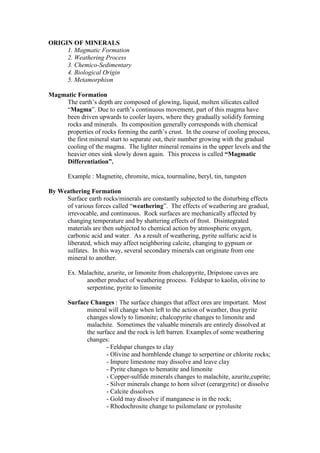
ORIGIN OF MINERALS
1. Magmatic Formation
2. Weathering Process
3. Chemico-Sedimentary
4. Biological Origin
5. Metamorphism
Magmatic Formation
The earth’s depth are composed of glowing, liquid, molten silicates called
“Magma”. Due to earth’s continuous movement, part of this magma have
been driven upwards to cooler layers, where they gradually solidify forming
rocks and minerals. Its composition generally corresponds with chemical
properties of rocks forming the earth’s crust. In the course of cooling process,
the first mineral start to separate out, their number growing with the gradual
cooling of the magma. The lighter mineral remains in the upper levels and the
heavier ones sink slowly down again. This process is called “Magmatic
Differentiation”.
Example : Magnetite, chromite, mica, tourmaline, beryl, tin, tungsten
By Weathering Formation
Surface earth rocks/minerals are constantly subjected to the disturbing effects
of various forces called “weathering”. The effects of weathering are gradual,
irrevocable, and continuous. Rock surfaces are mechanically affected by
changing temperature and by shattering effects of frost. Disintegrated
materials are then subjected to chemical action by atmospheric oxygen,
carbonic acid and water. As a result of weathering, pyrite sulfuric acid is
liberated, which may affect neighboring calcite, changing to gypsum or
sulfates. In this way, several secondary minerals can originate from one
mineral to another.
Ex. Malachite, azurite, or limonite from chalcopyrite, Dripstone caves are
another product of weathering process. Feldspar to kaolin, olivine to
serpentine, pyrite to limonite
Surface Changes : The surface changes that affect ores are important. Most
mineral will change when left to the action of weather, thus pyrite
changes slowly to limonite; chalcopyrite changes to limonite and
malachite. Sometimes the valuable minerals are entirely dissolved at
the surface and the rock is left barren. Examples of some weathering
changes:
- Feldspar changes to clay
- Olivine and hornblende change to serpertine or chlorite rocks;
- Impure limestone may dissolve and leave clay
- Pyrite changes to hematite and limonite
- Copper-sulfide minerals changes to malachite, azurite,cuprite;
- Silver minerals change to horn silver (cerargyrite) or dissolve
- Calcite dissolves
- Gold may dissolve if manganese is in the rock;
- Rhodochrosite change to psilomelane or pyrolusite
Chemico-Sedimentary Formation
Various minerals are deposited from the sea water as a result of evaporation,
or of a change in its chemical composition.
Ex. Rock salt, sylvine, gypsum, calcite and some iron ores such as
chamosite originate in this process.
Biological Origin
New minerals can be formed from mineral substances dissolved in water.
Coral island and limestone bodies are the product of living organisms. New
mineral can also originate from decomposed remnants of dead organisms,
such as phosphate, sulfur, pyrite and marcasite. Coal was formed from
accumulation of plant material buried beneath the surface that has undergone
incomplete oxidation.
Metamorphism
Molten magma affect the crust layer by its temperature, pressure, chemical
reaction with various substances. This caused the sedimentary rocks to change
to their appearance, physical, and chemical properties. This process during
which new secondary metamorphic rocks and minerals originate is called
“Contact Metamorphism”.
Ex. Mica, Garnet, Kyanite
How Different Ores are Formed
1. Depth in the earth are masses of molten rock, and because the pressure is
great and these masses are so hot, they gradually “eat” their way
toward the surface of the earth. Some of them reach the surface, such
as the formation of volcanoes, but some of them cool and harden
before they reach the surface. Because of the pressure and heat of the
solid rocks around these molten masses, it forms cracks and these
cracks are filled with some molten rock which resulted to the
formation of dikes and sills. When these molten rock hardens lead to
IGNEOUS ROCKS.
2. The molten rock masses usually contain large quantities of water and steam.
These may soak out into the solid rock next to the cooling of melted
rock and will then change the nature of solid rock. Sometimes the
water and steam are barren of valuable ores while at other times the hot
water, soaking in, brings ore of gold, silver, copper, tungsten, or other
metals.
3. Fissure Vein are formed when a mass of molten rock started cooling, and
large quantities of liquids and gases are given off. Some of them soak
into the rock but more will follow cracks and crevices and deposit the
mineral matter on these cracks, but sometimes there are thousands of
small cracks, thud forming an uneven and irregular vein. The waters
forming these veins are hot and are under pressure, so that when they
soak into the walls of the cracks, the ore may be wider than the actual
vein crack. Vein formed often have quartz, calcite, fluorite or pyrite in
the gangue.
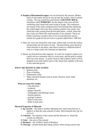
4. Porphyry/Disseminated copper ores are formed by this process. Molten
mass of rock matter forced its way up near the surface, when it started
cooling. The top cooled first and formed a GRANITIC ROCK,
sometimes called PORHYRY, but the deeper rocks were still hot
containing some steam and water trying to escape. The continuous
movement of the earth created pressure from beneath thus shattering
the cooled upper rock layer thus creating countless tiny cracks, into
which the water coming from the hot parts below cooled, where the
tiny cracks are filled with small amounts of ore minerals. These ore
bodies sometimes extend a mile or two in each direction and are
usually low grade but do not exist to a greater depth below 1000 feet.
5. There are veins also formed by cold water, which soaks in from the surface
and percolate into the layers of rock. The percolating water dissolves
some minerals in one place, and when it comes to a different kind of
rock or to large cracks, the minerals are deposited;
6. Placers are formed from other deposits. As water for centuries washes over
a gold vein on a mountain side it is worn away, and the gold is carried
down by some stream. As gold is heavier than ordinary sand it will be
dropped in any little hollow parts in the stream bed, together with more
or less sand and gravel;
WHAT ARE REGIONAL ORE GUIDES
• Igneous rocks
• Zone of faulting
• Sedimentary rocks
• Major structural features such as joints, fractures, karst, folds,
alteration, etc.
What are some Ore Guides
- rock alteration
- oxidation
- gangue minerals
- stratigraphic and lithologic layers
- fracture patterns
- geologic contacts
- folds in rock mass
- faults in rock mass
Physical Properties of Minerals
1. Sp. Gravity – the relative number indicating how many times heavier or
lighter it is than the same amount of water. Most minerals have Sp. Gr.
of 2 to 4.
2. Cohesion – the structure of the crystal and the direction in which the
crystals are affected.
3. Color - the color of the mineral
4. Hardness – the 10 Moh’s Scale of Hardness
5. Cleavage - crystals break apart along surfaces when writing can be read
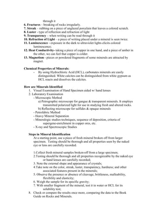
through it
6. Fractures – breaking of rocks irregularly.
7. Streak – rubbing on a piece of unglazed porcelain that leaves a colored scratch.
8. Luster - type of reflection and refraction of light
9. Transparency – when writing can be read through it
10. Refraction of Light – a piece of writing placed under a mineral is seen twice.
11. Luminescence - exposure in the dark to ultraviolet lights elicits colored
luminescence;
12. Heat Conductivity- taking a piece of copper in one hand, and a piece of amber in
the other, we can feel that copper is colder.
13. Magnetism - pieces or powdered fragments of some minerals are attracted by
magnet.
Chemical Properties of Minerals:
- By using Hydrochloric Acid (HCL), carbonates minerals are easily
distinguished. White calcites can be distinguished from white gypsum as
HCL reacts and dissolves the calcites.
How are Minerals Identified
1. Visual Examination of Hand Specimen aided w/ hand lenses
2. Laboratory Examination
- Microscopic Method
a) Petrographic microscope for gangue & transparent minerals. It employs
transmitted polarized light for use in studying fresh and altered rocks.
b) Reflecting microscope for sulfides & opaque minerals
- Petrofabric Method
- Heavy Mineral Separation
- Mineralogic studies-techniques, sequence of deposition, criteria of
supergene-enrichment in copper ores, etc.
- X-ray and Spectroscopic Studies
Steps in Mineral Identification
At a starting point, use a piece of fresh mineral broken off from larger
specimen. Testing should be thorough and all properties seen by the naked
eye or lens are carefully recorded.
1.Collect fresh mineral samples broken-off from a large specimen;
2.Testing should be thorough and all properties recognizable by the naked eye
or hand lenses are carefully recorded;
3. Note the external shape and appearance of crystals;
4.Take note on the color, streak, luster, transparency, hardness; and other
associated features present in the minerals;
5. Observe the presence or absence of cleavage, brittleness, malleability,
flexibility and elasticity;
6. Weigh the sample for its specific gravity;
7. With smaller fragment of the mineral, test it in water or HCL for its
solubility test;
8. Check or compare the results once more, comparing the data to the Book
Guide on Rocks and Minerals.
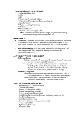
Sequence in Logging a Mineral Sample:
1. Mineral and Host Rock
2. Color
3. pH
4. Weathering/Alteration/Oxidation
5. Grain/Crystal Arrangement (Texture, sorting, etc)
6. Specific Gravity
7. Degree of Jointing/Fracturing
8. Hardness
9. Streak and Luster
10. Percent Core Recovery (% CR)
11. Other descriptive features in mineral sample (magnetic, transparency,
associated secondary mineral components, etc.)
EXPLORATION
• Exploration - is to look and search for something valuable to man. It includes
all activities involved the discovery and evaluation of ore deposit, its size,
grade, initial flowsheet and annual output of the new extractive operation.
• Mineral Exploration – is defined as the scientific investigation of the earth
crust to determine if there are mineral deposit present that maybe
commercially developed.
MAIN OBJECTIVES OF EXPLORATION
To Human Beings:
- To discover more God’s given natural resources for man’s maximum
use in a wise and sustainable manner;
-To provide the basic necessities of man to survive where almost
everything that we eat, drink, wear, drive, live-in, fly-in
depends on the products of mineral industries for either its
components, its production, and its source of energy;
To Mining Companies:
- To find an economic mineral deposit that will increase the value of
the company’s stocks to the stockholders on a continuing basis;
- To find and acquire a maximum number of mineral deposits at a
minimum cost and within a minimum period of time.
Factors to Consider in Exploration Work
- Scope of work of exploration project;
- Permits & Clearances;
- Amount of existing information;
- General geology of the prospect;
- Type of sampling and data required;
- Availability of exploration technology, equipment, manpower, etc.
- Capability of equipment
- Cost of exploration works;
- Environment (terrain, access, vegetation, etc.)
- Social Acceptability;
- Right-of-way to the site;
- Peace and Order
- Availability of infrastructures and utilities.
Mineral Exploration Methods
1. Geological Exploration
2. Geochemical Exploration
3. Geophysical Exploration
4. Drilling Exploration
5. Mining Exploration
I. GEOLOGICAL EXPLORATION :
A prime tool in mineral exploration & includes
the following:
- derivation of target concepts;
- collection of available geologic data (mapping,
alteration & zoning studies, core logging, etc.);
- interpretation of data collected;
- integration of geologic data on maps
Activities Involved:
- Office/Library Researches/Compilation
- Photo-geologic Study (Aerial/Ground)
- Outcrop Examination
- Geologic Mapping/Investigation
- Geologic Logging
- Boulder Tracking
- Test Pitting & Trenching
Types of Mapping
• Surface Mapping- a field activity conducted by geologist or engineers to
trace, locate and record surficial geological information and plotted in
map.
• Underground Mapping - a subsurface activity conducted by geologist or
engineer in the mines to trace, locate and update geological records and
plotted in map.
• Air Photograph Mapping - a field activity through the use of an aircraft
to trace, locate and other surficial geological features using high polarizing
cameras.
2. GEOCHEMICAL EXPLORATION
- Defines the analytical measurements & chemical interpretation of the
abundance of an element in naturally-occurring materials such as soil,
rocks, water, air/gases, gossans, plants, micro-organisms, animal tissues,
particulate and stream sediments.
- Includes molecular & isotropic concentration and composition or bacterial
counts;
Geochemical Exploration Methods
a) Stream Sediment Sampling
b) Water Sampling
c) Rock Sampling
d) Specialized Sampling
e) Assaying
Activities Involved:
A. Field Survey – This involves the collection of closely spaced
samples within the vicinity but preferably undisturbed
mineralization;
B. Sample Collection and Handling - This requires well-trained
personnel capable of recognizing and describing the
correct sample material and the sample site
characteristics. The samplers should be able to
recognize and if possible avoid situation where
contamination from human activity or changes in the
natural physiochemical conditions can produce spurious
or unusual results. This must be under the supervision
of a geochemist or geologist.
Sampling Media :
1. Soil – are mixture of mineral & biologic matter. They are classified as
residual and transported materials and vary in composition & appearance
according to their genetic, climatic, & geographic environment.
- Residual soils may contain detectable dispersion patterns developed
during the weathering of mineralization of underlying
bedrock.
- Transported soil present more difficult sampling problems, but
meaningful sampling is possible once the genetic origins of
transported cover are understood;
Soils are sampled along traverses or grids in the follow-up or detailed
prospecting stage of a geochemical program.
2. Stream Sediments and Water : Stream sediment are natural composite
sample of erosion materials from upstream derived from weathered
mineralization.
3. Lake Sediments & Water : The sampling focuses in the collection of
organic mud using especially-designed sampling device.
4. Rock Samples: The systematic sampling of outcrops, trenches, drill cores
or cuttings within the zone of oxidation and weathering. Rock samples
are grind and pulverized to grain size of less than 150-200 mesh.
5. Microorganisms : This organism is “Bacillus Cereus” which increases with
the natural increase of precious metal content of soils in the vicinity of
the known mineral deposits.
6. Gases and Air : Some mineral deposit produces gaseous emanations that
can be detected by specialized measurements. Radon for example is
produced during the radioactive decay of uranium and radium. Helium
produced during radiogenic decay with deep-seated origin. Mercury
produce by sphalerite and other sulfides.
How To Prepare Samples for Geochemical Test:
1.Drying : Exposure to sun or dried in an oven heating in excess of
1600F (700C) can lead to less volatile elements that may of
value to exploration.
2. Sieving and Crushing: Using pestle and mortar or others (80-mesh)
3. Heavy Mineral Separation
4. Treatment of Chemical Reagents
5. Laboratory Analysis
3. GEOPHYSICAL EXPLORATION
Geophysical-Airborne
- Aeromagnetic Survey
- Electromagnetic Survey
- Radiometric Survey
- Remote Sensing
Geophysical – Ground
- Gravity - Seismic
- Magnetic - Electrical
- Radiometric
* Aeromagnetic Survey
- conducted from an aircraft to detect the earth’s magnetic fields to at least
an accuracy of a gamma.
- a map shows the magnetic intensity over the area being surveyed as basis
for interpreting the probable distribution of magnetic rocks in the
earth’s crust.
- susceptability of a mineral to magnetization depends on volume of
magnetite content, field strength, grain size, presence of less common
magnetic minerals, and the state of natural remanent magnetization.
Ex.Magnetite-ilmenite series, magnetite associated w/ gold placers, phrrhotite,
magnetite-chalcopyrite, magnetic nickel ores.
• Electromagnetic Survey
- conducted on fixed-wing aircraft used employing either continuous
wave frequency domain, wave forms or pulse-time domain
techniques;
- applicable to electrically conductive minerals such as massive sulfide
orebodies;
• Radiometric Survey
- set-up in an aircraft where gamma rays will penetrate into several
hundred feet through the atmosphere but few inches into the
earth to attenuate natural radiation;
- gamma ray detectors consist of crystal that is activated to give off a
minute flash of light upon being stuck by an ionizing gamma
particles.
Ex. Uranium, thorium, etc.
• Remote Sensing
- uses a high-altitude-radar-equip aircraft that maps earth’s topography
by using satellite images to detect buried pipes, bedrock and
mineralized boulders.
- an energy is emitted in the radio portion of the electromagnetic
spectrum of which the source portion is reflected back to the
radar equipment. The single pulse radar wave is applied
directly to ground surface or U/G tunnel and boreholes. The
wave is turned and registered a video pulse which appear
similar to seismic refraction wave. Irregularities on the wave
action indicate reflector such as clay-filled, fault zone in
crystalline rocks, cavern or rock.
Limitation: In development stage, does not provide depths or
engineering properties, shallow penetration of about 10-15 meters
only.
Ground Geophysical Methods
• Gravity Method
- Uses new cryogenic & mechanical-optical gravimeters to measure
gravity variations and proved successful to detect small masses
& subsurface voids (caves or tunnels);
- buried channels that may contain gold or uranium minerals can be
located by gravity or seismic method because the channel fill is
less dense that the rock in which the channel has been cut.
Bouguer Anomaly - that part of the difference between measured gravity and
theoretical gravity which is a result of purely of lateral variations in
material density
Other factors affecting gravity are altitude and topography. Old gravimeters
consisting of spring pendulum same as seismograph (Eotvos Torsion
Balance) where heavy masses attract the instruments & conversely,
light masses allow the instruments to be deflected away from them.
Applicability: Widely used in petroleum geology but until recently have
found little use in ore search partly because of rough topographic
characteristic. It is normally used for cavity detection in limestone for
engineering studies. - ores detected are chromite, hematite, barite that
have such high density compared with the material that surrounds them
Limitations: Detect major subsurface structures such as faults, domes,
intrusion or cavities;
• Magnetic Survey
- Many rocks contain small but significant quantities of ferro-magnetic
minerals which vary with rock type. The weak magnetization
modifies the earth’s magnetic field to an extent that can be
detected by sensitive instrument called “Magnetometers”.
Application:
-Mineral prospecting & location of large igneous masses;
- Magnetic orebodies that are strongly magnetic;
Limitation: Normally not used in engineering studies;
Equipment: Magnetometers – provide the measurements and when
place in aircraft.
2. Electrical Method
-Various surface material have characteristic conductance for direct
currents of electricity. Electrolytic action, usually made
possible by the presence of moisture and dissolved salts w/in
the soil/rock formation, permit the passage of current between
electrodes placed in soil surface. In general, conductance is
good in such material as moist clay and silts, and poor material
such as dry loose sands, gravel and sound rock.
Resistivity – refers to the resistance to current flow developed in geologic
materials, and is expressed as OHM-CM2/CM or simply as OHM-CM
or OHM-FT.
Applicability:
- Locate water boundaries, clean granular & clay strata, rock bedrock;
- Massive sulfide bodies such as arsenopyrite, chalcopyrite;
- Outlining the contour of bedrock surface in placer deposit;
- Locating quartz veins, cavities in limestone, potential failure;
- Thickness of organic deposit & depth of GWL.
Limitation: Difficult to interpret and subject to wide variations. Does not
provide engineering properties.
Basic Equipment: Terrameter, battery (energy source), potential meter,
electrodes
• Seismic Method
- consist of detonating a charge of dynamite or other explosives and
measuring the reflection and refraction of artificial earthquake waves set-
up by a shock. Elastic waves travel through geologic media at
characteristic velocities. The waves passing the material finally arrives at
the surface where they detected and recorded by an instruments.
Types of Seismic Methods:
a) Refraction Method
b) Reflection Method
a. Refraction Method
- determine stratum depth & character velocities in land/water;
- ideal for land exploration to depths of less than 300 meter because of
direct and refracted waves arrive first and tend to mask the reflected
waves;
- locate faults or underground caverns.
Limitations: Maybe unreliable unless velocities increase with and bedrock
surface is regular. Data are indirect and represent average.
Basic Equipment: Energy source (hammer or explosive); elastic wave
detonators (seismometers) which are geophones (electro-mechanical
transducer); seismograph (power source); amplifiers; timing device;
and recorder.
b. Reflection Method:
Application: Not used on land for engg studies but useful for offshore
continuous profiling. Provide a pictorial record of sea-bottom profile
showing changes of strata, salt domes, faults and marine slides.
Limitation: Does not provide velocities computation of depths to stratum.
Changes require velocity data obtained from other means.
Basic Equipment:
1) Boomers-operate in water depth (3-200m) and provide high
resolution (15-30cm) but moderate penetration(100m);
2) Sparkers-operate in water depth (10-600m), high resolution of about
15-25m w/ penetration depth of 1,200m or more
3) Vessel-carry personnel and equipment

More Related Content

Similar to Notes Mine Exploration.doc

pengenalan industri minyak dan gas bumi.
pengenalan industri minyak dan gas bumi.pengenalan industri minyak dan gas bumi.
pengenalan industri minyak dan gas bumi.
sultan260606
 
S1112ES-Ic-d-8.pptx
S1112ES-Ic-d-8.pptxS1112ES-Ic-d-8.pptx
S1112ES-Ic-d-8.pptx
RaceDeVilla
 
lect 4- petroleum exploration- part1.pdf
lect 4- petroleum exploration- part1.pdflect 4- petroleum exploration- part1.pdf
lect 4- petroleum exploration- part1.pdf
tahahaider8
 
Direct-prospecting methods_Presentation.ppt
Direct-prospecting methods_Presentation.pptDirect-prospecting methods_Presentation.ppt
Direct-prospecting methods_Presentation.ppt
Dr. Arzu Javadova
 
remote sensing mineral exploration.pptx
remote sensing mineral exploration.pptxremote sensing mineral exploration.pptx
remote sensing mineral exploration.pptx
omkarkadekar2
 
Petroleum Geology/Engineering
Petroleum Geology/EngineeringPetroleum Geology/Engineering
Petroleum Geology/Engineering
Arshad Ayub
 
Gravity and magmetic method
Gravity and magmetic methodGravity and magmetic method
Gravity and magmetic method
Shah Naseer
 
4 mining and its impacts to environment
4 mining and its impacts to environment4 mining and its impacts to environment
4 mining and its impacts to environment
anonymous143
 
Rocks minerals and their exploitation (1)
Rocks minerals and their exploitation (1)Rocks minerals and their exploitation (1)
Rocks minerals and their exploitation (1)
Lunz70
 
Applications Gravity survey Magnetic survey Electrical resistivity survey Sei...
Applications Gravity survey Magnetic survey Electrical resistivity survey Sei...Applications Gravity survey Magnetic survey Electrical resistivity survey Sei...
Applications Gravity survey Magnetic survey Electrical resistivity survey Sei...
University of Azad Jammu & Kashmir
 
Similarities between gravity and magnetics and application of different geoph...
Similarities between gravity and magnetics and application of different geoph...Similarities between gravity and magnetics and application of different geoph...
Similarities between gravity and magnetics and application of different geoph...
Jyoti Khatiwada
 
Earth Science_W6-Ores_Mining Process (students' copy).pdf
Earth Science_W6-Ores_Mining Process (students' copy).pdfEarth Science_W6-Ores_Mining Process (students' copy).pdf
Earth Science_W6-Ores_Mining Process (students' copy).pdf
MydelCampehios
 
Marine Geophysics
Marine GeophysicsMarine Geophysics
Marine Geophysics
Hafez Ahmad
 
Astronomy mars section 2 student copy
Astronomy mars section 2 student copyAstronomy mars section 2 student copy
Astronomy mars section 2 student copyloganwilkinson
 
Geophysical studies
Geophysical studiesGeophysical studies
Geophysical studies
Dr. M Prasad
 
Earth Science: Mining Ore Minerals and Mineral Processing
Earth Science: Mining Ore Minerals and Mineral ProcessingEarth Science: Mining Ore Minerals and Mineral Processing
Earth Science: Mining Ore Minerals and Mineral Processing
MarkNicholzSimporios
 
An overview of mining methods
An  overview  of  mining methodsAn  overview  of  mining methods
An overview of mining methods
Prof. A.Balasubramanian
 
Geological criteria for ore prospecting.pptx
Geological criteria for ore prospecting.pptxGeological criteria for ore prospecting.pptx
Geological criteria for ore prospecting.pptx
Masroor4
 
Prospecting and exploration
Prospecting and explorationProspecting and exploration
Prospecting and exploration
Sadath Solaiman
 
Gemology/Gemmology in forensic science .pptx
Gemology/Gemmology in forensic science .pptxGemology/Gemmology in forensic science .pptx
Gemology/Gemmology in forensic science .pptx
Bhanu Yadav
 

Similar to Notes Mine Exploration.doc (20)

pengenalan industri minyak dan gas bumi.
pengenalan industri minyak dan gas bumi.pengenalan industri minyak dan gas bumi.
pengenalan industri minyak dan gas bumi.
 
S1112ES-Ic-d-8.pptx
S1112ES-Ic-d-8.pptxS1112ES-Ic-d-8.pptx
S1112ES-Ic-d-8.pptx
 
lect 4- petroleum exploration- part1.pdf
lect 4- petroleum exploration- part1.pdflect 4- petroleum exploration- part1.pdf
lect 4- petroleum exploration- part1.pdf
 
Direct-prospecting methods_Presentation.ppt
Direct-prospecting methods_Presentation.pptDirect-prospecting methods_Presentation.ppt
Direct-prospecting methods_Presentation.ppt
 
remote sensing mineral exploration.pptx
remote sensing mineral exploration.pptxremote sensing mineral exploration.pptx
remote sensing mineral exploration.pptx
 
Petroleum Geology/Engineering
Petroleum Geology/EngineeringPetroleum Geology/Engineering
Petroleum Geology/Engineering
 
Gravity and magmetic method
Gravity and magmetic methodGravity and magmetic method
Gravity and magmetic method
 
4 mining and its impacts to environment
4 mining and its impacts to environment4 mining and its impacts to environment
4 mining and its impacts to environment
 
Rocks minerals and their exploitation (1)
Rocks minerals and their exploitation (1)Rocks minerals and their exploitation (1)
Rocks minerals and their exploitation (1)
 
Applications Gravity survey Magnetic survey Electrical resistivity survey Sei...
Applications Gravity survey Magnetic survey Electrical resistivity survey Sei...Applications Gravity survey Magnetic survey Electrical resistivity survey Sei...
Applications Gravity survey Magnetic survey Electrical resistivity survey Sei...
 
Similarities between gravity and magnetics and application of different geoph...
Similarities between gravity and magnetics and application of different geoph...Similarities between gravity and magnetics and application of different geoph...
Similarities between gravity and magnetics and application of different geoph...
 
Earth Science_W6-Ores_Mining Process (students' copy).pdf
Earth Science_W6-Ores_Mining Process (students' copy).pdfEarth Science_W6-Ores_Mining Process (students' copy).pdf
Earth Science_W6-Ores_Mining Process (students' copy).pdf
 
Marine Geophysics
Marine GeophysicsMarine Geophysics
Marine Geophysics
 
Astronomy mars section 2 student copy
Astronomy mars section 2 student copyAstronomy mars section 2 student copy
Astronomy mars section 2 student copy
 
Geophysical studies
Geophysical studiesGeophysical studies
Geophysical studies
 
Earth Science: Mining Ore Minerals and Mineral Processing
Earth Science: Mining Ore Minerals and Mineral ProcessingEarth Science: Mining Ore Minerals and Mineral Processing
Earth Science: Mining Ore Minerals and Mineral Processing
 
An overview of mining methods
An  overview  of  mining methodsAn  overview  of  mining methods
An overview of mining methods
 
Geological criteria for ore prospecting.pptx
Geological criteria for ore prospecting.pptxGeological criteria for ore prospecting.pptx
Geological criteria for ore prospecting.pptx
 
Prospecting and exploration
Prospecting and explorationProspecting and exploration
Prospecting and exploration
 
Gemology/Gemmology in forensic science .pptx
Gemology/Gemmology in forensic science .pptxGemology/Gemmology in forensic science .pptx
Gemology/Gemmology in forensic science .pptx
 

Recently uploaded

一比一原版(UofT毕业证)多伦多大学毕业证成绩单如何办理
一比一原版(UofT毕业证)多伦多大学毕业证成绩单如何办理一比一原版(UofT毕业证)多伦多大学毕业证成绩单如何办理
一比一原版(UofT毕业证)多伦多大学毕业证成绩单如何办理
ydteq
 
Fundamentals of Electric Drives and its applications.pptx
Fundamentals of Electric Drives and its applications.pptxFundamentals of Electric Drives and its applications.pptx
Fundamentals of Electric Drives and its applications.pptx
manasideore6
 
MCQ Soil mechanics questions (Soil shear strength).pdf
MCQ Soil mechanics questions (Soil shear strength).pdfMCQ Soil mechanics questions (Soil shear strength).pdf
MCQ Soil mechanics questions (Soil shear strength).pdf
Osamah Alsalih
 
Hierarchical Digital Twin of a Naval Power System
Hierarchical Digital Twin of a Naval Power SystemHierarchical Digital Twin of a Naval Power System
Hierarchical Digital Twin of a Naval Power System
Kerry Sado
 
Basic Industrial Engineering terms for apparel
Basic Industrial Engineering terms for apparelBasic Industrial Engineering terms for apparel
Basic Industrial Engineering terms for apparel
top1002
 
Railway Signalling Principles Edition 3.pdf
Railway Signalling Principles Edition 3.pdfRailway Signalling Principles Edition 3.pdf
Railway Signalling Principles Edition 3.pdf
TeeVichai
 
Pile Foundation by Venkatesh Taduvai (Sub Geotechnical Engineering II)-conver...
Pile Foundation by Venkatesh Taduvai (Sub Geotechnical Engineering II)-conver...Pile Foundation by Venkatesh Taduvai (Sub Geotechnical Engineering II)-conver...
Pile Foundation by Venkatesh Taduvai (Sub Geotechnical Engineering II)-conver...
AJAYKUMARPUND1
 
AP LAB PPT.pdf ap lab ppt no title specific
AP LAB PPT.pdf ap lab ppt no title specificAP LAB PPT.pdf ap lab ppt no title specific
AP LAB PPT.pdf ap lab ppt no title specific
BrazilAccount1
 
Planning Of Procurement o different goods and services
Planning Of Procurement o different goods and servicesPlanning Of Procurement o different goods and services
Planning Of Procurement o different goods and services
JoytuBarua2
 
block diagram and signal flow graph representation
block diagram and signal flow graph representationblock diagram and signal flow graph representation
block diagram and signal flow graph representation
Divya Somashekar
 
Final project report on grocery store management system..pdf
Final project report on grocery store management system..pdfFinal project report on grocery store management system..pdf
Final project report on grocery store management system..pdf
Kamal Acharya
 
Top 10 Oil and Gas Projects in Saudi Arabia 2024.pdf
Top 10 Oil and Gas Projects in Saudi Arabia 2024.pdfTop 10 Oil and Gas Projects in Saudi Arabia 2024.pdf
Top 10 Oil and Gas Projects in Saudi Arabia 2024.pdf
Teleport Manpower Consultant
 
DfMAy 2024 - key insights and contributions
DfMAy 2024 - key insights and contributionsDfMAy 2024 - key insights and contributions
DfMAy 2024 - key insights and contributions
gestioneergodomus
 
Industrial Training at Shahjalal Fertilizer Company Limited (SFCL)
Industrial Training at Shahjalal Fertilizer Company Limited (SFCL)Industrial Training at Shahjalal Fertilizer Company Limited (SFCL)
Industrial Training at Shahjalal Fertilizer Company Limited (SFCL)
MdTanvirMahtab2
 
ML for identifying fraud using open blockchain data.pptx
ML for identifying fraud using open blockchain data.pptxML for identifying fraud using open blockchain data.pptx
ML for identifying fraud using open blockchain data.pptx
Vijay Dialani, PhD
 
Student information management system project report ii.pdf
Student information management system project report ii.pdfStudent information management system project report ii.pdf
Student information management system project report ii.pdf
Kamal Acharya
 
Immunizing Image Classifiers Against Localized Adversary Attacks
Immunizing Image Classifiers Against Localized Adversary AttacksImmunizing Image Classifiers Against Localized Adversary Attacks
Immunizing Image Classifiers Against Localized Adversary Attacks
gerogepatton
 
CME397 Surface Engineering- Professional Elective
CME397 Surface Engineering- Professional ElectiveCME397 Surface Engineering- Professional Elective
CME397 Surface Engineering- Professional Elective
karthi keyan
 
Forklift Classes Overview by Intella Parts
Forklift Classes Overview by Intella PartsForklift Classes Overview by Intella Parts
Forklift Classes Overview by Intella Parts
Intella Parts
 
HYDROPOWER - Hydroelectric power generation
HYDROPOWER - Hydroelectric power generationHYDROPOWER - Hydroelectric power generation
HYDROPOWER - Hydroelectric power generation
Robbie Edward Sayers
 

Recently uploaded (20)

一比一原版(UofT毕业证)多伦多大学毕业证成绩单如何办理
一比一原版(UofT毕业证)多伦多大学毕业证成绩单如何办理一比一原版(UofT毕业证)多伦多大学毕业证成绩单如何办理
一比一原版(UofT毕业证)多伦多大学毕业证成绩单如何办理
 
Fundamentals of Electric Drives and its applications.pptx
Fundamentals of Electric Drives and its applications.pptxFundamentals of Electric Drives and its applications.pptx
Fundamentals of Electric Drives and its applications.pptx
 
MCQ Soil mechanics questions (Soil shear strength).pdf
MCQ Soil mechanics questions (Soil shear strength).pdfMCQ Soil mechanics questions (Soil shear strength).pdf
MCQ Soil mechanics questions (Soil shear strength).pdf
 
Hierarchical Digital Twin of a Naval Power System
Hierarchical Digital Twin of a Naval Power SystemHierarchical Digital Twin of a Naval Power System
Hierarchical Digital Twin of a Naval Power System
 
Basic Industrial Engineering terms for apparel
Basic Industrial Engineering terms for apparelBasic Industrial Engineering terms for apparel
Basic Industrial Engineering terms for apparel
 
Railway Signalling Principles Edition 3.pdf
Railway Signalling Principles Edition 3.pdfRailway Signalling Principles Edition 3.pdf
Railway Signalling Principles Edition 3.pdf
 
Pile Foundation by Venkatesh Taduvai (Sub Geotechnical Engineering II)-conver...
Pile Foundation by Venkatesh Taduvai (Sub Geotechnical Engineering II)-conver...Pile Foundation by Venkatesh Taduvai (Sub Geotechnical Engineering II)-conver...
Pile Foundation by Venkatesh Taduvai (Sub Geotechnical Engineering II)-conver...
 
AP LAB PPT.pdf ap lab ppt no title specific
AP LAB PPT.pdf ap lab ppt no title specificAP LAB PPT.pdf ap lab ppt no title specific
AP LAB PPT.pdf ap lab ppt no title specific
 
Planning Of Procurement o different goods and services
Planning Of Procurement o different goods and servicesPlanning Of Procurement o different goods and services
Planning Of Procurement o different goods and services
 
block diagram and signal flow graph representation
block diagram and signal flow graph representationblock diagram and signal flow graph representation
block diagram and signal flow graph representation
 
Final project report on grocery store management system..pdf
Final project report on grocery store management system..pdfFinal project report on grocery store management system..pdf
Final project report on grocery store management system..pdf
 
Top 10 Oil and Gas Projects in Saudi Arabia 2024.pdf
Top 10 Oil and Gas Projects in Saudi Arabia 2024.pdfTop 10 Oil and Gas Projects in Saudi Arabia 2024.pdf
Top 10 Oil and Gas Projects in Saudi Arabia 2024.pdf
 
DfMAy 2024 - key insights and contributions
DfMAy 2024 - key insights and contributionsDfMAy 2024 - key insights and contributions
DfMAy 2024 - key insights and contributions
 
Industrial Training at Shahjalal Fertilizer Company Limited (SFCL)
Industrial Training at Shahjalal Fertilizer Company Limited (SFCL)Industrial Training at Shahjalal Fertilizer Company Limited (SFCL)
Industrial Training at Shahjalal Fertilizer Company Limited (SFCL)
 
ML for identifying fraud using open blockchain data.pptx
ML for identifying fraud using open blockchain data.pptxML for identifying fraud using open blockchain data.pptx
ML for identifying fraud using open blockchain data.pptx
 
Student information management system project report ii.pdf
Student information management system project report ii.pdfStudent information management system project report ii.pdf
Student information management system project report ii.pdf
 
Immunizing Image Classifiers Against Localized Adversary Attacks
Immunizing Image Classifiers Against Localized Adversary AttacksImmunizing Image Classifiers Against Localized Adversary Attacks
Immunizing Image Classifiers Against Localized Adversary Attacks
 
CME397 Surface Engineering- Professional Elective
CME397 Surface Engineering- Professional ElectiveCME397 Surface Engineering- Professional Elective
CME397 Surface Engineering- Professional Elective
 
Forklift Classes Overview by Intella Parts
Forklift Classes Overview by Intella PartsForklift Classes Overview by Intella Parts
Forklift Classes Overview by Intella Parts
 
HYDROPOWER - Hydroelectric power generation
HYDROPOWER - Hydroelectric power generationHYDROPOWER - Hydroelectric power generation
HYDROPOWER - Hydroelectric power generation
 

Notes Mine Exploration.doc

  • 1. MINERAL PROSPECTING AND EXPLORATION Mining begins with prospecting and exploration stages with long periods of investments and high risks of failure. Extracting of minerals with a profit. Prospecting & Exploration discovers evidence of mineral occurrence and outline its size and character. It’s Program should be designed to find and acquire a maximum number of acceptable mineral deposits at a minimum cost and within a minimum period of time. Defining a mineral deposits is a collective efforts of geologists, geophysicist, geochemists, metallurgists, mining engineers, chemists, lawyers and even politicians. • Prospect – surface indication of mineralization that requires investigation. • Prospecting - is just part of exploration – it is the direct search for surface indication of ore mineralization. • Mineral – are naturally occurring substance that have a corresponding chemical composition and distinct physical properties. • Ore – any rock that contains enough mineral that can be mined at a profit. • Mineral Deposit – any known mineral occurrence with a potential to become an orebody worthwhile of mining. To find and acquire new deposits: - the explorer must have access to land; - it must undergoes rigorous government approval and monitoring process; - it must be capable of discovering deeply concealed (hidden) deposits which have eluded previous explorers; - the deposits must be amenable to economic extractive operations now or in the future. Each exploration entity shall defines its own objectives in terms of acceptable minimum rate of return on investments (ROI) for any deposit found and retained, and in terms of which commodities, and markets are to be involved. Who are Qualified Mineral Prospector/ Explorer - Geologist/Mining Engineer - Any engineer or professional with background in mineral exploration - Physically-fit and Good health - Risk-taker and Adventurous - Broad-minded and Patience - Knowledgeable on Use of Exploration - equipment/Apparatus
  • 2. Factors to Consider in Prospecting - Valid Existing Geologic Information - Location and Accessibility - Climatic Condition - Terrain and Vegetations - Local Permits & Clearances; - Maps (topographic & geologic map); - Peace and Order; - Existing infrastructures and utilities at the prospect areas; - Budget Basic Geologic Instruments/Equipments in Prospecting 1. Brunton Compass, geologist pick, hand lens, pocket tape, cloth/chain tapes; 2. Geological knife, protractor, dilute HCl, magnet, nail, survey pads, cement nails, sample tags, sample bags, marking pen, aluminum sheet folder; 3. Sample ring for holding sample bags during chip sampling, pencils, pens, mapping sheets, log forms, field vest with large pockets, clipboard. 4. Portable Global Positioning System (GPS), camera, Laptop, etc. • COMMON EXPLORATION TERMS: • Rock – are aggregate of mineral • Waste Rock – are barren rock in the mine. • Host/Country Rock – are considered mother rock where the mineral is enclosed/deposited/confined. • Gossans – are ferruginous deposit filling the upper part of some mineral veins forming superficial cover over masses of pyrite. It consist mainly of hydrated iron oxides and has resulted from removal of sulfur as well as copper and other sulfides originally present. • Floats – are mineral exposures consisting of loose or traces of mineral remnants found downslope of a mineral deposit. • Bedrock – any solid rock in place underlying a soil, clay or other overburden. • Gangue Mineral – valueless minerals associated in the ore. • Talus – are transported broken rocks by surface water flowing downslope. • Geologic Map- is a record of geological facts in their correct space relations facts, be it noted, not theories.. PROSPECTING & EXPLORATION METHODS & TECHNIQUES A. STAGES OF EXPLORATION Stage 1 :Initial Prospecting Stage - Field and Library Researches - Reconnaissance Geologic Survey - Rock Sampling & Laboratory Testing - Plotting of Geologic Data & Map Interpretation
  • 3. Stage 2 : Detailed Prospecting Stage - Further Library/Field Researches - Preliminary Geological Mapping * Field Traverse along Rivers/Creeks & Roadcuts * Aerial Photogeologic Study * Stream Sediment Sampling (rocks & minerals) - Laboratory Testing (petrographic/mineralographic) - Plotting of Geologic Data on Maps/Interpretation - Preparation of Prelim Report Stage 3 : Exploration Stage - Detailed Geologic Mapping of Indicative Areas - Geochemical Testing - Geophysical Investigation - Drilling Investigation - Laboratory Testing - Preparation of Geologic Report Stage 4: Ore Reserve Determination - Geologic Modelling & Interpretation - Ore Reserve Estimation - Mine Evaluation - Mine Pre-Feasibility Report Prospecting Activities 1. Library and Field Researches – Gathering of old/existing geologic reports, maps, etc. 2. Surface Geologic Mapping- Surface investigation as to color and textures at the surface of weathered ore mineralization or outcrops are primary consideration. The tracing of mineralized “float”, fragments of ore, gossans and ore-associated rock that have been eroded and transported. 3. Trenching and/or Test Pitting – This involves excavation trial pits and trenches to expose the surface outcrop. This is also to determine the possible thickness of overburden and character of the ore deposit. If a vein is exposed near the surface, remnants of the vein called “float” will frequently appear downhill in the overburden material. If the vein material is resistant to weathering, float usually starts appearing some distance downhill from the hidden vein outcrop). 4. Field Sampling – Rock and Ore samples are collected from or near outcrops for visual examination and laboratory 5. Laboratory Testing – Samples are subjected for petrographic & mineralographic analysis. 6. Preparation of Geologic Reports 7. Presentation to Client/Investor
  • 4. • What to map: Any exposure of rock presents a wealth of detail: - Soil and rock types - Geological structures - Physical properties - Chemical properties -Other surficial features (weathering, alteration) * What to map first: It seems advisable to record all possible features foot by foot or meter by meter as the mapping progresses. • Where are Ore Minerals Found? Minerals can not be planted like flowers. They can be found in as gained after long and patient search. They are usually found in: - Local stone quarries or abandoned quarries - Heaps of Mine Refuse - Abandoned shafts and caves; - Road construction, dams and tunnels - Digging graves - Rocky banks of rivers & brooks - River beds or gravel pits Prospecting Techniques 1. Heavy Mineral Panning 2. Airborne & Satellite Techniques 3. Fluid Inclusion Studies 4. Isotope Studies 5. Portable X-ray Fluorescent Analyzer 6. Laser Techniques • Heavy Mineral Panning - applicable to resistant metal and minerals with high specific gravity like: gold, platinum, cassiterite, tungsten, barite. • Airborne and Satellite Techniques - done by aerial photography supplemented by a satellite-airborne electronic imaging system to map structural, lithologic and alteration features. An example of satellite-airborne imaging system is a Multispectral Scanner (MSS) • Fluid Inclusion Isotopes - Detect fluids during ore-forming processes. The fluids (hydrothermal solutions) are those that are: - entrapped during the growth of its host crystals - entrapped after the growth of host crystal occurring along microfractures Isotope – any of two or more species of atoms of a chemical element with same atomic number and nearly identical chemical behavior but w/ differing atomic mass and different physical properties.
  • 5. • Isotope Studies - the study of the different properties of isotopes in a mineral. • Portable X-ray Flourescent Analyzer - detect radioisotope sources to irradiate the sampled material with gamma rays; - very limited penetration of less than 3mm - metals detected by portable analyzer are Cu, Sn, Mo, Pb, Zn, Ni, Fe, Ti, Tn, Ba, Zr, Ag. • Isotope Studies - the study of the different properties of isotopes in a mineral. • Portable X-ray Flourescent Analyzer - detect radioisotope sources to irradiate the sampled material with gamma rays; - very limited penetration of less than 3mm - metals detected by portable analyzer are Cu, Sn, Mo, Pb, Zn, Ni, Fe, Ti, Tn, Ba, Zr, Ag. • Laser Techniques - utilize laser beam (luminex system) to measure luminescent radiation coming from minerals. The luminex system can detect and quantify responsive minerals occurring in an outcrop; - used to detect metals like tungsten, zinc, molybdenum, and gold.
  • 6. ORIGIN OF MINERALS 1. Magmatic Formation 2. Weathering Process 3. Chemico-Sedimentary 4. Biological Origin 5. Metamorphism Magmatic Formation The earth’s depth are composed of glowing, liquid, molten silicates called “Magma”. Due to earth’s continuous movement, part of this magma have been driven upwards to cooler layers, where they gradually solidify forming rocks and minerals. Its composition generally corresponds with chemical properties of rocks forming the earth’s crust. In the course of cooling process, the first mineral start to separate out, their number growing with the gradual cooling of the magma. The lighter mineral remains in the upper levels and the heavier ones sink slowly down again. This process is called “Magmatic Differentiation”. Example : Magnetite, chromite, mica, tourmaline, beryl, tin, tungsten By Weathering Formation Surface earth rocks/minerals are constantly subjected to the disturbing effects of various forces called “weathering”. The effects of weathering are gradual, irrevocable, and continuous. Rock surfaces are mechanically affected by changing temperature and by shattering effects of frost. Disintegrated materials are then subjected to chemical action by atmospheric oxygen, carbonic acid and water. As a result of weathering, pyrite sulfuric acid is liberated, which may affect neighboring calcite, changing to gypsum or sulfates. In this way, several secondary minerals can originate from one mineral to another. Ex. Malachite, azurite, or limonite from chalcopyrite, Dripstone caves are another product of weathering process. Feldspar to kaolin, olivine to serpentine, pyrite to limonite Surface Changes : The surface changes that affect ores are important. Most mineral will change when left to the action of weather, thus pyrite changes slowly to limonite; chalcopyrite changes to limonite and malachite. Sometimes the valuable minerals are entirely dissolved at the surface and the rock is left barren. Examples of some weathering changes: - Feldspar changes to clay - Olivine and hornblende change to serpertine or chlorite rocks; - Impure limestone may dissolve and leave clay - Pyrite changes to hematite and limonite - Copper-sulfide minerals changes to malachite, azurite,cuprite; - Silver minerals change to horn silver (cerargyrite) or dissolve - Calcite dissolves - Gold may dissolve if manganese is in the rock; - Rhodochrosite change to psilomelane or pyrolusite
  • 7. Chemico-Sedimentary Formation Various minerals are deposited from the sea water as a result of evaporation, or of a change in its chemical composition. Ex. Rock salt, sylvine, gypsum, calcite and some iron ores such as chamosite originate in this process. Biological Origin New minerals can be formed from mineral substances dissolved in water. Coral island and limestone bodies are the product of living organisms. New mineral can also originate from decomposed remnants of dead organisms, such as phosphate, sulfur, pyrite and marcasite. Coal was formed from accumulation of plant material buried beneath the surface that has undergone incomplete oxidation. Metamorphism Molten magma affect the crust layer by its temperature, pressure, chemical reaction with various substances. This caused the sedimentary rocks to change to their appearance, physical, and chemical properties. This process during which new secondary metamorphic rocks and minerals originate is called “Contact Metamorphism”. Ex. Mica, Garnet, Kyanite How Different Ores are Formed 1. Depth in the earth are masses of molten rock, and because the pressure is great and these masses are so hot, they gradually “eat” their way toward the surface of the earth. Some of them reach the surface, such as the formation of volcanoes, but some of them cool and harden before they reach the surface. Because of the pressure and heat of the solid rocks around these molten masses, it forms cracks and these cracks are filled with some molten rock which resulted to the formation of dikes and sills. When these molten rock hardens lead to IGNEOUS ROCKS. 2. The molten rock masses usually contain large quantities of water and steam. These may soak out into the solid rock next to the cooling of melted rock and will then change the nature of solid rock. Sometimes the water and steam are barren of valuable ores while at other times the hot water, soaking in, brings ore of gold, silver, copper, tungsten, or other metals. 3. Fissure Vein are formed when a mass of molten rock started cooling, and large quantities of liquids and gases are given off. Some of them soak into the rock but more will follow cracks and crevices and deposit the mineral matter on these cracks, but sometimes there are thousands of small cracks, thud forming an uneven and irregular vein. The waters forming these veins are hot and are under pressure, so that when they soak into the walls of the cracks, the ore may be wider than the actual vein crack. Vein formed often have quartz, calcite, fluorite or pyrite in the gangue.
  • 8. 4. Porphyry/Disseminated copper ores are formed by this process. Molten mass of rock matter forced its way up near the surface, when it started cooling. The top cooled first and formed a GRANITIC ROCK, sometimes called PORHYRY, but the deeper rocks were still hot containing some steam and water trying to escape. The continuous movement of the earth created pressure from beneath thus shattering the cooled upper rock layer thus creating countless tiny cracks, into which the water coming from the hot parts below cooled, where the tiny cracks are filled with small amounts of ore minerals. These ore bodies sometimes extend a mile or two in each direction and are usually low grade but do not exist to a greater depth below 1000 feet. 5. There are veins also formed by cold water, which soaks in from the surface and percolate into the layers of rock. The percolating water dissolves some minerals in one place, and when it comes to a different kind of rock or to large cracks, the minerals are deposited; 6. Placers are formed from other deposits. As water for centuries washes over a gold vein on a mountain side it is worn away, and the gold is carried down by some stream. As gold is heavier than ordinary sand it will be dropped in any little hollow parts in the stream bed, together with more or less sand and gravel; WHAT ARE REGIONAL ORE GUIDES • Igneous rocks • Zone of faulting • Sedimentary rocks • Major structural features such as joints, fractures, karst, folds, alteration, etc. What are some Ore Guides - rock alteration - oxidation - gangue minerals - stratigraphic and lithologic layers - fracture patterns - geologic contacts - folds in rock mass - faults in rock mass Physical Properties of Minerals 1. Sp. Gravity – the relative number indicating how many times heavier or lighter it is than the same amount of water. Most minerals have Sp. Gr. of 2 to 4. 2. Cohesion – the structure of the crystal and the direction in which the crystals are affected. 3. Color - the color of the mineral 4. Hardness – the 10 Moh’s Scale of Hardness 5. Cleavage - crystals break apart along surfaces when writing can be read
  • 9. through it 6. Fractures – breaking of rocks irregularly. 7. Streak – rubbing on a piece of unglazed porcelain that leaves a colored scratch. 8. Luster - type of reflection and refraction of light 9. Transparency – when writing can be read through it 10. Refraction of Light – a piece of writing placed under a mineral is seen twice. 11. Luminescence - exposure in the dark to ultraviolet lights elicits colored luminescence; 12. Heat Conductivity- taking a piece of copper in one hand, and a piece of amber in the other, we can feel that copper is colder. 13. Magnetism - pieces or powdered fragments of some minerals are attracted by magnet. Chemical Properties of Minerals: - By using Hydrochloric Acid (HCL), carbonates minerals are easily distinguished. White calcites can be distinguished from white gypsum as HCL reacts and dissolves the calcites. How are Minerals Identified 1. Visual Examination of Hand Specimen aided w/ hand lenses 2. Laboratory Examination - Microscopic Method a) Petrographic microscope for gangue & transparent minerals. It employs transmitted polarized light for use in studying fresh and altered rocks. b) Reflecting microscope for sulfides & opaque minerals - Petrofabric Method - Heavy Mineral Separation - Mineralogic studies-techniques, sequence of deposition, criteria of supergene-enrichment in copper ores, etc. - X-ray and Spectroscopic Studies Steps in Mineral Identification At a starting point, use a piece of fresh mineral broken off from larger specimen. Testing should be thorough and all properties seen by the naked eye or lens are carefully recorded. 1.Collect fresh mineral samples broken-off from a large specimen; 2.Testing should be thorough and all properties recognizable by the naked eye or hand lenses are carefully recorded; 3. Note the external shape and appearance of crystals; 4.Take note on the color, streak, luster, transparency, hardness; and other associated features present in the minerals; 5. Observe the presence or absence of cleavage, brittleness, malleability, flexibility and elasticity; 6. Weigh the sample for its specific gravity; 7. With smaller fragment of the mineral, test it in water or HCL for its solubility test; 8. Check or compare the results once more, comparing the data to the Book Guide on Rocks and Minerals.
  • 10. Sequence in Logging a Mineral Sample: 1. Mineral and Host Rock 2. Color 3. pH 4. Weathering/Alteration/Oxidation 5. Grain/Crystal Arrangement (Texture, sorting, etc) 6. Specific Gravity 7. Degree of Jointing/Fracturing 8. Hardness 9. Streak and Luster 10. Percent Core Recovery (% CR) 11. Other descriptive features in mineral sample (magnetic, transparency, associated secondary mineral components, etc.) EXPLORATION • Exploration - is to look and search for something valuable to man. It includes all activities involved the discovery and evaluation of ore deposit, its size, grade, initial flowsheet and annual output of the new extractive operation. • Mineral Exploration – is defined as the scientific investigation of the earth crust to determine if there are mineral deposit present that maybe commercially developed. MAIN OBJECTIVES OF EXPLORATION To Human Beings: - To discover more God’s given natural resources for man’s maximum use in a wise and sustainable manner; -To provide the basic necessities of man to survive where almost everything that we eat, drink, wear, drive, live-in, fly-in depends on the products of mineral industries for either its components, its production, and its source of energy; To Mining Companies: - To find an economic mineral deposit that will increase the value of the company’s stocks to the stockholders on a continuing basis; - To find and acquire a maximum number of mineral deposits at a minimum cost and within a minimum period of time. Factors to Consider in Exploration Work - Scope of work of exploration project; - Permits & Clearances; - Amount of existing information; - General geology of the prospect; - Type of sampling and data required; - Availability of exploration technology, equipment, manpower, etc. - Capability of equipment - Cost of exploration works; - Environment (terrain, access, vegetation, etc.) - Social Acceptability; - Right-of-way to the site; - Peace and Order
  • 11. - Availability of infrastructures and utilities. Mineral Exploration Methods 1. Geological Exploration 2. Geochemical Exploration 3. Geophysical Exploration 4. Drilling Exploration 5. Mining Exploration I. GEOLOGICAL EXPLORATION : A prime tool in mineral exploration & includes the following: - derivation of target concepts; - collection of available geologic data (mapping, alteration & zoning studies, core logging, etc.); - interpretation of data collected; - integration of geologic data on maps Activities Involved: - Office/Library Researches/Compilation - Photo-geologic Study (Aerial/Ground) - Outcrop Examination - Geologic Mapping/Investigation - Geologic Logging - Boulder Tracking - Test Pitting & Trenching Types of Mapping • Surface Mapping- a field activity conducted by geologist or engineers to trace, locate and record surficial geological information and plotted in map. • Underground Mapping - a subsurface activity conducted by geologist or engineer in the mines to trace, locate and update geological records and plotted in map. • Air Photograph Mapping - a field activity through the use of an aircraft to trace, locate and other surficial geological features using high polarizing cameras. 2. GEOCHEMICAL EXPLORATION - Defines the analytical measurements & chemical interpretation of the abundance of an element in naturally-occurring materials such as soil, rocks, water, air/gases, gossans, plants, micro-organisms, animal tissues, particulate and stream sediments. - Includes molecular & isotropic concentration and composition or bacterial counts;
  • 12. Geochemical Exploration Methods a) Stream Sediment Sampling b) Water Sampling c) Rock Sampling d) Specialized Sampling e) Assaying Activities Involved: A. Field Survey – This involves the collection of closely spaced samples within the vicinity but preferably undisturbed mineralization; B. Sample Collection and Handling - This requires well-trained personnel capable of recognizing and describing the correct sample material and the sample site characteristics. The samplers should be able to recognize and if possible avoid situation where contamination from human activity or changes in the natural physiochemical conditions can produce spurious or unusual results. This must be under the supervision of a geochemist or geologist. Sampling Media : 1. Soil – are mixture of mineral & biologic matter. They are classified as residual and transported materials and vary in composition & appearance according to their genetic, climatic, & geographic environment. - Residual soils may contain detectable dispersion patterns developed during the weathering of mineralization of underlying bedrock. - Transported soil present more difficult sampling problems, but meaningful sampling is possible once the genetic origins of transported cover are understood; Soils are sampled along traverses or grids in the follow-up or detailed prospecting stage of a geochemical program. 2. Stream Sediments and Water : Stream sediment are natural composite sample of erosion materials from upstream derived from weathered mineralization. 3. Lake Sediments & Water : The sampling focuses in the collection of organic mud using especially-designed sampling device. 4. Rock Samples: The systematic sampling of outcrops, trenches, drill cores or cuttings within the zone of oxidation and weathering. Rock samples are grind and pulverized to grain size of less than 150-200 mesh. 5. Microorganisms : This organism is “Bacillus Cereus” which increases with the natural increase of precious metal content of soils in the vicinity of the known mineral deposits. 6. Gases and Air : Some mineral deposit produces gaseous emanations that can be detected by specialized measurements. Radon for example is produced during the radioactive decay of uranium and radium. Helium produced during radiogenic decay with deep-seated origin. Mercury produce by sphalerite and other sulfides.
  • 13. How To Prepare Samples for Geochemical Test: 1.Drying : Exposure to sun or dried in an oven heating in excess of 1600F (700C) can lead to less volatile elements that may of value to exploration. 2. Sieving and Crushing: Using pestle and mortar or others (80-mesh) 3. Heavy Mineral Separation 4. Treatment of Chemical Reagents 5. Laboratory Analysis 3. GEOPHYSICAL EXPLORATION Geophysical-Airborne - Aeromagnetic Survey - Electromagnetic Survey - Radiometric Survey - Remote Sensing Geophysical – Ground - Gravity - Seismic - Magnetic - Electrical - Radiometric * Aeromagnetic Survey - conducted from an aircraft to detect the earth’s magnetic fields to at least an accuracy of a gamma. - a map shows the magnetic intensity over the area being surveyed as basis for interpreting the probable distribution of magnetic rocks in the earth’s crust. - susceptability of a mineral to magnetization depends on volume of magnetite content, field strength, grain size, presence of less common magnetic minerals, and the state of natural remanent magnetization. Ex.Magnetite-ilmenite series, magnetite associated w/ gold placers, phrrhotite, magnetite-chalcopyrite, magnetic nickel ores. • Electromagnetic Survey - conducted on fixed-wing aircraft used employing either continuous wave frequency domain, wave forms or pulse-time domain techniques; - applicable to electrically conductive minerals such as massive sulfide orebodies; • Radiometric Survey - set-up in an aircraft where gamma rays will penetrate into several hundred feet through the atmosphere but few inches into the earth to attenuate natural radiation; - gamma ray detectors consist of crystal that is activated to give off a minute flash of light upon being stuck by an ionizing gamma particles. Ex. Uranium, thorium, etc.
  • 14. • Remote Sensing - uses a high-altitude-radar-equip aircraft that maps earth’s topography by using satellite images to detect buried pipes, bedrock and mineralized boulders. - an energy is emitted in the radio portion of the electromagnetic spectrum of which the source portion is reflected back to the radar equipment. The single pulse radar wave is applied directly to ground surface or U/G tunnel and boreholes. The wave is turned and registered a video pulse which appear similar to seismic refraction wave. Irregularities on the wave action indicate reflector such as clay-filled, fault zone in crystalline rocks, cavern or rock. Limitation: In development stage, does not provide depths or engineering properties, shallow penetration of about 10-15 meters only. Ground Geophysical Methods • Gravity Method - Uses new cryogenic & mechanical-optical gravimeters to measure gravity variations and proved successful to detect small masses & subsurface voids (caves or tunnels); - buried channels that may contain gold or uranium minerals can be located by gravity or seismic method because the channel fill is less dense that the rock in which the channel has been cut. Bouguer Anomaly - that part of the difference between measured gravity and theoretical gravity which is a result of purely of lateral variations in material density Other factors affecting gravity are altitude and topography. Old gravimeters consisting of spring pendulum same as seismograph (Eotvos Torsion Balance) where heavy masses attract the instruments & conversely, light masses allow the instruments to be deflected away from them. Applicability: Widely used in petroleum geology but until recently have found little use in ore search partly because of rough topographic characteristic. It is normally used for cavity detection in limestone for engineering studies. - ores detected are chromite, hematite, barite that have such high density compared with the material that surrounds them Limitations: Detect major subsurface structures such as faults, domes, intrusion or cavities; • Magnetic Survey - Many rocks contain small but significant quantities of ferro-magnetic minerals which vary with rock type. The weak magnetization modifies the earth’s magnetic field to an extent that can be detected by sensitive instrument called “Magnetometers”.
  • 15. Application: -Mineral prospecting & location of large igneous masses; - Magnetic orebodies that are strongly magnetic; Limitation: Normally not used in engineering studies; Equipment: Magnetometers – provide the measurements and when place in aircraft. 2. Electrical Method -Various surface material have characteristic conductance for direct currents of electricity. Electrolytic action, usually made possible by the presence of moisture and dissolved salts w/in the soil/rock formation, permit the passage of current between electrodes placed in soil surface. In general, conductance is good in such material as moist clay and silts, and poor material such as dry loose sands, gravel and sound rock. Resistivity – refers to the resistance to current flow developed in geologic materials, and is expressed as OHM-CM2/CM or simply as OHM-CM or OHM-FT. Applicability: - Locate water boundaries, clean granular & clay strata, rock bedrock; - Massive sulfide bodies such as arsenopyrite, chalcopyrite; - Outlining the contour of bedrock surface in placer deposit; - Locating quartz veins, cavities in limestone, potential failure; - Thickness of organic deposit & depth of GWL. Limitation: Difficult to interpret and subject to wide variations. Does not provide engineering properties. Basic Equipment: Terrameter, battery (energy source), potential meter, electrodes • Seismic Method - consist of detonating a charge of dynamite or other explosives and measuring the reflection and refraction of artificial earthquake waves set- up by a shock. Elastic waves travel through geologic media at characteristic velocities. The waves passing the material finally arrives at the surface where they detected and recorded by an instruments. Types of Seismic Methods: a) Refraction Method b) Reflection Method a. Refraction Method - determine stratum depth & character velocities in land/water; - ideal for land exploration to depths of less than 300 meter because of direct and refracted waves arrive first and tend to mask the reflected waves; - locate faults or underground caverns. Limitations: Maybe unreliable unless velocities increase with and bedrock surface is regular. Data are indirect and represent average.
  • 16. Basic Equipment: Energy source (hammer or explosive); elastic wave detonators (seismometers) which are geophones (electro-mechanical transducer); seismograph (power source); amplifiers; timing device; and recorder. b. Reflection Method: Application: Not used on land for engg studies but useful for offshore continuous profiling. Provide a pictorial record of sea-bottom profile showing changes of strata, salt domes, faults and marine slides. Limitation: Does not provide velocities computation of depths to stratum. Changes require velocity data obtained from other means. Basic Equipment: 1) Boomers-operate in water depth (3-200m) and provide high resolution (15-30cm) but moderate penetration(100m); 2) Sparkers-operate in water depth (10-600m), high resolution of about 15-25m w/ penetration depth of 1,200m or more 3) Vessel-carry personnel and equipment