WATER AND BIOLOGY
•Water constitutes approximately 95% of
human body.
• All biochemical processes in the human body
one way or another take place in aqueous
environment.
4.
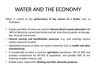
WATER AND THEECONOMY
Water is central to the performance of key sectors of a Nation such as
Zimbabwe.
• A large quantities of water are used for thermo-electric power generation (65
-80% of electricity comes from Kariba and bal. from thermal plants at Hwange,
Byo, Munyati and Harare);
• Mineral winning and beneficiation processes (e.g. coal washing) require
copious amounts of water;
• Substantial amounts of water are used in industries such as textile and other
manufacturing;
• A considerable of water is used for agriculture (constitutes 14% of GDP, and
provides employment for 60-70% of population, and provides 60% of raw
materials to other sectors); and
• Potable water required for drinking and other domestic purposes.
5.
WATER HEALTH ANDTHE ENVIRONMENT
• Water is essential for social development
• Safe water supply and sanitation underpins a
healthy, productive society and workforce.
6.
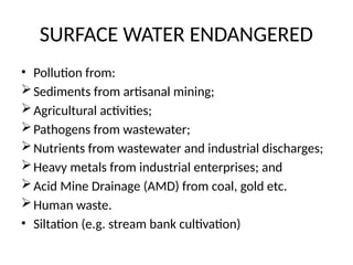
SURFACE WATER ENDANGERED
•Pollution from:
Sediments from artisanal mining;
Agricultural activities;
Pathogens from wastewater;
Nutrients from wastewater and industrial discharges;
Heavy metals from industrial enterprises; and
Acid Mine Drainage (AMD) from coal, gold etc.
Human waste.
• Siltation (e.g. stream bank cultivation)
7.
THREATS TO SURFACEWATER RESOURCES (CON’T)
• Climate Change - frequency and prolonged
droughts
• Increasing population – increased usage and
consequent pollution.
8.
THREATS TO WATERQUANTITY & QUALITY
Breakdown in water supply treatment and
waste water treatment, reduced capacity to
control contaminants in water supplies and
receiving waters, and
Deterioration of the natural environment’s
ability to reduce contaminants.
9.
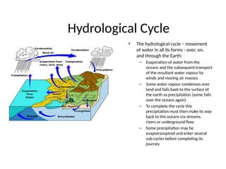
Hydrological Cycle
• Thehydrological cycle – movement
of water in all its forms - over, on,
and through the Earth:
– Evaporation of water from the
oceans and the subsequent transport
of the resultant water vapour by
winds and moving air masses
– Some water vapour condenses over
land and falls back to the surface of
the earth as precipitation (some falls
over the oceans again)
– To complete the cycle this
precipitation must then make its way
back to the oceans via streams,
rivers or underground flow.
– Some precipitation may be
evapotranspired and enter several
sub-cycles before completing its
journey
10.
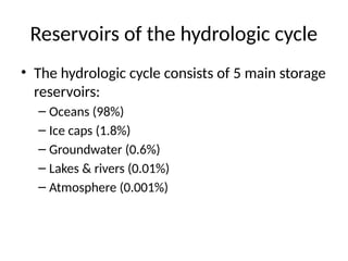
Reservoirs of thehydrologic cycle
• The hydrologic cycle consists of 5 main storage
reservoirs:
– Oceans (98%)
– Ice caps (1.8%)
– Groundwater (0.6%)
– Lakes & rivers (0.01%)
– Atmosphere (0.001%)
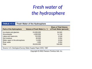
The world’s water
•Circa 3% of the worlds total water is available
to humans as fresh water.
• More than 95-98% of the available fresh
water is groundwater, which far exceeds the
volume of surface water.
13.
SOURCES OF GROUNDWATER
• “Rivers do not rise with the first rainfall; the
thirsty ground absorbs it all.” Seneca (A.D. 3 –
65).
14.
GROUNDWATER IMPORTANCE
• Humanity’smost important geological resource:
• International Association of Hydrologists, “Today a global
withdrawal of 600-700km3
/yr makes groundwater the world's
most extracted raw material”.
• “[groundwater] extraction has been and remains a cornerstone
of the Asian 'green agricultural revolution,' it also provides
about 70 percent of piped water supply in the European Union
and effectively supports rural communities across large areas of
Sub-Saharan Africa.”
(UN http://www.irinnews.org/webspecials/runningdry/default.asp)
• Groundwater provides water to 70% of Zimbabwe’s
population
15.
Hydrogeology & Hydrology
•In short Hydrogeology: study of the inter-
relationships of geologic materials, geologic
processes with water.
• Different from Hydrology: study of water -
occurrence, distribution, movement and
chemistry of all waters of the earth.
16.
GROUNDWATER IS ENDANGERED
•“According to some estimates, the amount of
water being used globally is more than twice
the quantity being recharged by rainfall every
year.
• India, China and Pakistan alone account for
more than half the world’s total use of
underground water for agriculture.
• Clearly, the level of current usage is
unsustainable.
17.
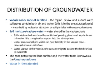
DISTRIBUTION OF GROUNDWATER
•Vadose zone/ zone of aeration – the region below land surface were
soil pores contain both air and water. (this is in the unsaturated zone)
– water held by molecular attraction on soil particles in the near-surface zone
• Soil moisture/vadose water – water stored in the vadose zone
– Soil moisture is drawn into the rootlets of growing plants and as plants use
this water it is transpired as vapour into the atmosphere.
– Under some conditions water can flow laterally in the vadose zone –
process known as interflow
– Water vapour in the vadose zone can also migrate back to the land surface
to evaporate
• The zone between the land surface and the water table is known as
the Unsaturated zone
• Water in the saturated
18.
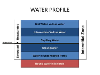
WATER PROFILE
Bound Waterin Minerals
Capillary Water
Intermediate Vadose Water
Water in Unconnected Pores
Groundwater
Soil Water/ vadose water
Interstitial
Zone
Saturated
Unsaturated
Water table
19.
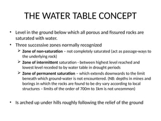
THE WATER TABLECONCEPT
• Level in the ground below which all porous and fissured rocks are
saturated with water.
• Three successive zones normally recognized
Zone of non-saturation – not completely saturated (act as passage-ways to
the underlying rock)
Zone of intermittent saturation - between highest level reached and
lowest level receded to by water table in drought periods
Zone of permanent saturation – which extends downwards to the limit
beneath which ground-water is not encountered. (NB: depths in mines and
borings in which the rocks are found to be dry vary according to local
structures – limits of the order of 700m to 1km is not uncommon)
• Is arched up under hills roughly following the relief of the ground
20.
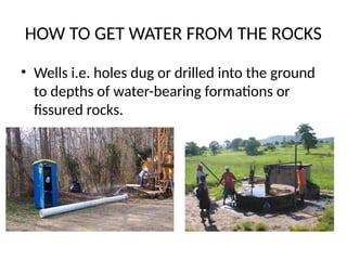
HOW TO GETWATER FROM THE ROCKS
• Wells i.e. holes dug or drilled into the ground
to depths of water-bearing formations or
fissured rocks.
21.
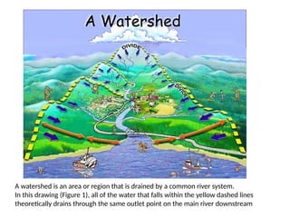
A watershed isan area or region that is drained by a common river system.
In this drawing (Figure 1), all of the water that falls within the yellow dashed lines
theoretically drains through the same outlet point on the main river downstream
22.
THE WATER BALANCECONCEPT
• Within a basin, water exists as:
– Precipitation,
– Surface water (or runoff),
– Groundwater (below ground),
– Reservoirs
– Evaporation.
• Assuming our basin is a closed system, we can apply the
principle of conservation of mass to our basin to come up with
an equation that tracks how much water is in each of these
storages/components.
• According to the conservation of mass:
Inputs-Outputs = Storage +-changes
23.
BALANCING THE HYDROLOGICEQUATION
• The basic unit of surface water hydrology is a drainage basin –
consists of all land area sloping toward a particular discharge
point.
• Drainage basin is outlined by surface water or topographic divides.
• In groundwater hydrology the term used is groundwater basin
which is the sub-surface volume through which groundwater flows
toward a specific discharge zone. It is surrounded by groundwater
divides.
• Boundaries of a surface water drainage basin and groundwater
basin do not necessarily coincide although water budget of an area
must account for both surface and sub-surface water in order to
perform a water budget analysis.
24.
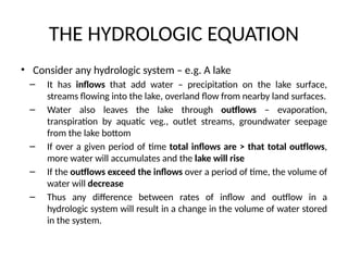
THE HYDROLOGIC EQUATION
•Consider any hydrologic system – e.g. A lake
– It has inflows that add water – precipitation on the lake surface,
streams flowing into the lake, overland flow from nearby land surfaces.
– Water also leaves the lake through outflows – evaporation,
transpiration by aquatic veg., outlet streams, groundwater seepage
from the lake bottom
– If over a given period of time total inflows are > that total outflows,
more water will accumulates and the lake will rise
– If the outflows exceed the inflows over a period of time, the volume of
water will decrease
– Thus any difference between rates of inflow and outflow in a
hydrologic system will result in a change in the volume of water stored
in the system.
25.
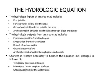
THE HYDROLOGIC EQUATION
•The hydrologic inputs of an area may include:
– Precipitation
– Surface water inflow into the area
– Groundwater inflow from outside the area
– Artificial import of water into the area through pipes and canals
• The hydrologic outputs from an area may include:
– Evapotranspiration from land areas
– Evaporation from surface water
– Runoff of surface water
– Groundwater outflow
– Artificial export of water through pipes and canals
• Changes in storage necessary to balance the equation incl. changes in
volume of:
– Temporary depression storage
– Intercepted water on plant surfaces
– Groundwater below the water table
26.
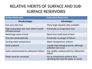
RELATIVE MERITS OFSURFACE AND SUB-
SURFACE RESERVOIRS
Surface Reservoirs Subsurface Reservoirs
Disadvantages Advantages
Few new sites free Many large-capacity sites available
High evaporative loss even where humid
climates prevail
Practically no evaporative loss
Need large areas of land Need very small areas of land
May fail catastrophically Practically no danger of failure
Varying water temperature Water temperature uniform
Easily polluted Usually high biological purity, although
pollution can occur
Easily contaminated by radioactive fallout Not rapidly contaminated by radioactive
fallout
Water must be conveyed Act as conveyance systems, thus
obviating the need for pipes or canals
27.
HYDROLOGISTS/HYDROGEOLOGISTS ROLE
• Surfacewater engineering / management
• Groundwater impact on Earth materials
properties (slope stability, subsurface
construction - subsidence)
• Water chemistry of groundwater
• Groundwater supply and wells
• Aquifer protection and remediation
• Environmental and groundwater law
28.
GROUNDWATER IS ENDANGERED(Zim
Scenario)
• Contamination of U/G water bodies by:
economic activity – mining particularly coal and
gold (AMD)
human waste especially as population increases
• Aquifer depletion by proliferation of bore-
holes; and
• Receding/ lowering of the water table due to
increase incidents or prolonged droughts
![GROUNDWATER IMPORTANCE
• Humanity’s most important geological resource:
• International Association of Hydrologists, “Today a global
withdrawal of 600-700km3
/yr makes groundwater the world's
most extracted raw material”.
• “[groundwater] extraction has been and remains a cornerstone
of the Asian 'green agricultural revolution,' it also provides
about 70 percent of piped water supply in the European Union
and effectively supports rural communities across large areas of
Sub-Saharan Africa.”
(UN http://www.irinnews.org/webspecials/runningdry/default.asp)
• Groundwater provides water to 70% of Zimbabwe’s
population](https://image.slidesharecdn.com/hydrogeologylecture1-250405181246-d3732267/85/Mining-Engineering-Hydrogeology-Lecture-1-pptx-14-320.jpg)