Engineering hydrology for civil Engineering student
1.
Hydrology
Hydrology is aGreek word: ‘Hydro’ means water and ‘logy’ means study. Thus,
Hydrology means the study of the science of water.
Hydrology is the ‘water science’ that deals with the occurrence, circulation and
distribution of water of the earth and earth’s atmosphere.
A good understanding of the hydrologic processes is important for the
assessment of the water resources, their management and conservation on
global and regional scales.
Hydrology can be classified as:
Scientific Hydrology – the study of the role of water in natural processes;
Engineering or Applied Hydrology – application (use and protection) of water
resources.
Engineering Hydrology deals with:
1. Study of the processes (rainfall, infiltration, runoff, evaporation etc.) and
their interactions.
2. Estimation of water resources (surface water and groundwater).
3. Study the hydrologic problems (floods, droughts, drainage etc.) and
mitigation measures.
Major branches ofHydrology are:
• Surface Water Hydrology - is the study of hydrologic processes that
operate at or near the earth's surface.
• Groundwater Hydrology - is the study of the presence and
movement of ground water.
• Ecohydrology - is the study of interactions between organisms and
the hydrologic cycle.
• Hydrometeorolgy - is the study of the transfer of water and energy
between land and water body surfaces and the lower atmosphere.
• Hydroinformatics - is the adaptation of information technology to
hydrology and water resources applications.
• Hydrometry – is concerned with the measurements of all the
variables in the hydrologic cycle.
• Hydrogeology – is the study of the relationships of geologic materials
and flowing water.
4.
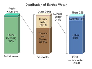
Some facts aboutwater:
• Water covers nearly three-fourths of the earth's surface.
• Out of the earth's total allotment of 1,386 million cubic km (M km3) of water:
- 97% is sea water
- 2% is frozen in polar ice caps.
- 0.6% is in aquifers deep below the earth's surface.
- 0.4% passes the planet's lakes and streams, is atmospheric moisture and is locked
within the bodies of living things.
• About 2.5% of world’s water is fresh water and only about 30% of it is both liquid and
fresh.
• Groundwater represents about 90% of the world's readily available liquid freshwater
resources, and some 1.5 billion people depend upon groundwater for their drinking
water (97% of people of Bangladesh depend on groundwater for drinking water).
• Agricultural water use accounts for about 75% of total global consumption, mainly
through crop irrigation, while industrial use accounts for about 20%, and the remaining
5% is used for domestic purposes. In Asia, almost 84% of the water withdrawal is used
for agricultural purposes (more than 95% in Bangladesh).
• It is estimated that the average person in developed countries uses 500-800 litres of
water per day, compared to 60-180 litres per day in developing countries.
5.
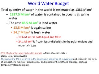
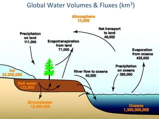
Total quantity ofwater in the world is estimated as 1386 Mkm3
– 1337.5 M km3 of water is contained in oceans as saline
water
– The rest 48.5 M km3 is land water
• 13.8 M km3 is again saline
• 34.7 M km3 is fresh water
– 10.6 M km3 is both liquid and fresh
– 24.1 M km3 is frozen ice and glaciers in the polar regions and
mountain tops
World Water Budget
99% of all earth's water is held in storage in form of oceans, lakes,
glacial ice or groundwater.
The remaining 1% is involved in the continuous sequence of movement and change in the form
of atmospheric moisture, precipitation, and subsequent runoff and drainage, perhaps
temporarily stored en route.
7.
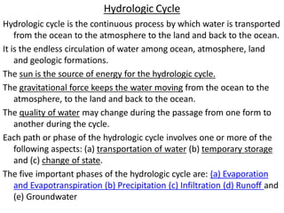
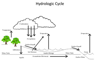
Hydrologic Cycle
Hydrologic cycleis the continuous process by which water is transported
from the ocean to the atmosphere to the land and back to the ocean.
It is the endless circulation of water among ocean, atmosphere, land
and geologic formations.
The sun is the source of energy for the hydrologic cycle.
The gravitational force keeps the water moving from the ocean to the
atmosphere, to the land and back to the ocean.
The quality of water may change during the passage from one form to
another during the cycle.
Each path or phase of the hydrologic cycle involves one or more of the
following aspects: (a) transportation of water (b) temporary storage
and (c) change of state.
The five important phases of the hydrologic cycle are: (a) Evaporation
and Evapotranspiration (b) Precipitation (c) Infiltration (d) Runoff and
(e) Groundwater
8.
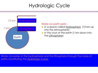
Hydrologic Cycle
Water onearth exists :
in a space called Hydrosphere (15 km up
into the atmosphere)
in the crust of the earth (1 km down into
the Lithosphere)
Lithosphere
Water circulates in the hydrosphere and the lithosphere through the maze of
paths constituting the Hydrologic Cycle.
Hydrosphere
15 km
1 km
Earth
Hydrologic Cycle
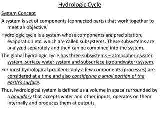
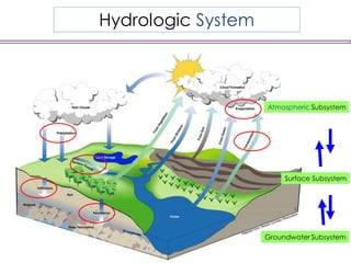
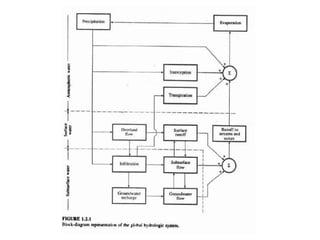
System Concept
Asystem is set of components (connected parts) that work together to
meet an objective.
Hydrologic cycle is a system whose components are precipitation,
evaporation etc. which are called subsystems. These subsystems are
analyzed separately and then can be combined into the system.
The global hydrologic cycle has three subsystems – atmospheric water
system, surface water system and subsurface (groundwater) system.
For most hydrological problems only a few components (processes) are
considered at a time and also considering a small portion of the
earth’s surface.
Thus, hydrological system is defined as a volume in space surrounded by
a boundary that accepts water and other inputs, operates on them
internally and produces them at outputs.
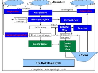
Precipitation
Water on SurfaceOverland Flow
Channel
Flow
The Hydrologic Cycle
Ground Water Ground
Water
Flow
Ocean
Reservoir
Atmosphere
Evaporation
Evapotranspiration
Evaporation
15.
Hydrologic Cycle
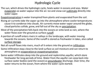
The sun,which drives the hydrologic cycle, heats water in oceans and seas. Water
evaporates as water vapour into the air. Ice and snow can sublimate directly into
water vapor.
Evapotranspiration is water transpired from plants and evaporated from the soil.
Rising air currents take the vapor up into the atmosphere where cooler temperatures
cause it to condense into clouds. Air currents move water vapor around the globe,
cloud particles collide, grow, and fall out of the sky as precipitation.
Most of the precipitation falls back into the oceans or onto land as rain, where the
water flows over the ground as surface runoff.
A portion of runoff enters rivers in valleys in the landscape, with water moving
towards the oceans. Some of the runoff is stored as freshwater in lakes, also called
surface storage.
Not all runoff flows into rivers, much of it enters into the ground as infiltration.
Some infiltration stays close to the land surface as soil moisture and can return to
atmosphere as evaporation or evapotranspiration.
Some water infiltrates deep into the ground and replenishes aquifer, which store
freshwater for long periods of time. Water from the aquifer can seep back into
surface-water bodies (and the ocean) as groundwater discharge. Over time, the
water returns to the ocean, from where the water cycle started.
16.
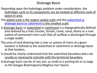
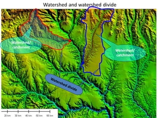
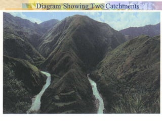
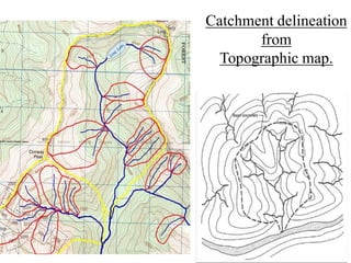
Drainage Basin
Depending uponthe hydrologic problem under consideration, the
hydrologic cycle or its components can be treated at different scale of
space or area.
The global scale is the largest spatial scale and the watershed or
drainage basin or catchment is the smallest scale.
A drainage basin or watershed or catchment is a topographically defined
area drained by a river (rivulet, stream, creek, canal, drain) or a river
system of connected rivers such that all outflow is discharged through
a single outlet.
The area of land draining into a river or system of rivers at a given
location is defined as the watershed or catchment or drainage basin
at that location.
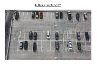
It should be clearly understood that the watershed boundary does not
usually or necessarily coincide with the territorial boundary.
A drainage basin can be of any size: as small as a parking lot or as large
as the Ganges-Brahmaputra-Meghna river basins.
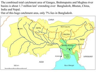
The combined totalcatchment area of Ganges, Brahmaputra and Meghna river
basins is about 1.7 million km2 extending over Bangladesh, Bhutan, China,
India and Nepal.
Out of this huge catchment area, only 7% lies in Bangladesh.
.
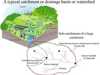
21.
A typical catchmentor drainage basin or watershed
A B
Stream Outlet B
Or Station B
Catchment boundary or watershed or divide for
the site at B
Stream Outlet A
Catchment boundary for
the site at A
Tributary
Sub-catchments of a large
catchment
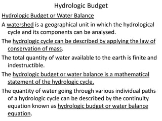
Hydrologic Budget
Hydrologic Budgetor Water Balance
A watershed is a geographical unit in which the hydrological
cycle and its components can be analysed.
The hydrologic cycle can be described by applying the law of
conservation of mass.
The total quantity of water available to the earth is finite and
indestructible.
The hydrologic budget or water balance is a mathematical
statement of the hydrologic cycle.
The quantity of water going through various individual paths
of a hydrologic cycle can be described by the continuity
equation known as hydrologic budget or water balance
equation.
24.
Water Budget Equation
•For a given catchment, in an interval of time ∆t, the
continuity equation for water in its various phases
can be given as:
Mass inflow – Mass outflow = Change in mass
storage
• If the density of the inflow, outflow and storage
volumes are the same:
Vi - Inflow volume in to the catchment, Vo - Outflow volume
from the catchment and ∆S - change in the water volume
S
o
i
25.
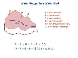
Water Budget ina Watershed
R
P
E
G
T
P - R - G - E - T = S
(P – R – G – E – T) / t = S/ t
P = precipitation
E = evaporation
T = transpiration
R = surface runoff
G = net groundwater flow
S = change in storage