SlideShare a Scribd company logo
MAR APRMAY MAYJUN JUNJUL JULAUG SEP SEPOCT OCTNOV NOVDEC DECJAN FEB
2013 20142014 2015
Public Input
& Research Master Planning
MPC + Uptown
Houston + HPARD
Interview Process
Programming
& Public Input
DesignTeam
Selection
MasterPlan
Presentation
MAR APRJAN FEB MAY
We are here
AUG
GuidingPrinciples
Presentation
PublicMeeting
InitialDesignConcepts
PUBLIC INPUT
GUIDING PRINCIPLES
RESEARCH
Berg Oliver (Ecology)
John Jacob (Soils)
Hunt Design (Wayfinding)
Sherwood Design Engineers
(Civil Engineering)
Susan Turner Associates (History)
The Lighting Practice (Lighting)
ETM Associates (O & M)
Ecotech Panel
Memorial Park Conservancy
Uptown TIRZ
Houston Parks and Recreation
Department
CLIENT INPUT
Access
Accessibility is valued highly,
including: entry points to the
Park; connectivity with other
parks and parts of the city, via
foot, bike, car, and mass transit;
and improved parking. Ease of
facilities use.
Balance
Balance—between nature and
recreation, and among the
needs of all “users” (human
and animal).
Enhancement of
Existing Character,
Amenities & Usage
Preserve and enhance Memorial
Park’s role as an “urban
wilderness”. Upgrading existing
amenities and add restrooms
and drinking fountains.
Safety & Security
Better safety/security at night
and for families; safety for
the various types of users;
management of vehicle/bike/
pedestrian traffic.
Communication
Need for stronger
communication, including:
ample and clear signage
and messaging about Park
offerings, ongoing public input/
involvement.
Long-term Sustainability
Preservation and protection
of flora and fauna; a resilient
ecology; employment of
sustainable practices; and
“green” facilities.
Individual & Community
Enrichment
Easy to connect to other
Houstonians as well as to the
story of Houston, including:
education programs; ways to
experience the Park’s location;
ways to socialize with others
and feel sense of community.
Houstonians Speak Up to Renew Memorial Park
In 2013, the Memorial Park Conservancy and its planning partners, Houston Parks and
Recreation Department, and Uptown TIRZ, launched a citywide public input process to
connect with current and future Memorial Park users. Multiple formats were used to offer
all Houstonians opportunities to contribute their viewpoints, including large public open
houses, small workshops, and 24/7 engagement through a Memorial Park Tomorrow
website and social media presence. The input from all of these, have enabled the team to
understand ways that people use the park now and would like to in the future.
The following broad public priorities are the result:
WELCOME !WELCOME !
Museum stories in
a movie theatre
Museum stories on TV and
radio, and in newspapers
and magazines
Traveling exhibitions
at local museums
WEWE
WELCOME !WELCOME !
Traveling exhibitions
at local museums
xhibitions
useums
WELCOME !WELCOME !
Museum stories in
a movie theatre
Museum stories on TV and
radio, and in newspapers
and magazines
Traveling exhibitions
at local museums
WELCOME !WELCOME !
Made possible with generous support from the Baxter Trust
Guiding Principles:
TEND
Memorial Park needs our care. Let’s be good stewards.
MAGNIFY
Memorial Park has a lot going for it. Let’s make those things more visible.
OPTIMIZE
Memorial Park’s parts are out of balance with each other. Let’s arrange them so the
park can function optimally.
RECONNECT
Memorial Park is divided in many ways. Let’s make it whole and plug it into life in
Houston.
REVEAL
Memorial Park holds stories relevant to all Houstonians. Let’s tell them to the world.
6   
SCALE: 1”=2000’
source: 1915 USFS Topographic map, altered for concept demonstration
Pre-1900: Undivided Land
•	 West of Houston’s developed extents, yet to be touched
by infrastructure or the thought of a park.
•	 1834: Reinerman Tract claimed (image right)
Legend
1925 Park boundary
(Hare  Hare)
1834 Reinerman Tract
14   
SCALE: 1”=2000’
Image: 2010 Aerial Photograph; Data: aerial photograph, Berg Oliver Associates, Susan Turner Associates
2010: 25 Parts
•	 The Living Bridge is constructed.
•	 Picnic loop is connected to Memorial Drive at a second
point further east, creating another fragment.
Site rails  roads
New roads
Adjacent roads
Buffalo Bayou
3
Legend
1 Bridle Trails
2 Golf Course
3 Arboretum  Nature Ctr.
4 Ravine  Woods
5 Median
6 Artillery/Infantry Woods
7 Green
8 Baseball
9 Playgrounds
10 Median
11 Median
12 Median
13 Picnic Loop
14 Rugby, green, trails
15 Weiss Park
16 Green
17 Median
18 Median
19 Median
20 Median
21 Median
22 Green / Median
23 Reynolds Woods
17
19
18
20
21
22
15
16
1 2
4
6
7 8
9
10
7
5
13
11
12
14
23
25
SCALE: 1”=2000’
Source: 2014 Lee Lupher aerial photograph
VISION: RECONNECTED PARK
• Stitch fragments together with contiguous spaces that
feel like a cohesive park
• Limit visual and pedestrian boundaries within the park
• Maintain existing programmatic elements of the park
Site rails  roads
Adjacent roads
Buffalo Bayou
Legend
VISION: LIMIT AREAS OF FUTURE IMPACT
• Areas in red indicate places that have been heavily impacted by previous development
excluding areas that are culturally or historically sensitive
• Goal: limit future development to areas that have already been altered by past development
SCALE: 1:24,000
Legend
Image: 2014 Google Aerial Photograph; Data: HRA Gray  Pape “In-
tensive Archaeological Survey of a 1.3-mile segment of Buffalo Bayou
in Harris County, Texas” with Roger Moore Archaeological Consulting;
Susan Turner Associates; and Berg Oliver
Historical  Cultural
Resources
Areas for future
impact
Land impacted by
foot traffic only
2014: EXISTING SITE ORGANIZATION
• The park is currently experienced as a series of smaller and discontiguous uses and typologies
Legend
Active recreation
Image: 2014 Google Aerial Photograph; Data: Houston
Parks and Recreation Department and aerial photo analysis
Urban Wilderness
(trail use)
Picnic Area
Historical  Cultural
Resources
Arboretum and Nature
Center
GOAL: CONNECT ACTIVE RECREATION AREAS
• Relocate active recreation such as baseball, rugby, and soccer that require more infrastructure and amenities such as parking and
bathrooms
• Combine areas of similar program, use and ecological, cultural, and historical experience
• Share recreation amenities for minimal impact on park and ease of maintenance
SCALE: 1:24,000
Legend
Image: 2014 Google Aerial Photograph; Data: Houston Parks and
Recreation Department and aerial photo analysis
Active recreation
Urban Wilderness
(trail use)
Picnic Areas
Cultural  Historical
Resources
Relocated active
recreation
Arboretum and Nature
Center
GOAL: LOCATE PICNIC AREAS THROUGHOUT PARK
• Picnic areas become moments to experience different parts of the park
• Accessible by car, bike, foot, or wheelchair
SCALE: 1:24,000
Legend
Image: 2014 Google Aerial Photograph; Data: Houston Parks and
Recreation Department and aerial photo analysis
Cultural  Historical
Resources
Dispersed picnic
areas
Active recreation
Urban Wilderness
(trail use)
Relocated active
recreation
Arboretum and Nature
Center
Picnic area
Dispersed picnic
areas
GOAL: CONNECT LAND MASSES
• Create trail areas that connect large swaths of the site, allowing for longer and more rich park experiences and greater ecological
connectivity
• Bridge currently divided parts of the park with green spaces trails that are appropriate to ecologically and historically sensitive
sites
SCALE: 1:24,000
Legend
Image: 2014 Google Aerial Photograph; Data: Houston Parks and
Recreation Department and aerial photo analysis
Active recreation
Urban Wilderness
(trail use)
Cultural  Historical
Resources
Relocated active
recreation
Connected wilderness
areas
Arboretum  Nature
Center
VISION: COHESIVE PARK PROGRAMS  EXPERIENCES
Envisioning a park that:
• Preserves and interprets Camp Logan’s richest and most productive archaeological areas
• Embraces the signature existing cultural and ecological resources
• Creates expansive, connected, and complimentary program areas that provide a cohesive experience of this 1500 acre park
SCALE: 1:24,000
Legend
Image: 2014 Google Aerial Photograph;
Active recreation
Relocated active
recreation
Urban Wilderness
(trail use)
Camp Logan
interpretive areas 
Historical entrance
experience
Golf course
Arboretum  Nature
Center
Dispersed picnic
areas
, 2014
Memorial Park
Houston, TX
Land Bridge - Perspective from Memorial Drive
Unaffected Areas
Affected Areas
Legend
Berg Oliver’s preliminary
assessment of areas negatively
impacted by recent drought and
hurricanes
VEGETATION: Preliminary Assessment
1000’0’ 2000’
Pine, Hardwoods Forest
Wet Prairie, Savanah
Upland Prairie, Savanah
Native Prairie
Savanah/Forest
Savanah
Savanah/Prairie
Unaffected Areas
Legend
By examining historical patterns
of vegetation, soils, hydrology,
and existing site conditions,
Berg Oliver developed these
preliminary recommendations
for the park’s restoration
strategy.
Initial Recommendations for Plant Community Restoration
1000’0’ 2000’
WOODLAND
100-150 trees/acre
25% shrubs
25% herbaceous
SAVANNAH
50 trees/acre
20% shrubs
70% herbaceous
PRAIRIE
5-10 trees/acre
20% shrubs
80% herbaceous
Plant Community Restoration Typologies
Riparian Forest
Pine-Hardwood Forest
Pine-Hardwood Savannah
Native Prairie
Naturalized Golf Course
Ponds and Stream Corridors
Wet Savannah and Pairie
Bog Areas
Legend
The design seeks to reconnect
what is now a patchwork of
ecological corridors. Continuous
flows of water, wildlife, and plant
communities will be restored
through restoration of four
restoration types:
1. Riparian forests along water
ways
2. Pine/Hardwood Forests
at park edges and in areas
physically appropriate to forest
restoration
3. Savannah landscapes in
much of the rest of the park
4. Discrete Native Prairie near
the center at the highest point
on the site.
RECONNECT, TEND  OPTIMIZE: Ecological Corridors  Program
1000’0’ 2000’
While road and rail networks
are integral parts of Memorial
Park and the park’s history
and current use, they interfere
with how the park functions as
an ecological whole and how
people and wildlife experience
these ecological zones.
Riparian Forest
Pine-Hardwood Forest
Pine-Hardwood Savannah
Native Prairie
Naturalized Golf Course
Ponds and Stream Corridors
Wet Savannah and Pairie
Bog Areas
Legend
Existing Corridor Roadblocks  Scattered Program
1000’0’ 2000’
Riparian Forest
Pine-Hardwood Forest
Pine-Hardwood Savannah
Native Prairie
Naturalized Golf Course
Ponds and Stream Corridors
Wet Savannah and Pairie
Bog Areas
Legend
Starting on the west edge of
the site, Memorial Park Drive
is realigned to hug the west
boundary of the park.
New bridges allow for physical
connection between the North
and south for water, wildlife, and
people.
Reconnect Western Riparian Corridor
1000’0’ 2000’
Riparian Forest
Pine-Hardwood Forest
Pine-Hardwood Savannah
Native Prairie
Naturalized Golf Course
Ponds and Stream Corridors
Wet Savannah and Pairie
Bog Areas
Legend
An access road and pedestrian
bridge over the railroad would
allow for further pedestrian
connection between the east
and west sides of the park.
Bridge Railroad for Pedestrians
1000’0’ 2000’
Riparian Forest
Pine-Hardwood Forest
Pine-Hardwood Savannah
Native Prairie
Naturalized Golf Course
Ponds and Stream Corridors
Wet Savannah and Pairie
Bog Areas
Legend
The picnic loop is removed to
enable connection between the
eastern and western halves of
the south side of the park.
Picnicking would be distributed
throughout the park.
Reclaim Savannah South of Memorial Drive
1000’0’ 2000’
Riparian Forest
Pine-Hardwood Forest
Pine-Hardwood Savannah
Native Prairie
Naturalized Golf Course
Ponds and Stream Corridors
Wet Savannah and Pairie
Bog Areas
Legend
Memorial Drive is reconstructed
with a bridge over the main
ravine, or barranco, allowing
for a north-south connection for
pedestrians, wildlife, and water.
Reconnect Riparian Corridor  Primary Barranco
1000’0’ 2000’
Riparian Forest
Pine-Hardwood Forest
Pine-Hardwood Savannah
Native Prairie
Naturalized Golf Course
Ponds and Stream Corridors
Wet Savannah and Pairie
Bog Areas
Legend
East Memorial Loop drive is
reconfigured to consolidate
park fragments and create
larger, usable central areas for
program.
Reclaim Eastern Fragments
1000’0’ 2000’
Riparian Forest
Pine-Hardwood Forest
Pine-Hardwood Savannah
Native Prairie
Naturalized Golf Course
Ponds and Stream Corridors
Wet Savannah and Pairie
Bog Areas
Legend
A land bridge across Memorial
Drive connects the northern and
southern halves of the park.
A unified park experience and
ecological corridors are created.
Bridge Northern  Southern Halves
1000’0’ 2000’
Riparian Forest
Pine-Hardwood Forest
Pine-Hardwood Savannah
Native Prairie
Naturalized Golf Course
Ponds and Stream Corridors
Wet Savannah and Pairie
Bog Areas
Legend
1. Rugby
2. Volleyball and Croquet
3. Soccer
4. Softball
5. Baseball
6. Driving Range
7. Softball
8. Tennis Center
9. Natatorium / Fitness
Active recreation fields, tennis
center, and driving range are
consolidated in the northeastern
section of the park, adjacent to
existing roads and development.
1
2
3 4 5
6
7
8
9
Optimize Sports in Less Ecologically Sensitive Areas
1000’0’ 2000’
Riparian Forest
Pine-Hardwood Forest
Pine-Hardwood Savannah
Native Prairie
Naturalized Golf Course
Ponds and Stream Corridors
Wet Savannah and Pairie
Bog Areas
Legend
Two existing ponds in the golf
course are expanded and
two new ponds are created to
collect and store site water.
Water will be used as amenities:
beautiful ponds as well as for
irrigation of the golf course,
ballfields, and lawn spaces.
These ponds will double as
wildlife habitat.
Gather Storm Water for Ponds, Irrigation  Ecological Health
1000’0’ 2000’
Riparian Forest
Pine-Hardwood Forest
Pine-Hardwood Savannah
Native Prairie
Naturalized Golf Course
Ponds and Stream Corridors
Wet Savannah and Pairie
Bog Areas
Legend
A bridge at the east end of
Memorial Drive provides another
safe connection between north
and south for pedestrians and a
celebrated entrance to the park.
Bridge and Accentuate East Entry
1000’0’ 2000’
Riparian Forest
Pine-Hardwood Forest
Pine-Hardwood Savannah
Native Prairie
Naturalized Golf Course
Ponds and Stream Corridors
Wet Savannah and Pairie
Bog Areas
Legend
REVEAL  MAGNIFY: Park History, Entries  Spaces
1000’0’ 2000’
Riparian Forest
Pine-Hardwood Forest
Pine-Hardwood Savannah
Native Prairie
Naturalized Golf Course
Ponds and Stream Corridors
Wet Savannah and Pairie
Bog Areas
Legend
Memorial Park’s First Master Plan
1924 Proposed Entry  Gardens
by Hare  Hare Landscape
Architects
Create a clearing in the forest.
Great Lawns, Gathering Spaces
1000’0’ 2000’
Riparian Forest
Pine-Hardwood Forest
Pine-Hardwood Savannah
Native Prairie
Naturalized Golf Course
Ponds and Stream Corridors
Wet Savannah and Pairie
Bog Areas
Legend
WWI Camp Logan Training Camp
Camp Logan Memorial Woods
1000’0’ 2000’
Riparian Forest
Pine-Hardwood Forest
Pine-Hardwood Savannah
Native Prairie
Naturalized Golf Course
Ponds and Stream Corridors
Wet Savannah and Pairie
Bog Areas
Legend
The northwest quadrant will
retain Equestrian trails. A
physically and visually disparate
Cycle Track that replaces the
Picnic Loop will solve user
conflict.
An equestrian center adjacent to
the polo grounds could house
possible Community Riding
Programs.
Equestrian Center, Trails  Cycle Track
1000’0’ 2000’
Riparian Forest
Pine-Hardwood Forest
Pine-Hardwood Savannah
Native Prairie
Naturalized Golf Course
Ponds and Stream Corridors
Wet Savannah and Pairie
Bog Areas
Legend
Wide and dense forested
buffers at the edges of the park
create a sense of immersion
in landscape spaces along the
more urbanized edges.
A landscaped berm on northern
edge at I-10 will help to buffer
noise and pollution.
Highway and Neighborhood Buffers
1000’0’ 2000’
Riparian Forest
Pine-Hardwood Forest
Pine-Hardwood Savannah
Native Prairie
Naturalized Golf Course
Ponds and Stream Corridors
Wet Savannah and Pairie
Bog Areas
Legend
Currently separated from the
park, this will become an iconic
entry. It provides access from
the west and the south to the
Arboretum and the park beyond.
This site will provide pedestrian
and boating access to the
bayou.
Reconnect Western Fragments, Celebrate Park Entry
1000’0’ 2000’
Riparian Forest
Pine-Hardwood Forest
Pine-Hardwood Savannah
Native Prairie
Naturalized Golf Course
Ponds and Stream Corridors
Wet Savannah and Pairie
Bog Areas
Legend
Access trails are added to Hogg
Bird Sanctuary. Invasive species
are cleared from the understory,
allowing for healthier habitat and
forage for native bird species.
Restore Hogg Bird Sanctuary
1000’0’ 2000’
Riparian Forest
Pine-Hardwood Forest
Pine-Hardwood Savannah
Native Prairie
Naturalized Golf Course
Ponds and Stream Corridors
Wet Savannah and Pairie
Bog Areas
Legend
Dispersed parking lots
provide improved access
to park activities. Parking
along Memorial Loop Road is
removed, allowing for two way
traffic and a more park-like
feeling. Discrete parking areas
now provide access to all parts
of the site.
The proposed parking design
provides no net loss in parking.
Proposed Parking Lots
Parking Service Areas
Existing Parking to Remain
Legend
Distribute Parking to Active Program Areas
1000’0’ 2000’
Riparian Forest
Pine-Hardwood Forest
Pine-Hardwood Savannah
Native Prairie
Naturalized Golf Course
Ponds and Stream Corridors
Wet Savannah and Pairie
Bog Areas
Legend
Vision: A park that balances
a more resilient natural
environment, improved
recreation and amenities,
and the site’s rich history and
setting.
REVEAL: Access to Diverse Spaces, Ecologies,  Cultural Resources
1000’0’ 2000’
Riparian Forest
Pine-Hardwood Forest
Pine-Hardwood Savannah
Native Prairie
Naturalized Golf Course
Ponds and Stream Corridors
Wet Savannah and Pairie
Bog Areas
Legend
Master Plan
Cycle Track and Trails
Archery
Equestrian Center
Sports Complex
Memorial Groves
Golf Course
Tennis Center
Fitness Center/Natatorium
Blossom and Arnot Multiuse Space
Maintenance Area
Hogg Bird Sanctuary
Family Recreation Area and Southside
Trailhead
Land Bridge
Running Trail Center and Timing Track
1000’0’ 2000’
PARKING LOT CROSSING
CONNECTIONONLYTHROUGHSLT
CONNECTION ON NORTH SIDE OF ROAD ONLY THROUGH SLT
Existing Trail Network
Multi Use Trail: 12.5 miles
Bridle Trails: 1.5 miles
Arboretum Trails: 6 miles
Outer Loop: 1.25 miles
Tex-DOT Trail: 1.75 miles
Cycle Track (picnic loop): 1.25 miles
Seymour Lieberman Trail: 2.9 miles
Total: 27.15 miles
1000’0’ 2000’
Proposed Trail Network: 50+ miles
1000’0’ 2000’
Pedestrian Trails: 40+ miles
1000’0’ 2000’
Connectivity Network: 7.5 miles
10-16'
1000’0’ 2000’
Memorial Loop: 9.5 miles
12’
1000’0’ 2000’
Seymour Lieberman Trail (SLT): 3 miles  Timing Track: .25 miles
16’
1000’0’ 2000’
Bayou Trail: 3 miles, Other Hiking  Running Trails: 8 miles
4’
1000’0’ 2000’
Arboretum Trails: 8 miles
20’
1000’0’ 2000’
Cycling Trails: 30+ miles
1000’0’ 2000’
Connectivity Network: 7.5 miles
16’
1000’0’ 2000’
Memorial Loop: 9.5 miles
12’
1000’0’ 2000’
Cycle Track: 1.5 miles, Kids Loop: .25 miles
24’
1000’0’ 2000’
Dedicated Mountain Bike: 8.5 miles, Kids Mountain Bike Zone: 1 mile
4’
1000’0’ 2000’
Equestrian Trails: 3.5 miles
12’
1000’0’ 2000’
Riparian Forest
Pine-Hardwood Forest
Pine-Hardwood Savannah
Native Prairie
Naturalized Golf Course
Ponds and Stream Corridors
Wet Savannah and Pairie
Bog Areas
Legend
Master Plan
Cycle Track and Trails
Archery
Equestrian Center
Sports Complex
Memorial Groves
Golf Course
Tennis Center
Fitness Center/Natatorium
Blossom and Arnot Multiuse Space
Maintenance Area
Hogg Bird Sanctuary
Family Recreation Area and Southside
Trailhead
Land Bridge
Running Trail Center and Timing Track
1000’0’ 2000’
Sports Complex
200’0’ 400’ 800’
Existing Conditions Aerial Photo
Sports Complex
200’0’ 400’ 800’
Existing Features to Remain
Sports Complex
200’0’ 400’ 800’
Driving Range (Double Height)
Sports Complex Sports Fields
Baseball
Softball
SoftballSoccer
Volleyball
Croquet
200’0’ 400’ 800’
Sports Complex Vegetated Berm and Buffer Planting
200’0’ 400’ 800’
Sports Complex Access Road
200’0’ 400’ 800’
Sports Complex Parking
200’0’ 400’ 800’
Sports Complex SLT
200’0’ 400’ 800’
Sports Complex Multiuse Trail
200’0’ 400’ 800’
Blossom and Arnot Multiuse Space Existing Conditions Aerial
200’0’ 400’ 800’
Blossom and Arnot Multiuse Space Natatorium
200’0’ 400’ 800’
Blossom and Arnot Multiuse Space Tennis and Fitness Center
200’0’ 400’ 800’
Blossom and Arnot Multiuse Space Blossom and Arnot Multiuse Spaces
200’0’ 400’ 800’
Blossom and Arnot Multiuse Space Buffer Planting
200’0’ 400’ 800’
Blossom and Arnot Multiuse Space Access Roads
200’0’ 400’ 800’
Blossom and Arnot Multiuse Space Parking
200’0’ 400’ 800’
Blossom and Arnot Multiuse Space SLT
200’0’ 400’ 800’
Blossom and Arnot Multiuse Space Multiuse Trail
200’0’ 400’ 800’
Land Bridge and Memorial Groves Existing Conditions Aerial Photo
200’0’ 400’ 800’
Land Bridge and Memorial Groves Existing Features to Remain
200’0’ 400’ 800’
Land Bridge and Memorial Groves Access Roads
200’0’ 400’ 800’
Land Bridge and Memorial Groves Land Bridge
200’0’ 400’ 800’
Land Bridge and Memorial Groves Parking
200’0’ 400’ 800’
Land Bridge and Memorial Groves Memorial Groves
200’0’ 400’ 800’
Land Bridge and Memorial Groves SLT and Timing Track
200’0’ 400’ 800’
Land Bridge and Memorial Groves Multiuse Trails
200’0’ 400’ 800’
Land Bridge and Memorial Groves Mountain Biking Trails
200’0’ 400’ 800’
Family Recreation Area and Southside Trailhead Existing Conditions Aerial Photo
200’0’ 400’ 800’
Family Recreation Area and Southside Trailhead Land Bridge and Access Roads
200’0’ 400’ 800’
Family Recreation Area and Southside Trailhead Parking
200’0’ 400’ 800’
Family Recreation Area and Southside Trailhead Trailhead Program
200’0’ 400’ 800’
Family Recreation Area and Southside Trailhead SLT
200’0’ 400’ 800’
Family Recreation Area and Southside Trailhead Multiuse Trail
200’0’ 400’ 800’
Family Recreation Area and Southside Trailhead Mountain Biking Trails
200’0’ 400’ 800’
Family Recreation Area and Southside Trailhead Hiking Trails
200’0’ 400’ 800’
Riparian Forest
Pine-Hardwood Forest
Pine-Hardwood Savannah
Native Prairie
Naturalized Golf Course
Ponds and Stream Corridors
Wet Savannah and Pairie
Bog Areas
Legend
Master Plan
Cycle Track and Trails
Archery
Equestrian Center
Sports Complex
Memorial Groves
Golf Course
Tennis Center
Fitness Center/Natatorium
Blossom and Arnot Multiuse Space
Maintenance Area
Hogg Bird Sanctuary
Family Recreation Area and Southside
Trailhead
Land Bridge
Running Trail Center and Timing Track
1000’0’ 2000’
69
45
8
8
90
59
610
610
610
610
69
8
8
8
8
10
45
1093
10
290
290
249
10
225
E
E
E
B
I
K
J
F
F
I
A
B
D
G
H
C
SPACES AND PLACES: HOW WILL IT LOOK?
Monday, January 12th, 2015, 6:30–8:30 pm
Moody Park Community Center
3725 Fulton St.
Houston, TX 77009
THE PROPOSED PLAN: MEMORIAL PARK TOMORROW
A PLACE FOR ALL HOUSTONIANS
Monday, March 9th, 2015, 6:30–8:30 pm
The Museum of Fine Arts, Houston
Brown Auditorium
Caroline Wiess Law Building
1001 Bissonnet St.
Houston, TX 77005
HOST: Council Member Ellen Cohen (District C)
A STORY OF THE PARK: PEOPLE IN NATURE
INITIAL DESIGN CONCEPTS
Wednesday, September 17th, 6–8 pm
The Eldorado Ballroom
2310 Elgin St.
Houston, TX 77004
HOST: Council Member Dwight Boykins (District D)
CO-HOST:Council Member Robert Gallegos (District I)
All Houstonians are welcome at all meetings
Join a meeting near you!
MASTER PLAN PUBLIC UPDATE MEETINGS
ORGANIZING THE SITE: WHAT GOES WHERE?
Monday, November 10th, 6:30–8:30 pm
White Oak Conference Center
7603 Antoine Dr.
Houston, TX 77088
HOST: Council Member Brenda Stardig (District A)
Memorial Park Tomorrow Nov.14

More Related Content

What's hot

Open house 2 aug 19 2014
Open house 2 aug 19 2014Open house 2 aug 19 2014
Open house 2 aug 19 2014
OV Consulting
 
Evergreen Trails Master Plan Open House #1
Evergreen Trails Master Plan Open House #1Evergreen Trails Master Plan Open House #1
Evergreen Trails Master Plan Open House #1
OV Consulting
 
Water Works Design Update - Presentation
Water Works Design Update - PresentationWater Works Design Update - Presentation
Water Works Design Update - Presentation
Minneapolis Parks Foundation
 
Fogvg program april 2014
Fogvg program april 2014Fogvg program april 2014
Fogvg program april 2014
Joan Schumaker
 
Clifton Avenue Streetscape Design - Posters
Clifton Avenue Streetscape Design - PostersClifton Avenue Streetscape Design - Posters
Clifton Avenue Streetscape Design - PostersJake Henderson
 
2010 UW-Madison Capstone
2010 UW-Madison Capstone2010 UW-Madison Capstone
2010 UW-Madison Capstone
adesmidt
 
Sustainable Tourism Report
Sustainable Tourism ReportSustainable Tourism Report
Sustainable Tourism ReportAndrew Brient
 
Chap 04
Chap 04Chap 04
Sheet1 renovated parksimilarity to poway park difference with poway
Sheet1 renovated parksimilarity to poway park difference with powaySheet1 renovated parksimilarity to poway park difference with poway
Sheet1 renovated parksimilarity to poway park difference with poway
mayank272369
 

What's hot (9)

Open house 2 aug 19 2014
Open house 2 aug 19 2014Open house 2 aug 19 2014
Open house 2 aug 19 2014
 
Evergreen Trails Master Plan Open House #1
Evergreen Trails Master Plan Open House #1Evergreen Trails Master Plan Open House #1
Evergreen Trails Master Plan Open House #1
 
Water Works Design Update - Presentation
Water Works Design Update - PresentationWater Works Design Update - Presentation
Water Works Design Update - Presentation
 
Fogvg program april 2014
Fogvg program april 2014Fogvg program april 2014
Fogvg program april 2014
 
Clifton Avenue Streetscape Design - Posters
Clifton Avenue Streetscape Design - PostersClifton Avenue Streetscape Design - Posters
Clifton Avenue Streetscape Design - Posters
 
2010 UW-Madison Capstone
2010 UW-Madison Capstone2010 UW-Madison Capstone
2010 UW-Madison Capstone
 
Sustainable Tourism Report
Sustainable Tourism ReportSustainable Tourism Report
Sustainable Tourism Report
 
Chap 04
Chap 04Chap 04
Chap 04
 
Sheet1 renovated parksimilarity to poway park difference with poway
Sheet1 renovated parksimilarity to poway park difference with powaySheet1 renovated parksimilarity to poway park difference with poway
Sheet1 renovated parksimilarity to poway park difference with poway
 

Viewers also liked

An investigation of supervision of television viewing as a factor
An investigation of supervision of television viewing as a factorAn investigation of supervision of television viewing as a factor
An investigation of supervision of television viewing as a factor
Alexander Decker
 
Preguntas de Didactica General, Lic Morataya
Preguntas de Didactica General, Lic MoratayaPreguntas de Didactica General, Lic Morataya
Preguntas de Didactica General, Lic Morataya
Yanira201545
 
VES CROWDFUNDING PRESS RELEASE #1
VES CROWDFUNDING PRESS RELEASE #1 VES CROWDFUNDING PRESS RELEASE #1
VES CROWDFUNDING PRESS RELEASE #1
José Alvarez Cornett
 
Gustar and Regular Present Tense Verbs Lesson
Gustar and Regular Present Tense Verbs LessonGustar and Regular Present Tense Verbs Lesson
Gustar and Regular Present Tense Verbs LessonBeth Carlson
 
SPICE MODEL of SCS210AGHR (Professional Model) in SPICE PARK
SPICE MODEL of SCS210AGHR (Professional Model) in SPICE PARKSPICE MODEL of SCS210AGHR (Professional Model) in SPICE PARK
SPICE MODEL of SCS210AGHR (Professional Model) in SPICE PARK
Tsuyoshi Horigome
 
Power Point Templates - 38 wedding
Power Point Templates - 38 weddingPower Point Templates - 38 wedding
Power Point Templates - 38 wedding
Oksana Selendeeva
 
Best i tekst 2016: Innhold og teknikk du trenger for å spre budskapet ditt
Best i tekst 2016: Innhold og teknikk du trenger for å spre budskapet dittBest i tekst 2016: Innhold og teknikk du trenger for å spre budskapet ditt
Best i tekst 2016: Innhold og teknikk du trenger for å spre budskapet ditt
Magnus Strømnes Bøe
 
Reuben Marketing Services Website Audit PowerPoint
Reuben Marketing Services Website Audit PowerPointReuben Marketing Services Website Audit PowerPoint
Reuben Marketing Services Website Audit PowerPoint
Fred Schafer
 
Magazine Inspiration
Magazine InspirationMagazine Inspiration
Magazine Inspiration
Taggar97
 
Bp Slide Show
Bp Slide ShowBp Slide Show
Bp Slide ShowRandyKeck
 
Trainingdigitalmktpublis 120720224706-phpapp01
Trainingdigitalmktpublis 120720224706-phpapp01Trainingdigitalmktpublis 120720224706-phpapp01
Trainingdigitalmktpublis 120720224706-phpapp01hoatuy
 
Knowledge Modeling in Various applications in Traffic Systems
Knowledge Modeling in Various applications in Traffic SystemsKnowledge Modeling in Various applications in Traffic Systems
Knowledge Modeling in Various applications in Traffic SystemsYomna Mahmoud Ibrahim Hassan
 

Viewers also liked (13)

Assignment 25
Assignment 25Assignment 25
Assignment 25
 
An investigation of supervision of television viewing as a factor
An investigation of supervision of television viewing as a factorAn investigation of supervision of television viewing as a factor
An investigation of supervision of television viewing as a factor
 
Preguntas de Didactica General, Lic Morataya
Preguntas de Didactica General, Lic MoratayaPreguntas de Didactica General, Lic Morataya
Preguntas de Didactica General, Lic Morataya
 
VES CROWDFUNDING PRESS RELEASE #1
VES CROWDFUNDING PRESS RELEASE #1 VES CROWDFUNDING PRESS RELEASE #1
VES CROWDFUNDING PRESS RELEASE #1
 
Gustar and Regular Present Tense Verbs Lesson
Gustar and Regular Present Tense Verbs LessonGustar and Regular Present Tense Verbs Lesson
Gustar and Regular Present Tense Verbs Lesson
 
SPICE MODEL of SCS210AGHR (Professional Model) in SPICE PARK
SPICE MODEL of SCS210AGHR (Professional Model) in SPICE PARKSPICE MODEL of SCS210AGHR (Professional Model) in SPICE PARK
SPICE MODEL of SCS210AGHR (Professional Model) in SPICE PARK
 
Power Point Templates - 38 wedding
Power Point Templates - 38 weddingPower Point Templates - 38 wedding
Power Point Templates - 38 wedding
 
Best i tekst 2016: Innhold og teknikk du trenger for å spre budskapet ditt
Best i tekst 2016: Innhold og teknikk du trenger for å spre budskapet dittBest i tekst 2016: Innhold og teknikk du trenger for å spre budskapet ditt
Best i tekst 2016: Innhold og teknikk du trenger for å spre budskapet ditt
 
Reuben Marketing Services Website Audit PowerPoint
Reuben Marketing Services Website Audit PowerPointReuben Marketing Services Website Audit PowerPoint
Reuben Marketing Services Website Audit PowerPoint
 
Magazine Inspiration
Magazine InspirationMagazine Inspiration
Magazine Inspiration
 
Bp Slide Show
Bp Slide ShowBp Slide Show
Bp Slide Show
 
Trainingdigitalmktpublis 120720224706-phpapp01
Trainingdigitalmktpublis 120720224706-phpapp01Trainingdigitalmktpublis 120720224706-phpapp01
Trainingdigitalmktpublis 120720224706-phpapp01
 
Knowledge Modeling in Various applications in Traffic Systems
Knowledge Modeling in Various applications in Traffic SystemsKnowledge Modeling in Various applications in Traffic Systems
Knowledge Modeling in Various applications in Traffic Systems
 

Similar to Memorial Park Tomorrow Nov.14

Memorial Park Tomorrow November 2014
Memorial Park Tomorrow November 2014Memorial Park Tomorrow November 2014
Memorial Park Tomorrow November 2014
MemParkTomorrow
 
Memorial Park Tomorrow January 2015
Memorial Park Tomorrow January 2015Memorial Park Tomorrow January 2015
Memorial Park Tomorrow January 2015
MemParkTomorrow
 
Memorial Park Tomorrow March 2015
Memorial Park Tomorrow March 2015Memorial Park Tomorrow March 2015
Memorial Park Tomorrow March 2015
MemParkTomorrow
 
Sherwin williams-land-use-programming
Sherwin williams-land-use-programmingSherwin williams-land-use-programming
Sherwin williams-land-use-programming
E'ville Eye
 
Slide Presentation from Public Update Meeting no.1 - A Story of the Park: Peo...
Slide Presentation from Public Update Meeting no.1 - A Story of the Park: Peo...Slide Presentation from Public Update Meeting no.1 - A Story of the Park: Peo...
Slide Presentation from Public Update Meeting no.1 - A Story of the Park: Peo...
MemParkTomorrow
 
Water Works Open House Presentation, Revised Design Concept - May 1st 2017
Water Works Open House Presentation, Revised Design Concept - May 1st 2017Water Works Open House Presentation, Revised Design Concept - May 1st 2017
Water Works Open House Presentation, Revised Design Concept - May 1st 2017
Minneapolis Parks Foundation
 
VanCortlandt_Park_User_Study
VanCortlandt_Park_User_StudyVanCortlandt_Park_User_Study
VanCortlandt_Park_User_StudyKatherine Brower
 
Reimagining Johnson Park- A Design Proposal for Swampscott, MA Cantell ● Faye...
Reimagining Johnson Park- A Design Proposal for Swampscott, MA Cantell ● Faye...Reimagining Johnson Park- A Design Proposal for Swampscott, MA Cantell ● Faye...
Reimagining Johnson Park- A Design Proposal for Swampscott, MA Cantell ● Faye...Anna (Cantell) McGinty
 
Portfolio_RobinMassingill_2015
Portfolio_RobinMassingill_2015Portfolio_RobinMassingill_2015
Portfolio_RobinMassingill_2015Robin Massingill
 
Maria Wainscott - Portfolio - 1.26.2014
Maria Wainscott - Portfolio - 1.26.2014Maria Wainscott - Portfolio - 1.26.2014
Maria Wainscott - Portfolio - 1.26.2014Maria Wainscott
 
KATEDEVOR_Portfolio
KATEDEVOR_PortfolioKATEDEVOR_Portfolio
KATEDEVOR_PortfolioKate Devor
 
DEE_Presentation July 1 2015
DEE_Presentation July 1 2015DEE_Presentation July 1 2015
DEE_Presentation July 1 2015Steven Diaz
 
Open Space Strategy
Open Space StrategyOpen Space Strategy
Open Space Strategy
City of Whittlesea
 
The Paterson Greenway Project
The Paterson Greenway ProjectThe Paterson Greenway Project
The Paterson Greenway Project
APA-NJ
 
Landfill Remediation Project - Student redesigns: Land Use Sustainable Develo...
Landfill Remediation Project - Student redesigns: Land Use Sustainable Develo...Landfill Remediation Project - Student redesigns: Land Use Sustainable Develo...
Landfill Remediation Project - Student redesigns: Land Use Sustainable Develo...
Andrea Drabicki
 
Redevelopment of Paprocany Waterfront
Redevelopment of Paprocany WaterfrontRedevelopment of Paprocany Waterfront
Redevelopment of Paprocany Waterfront
Divya Kothari
 
Rowan Park Community Overview
Rowan Park Community OverviewRowan Park Community Overview
Rowan Park Community Overview
BrookfieldRP
 
Slide Presentation from Public Update Meeting no.1 - A Story of the Park: Peo...
Slide Presentation from Public Update Meeting no.1 - A Story of the Park: Peo...Slide Presentation from Public Update Meeting no.1 - A Story of the Park: Peo...
Slide Presentation from Public Update Meeting no.1 - A Story of the Park: Peo...
MemParkTomorrow
 
The Future of Parks and Public Space
The Future of Parks and Public SpaceThe Future of Parks and Public Space
The Future of Parks and Public Space
Maria Gerstenberger
 
Oct 22, 2011 Cole Harbour Basin Open Spaces Plan
Oct 22, 2011 Cole Harbour Basin Open Spaces PlanOct 22, 2011 Cole Harbour Basin Open Spaces Plan
Oct 22, 2011 Cole Harbour Basin Open Spaces Plan
Plan TheBasin
 

Similar to Memorial Park Tomorrow Nov.14 (20)

Memorial Park Tomorrow November 2014
Memorial Park Tomorrow November 2014Memorial Park Tomorrow November 2014
Memorial Park Tomorrow November 2014
 
Memorial Park Tomorrow January 2015
Memorial Park Tomorrow January 2015Memorial Park Tomorrow January 2015
Memorial Park Tomorrow January 2015
 
Memorial Park Tomorrow March 2015
Memorial Park Tomorrow March 2015Memorial Park Tomorrow March 2015
Memorial Park Tomorrow March 2015
 
Sherwin williams-land-use-programming
Sherwin williams-land-use-programmingSherwin williams-land-use-programming
Sherwin williams-land-use-programming
 
Slide Presentation from Public Update Meeting no.1 - A Story of the Park: Peo...
Slide Presentation from Public Update Meeting no.1 - A Story of the Park: Peo...Slide Presentation from Public Update Meeting no.1 - A Story of the Park: Peo...
Slide Presentation from Public Update Meeting no.1 - A Story of the Park: Peo...
 
Water Works Open House Presentation, Revised Design Concept - May 1st 2017
Water Works Open House Presentation, Revised Design Concept - May 1st 2017Water Works Open House Presentation, Revised Design Concept - May 1st 2017
Water Works Open House Presentation, Revised Design Concept - May 1st 2017
 
VanCortlandt_Park_User_Study
VanCortlandt_Park_User_StudyVanCortlandt_Park_User_Study
VanCortlandt_Park_User_Study
 
Reimagining Johnson Park- A Design Proposal for Swampscott, MA Cantell ● Faye...
Reimagining Johnson Park- A Design Proposal for Swampscott, MA Cantell ● Faye...Reimagining Johnson Park- A Design Proposal for Swampscott, MA Cantell ● Faye...
Reimagining Johnson Park- A Design Proposal for Swampscott, MA Cantell ● Faye...
 
Portfolio_RobinMassingill_2015
Portfolio_RobinMassingill_2015Portfolio_RobinMassingill_2015
Portfolio_RobinMassingill_2015
 
Maria Wainscott - Portfolio - 1.26.2014
Maria Wainscott - Portfolio - 1.26.2014Maria Wainscott - Portfolio - 1.26.2014
Maria Wainscott - Portfolio - 1.26.2014
 
KATEDEVOR_Portfolio
KATEDEVOR_PortfolioKATEDEVOR_Portfolio
KATEDEVOR_Portfolio
 
DEE_Presentation July 1 2015
DEE_Presentation July 1 2015DEE_Presentation July 1 2015
DEE_Presentation July 1 2015
 
Open Space Strategy
Open Space StrategyOpen Space Strategy
Open Space Strategy
 
The Paterson Greenway Project
The Paterson Greenway ProjectThe Paterson Greenway Project
The Paterson Greenway Project
 
Landfill Remediation Project - Student redesigns: Land Use Sustainable Develo...
Landfill Remediation Project - Student redesigns: Land Use Sustainable Develo...Landfill Remediation Project - Student redesigns: Land Use Sustainable Develo...
Landfill Remediation Project - Student redesigns: Land Use Sustainable Develo...
 
Redevelopment of Paprocany Waterfront
Redevelopment of Paprocany WaterfrontRedevelopment of Paprocany Waterfront
Redevelopment of Paprocany Waterfront
 
Rowan Park Community Overview
Rowan Park Community OverviewRowan Park Community Overview
Rowan Park Community Overview
 
Slide Presentation from Public Update Meeting no.1 - A Story of the Park: Peo...
Slide Presentation from Public Update Meeting no.1 - A Story of the Park: Peo...Slide Presentation from Public Update Meeting no.1 - A Story of the Park: Peo...
Slide Presentation from Public Update Meeting no.1 - A Story of the Park: Peo...
 
The Future of Parks and Public Space
The Future of Parks and Public SpaceThe Future of Parks and Public Space
The Future of Parks and Public Space
 
Oct 22, 2011 Cole Harbour Basin Open Spaces Plan
Oct 22, 2011 Cole Harbour Basin Open Spaces PlanOct 22, 2011 Cole Harbour Basin Open Spaces Plan
Oct 22, 2011 Cole Harbour Basin Open Spaces Plan
 

Memorial Park Tomorrow Nov.14

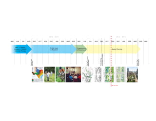
  • 1. MAR APRMAY MAYJUN JUNJUL JULAUG SEP SEPOCT OCTNOV NOVDEC DECJAN FEB 2013 20142014 2015 Public Input & Research Master Planning MPC + Uptown Houston + HPARD Interview Process Programming & Public Input DesignTeam Selection MasterPlan Presentation MAR APRJAN FEB MAY We are here AUG GuidingPrinciples Presentation PublicMeeting InitialDesignConcepts
  • 2. PUBLIC INPUT GUIDING PRINCIPLES RESEARCH Berg Oliver (Ecology) John Jacob (Soils) Hunt Design (Wayfinding) Sherwood Design Engineers (Civil Engineering) Susan Turner Associates (History) The Lighting Practice (Lighting) ETM Associates (O & M) Ecotech Panel Memorial Park Conservancy Uptown TIRZ Houston Parks and Recreation Department CLIENT INPUT
  • 3. Access Accessibility is valued highly, including: entry points to the Park; connectivity with other parks and parts of the city, via foot, bike, car, and mass transit; and improved parking. Ease of facilities use. Balance Balance—between nature and recreation, and among the needs of all “users” (human and animal). Enhancement of Existing Character, Amenities & Usage Preserve and enhance Memorial Park’s role as an “urban wilderness”. Upgrading existing amenities and add restrooms and drinking fountains. Safety & Security Better safety/security at night and for families; safety for the various types of users; management of vehicle/bike/ pedestrian traffic. Communication Need for stronger communication, including: ample and clear signage and messaging about Park offerings, ongoing public input/ involvement. Long-term Sustainability Preservation and protection of flora and fauna; a resilient ecology; employment of sustainable practices; and “green” facilities. Individual & Community Enrichment Easy to connect to other Houstonians as well as to the story of Houston, including: education programs; ways to experience the Park’s location; ways to socialize with others and feel sense of community. Houstonians Speak Up to Renew Memorial Park In 2013, the Memorial Park Conservancy and its planning partners, Houston Parks and Recreation Department, and Uptown TIRZ, launched a citywide public input process to connect with current and future Memorial Park users. Multiple formats were used to offer all Houstonians opportunities to contribute their viewpoints, including large public open houses, small workshops, and 24/7 engagement through a Memorial Park Tomorrow website and social media presence. The input from all of these, have enabled the team to understand ways that people use the park now and would like to in the future. The following broad public priorities are the result: WELCOME !WELCOME ! Museum stories in a movie theatre Museum stories on TV and radio, and in newspapers and magazines Traveling exhibitions at local museums WEWE WELCOME !WELCOME ! Traveling exhibitions at local museums xhibitions useums WELCOME !WELCOME ! Museum stories in a movie theatre Museum stories on TV and radio, and in newspapers and magazines Traveling exhibitions at local museums WELCOME !WELCOME ! Made possible with generous support from the Baxter Trust
  • 4. Guiding Principles: TEND Memorial Park needs our care. Let’s be good stewards. MAGNIFY Memorial Park has a lot going for it. Let’s make those things more visible. OPTIMIZE Memorial Park’s parts are out of balance with each other. Let’s arrange them so the park can function optimally. RECONNECT Memorial Park is divided in many ways. Let’s make it whole and plug it into life in Houston. REVEAL Memorial Park holds stories relevant to all Houstonians. Let’s tell them to the world.
  • 5. 6   SCALE: 1”=2000’ source: 1915 USFS Topographic map, altered for concept demonstration Pre-1900: Undivided Land • West of Houston’s developed extents, yet to be touched by infrastructure or the thought of a park. • 1834: Reinerman Tract claimed (image right) Legend 1925 Park boundary (Hare Hare) 1834 Reinerman Tract
  • 6. 14   SCALE: 1”=2000’ Image: 2010 Aerial Photograph; Data: aerial photograph, Berg Oliver Associates, Susan Turner Associates 2010: 25 Parts • The Living Bridge is constructed. • Picnic loop is connected to Memorial Drive at a second point further east, creating another fragment. Site rails roads New roads Adjacent roads Buffalo Bayou 3 Legend 1 Bridle Trails 2 Golf Course 3 Arboretum Nature Ctr. 4 Ravine Woods 5 Median 6 Artillery/Infantry Woods 7 Green 8 Baseball 9 Playgrounds 10 Median 11 Median 12 Median 13 Picnic Loop 14 Rugby, green, trails 15 Weiss Park 16 Green 17 Median 18 Median 19 Median 20 Median 21 Median 22 Green / Median 23 Reynolds Woods 17 19 18 20 21 22 15 16 1 2 4 6 7 8 9 10 7 5 13 11 12 14 23 25
  • 7. SCALE: 1”=2000’ Source: 2014 Lee Lupher aerial photograph VISION: RECONNECTED PARK • Stitch fragments together with contiguous spaces that feel like a cohesive park • Limit visual and pedestrian boundaries within the park • Maintain existing programmatic elements of the park Site rails roads Adjacent roads Buffalo Bayou Legend
  • 8. VISION: LIMIT AREAS OF FUTURE IMPACT • Areas in red indicate places that have been heavily impacted by previous development excluding areas that are culturally or historically sensitive • Goal: limit future development to areas that have already been altered by past development SCALE: 1:24,000 Legend Image: 2014 Google Aerial Photograph; Data: HRA Gray Pape “In- tensive Archaeological Survey of a 1.3-mile segment of Buffalo Bayou in Harris County, Texas” with Roger Moore Archaeological Consulting; Susan Turner Associates; and Berg Oliver Historical Cultural Resources Areas for future impact Land impacted by foot traffic only
  • 9. 2014: EXISTING SITE ORGANIZATION • The park is currently experienced as a series of smaller and discontiguous uses and typologies Legend Active recreation Image: 2014 Google Aerial Photograph; Data: Houston Parks and Recreation Department and aerial photo analysis Urban Wilderness (trail use) Picnic Area Historical Cultural Resources Arboretum and Nature Center
  • 10. GOAL: CONNECT ACTIVE RECREATION AREAS • Relocate active recreation such as baseball, rugby, and soccer that require more infrastructure and amenities such as parking and bathrooms • Combine areas of similar program, use and ecological, cultural, and historical experience • Share recreation amenities for minimal impact on park and ease of maintenance SCALE: 1:24,000 Legend Image: 2014 Google Aerial Photograph; Data: Houston Parks and Recreation Department and aerial photo analysis Active recreation Urban Wilderness (trail use) Picnic Areas Cultural Historical Resources Relocated active recreation Arboretum and Nature Center
  • 11. GOAL: LOCATE PICNIC AREAS THROUGHOUT PARK • Picnic areas become moments to experience different parts of the park • Accessible by car, bike, foot, or wheelchair SCALE: 1:24,000 Legend Image: 2014 Google Aerial Photograph; Data: Houston Parks and Recreation Department and aerial photo analysis Cultural Historical Resources Dispersed picnic areas Active recreation Urban Wilderness (trail use) Relocated active recreation Arboretum and Nature Center Picnic area
  • 12. Dispersed picnic areas GOAL: CONNECT LAND MASSES • Create trail areas that connect large swaths of the site, allowing for longer and more rich park experiences and greater ecological connectivity • Bridge currently divided parts of the park with green spaces trails that are appropriate to ecologically and historically sensitive sites SCALE: 1:24,000 Legend Image: 2014 Google Aerial Photograph; Data: Houston Parks and Recreation Department and aerial photo analysis Active recreation Urban Wilderness (trail use) Cultural Historical Resources Relocated active recreation Connected wilderness areas Arboretum Nature Center
  • 13. VISION: COHESIVE PARK PROGRAMS EXPERIENCES Envisioning a park that: • Preserves and interprets Camp Logan’s richest and most productive archaeological areas • Embraces the signature existing cultural and ecological resources • Creates expansive, connected, and complimentary program areas that provide a cohesive experience of this 1500 acre park SCALE: 1:24,000 Legend Image: 2014 Google Aerial Photograph; Active recreation Relocated active recreation Urban Wilderness (trail use) Camp Logan interpretive areas Historical entrance experience Golf course Arboretum Nature Center Dispersed picnic areas
  • 14.
  • 15. , 2014 Memorial Park Houston, TX Land Bridge - Perspective from Memorial Drive
  • 16. Unaffected Areas Affected Areas Legend Berg Oliver’s preliminary assessment of areas negatively impacted by recent drought and hurricanes VEGETATION: Preliminary Assessment 1000’0’ 2000’
  • 17. Pine, Hardwoods Forest Wet Prairie, Savanah Upland Prairie, Savanah Native Prairie Savanah/Forest Savanah Savanah/Prairie Unaffected Areas Legend By examining historical patterns of vegetation, soils, hydrology, and existing site conditions, Berg Oliver developed these preliminary recommendations for the park’s restoration strategy. Initial Recommendations for Plant Community Restoration 1000’0’ 2000’
  • 18. WOODLAND 100-150 trees/acre 25% shrubs 25% herbaceous SAVANNAH 50 trees/acre 20% shrubs 70% herbaceous PRAIRIE 5-10 trees/acre 20% shrubs 80% herbaceous Plant Community Restoration Typologies
  • 19. Riparian Forest Pine-Hardwood Forest Pine-Hardwood Savannah Native Prairie Naturalized Golf Course Ponds and Stream Corridors Wet Savannah and Pairie Bog Areas Legend The design seeks to reconnect what is now a patchwork of ecological corridors. Continuous flows of water, wildlife, and plant communities will be restored through restoration of four restoration types: 1. Riparian forests along water ways 2. Pine/Hardwood Forests at park edges and in areas physically appropriate to forest restoration 3. Savannah landscapes in much of the rest of the park 4. Discrete Native Prairie near the center at the highest point on the site. RECONNECT, TEND OPTIMIZE: Ecological Corridors Program 1000’0’ 2000’
  • 20. While road and rail networks are integral parts of Memorial Park and the park’s history and current use, they interfere with how the park functions as an ecological whole and how people and wildlife experience these ecological zones. Riparian Forest Pine-Hardwood Forest Pine-Hardwood Savannah Native Prairie Naturalized Golf Course Ponds and Stream Corridors Wet Savannah and Pairie Bog Areas Legend Existing Corridor Roadblocks Scattered Program 1000’0’ 2000’
  • 21. Riparian Forest Pine-Hardwood Forest Pine-Hardwood Savannah Native Prairie Naturalized Golf Course Ponds and Stream Corridors Wet Savannah and Pairie Bog Areas Legend Starting on the west edge of the site, Memorial Park Drive is realigned to hug the west boundary of the park. New bridges allow for physical connection between the North and south for water, wildlife, and people. Reconnect Western Riparian Corridor 1000’0’ 2000’
  • 22. Riparian Forest Pine-Hardwood Forest Pine-Hardwood Savannah Native Prairie Naturalized Golf Course Ponds and Stream Corridors Wet Savannah and Pairie Bog Areas Legend An access road and pedestrian bridge over the railroad would allow for further pedestrian connection between the east and west sides of the park. Bridge Railroad for Pedestrians 1000’0’ 2000’
  • 23. Riparian Forest Pine-Hardwood Forest Pine-Hardwood Savannah Native Prairie Naturalized Golf Course Ponds and Stream Corridors Wet Savannah and Pairie Bog Areas Legend The picnic loop is removed to enable connection between the eastern and western halves of the south side of the park. Picnicking would be distributed throughout the park. Reclaim Savannah South of Memorial Drive 1000’0’ 2000’
  • 24. Riparian Forest Pine-Hardwood Forest Pine-Hardwood Savannah Native Prairie Naturalized Golf Course Ponds and Stream Corridors Wet Savannah and Pairie Bog Areas Legend Memorial Drive is reconstructed with a bridge over the main ravine, or barranco, allowing for a north-south connection for pedestrians, wildlife, and water. Reconnect Riparian Corridor Primary Barranco 1000’0’ 2000’
  • 25. Riparian Forest Pine-Hardwood Forest Pine-Hardwood Savannah Native Prairie Naturalized Golf Course Ponds and Stream Corridors Wet Savannah and Pairie Bog Areas Legend East Memorial Loop drive is reconfigured to consolidate park fragments and create larger, usable central areas for program. Reclaim Eastern Fragments 1000’0’ 2000’
  • 26. Riparian Forest Pine-Hardwood Forest Pine-Hardwood Savannah Native Prairie Naturalized Golf Course Ponds and Stream Corridors Wet Savannah and Pairie Bog Areas Legend A land bridge across Memorial Drive connects the northern and southern halves of the park. A unified park experience and ecological corridors are created. Bridge Northern Southern Halves 1000’0’ 2000’
  • 27.
  • 28. Riparian Forest Pine-Hardwood Forest Pine-Hardwood Savannah Native Prairie Naturalized Golf Course Ponds and Stream Corridors Wet Savannah and Pairie Bog Areas Legend 1. Rugby 2. Volleyball and Croquet 3. Soccer 4. Softball 5. Baseball 6. Driving Range 7. Softball 8. Tennis Center 9. Natatorium / Fitness Active recreation fields, tennis center, and driving range are consolidated in the northeastern section of the park, adjacent to existing roads and development. 1 2 3 4 5 6 7 8 9 Optimize Sports in Less Ecologically Sensitive Areas 1000’0’ 2000’
  • 29. Riparian Forest Pine-Hardwood Forest Pine-Hardwood Savannah Native Prairie Naturalized Golf Course Ponds and Stream Corridors Wet Savannah and Pairie Bog Areas Legend Two existing ponds in the golf course are expanded and two new ponds are created to collect and store site water. Water will be used as amenities: beautiful ponds as well as for irrigation of the golf course, ballfields, and lawn spaces. These ponds will double as wildlife habitat. Gather Storm Water for Ponds, Irrigation Ecological Health 1000’0’ 2000’
  • 30. Riparian Forest Pine-Hardwood Forest Pine-Hardwood Savannah Native Prairie Naturalized Golf Course Ponds and Stream Corridors Wet Savannah and Pairie Bog Areas Legend A bridge at the east end of Memorial Drive provides another safe connection between north and south for pedestrians and a celebrated entrance to the park. Bridge and Accentuate East Entry 1000’0’ 2000’
  • 31. Riparian Forest Pine-Hardwood Forest Pine-Hardwood Savannah Native Prairie Naturalized Golf Course Ponds and Stream Corridors Wet Savannah and Pairie Bog Areas Legend REVEAL MAGNIFY: Park History, Entries Spaces 1000’0’ 2000’
  • 32. Riparian Forest Pine-Hardwood Forest Pine-Hardwood Savannah Native Prairie Naturalized Golf Course Ponds and Stream Corridors Wet Savannah and Pairie Bog Areas Legend Memorial Park’s First Master Plan 1924 Proposed Entry Gardens by Hare Hare Landscape Architects Create a clearing in the forest. Great Lawns, Gathering Spaces 1000’0’ 2000’
  • 33. Riparian Forest Pine-Hardwood Forest Pine-Hardwood Savannah Native Prairie Naturalized Golf Course Ponds and Stream Corridors Wet Savannah and Pairie Bog Areas Legend WWI Camp Logan Training Camp Camp Logan Memorial Woods 1000’0’ 2000’
  • 34. Riparian Forest Pine-Hardwood Forest Pine-Hardwood Savannah Native Prairie Naturalized Golf Course Ponds and Stream Corridors Wet Savannah and Pairie Bog Areas Legend The northwest quadrant will retain Equestrian trails. A physically and visually disparate Cycle Track that replaces the Picnic Loop will solve user conflict. An equestrian center adjacent to the polo grounds could house possible Community Riding Programs. Equestrian Center, Trails Cycle Track 1000’0’ 2000’
  • 35. Riparian Forest Pine-Hardwood Forest Pine-Hardwood Savannah Native Prairie Naturalized Golf Course Ponds and Stream Corridors Wet Savannah and Pairie Bog Areas Legend Wide and dense forested buffers at the edges of the park create a sense of immersion in landscape spaces along the more urbanized edges. A landscaped berm on northern edge at I-10 will help to buffer noise and pollution. Highway and Neighborhood Buffers 1000’0’ 2000’
  • 36. Riparian Forest Pine-Hardwood Forest Pine-Hardwood Savannah Native Prairie Naturalized Golf Course Ponds and Stream Corridors Wet Savannah and Pairie Bog Areas Legend Currently separated from the park, this will become an iconic entry. It provides access from the west and the south to the Arboretum and the park beyond. This site will provide pedestrian and boating access to the bayou. Reconnect Western Fragments, Celebrate Park Entry 1000’0’ 2000’
  • 37. Riparian Forest Pine-Hardwood Forest Pine-Hardwood Savannah Native Prairie Naturalized Golf Course Ponds and Stream Corridors Wet Savannah and Pairie Bog Areas Legend Access trails are added to Hogg Bird Sanctuary. Invasive species are cleared from the understory, allowing for healthier habitat and forage for native bird species. Restore Hogg Bird Sanctuary 1000’0’ 2000’
  • 38. Riparian Forest Pine-Hardwood Forest Pine-Hardwood Savannah Native Prairie Naturalized Golf Course Ponds and Stream Corridors Wet Savannah and Pairie Bog Areas Legend Dispersed parking lots provide improved access to park activities. Parking along Memorial Loop Road is removed, allowing for two way traffic and a more park-like feeling. Discrete parking areas now provide access to all parts of the site. The proposed parking design provides no net loss in parking. Proposed Parking Lots Parking Service Areas Existing Parking to Remain Legend Distribute Parking to Active Program Areas 1000’0’ 2000’
  • 39. Riparian Forest Pine-Hardwood Forest Pine-Hardwood Savannah Native Prairie Naturalized Golf Course Ponds and Stream Corridors Wet Savannah and Pairie Bog Areas Legend Vision: A park that balances a more resilient natural environment, improved recreation and amenities, and the site’s rich history and setting. REVEAL: Access to Diverse Spaces, Ecologies, Cultural Resources 1000’0’ 2000’
  • 40. Riparian Forest Pine-Hardwood Forest Pine-Hardwood Savannah Native Prairie Naturalized Golf Course Ponds and Stream Corridors Wet Savannah and Pairie Bog Areas Legend Master Plan Cycle Track and Trails Archery Equestrian Center Sports Complex Memorial Groves Golf Course Tennis Center Fitness Center/Natatorium Blossom and Arnot Multiuse Space Maintenance Area Hogg Bird Sanctuary Family Recreation Area and Southside Trailhead Land Bridge Running Trail Center and Timing Track 1000’0’ 2000’
  • 41. PARKING LOT CROSSING CONNECTIONONLYTHROUGHSLT CONNECTION ON NORTH SIDE OF ROAD ONLY THROUGH SLT Existing Trail Network Multi Use Trail: 12.5 miles Bridle Trails: 1.5 miles Arboretum Trails: 6 miles Outer Loop: 1.25 miles Tex-DOT Trail: 1.75 miles Cycle Track (picnic loop): 1.25 miles Seymour Lieberman Trail: 2.9 miles Total: 27.15 miles 1000’0’ 2000’
  • 42. Proposed Trail Network: 50+ miles 1000’0’ 2000’
  • 43. Pedestrian Trails: 40+ miles 1000’0’ 2000’
  • 44. Connectivity Network: 7.5 miles 10-16' 1000’0’ 2000’
  • 45. Memorial Loop: 9.5 miles 12’ 1000’0’ 2000’
  • 46. Seymour Lieberman Trail (SLT): 3 miles Timing Track: .25 miles 16’ 1000’0’ 2000’
  • 47. Bayou Trail: 3 miles, Other Hiking Running Trails: 8 miles 4’ 1000’0’ 2000’
  • 48. Arboretum Trails: 8 miles 20’ 1000’0’ 2000’
  • 49. Cycling Trails: 30+ miles 1000’0’ 2000’
  • 50. Connectivity Network: 7.5 miles 16’ 1000’0’ 2000’
  • 51. Memorial Loop: 9.5 miles 12’ 1000’0’ 2000’
  • 52. Cycle Track: 1.5 miles, Kids Loop: .25 miles 24’ 1000’0’ 2000’
  • 53. Dedicated Mountain Bike: 8.5 miles, Kids Mountain Bike Zone: 1 mile 4’ 1000’0’ 2000’
  • 54. Equestrian Trails: 3.5 miles 12’ 1000’0’ 2000’
  • 55. Riparian Forest Pine-Hardwood Forest Pine-Hardwood Savannah Native Prairie Naturalized Golf Course Ponds and Stream Corridors Wet Savannah and Pairie Bog Areas Legend Master Plan Cycle Track and Trails Archery Equestrian Center Sports Complex Memorial Groves Golf Course Tennis Center Fitness Center/Natatorium Blossom and Arnot Multiuse Space Maintenance Area Hogg Bird Sanctuary Family Recreation Area and Southside Trailhead Land Bridge Running Trail Center and Timing Track 1000’0’ 2000’
  • 56. Sports Complex 200’0’ 400’ 800’ Existing Conditions Aerial Photo
  • 57. Sports Complex 200’0’ 400’ 800’ Existing Features to Remain
  • 58. Sports Complex 200’0’ 400’ 800’ Driving Range (Double Height)
  • 59. Sports Complex Sports Fields Baseball Softball SoftballSoccer Volleyball Croquet 200’0’ 400’ 800’
  • 60. Sports Complex Vegetated Berm and Buffer Planting 200’0’ 400’ 800’
  • 61. Sports Complex Access Road 200’0’ 400’ 800’
  • 64. Sports Complex Multiuse Trail 200’0’ 400’ 800’
  • 65. Blossom and Arnot Multiuse Space Existing Conditions Aerial 200’0’ 400’ 800’
  • 66. Blossom and Arnot Multiuse Space Natatorium 200’0’ 400’ 800’
  • 67. Blossom and Arnot Multiuse Space Tennis and Fitness Center 200’0’ 400’ 800’
  • 68. Blossom and Arnot Multiuse Space Blossom and Arnot Multiuse Spaces 200’0’ 400’ 800’
  • 69. Blossom and Arnot Multiuse Space Buffer Planting 200’0’ 400’ 800’
  • 70. Blossom and Arnot Multiuse Space Access Roads 200’0’ 400’ 800’
  • 71. Blossom and Arnot Multiuse Space Parking 200’0’ 400’ 800’
  • 72. Blossom and Arnot Multiuse Space SLT 200’0’ 400’ 800’
  • 73. Blossom and Arnot Multiuse Space Multiuse Trail 200’0’ 400’ 800’
  • 74. Land Bridge and Memorial Groves Existing Conditions Aerial Photo 200’0’ 400’ 800’
  • 75. Land Bridge and Memorial Groves Existing Features to Remain 200’0’ 400’ 800’
  • 76. Land Bridge and Memorial Groves Access Roads 200’0’ 400’ 800’
  • 77. Land Bridge and Memorial Groves Land Bridge 200’0’ 400’ 800’
  • 78. Land Bridge and Memorial Groves Parking 200’0’ 400’ 800’
  • 79. Land Bridge and Memorial Groves Memorial Groves 200’0’ 400’ 800’
  • 80. Land Bridge and Memorial Groves SLT and Timing Track 200’0’ 400’ 800’
  • 81. Land Bridge and Memorial Groves Multiuse Trails 200’0’ 400’ 800’
  • 82. Land Bridge and Memorial Groves Mountain Biking Trails 200’0’ 400’ 800’
  • 83. Family Recreation Area and Southside Trailhead Existing Conditions Aerial Photo 200’0’ 400’ 800’
  • 84. Family Recreation Area and Southside Trailhead Land Bridge and Access Roads 200’0’ 400’ 800’
  • 85. Family Recreation Area and Southside Trailhead Parking 200’0’ 400’ 800’
  • 86. Family Recreation Area and Southside Trailhead Trailhead Program 200’0’ 400’ 800’
  • 87. Family Recreation Area and Southside Trailhead SLT 200’0’ 400’ 800’
  • 88. Family Recreation Area and Southside Trailhead Multiuse Trail 200’0’ 400’ 800’
  • 89. Family Recreation Area and Southside Trailhead Mountain Biking Trails 200’0’ 400’ 800’
  • 90. Family Recreation Area and Southside Trailhead Hiking Trails 200’0’ 400’ 800’
  • 91. Riparian Forest Pine-Hardwood Forest Pine-Hardwood Savannah Native Prairie Naturalized Golf Course Ponds and Stream Corridors Wet Savannah and Pairie Bog Areas Legend Master Plan Cycle Track and Trails Archery Equestrian Center Sports Complex Memorial Groves Golf Course Tennis Center Fitness Center/Natatorium Blossom and Arnot Multiuse Space Maintenance Area Hogg Bird Sanctuary Family Recreation Area and Southside Trailhead Land Bridge Running Trail Center and Timing Track 1000’0’ 2000’
  • 92. 69 45 8 8 90 59 610 610 610 610 69 8 8 8 8 10 45 1093 10 290 290 249 10 225 E E E B I K J F F I A B D G H C SPACES AND PLACES: HOW WILL IT LOOK? Monday, January 12th, 2015, 6:30–8:30 pm Moody Park Community Center 3725 Fulton St. Houston, TX 77009 THE PROPOSED PLAN: MEMORIAL PARK TOMORROW A PLACE FOR ALL HOUSTONIANS Monday, March 9th, 2015, 6:30–8:30 pm The Museum of Fine Arts, Houston Brown Auditorium Caroline Wiess Law Building 1001 Bissonnet St. Houston, TX 77005 HOST: Council Member Ellen Cohen (District C) A STORY OF THE PARK: PEOPLE IN NATURE INITIAL DESIGN CONCEPTS Wednesday, September 17th, 6–8 pm The Eldorado Ballroom 2310 Elgin St. Houston, TX 77004 HOST: Council Member Dwight Boykins (District D) CO-HOST:Council Member Robert Gallegos (District I) All Houstonians are welcome at all meetings Join a meeting near you! MASTER PLAN PUBLIC UPDATE MEETINGS ORGANIZING THE SITE: WHAT GOES WHERE? Monday, November 10th, 6:30–8:30 pm White Oak Conference Center 7603 Antoine Dr. Houston, TX 77088 HOST: Council Member Brenda Stardig (District A)