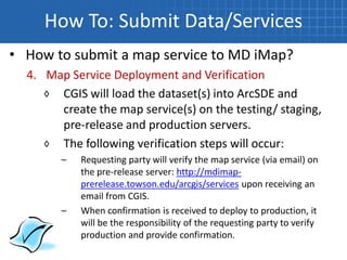
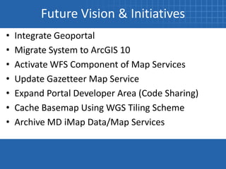
MD iMap
One Maryland – One Map: Maryland Integrated Map


                    Julia Lukens, GIS Coordinator, DBED
Scott Jeffrey, Program Director, Geospatial Applications Program at CCBC
                   Ashley Buzzeo, Project Manager, CGIS
Presentation Outline
• What is MD iMap?
• 2010 Accomplishments
• How To:
  ◊   Find Data & Services
  ◊   Make A Map
  ◊   Submit Data/Services
  ◊   Submit Applications
• Future Vision & Initiatives
What is MD iMap?
What is MD iMap?
Vision for MD iMap:
“MD iMap is the spatial
data repository to
satisfy the needs of
public and private
agencies and to
enhance state, regional
and local planning
initiatives and
collaboration.”           http://imap.maryland.gov
What is MD iMap?
MD iMap Resources:
• Portal
• Infrastructure
• Authoritative Source
• Basemaps
• Data/Information
• Applications/Tools
• Centralized Interface   http://imap.maryland.gov
2010 Accomplishments
Applications:
• 17 Online Mapping Applications Now Accessible
• 8 New 2010 Applications


 DHMH – 2/2010      DBED – 5/2010    MDOT – 6/2010   DNR – 6/2010


 DNR – 6/2010       MD BB – 8/2010   MDE – 10/2010   DNR – 11/2010
2010 Accomplishments
System Usage:
• 202,976 Unique Page Visits


22,405 Visits   11,526 Visits   10,466 Visits   9,547 Visits   7,613 Visits

System Access:
• 95% Users Access via Online Applications
• 5% Users Access via Desktop Services
2010 Accomplishments
Map Services:
• 183 Map Services Now Available
• 129 New 2010 Map Services

                                         Parcel Boundaries


Cable Modem
  Broadband            Ocean Wind
 Service Area         Power (100m)     Tree
                                     Plantings
2010 Accomplishments
Map Services Usage:
• ISO ImageryBasemapsEarthCover
  ◊ 10,019,725 Total Hits

• ISO PlanningCadastre
  ◊ 2,006,023 Total Hits

• ISO GeocodeServices
  ◊ 1,970,118 Total Hits
2010 Accomplishments
Map Services ISO Categories:
•   Biota                           •   Health
•   Boundaries                      •   ImageryBaseMapsEarthCover
•   ClimatologyMeterologyAtmosphere •   InlandWaters
•   Economy                         •   IntelligenceMilitary
•   Elevation                       •   Location
•   Environment                     •   Oceans
•   Farming                         •   PlanningCadastre
•   GeocodeServices                 •   Society
•   GeometryService                 •   Structure
•   GeoprocessingServices           •   Transportation
•   GeoscientificInformation        •   UtilitiesCommunication
2010 Accomplishments
Map Services ISO Categories:
• Biota                            • Location
   ◊ Fish Spawn Area                  ◊ USGS Topo Map Grids
   ◊ Salt Marsh                    • Oceans
• Elevation                           ◊ Shoreline Rates of Change
   ◊ Bay Depth                        ◊ Artificial Reefs
• Farming                          • Society
   ◊ Priority Preservation Areas      ◊ Nat. Register of Historic
• InlandWaters                           Places
   ◊ DNR Wetlands                     ◊ Population Density 2009
   ◊ Tier II Waters                • Transportation
   ◊ Watersheds                       ◊ Offshore Shipping Lanes
2010 Accomplishments
Technical Committee:
• Forum for coordination and communication of
  Statewide GIS activities
• Meetings held 1st & 3rd Tuesdays from 1 – 3p.m.
  @ MDE (Montgomery Park)
• Four Subcommittees:
  ◊ Application, Data & Resources, Outreach &
    Education and Security
2010 Accomplishments
Technical Committee Participation:             Agency
                                                 MDA
                                            Baltimore City
                                                                 Meeting Hours
                                                                      18
                                                                       2

• 29 Different Agencies
                                          Baltimore County            26
                                                 BMC                  22
                                                 CCBC                 18
                                                 CGIS                 38
  ◊ Regional, State, Local and Private           CSSC
                                                 DBED
                                                                       2
                                                                      30

    Companies                                   DHCD
                                                  DJS
                                                 DNR
                                                                      24
                                                                      30
                                                                      24

• Estimate of 3,200 staff hours were
                                                 DOIT                 22
                                                ESRGC                  2
                                                 ESRI                  6

  contributed in 2010                     Frederick County            10
                                           Howard County               2
                                                  KCI                  2
                                                Laurel                 2
                                          MD Poison Center            10
                                                 MDE                  32
                                                 MDP                  36
                                                MDTA                  22
                                                MEMA                   6
                                                 MES                  16
                                                 MHT                   2
                                         Montgomery County             2
                                                 MSP                   4
                                         Queen Anne's County           2
                                                 SHA                   8
                                                   Total Hours       420
2010 Accomplishments
Application Subcommittee:
• Rapid Application Wizard Template Requirements
• Established Developer Resources Area on Portal
   ◊ Training Options
   ◊ Best Practices Documents
   ◊ Code Sample Links
2010 Accomplishments
Data & Resources Subcommittee:
• Latitude/Longitude Geocoding Service
• 6” Statewide Imagery Cache
• Comprehensive Metadata Update
• Parcel & Centerline Updates
• Adoption of Subcommittee Charter
• Approval of Data Submission Policy
2010 Accomplishments
Outreach & Education Subcommittee:
• Setup Twitter Account & Alert Protocols
• Updated Vision Statement
• Conference Presentations:
  ◊ TUgis 2010 Conference   ◊ PA GIS Conference
  ◊ APA Conference          ◊ NSGIC Conference
• MSGIC Coordination and Briefings
2010 Accomplishments
Security Subcommittee:
• Documented Security
  Requirements
  ◊ Application Requirements
  ◊ Data Security Requirement
• Developed & Submitted Plan to
  Executive Committee
• Exploring Funding Options
2010 Accomplishments
System Infrastructure:
• System Infrastructure Uptime Averaged 99.9%
• Backup Generator Installed
• Established Service Level Agreement (SLA)
  protocols
• No Hardware/Software
  Upgrades in 2010
How To: Find Data & Services
• MD iMap Portal
http://www.imap.maryland.gov/portal/

• Ramona
http://gisinventory.net

• ArcGIS.com
http://mdimap.towson.edu/arcgis/services
How To: Make A Map
How To: Make A Map
• ArcGIS Desktop
  ◊ Add the map services into ArcMap by
    connecting to ArcGIS Server located at:
    http://mdimap.towson.edu/arcgis/services
How To: Make A Map
• ArcGIS.com
  ◊ Click on ‘Make a Map’
  ◊ Add layers from ‘A GIS server’
  ◊ Type the URL:
    http://mdimap.towson.edu/arcgis
How To: Submit Data/Services
• How to submit a map service to MD iMap?

  1.   Notify CGIS of initial request
  2.   Receive approval to proceed
  3.   Deliver data & MXD
  4.   Map Service deployment and verification

        Refer to: MD iMap Service Submission Guidelines
How To: Submit Data/Services
• How to submit a map service to MD iMap?
  1. Notify CGIS of initial request
     ◊ Send email to CGIS and DNR
  Dear Ashley & Lisa,

  XXX agency would like to submit 1 map service for inclusion on the MD iMap system. We would
  like to submit this service by the end of next week with the following information:

     Data Layer: Parks.shp
     Desired Map service Name: DNRParks.2011
     Cached: No
     Update Frequency: Quarterly

  Thank You,
  Jane Doe
  XXX Agency
How To: Submit Data/Services
• How to submit a map service to MD iMap?
  2. Receive approval to proceed
 Dear Jane Doe,

 Your request to submit 1 map service to the MD iMap system has been approved. Be sure to
 follow the data submission policy located on the MD iMap Portal at:
 http://www.imap.maryland.gov/portal/docs/MDiMapDataSubmissionPolicy.pdf

 Please submit the following pieces of information to the supplied FTP site by X/X/2011.
  All vector/raster datasets
  An MXD that has all scale dependencies, symbolization, and field visibility defined for all data
    layers.
  Metadata

 FTP Site Credentials: UN: XXX     PW: XXX

 Thank You,
 CGIS MDiMap Team
How To: Submit Data/Services
• How to submit a map service to MD iMap?
  3. Deliver Data
     ◊ Post to the Supplied FTP Site:
       1) All vector and/or raster datasets that the map service
          will use. Vector data can be delivered as a shapefile
          or in a file geodatabase.
       2) An MXD that has all scale dependencies,
          symbolization, and field visibility defined for all data
          layers.
       3) FGDC-Compliant metadata
How To: Submit Data/Services
• How to submit a map service to MD iMap?
  4. Map Service Deployment and Verification
     ◊ CGIS will load the dataset(s) into ArcSDE and
       create the map service(s) on the testing/ staging,
       pre-release and production servers.
     ◊ The following verification steps will occur:
        –   Requesting party will verify the map service (via email) on
            the pre-release server: http://mdimap-
            prerelease.towson.edu/arcgis/services upon receiving an
            email from CGIS.
        –   When confirmation is received to deploy to production, it
            will be the responsibility of the requesting party to verify
            production and provide confirmation.
How To: Submit Data/Services
• How to submit a map service to MD iMap?
   Tips & Best Practices – Caching
      ◊ If you request your service be cached, the
         following scale dependencies need to be
         applied to each data layer in the MXD.
Level 0 – 1:2,308,575   Level 6 – 1:36,072
Level 1 – 1:1,154,288   Level 7 – 1:18,036
Level 2 – 1:577,144     Level 8 – 1:9,018
Level 3 – 1:288,572     Level 9 – 1:4,509
Level 4 – 1:144,286     Level 10 – 1:2,254
Level 5 – 1:72,143      Level 11 – 1:1,127
How To: Submit Applications
• How to submit a web mapping application to
  reside on the MD iMap system?
  1. Requirements Gathering & Notification of
     Upcoming Application
  2. Data & Application Development
  3. Functional Testing
  4. MD iMap Testing/Staging Environment
     Deployment & Verification
  5. Production Deployment
  6. Maintenance
How To: Submit Applications
• How to submit a web mapping application to
  reside on the MD iMap system?
  1. Requirements Gathering & Notification of
     Upcoming Application
     ◊ Notify CGIS of initial request – send email to
       CGIS & DNR with application project sheet
       attached
     ◊ CGIS is available to meet to discuss questions
How To: Submit Applications
• How to submit a web mapping application to
  reside on the MD iMap system?
  1. Requirements Gathering & Notification of
     Upcoming Application
 Dear Ashley & Lisa,

 XXX agency would like to submit an application for inclusion on the MD iMap system. We would
 like to meet with you for a requirements gathering session with the ultimate goal of the
 application going live on March 21st, 2011. Please see the attached application project sheet for
 more details on the application.

 Thank You,
 Jane Doe
 XXX Agency
How To: Submit Applications
• How to submit a web mapping application to
  reside on the MD iMap system?
  2. Data & Application Development
     ◊ State Agency & County Staff or their
       contractors are responsible for:
       – Developing their business GIS layers &
          associated application development
       – Creating supporting MXDs, AGS cache, and
          their own development and review
          environment (as hosted by their
          organization)
How To: Submit Applications
• How to submit a web mapping application to
  reside on the MD iMap system?
  3. Functional Testing
     ◊ Application functionality is tested in the MD
       iMap environment
How To: Submit Applications
• How to submit a web mapping application to
  reside on the MD iMap system?
  4. MD iMap Testing/Staging Environment
     Deployment & Verification
     ◊ Applications are deployed on the
       testing/staging and pre-release environments
     ◊ State Agency and County Staff or their
       contractors are responsible for verifying the
       application on the pre-release server
How To: Submit Applications
• How to submit a web mapping application to
  reside on the MD iMap system?
  5. Production Deployment
     ◊ Once the pre-release application is verified
        and approved, the application will be
        deployed on the production servers
     ◊ State agency and county staff or their
        contractors are responsible for verifying the
        application on the production server
How To: Submit Applications
• How to submit a web mapping application to
  reside on the MD iMap system?
  6. Maintenance
     ◊ Data Updates
     ◊ Application Updates
     ◊ System Updates
Future Vision & Initiatives
•   Add Additional Data & Create Map Services
•   Add Additional Applications
•   Increase Technical Committee Participation
•   Develop Statewide GIS Strategic Plan
•   Secure Dedicated Funding
•   Implement Security Recommendations
•   Provide Additional User Training
Future Vision & Initiatives
•   Integrate Geoportal
•   Migrate System to ArcGIS 10
•   Activate WFS Component of Map Services
•   Update Gazetteer Map Service
•   Expand Portal Developer Area (Code Sharing)
•   Cache Basemap Using WGS Tiling Scheme
•   Archive MD iMap Data/Map Services
Questions?
Julia Lukens jlukens@choosemaryland.org

   Scott Jeffrey sjeffrey@ccbcmd.edu

  Ashley Buzzeo abuzzeo@towson.edu

MD iMap TUgis2011

  • 1.
    MD iMap One Maryland– One Map: Maryland Integrated Map Julia Lukens, GIS Coordinator, DBED Scott Jeffrey, Program Director, Geospatial Applications Program at CCBC Ashley Buzzeo, Project Manager, CGIS
  • 2.
    Presentation Outline • Whatis MD iMap? • 2010 Accomplishments • How To: ◊ Find Data & Services ◊ Make A Map ◊ Submit Data/Services ◊ Submit Applications • Future Vision & Initiatives
  • 3.
  • 4.
    What is MDiMap? Vision for MD iMap: “MD iMap is the spatial data repository to satisfy the needs of public and private agencies and to enhance state, regional and local planning initiatives and collaboration.” http://imap.maryland.gov
  • 5.
    What is MDiMap? MD iMap Resources: • Portal • Infrastructure • Authoritative Source • Basemaps • Data/Information • Applications/Tools • Centralized Interface http://imap.maryland.gov
  • 6.
  • 7.
    2010 Accomplishments Applications: • 17Online Mapping Applications Now Accessible • 8 New 2010 Applications DHMH – 2/2010 DBED – 5/2010 MDOT – 6/2010 DNR – 6/2010 DNR – 6/2010 MD BB – 8/2010 MDE – 10/2010 DNR – 11/2010
  • 8.
    2010 Accomplishments System Usage: •202,976 Unique Page Visits 22,405 Visits 11,526 Visits 10,466 Visits 9,547 Visits 7,613 Visits System Access: • 95% Users Access via Online Applications • 5% Users Access via Desktop Services
  • 9.
    2010 Accomplishments Map Services: •183 Map Services Now Available • 129 New 2010 Map Services Parcel Boundaries Cable Modem Broadband Ocean Wind Service Area Power (100m) Tree Plantings
  • 10.
    2010 Accomplishments Map ServicesUsage: • ISO ImageryBasemapsEarthCover ◊ 10,019,725 Total Hits • ISO PlanningCadastre ◊ 2,006,023 Total Hits • ISO GeocodeServices ◊ 1,970,118 Total Hits
  • 11.
    2010 Accomplishments Map ServicesISO Categories: • Biota • Health • Boundaries • ImageryBaseMapsEarthCover • ClimatologyMeterologyAtmosphere • InlandWaters • Economy • IntelligenceMilitary • Elevation • Location • Environment • Oceans • Farming • PlanningCadastre • GeocodeServices • Society • GeometryService • Structure • GeoprocessingServices • Transportation • GeoscientificInformation • UtilitiesCommunication
  • 12.
    2010 Accomplishments Map ServicesISO Categories: • Biota • Location ◊ Fish Spawn Area ◊ USGS Topo Map Grids ◊ Salt Marsh • Oceans • Elevation ◊ Shoreline Rates of Change ◊ Bay Depth ◊ Artificial Reefs • Farming • Society ◊ Priority Preservation Areas ◊ Nat. Register of Historic • InlandWaters Places ◊ DNR Wetlands ◊ Population Density 2009 ◊ Tier II Waters • Transportation ◊ Watersheds ◊ Offshore Shipping Lanes
  • 13.
    2010 Accomplishments Technical Committee: •Forum for coordination and communication of Statewide GIS activities • Meetings held 1st & 3rd Tuesdays from 1 – 3p.m. @ MDE (Montgomery Park) • Four Subcommittees: ◊ Application, Data & Resources, Outreach & Education and Security
  • 14.
    2010 Accomplishments Technical CommitteeParticipation: Agency MDA Baltimore City Meeting Hours 18 2 • 29 Different Agencies Baltimore County 26 BMC 22 CCBC 18 CGIS 38 ◊ Regional, State, Local and Private CSSC DBED 2 30 Companies DHCD DJS DNR 24 30 24 • Estimate of 3,200 staff hours were DOIT 22 ESRGC 2 ESRI 6 contributed in 2010 Frederick County 10 Howard County 2 KCI 2 Laurel 2 MD Poison Center 10 MDE 32 MDP 36 MDTA 22 MEMA 6 MES 16 MHT 2 Montgomery County 2 MSP 4 Queen Anne's County 2 SHA 8 Total Hours 420
  • 15.
    2010 Accomplishments Application Subcommittee: •Rapid Application Wizard Template Requirements • Established Developer Resources Area on Portal ◊ Training Options ◊ Best Practices Documents ◊ Code Sample Links
  • 16.
    2010 Accomplishments Data &Resources Subcommittee: • Latitude/Longitude Geocoding Service • 6” Statewide Imagery Cache • Comprehensive Metadata Update • Parcel & Centerline Updates • Adoption of Subcommittee Charter • Approval of Data Submission Policy
  • 17.
    2010 Accomplishments Outreach &Education Subcommittee: • Setup Twitter Account & Alert Protocols • Updated Vision Statement • Conference Presentations: ◊ TUgis 2010 Conference ◊ PA GIS Conference ◊ APA Conference ◊ NSGIC Conference • MSGIC Coordination and Briefings
  • 18.
    2010 Accomplishments Security Subcommittee: •Documented Security Requirements ◊ Application Requirements ◊ Data Security Requirement • Developed & Submitted Plan to Executive Committee • Exploring Funding Options
  • 19.
    2010 Accomplishments System Infrastructure: •System Infrastructure Uptime Averaged 99.9% • Backup Generator Installed • Established Service Level Agreement (SLA) protocols • No Hardware/Software Upgrades in 2010
  • 20.
    How To: FindData & Services
  • 21.
    How To: FindData & Services • MD iMap Portal http://www.imap.maryland.gov/portal/ • Ramona http://gisinventory.net • ArcGIS.com http://mdimap.towson.edu/arcgis/services
  • 22.
  • 23.
    How To: MakeA Map • ArcGIS Desktop ◊ Add the map services into ArcMap by connecting to ArcGIS Server located at: http://mdimap.towson.edu/arcgis/services
  • 24.
    How To: MakeA Map • ArcGIS.com ◊ Click on ‘Make a Map’ ◊ Add layers from ‘A GIS server’ ◊ Type the URL: http://mdimap.towson.edu/arcgis
  • 25.
    How To: SubmitData/Services
  • 26.
    How To: SubmitData/Services • How to submit a map service to MD iMap? 1. Notify CGIS of initial request 2. Receive approval to proceed 3. Deliver data & MXD 4. Map Service deployment and verification Refer to: MD iMap Service Submission Guidelines
  • 27.
    How To: SubmitData/Services • How to submit a map service to MD iMap? 1. Notify CGIS of initial request ◊ Send email to CGIS and DNR Dear Ashley & Lisa, XXX agency would like to submit 1 map service for inclusion on the MD iMap system. We would like to submit this service by the end of next week with the following information:  Data Layer: Parks.shp  Desired Map service Name: DNRParks.2011  Cached: No  Update Frequency: Quarterly Thank You, Jane Doe XXX Agency
  • 28.
    How To: SubmitData/Services • How to submit a map service to MD iMap? 2. Receive approval to proceed Dear Jane Doe, Your request to submit 1 map service to the MD iMap system has been approved. Be sure to follow the data submission policy located on the MD iMap Portal at: http://www.imap.maryland.gov/portal/docs/MDiMapDataSubmissionPolicy.pdf Please submit the following pieces of information to the supplied FTP site by X/X/2011.  All vector/raster datasets  An MXD that has all scale dependencies, symbolization, and field visibility defined for all data layers.  Metadata FTP Site Credentials: UN: XXX PW: XXX Thank You, CGIS MDiMap Team
  • 29.
    How To: SubmitData/Services • How to submit a map service to MD iMap? 3. Deliver Data ◊ Post to the Supplied FTP Site: 1) All vector and/or raster datasets that the map service will use. Vector data can be delivered as a shapefile or in a file geodatabase. 2) An MXD that has all scale dependencies, symbolization, and field visibility defined for all data layers. 3) FGDC-Compliant metadata
  • 30.
    How To: SubmitData/Services • How to submit a map service to MD iMap? 4. Map Service Deployment and Verification ◊ CGIS will load the dataset(s) into ArcSDE and create the map service(s) on the testing/ staging, pre-release and production servers. ◊ The following verification steps will occur: – Requesting party will verify the map service (via email) on the pre-release server: http://mdimap- prerelease.towson.edu/arcgis/services upon receiving an email from CGIS. – When confirmation is received to deploy to production, it will be the responsibility of the requesting party to verify production and provide confirmation.
  • 31.
    How To: SubmitData/Services • How to submit a map service to MD iMap? Tips & Best Practices – Caching ◊ If you request your service be cached, the following scale dependencies need to be applied to each data layer in the MXD. Level 0 – 1:2,308,575 Level 6 – 1:36,072 Level 1 – 1:1,154,288 Level 7 – 1:18,036 Level 2 – 1:577,144 Level 8 – 1:9,018 Level 3 – 1:288,572 Level 9 – 1:4,509 Level 4 – 1:144,286 Level 10 – 1:2,254 Level 5 – 1:72,143 Level 11 – 1:1,127
  • 32.
    How To: SubmitApplications
  • 33.
    How To: SubmitApplications • How to submit a web mapping application to reside on the MD iMap system? 1. Requirements Gathering & Notification of Upcoming Application 2. Data & Application Development 3. Functional Testing 4. MD iMap Testing/Staging Environment Deployment & Verification 5. Production Deployment 6. Maintenance
  • 34.
    How To: SubmitApplications • How to submit a web mapping application to reside on the MD iMap system? 1. Requirements Gathering & Notification of Upcoming Application ◊ Notify CGIS of initial request – send email to CGIS & DNR with application project sheet attached ◊ CGIS is available to meet to discuss questions
  • 35.
    How To: SubmitApplications • How to submit a web mapping application to reside on the MD iMap system? 1. Requirements Gathering & Notification of Upcoming Application Dear Ashley & Lisa, XXX agency would like to submit an application for inclusion on the MD iMap system. We would like to meet with you for a requirements gathering session with the ultimate goal of the application going live on March 21st, 2011. Please see the attached application project sheet for more details on the application. Thank You, Jane Doe XXX Agency
  • 36.
    How To: SubmitApplications • How to submit a web mapping application to reside on the MD iMap system? 2. Data & Application Development ◊ State Agency & County Staff or their contractors are responsible for: – Developing their business GIS layers & associated application development – Creating supporting MXDs, AGS cache, and their own development and review environment (as hosted by their organization)
  • 37.
    How To: SubmitApplications • How to submit a web mapping application to reside on the MD iMap system? 3. Functional Testing ◊ Application functionality is tested in the MD iMap environment
  • 38.
    How To: SubmitApplications • How to submit a web mapping application to reside on the MD iMap system? 4. MD iMap Testing/Staging Environment Deployment & Verification ◊ Applications are deployed on the testing/staging and pre-release environments ◊ State Agency and County Staff or their contractors are responsible for verifying the application on the pre-release server
  • 39.
    How To: SubmitApplications • How to submit a web mapping application to reside on the MD iMap system? 5. Production Deployment ◊ Once the pre-release application is verified and approved, the application will be deployed on the production servers ◊ State agency and county staff or their contractors are responsible for verifying the application on the production server
  • 40.
    How To: SubmitApplications • How to submit a web mapping application to reside on the MD iMap system? 6. Maintenance ◊ Data Updates ◊ Application Updates ◊ System Updates
  • 41.
    Future Vision &Initiatives
  • 42.
    Future Vision &Initiatives • Add Additional Data & Create Map Services • Add Additional Applications • Increase Technical Committee Participation • Develop Statewide GIS Strategic Plan • Secure Dedicated Funding • Implement Security Recommendations • Provide Additional User Training
  • 43.
    Future Vision &Initiatives • Integrate Geoportal • Migrate System to ArcGIS 10 • Activate WFS Component of Map Services • Update Gazetteer Map Service • Expand Portal Developer Area (Code Sharing) • Cache Basemap Using WGS Tiling Scheme • Archive MD iMap Data/Map Services
  • 44.
    Questions? Julia Lukens jlukens@choosemaryland.org Scott Jeffrey sjeffrey@ccbcmd.edu Ashley Buzzeo abuzzeo@towson.edu