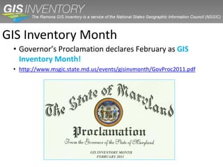
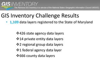
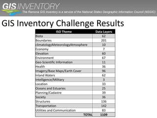
In February 2011 the Maryland State Geographic Information committee launched a three-week challenge to the state’s GIS community to begin inventorying their data in Ramona, the nationwide GIS inventory tool. Ramona helps data producers and consumers by enabling others to learn about the data an agency creates and maintains. Maryland’s Governor Martin O’Malley gave the project a boost by issuing a proclamation declaring February to be GIS Inventory month in Maryland. From framework layers to datasets crucial for situational awareness during emergencies, the Maryland GIS Inventory Initiative encourages entities that have, create, or publish the digital data used in mapping systems to inventory their data. This presentation will focus on how data producers inventory GIS data and how to use Ramona to search and find GIS datasets.
This document presents a case study on using Google Maps to report election results from the 2010 Kenyan referendum. It discusses problems with previous elections, outlines objectives to develop a geospatial approach displaying results, and methodology which included collecting constituency boundary and results data, importing it into Google Fusion Tables, and mapping the results. The results showed support for the referendum, with opportunities to reduce errors and increase transparency in releasing election data to the public online.
This document discusses how Mike O'Leary of Towson University will demonstrate how hackers break into systems and what can be done to reduce risks. It begins by covering physical attacks on Windows systems by booting from alternative media or exploiting features like "Sticky Keys" to bypass logins. It then discusses password attacks like brute force cracking and vulnerabilities in stored passwords. Application-level attacks targeting software like Adobe Reader, Microsoft Office and Adobe Flash are also outlined. Throughout, countermeasures like encryption and using unique, long passwords for accounts are recommended to help secure systems.
The document summarizes key findings from the 2010 Census presented to the 2011 Economic Outlook Conference at Towson University. It includes statewide findings on total population change, population change by age, change by race and Hispanic origin, and impact of foreign born. It also includes jurisdiction findings on total population change, population by age, change by race and Hispanic origin, and impact of foreign born. Charts show data on Maryland's total population change from 1900-2010, percentage population change by decade, and comparison to national population change.
The document discusses the state of the US economy through analysis of several economic indicators. It shows that while GDP growth and consumer spending have increased in the past year, disposable personal income and wages have declined. Unemployment remains high compared to pre-recession levels. While some industries plan to increase hiring, the overall job market recovery has stalled. In summary, the economy has taken two steps forward with GDP and consumption rising, but one step back as incomes, wages and employment are still lagging full recovery.
The document analyzes the current state of the US economy through a variety of economic indicators and metrics. It finds that while the economy is recovering from the recession in some areas such as GDP and job growth, significant challenges remain including high unemployment, declining consumer spending, and issues in the housing and banking sectors. The recovery also faces threats from fiscal and debt crises both domestic and abroad.
The document discusses the need for a revolution in intelligence affairs (RIA) based on changes in the intelligence environment. It analyzes the intelligence community's structure, process, skill sets, and effectiveness using questions adapted from those used to identify previous revolutions. The analysis finds that developments have changed how intelligence is developed and used, requiring changes to structure, skills, and threatening countries that do not adapt. A new intelligence paradigm is needed to solve mysteries in addition to puzzles using classified, open source, and trusted information from global partners. Embracing an RIA will provide advantages over relying solely on traditional practices.
This document provides a summary of a keynote speech given at the Edward V. Badolato Distinguished Speaker Series on homeland security in 2011. The speech reflected on the 10 years since 9/11 and the creation of the Department of Homeland Security. It discussed the history and structure of DHS, including the agencies originally merged to form DHS. It also summarized the impacts of DHS on employment, procurement contracts, and industry growth in Maryland. Finally, it introduced the keynote speaker, Dr. Lenora Gant from the Office of the Director of National Intelligence, to discuss cyber security issues.
Toyota pioneered the use of just-in-time (JIT) inventory control methods. Under JIT, Toyota aims to reduce or eliminate inventories by procuring raw materials only as needed for production. Toyota traces its origins to a loom invented in 1918 that reduced defects, and it launched its first car in 1936. Today, Toyota uses JIT by keeping minimal raw material inventories at each production node and replenishing them as used. This allows Toyota to respond quickly to demand changes without excess inventory costs. Key advantages of JIT for Toyota include lower costs, less waste, and the ability to adapt production quickly.
ACME is considering centralizing its two warehouses into one centralized warehouse to reduce inventory costs while maintaining a 97% service level. Currently, each of ACME's New Jersey and Massachusetts warehouses operate independently to meet 97% of demand. By aggregating demand across locations into one warehouse, ACME can take advantage of risk pooling to reduce demand variability and lower safety stock levels. The document estimates that with centralization, ACME could reduce average inventory levels by around 36% for Product A and 43% for Product B.
This presentation is for the students of Bainbridge Graduate Institute in the Sustainable Operations Course, MGT-564. It provides a high level overview of the most basic tools used by Toyota and lean manufacturing. This is a SlideCast which means there is an AUDIO TRACK, so please turn on your speakers. The presentation is 33 minutes long.
Inventory management and risk pooling are important concepts in supply chain management. General Motors in 1984 had a large logistic network with high inventory levels and transportation costs. Effective inventory management and risk pooling strategies can help companies reduce costs and improve customer service by reducing inventory levels while maintaining the same level of service or improving service with the same inventory. These strategies work best when demands across different locations are negatively correlated as it reduces overall demand variability.
The document discusses production planning in SAP. It covers key modules like sales and operations planning, master production scheduling, material requirements planning, bills of material, work centers, routings and operation costing. The goal of production planning is to integrate sales forecasts with manufacturing capabilities to generate production and procurement plans.
The document summarizes a meeting to discuss building regional information sharing capabilities in Oregon. The meeting's purpose was to share advances in visualization technologies, inform leaders of benefits seen in other areas, and get input on a potential regional information sharing initiative. Key discussion topics included the Virtual USA concept for nationwide emergency information sharing, demonstrations of regional systems in Virginia and Alabama, and updates on Oregon's GIS capabilities, datasets, and efforts to enhance regional data sharing.
2017 GIS in Conservation Track: Using Python and Selenium to Make Geographica...GIS in the Rockies
The document describes how the Bureau of Land Management's LR2000 database can be accessed through Python and Selenium to automate the retrieval and geospatial analysis of mineral leasing records, in order to better understand the spatial patterns and impacts of oil and gas development on public lands over time. It outlines the steps taken to automate searches of the LR2000 database, parse the results into geospatial and attribute tables, and analyze and map the data in ArcGIS. Examples of analyses of oil and gas leasing records in Wyoming and the Grand Staircase-Escalante National Monument area are provided.
The document summarizes Colorado's state GIS activities and services. It outlines the state's plans to improve data sharing and coordination across agencies through its data marketplace and geospatial file transfer site. It also describes some of the key datasets and applications the state is developing, including maps of hydrography, addresses and parcels. The state aims to follow its statutory requirements to develop statewide GIS coordination and a plan to support data exchange between state and local governments.
This document summarizes a panel discussion on parcels data from different perspectives. Representatives from the state, county, city, and private sector shared their views. They discussed goals of having statewide, publicly available parcel data. Benefits included improved permitting, emergency response, and economic development. Counties benefit from more efficient workflows and assessments. Issues included maintaining accurate, up-to-date data. Representatives provided examples of current parcel data availability and online mapping applications in North Dakota. Open data policies and privacy concerns were also discussed. The panel sought feedback to help guide ongoing parcel data coordination efforts.
The Northern Arizona Council of Governments (NACOG) is a regional planning organization that serves a large rural area in northern Arizona covering 47,967 square miles and a population of 334,400 people. NACOG works with local jurisdictions, tribes, and state agencies on transportation planning and project prioritization to improve infrastructure, safety, and mobility in the region. Key activities include analyzing crash data, partnering with tribes, conducting rural transportation studies, and supporting funding applications from the Infrastructure Investment and Jobs Act.
This document summarizes recent developments in national orthoimagery programs. It notes that more aircraft are collecting imagery than previously realized and that consumer options for imagery are greater than ever. It also reports that future funding for the National Agriculture Imagery Program is uncertain. Finally, it outlines Microsoft's efforts to become a significant player in imagery acquisition through its Bing Maps for Enterprise program and 30cm nationwide imagery collection with DigitalGlobe.
The document provides an overview of key geographic areas and concepts used by the US Census Bureau. It discusses the role of geography in the census and describes the Master Address File/TIGER database system used to store address and geographic boundary information. It then summarizes various legal and statistical geographic areas like census tracts, blocks, places, and school districts, as well as programs that utilize census geography like the American Community Survey and Population Estimates Program.
The document discusses opportunities for open spatial data in Trinidad and Tobago, noting that while many government agencies have developed GIS databases and spatial data sets, most of this data is not openly accessible to the public. It outlines issues that need to be addressed like lack of metadata and data sharing policies. The role of The University of the West Indies in supporting open data development and GIS training is also discussed.
Mapchats - Pushing Boundaries; Defining Boundaries at the Census Bureau (Mike...Phil Vu
Michael Ratcliffe is Assistant Division Chief for Geographic Standards, Criteria, Research, and Quality in the Census Bureau’s Geography Division, where he is responsible for geographic area concepts and criteria; address and geospatial data quality; and research activities.
MD iMap is a diverse, flexible system that offers an authoritative online basemap of Maryland, provides Maryland’s citizens and government employees with a wide variety of products and services that assist in capturing, storing, analyzing, managing, and presenting data linked to a location, and supports state performance measurement programs. This workshop will discuss the technical aspects of submitting and using data, and creating basic web mapping applications. Additional ways that MD iMap can be used to make data sharing and display simpler and more streamlined will also be discussed.
This document discusses West Virginia's framework data and web map services. It provides details on statewide imagery, parcel data, streams, geographic names, trails, and other framework layers. These layers are often published as web map services to allow seamless consumption by applications and users. The document highlights WV's efforts to develop and maintain address locators, parcel data, updated streams and land cover that integrate data from state and federal sources into shared services.
The document provides an overview of the Geomatics and Cartographic Research Centre (GCRC) at Carleton University. It discusses the GCRC's research focus areas and projects, including cybercartography, indigenous knowledge, law and policy, open source software, and data collection and mapping projects in various domains. Funding sources for the GCRC are also listed. Guiding principles for the GCRC emphasize open access, open data, open source, consent and data access protocols, and adherence to standards.
Building the Utah Cadastre Through Partnerships (UGIC 2011)SeanAGRC
Slides from Sean Fernandez, Keaton Walker, Rick Kelson (State of Utah AGRC) and Lina Haggard (Utah State Trust Lands, aka SITLA) describe the PLSS, Parcel, GPS Network, and cadastral grant program efforts in Utah to build GIS cadastral data.
Note: Rick Kelson's presentation on the aggregation of county parcels into a statewide database is uploaded separately on slideshare as: Utah SGID: Parcel Layer Activities Update
Texas Geographic Information Officer - Richard WadeTWCA
The document discusses the history and resources of the Texas Natural Resources Information System (TNRIS). TNRIS was established in 1972 as a centralized clearinghouse for natural resource and other socioeconomic data. It provides statewide data like aerial imagery, elevation models, hydrography, and transportation data to Texas agencies and citizens. TNRIS also oversees the Strategic Mapping Program, which develops consistent statewide digital data layers. The director of TNRIS serves as the State's Geographic Information Officer.
URISA and the Development of a Geospatial Society: Past, Present and Future Greg Babinski
This lecture, delivered on December 5, 2012 at the Tsinghua University, Center for Earth Sciences, Redbud Forum on Global Change Science and titled ‘URISA and the Development of a Geospatial Society: Past, Present and Future’ discussed the development of the GMI, with its foundations of the GIS Capability Maturity Model and the Geospatial Management Competency Model. It outlined the future potential of the GMI to advance the development of GIS professional management worldwide.
The document summarizes the current state of GIS within the County of Hawaii government. It outlines that 21 county departments currently use GIS data, though only 5 have designated GIS positions. It then lists over 30 types of geospatial data that are shared between departments and with the public through various online portals. The vision outlined is to create an enterprise GIS system with a unified platform to efficiently share and disseminate standardized data both internally and with the public through web and mobile applications and ArcGIS Online. This would improve the county's use of spatial data across departments.
The document summarizes the state of GIS in Colorado. It discusses how the Governor's Office of Information Technology (OIT) is working to coordinate GIS data across state agencies through initiatives like the Colorado Information Marketplace and a statewide GIS plan. It provides details on specific datasets like hydrography, municipal boundaries, and addresses that are under active stewardship. It also announces an upcoming winter 2015 data call where local governments will be requested to provide updated thematic data to the state.
A GIS can answer five generic questions by analyzing geographic data and features: location, condition, trends, patterns, and modeling. It integrates hardware, software, data, and personnel to capture, store, manipulate, analyze and display geospatial data. Key components of GIS include geospatial data capture through remote sensing, GPS, and digitization; data storage and management in vector and raster formats; data analysis and visualization; and information output.
Similar to GIS Inventory TUgis2011 Presentation (20)
1. The Maryland GIS Inventory
Challenge
This is your state. This is your inventory.
2. What was the GIS Inventory Challenge?
• Maryland’s three-week effort to list the state’s GIS
inventory in Ramona. (February 7 – February 28)
• Created by NSGIC to help both data producers and
data consumers nationwide by providing a
consolidated search for GIS data created by multiple
jurisdictions and agencies.
• Ramona allows others to learn about the data your
agency creates and maintains.
3. Benefits
1. Listing your inventory in Ramona connects you, both
locally and nationally.
2. Listing your inventory in Ramona communicates our
statewide progress and success.
3. Ramona offers an up-to-date inventory by data layer.
4. Ramona creates starter metadata.
5. Ramona offers the ability to generate reports.
4. Benefits
6. The Maryland GIS Inventory Challenge promotes
statewide coordination.
7. Ramona offers convenient search capabilities for GIS
data throughout Maryland, all in one place.
8. Ramona provides the big picture.
9. Ramona provides what one participating state calls an
“online Rolodex of GIS data providers.”
5. GIS Inventory Month
• Governor’s Proclamation declares February as GIS
Inventory Month!
• http://www.msgic.state.md.us/events/gisinvmonth/GovProc2011.pdf
6. Who Completed the Inventory?
• Data Producers
– Local government organizations
– Regional government organizations
– State government organizations
– Commercial providers
7. Expectations
• Not a lot of effort was needed!
• The inventory can be completed in two steps.
1. Create your profile.
2. Inventory individual data layers.
• Approximately 20 minutes to create the profile.
• 30 seconds to 2 minutes per data layer.
8. Framework Layers
The goal was for agencies to list, at a minimum, the following
framework layers in Ramona
• Boundaries • Location
Cities/Towns/Municipalities; Address Points; Geographic Place
Counties; State Names; Geodetic Control Points /
• Elevation Networks
Contours; DEM • Planning/Cadastral
• Imagery/Base Maps/Earth Cover Centroids/Vector Parcels
Orthoimagery/Digital • Transportation
Orthophotography; Land Cover Roads/Street Centerlines; Mass Transit
• Inland Waters Bus/Rail; Railroads
Hydrography; Watershed Boundaries Airports & Airfields
9. GIS Inventory Challenge Results
• 1,109 data layers registered to the State of Maryland
426 state agency data layers
14 private entity data layers
2 regional group data layers
1 federal agency data layer
666 county data layers
10. GIS Inventory Challenge Results
Data
State Agency
Layers
Maryland Department of Natural Resources 130
Maryland Transportation Authority 21
Maryland Department of Housing and Community
5
Development
Maryland Historical Trust 6
Maryland Transit Authority 6
MTA Police Force 1
Maryland Ports Administration 3
Maryland Department of Planning 19
Department of Business and Economic Development 4
Maryland Department of Mental Health and Hygiene 2
Maryland Emergency Management Agency 25
Maryland State Highway Administration 10
Towson University Center for GIS 194
TOTAL 426
11. GIS Inventory Challenge Results
Counties Data Layers
Allegany County Government 38
Anne Arundel County, OIT GIS 72
Baltimore County Government 56
Caroline County 5
Carroll County Government 11
City of Baltimore 1
Dorchester County 61
Frederick County 8
Garrett County Planning & Land Development 24
Harford County 35
Howard County Government 104
Kent County 2
Montgomery County 64
Prince George's County 68
Queen Anne's County 12
Somerset County 6
St. Mary's County 16
Talbot County 7
Washington County 43
Wicomico County 30
Worcester County 3
TOTAL 666
12. GIS Inventory Challenge Results
ISO Theme Data Layers
Biota 62
Boundaries 201
climatologyMeteorologyAtmosphere 10
Economy 7
Elevation 60
Environment 67
Geo-Scientific Information 11
Health 36
Imagery/Base Maps/Earth Cover 96
Inland Waters 62
Intelligence/Military 3
Location 33
Oceans and Estuaries 25
Planning/Cadastre 39
Society 36
Structures 136
Transportation 142
Utilities and Communication 83
TOTAL 1109
13. Next Steps
• Verify contacts & information entered
• Education and outreach
• Continued push for more data
14. What’s in it for you?
• Data consumers:
– The place to go to search for Maryland data
– Search for the data you want, and the website will
direct you to the download page if available
– Participation of data producers is important
15. What’s in it for you?
• Data producers:
– Gets your data out there
– Brings traffic to your website
– Allows other organizations to see what you have
and what you are working on, enabling easier
collaboration
16. Early Adopters
• Private Industry: Chris Holub, Dewberry
– Ramona helps to optimize our data mining process
in the proposal stage by allowing a one-stop portal
for the data that we are looking for.
– It helps to avoid wasted phone calls and emails to
the wrong people when looking for data, saving
time, money, and frustration for both parties.
– We will know that we are getting the most up to
date data directly from the proper source, the first
time we look for it.
17. Early Adopters
• County Government: Rob Slivinsky, Howard County
– Easy to use and create records
– A comprehensive data discovery tool for data seekers
– A tool I can use and send to users asking about my
datasets
– A great place to start documenting your data even if
you do not have metadata
– NSGIC is government based organization
18. Early Adopters
• Federal Government: William Burgess, NSGIC
– FEMA’s Map Modernization Program –staff have administrative
privileges in the system to aid them in locating base imagery and
elevation models for map production.
– The National Digital Orthophoto Programs Committee has access
to the orthoimagery information in Ramona.
– The National Digital Elevation Data Program Committee has
access to the elevation information in Ramona.
– All Federal agencies use the Geospatial One Stop Portal to locate
geospatial data.
– USGS staff have used Ramona to form orthoimagery production
partnerships with end-of-year funds that they needed to quickly
encumber.