SlideShare a Scribd company logo
1 of 32
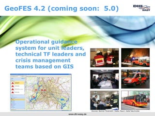
GeoFES 4.2 (coming soon: 5.0)


  Operational guidance
  system for unit leaders,
  technical TF leaders and
  crisis management
  teams based on GIS


                                      Sources: Berliner Feuerwehr, Stefan Rasch, Detlef Machmüller
                    www.dhi-wasy.de
Motivation
• Mission control must be capable of overcoming the „chaos
  phase“ and getting ahead of the situation quickly.
• The aim is to move from reaction to action.
• In order to act, sound information and reliable prognoses are
  needed


Requirements
• Information must be                        • Prognoses must be
      comprehensive,                                   appropriate,
      current,                                         easy to generate,
      swift,                                           sufficiently accurate and
      accessible,                                      quickly available.
      summable, and
      interpretable in a decision-related way.


                                   www.dhi-wasy.de
In „regular“ operations, an operations
commander may face the following
questions:…


                        www.dhi-wasy.de
 What are the surroundings of the operation
  site like, are fire service plans available for
  objects at risk, and where can I find them
  quickly?
 Where is the closest hydrant?
 How long is the hose line needed?
 Where to place the booster pumps?
 Are any hazardous substances close by?
 How many persons are listed as residents in a
  building?
 Which property is the operation taking place at
  and who is the owner?

                      www.dhi-wasy.de
Technical TF leaders and crisis management
are confronted with various additional
questions …


                       www.dhi-wasy.de
 Where is a suited assembly area?
 Where do I best form my operation sections?
 Which extent could the threat take on (if a dam
  fails, or in case of explosion or pollutant dispersal)?
 Is it necessary to evacuate, and if yes, how many
  persons are inside the risk area?
 Where to evacuate to? (where are the closest
  gyms, hotels, … what are their acceptance
  capacities?
 Where do barriers need to be set up?
 Where should casulties be transferred? Where is
  the closest hospital with a particular specialization?
 Which the operational vehicles to be supplied next?

                        www.dhi-wasy.de
GeoFES supports you finding the various answers – the
DSS for unit leaders, technical TF leaders and crisis
management teams


• DSS for daily operation, major and areal
  damage events e.g. following accidents,
  flood events and bomb alerts
• Mobile and stationary (server-based)
  solution
• Desktop and web (vers. 5 or higher)
• As easy as google or bing, but with much
  greater performance


                                        www.dhi-wasy.de
Classification and data exchange
Control center - mobile command post - central
crisis management team

                                                              Central crisis
                       Control                                management
                       center                                 team
                                                              (e.g. fire service,
                                                              county or utilily)


Transmission of operation                            Generel Information exchange
   specifications with                               • Operation Overview (Map based)
• Number                                             • Allocated Ressources
• Keyword                                            • Overview of Damages and Risks
• Operation site                                     • Status messages
• Operation time

Transmission of
   specifications on
   resources with
• Vehicle type
• Vehicle ID                                       Mobile command post (unit
• Staffing                                           leader or technical UL)
• Departure time
• Origin

                                 www.dhi-wasy.de
GeoFES-functional blocks


        Registration and configuration
            Site info/factual info
           Operation management
  Localisation      Analysis area        Analysis
     Operation info             Operation guidance
                 Operation journal


                       www.dhi-wasy.de
GeoFES user interface
1: Task field
2: Tasks
3: Input field for
  selected tasks

                     Werkzeuge und Schalter


                                     www.dhi-wasy.de
Architecture
             “Offline”                         Browser                            “Online”


                                                         WebServer
                             Services


                                                                 Geodata server
Data (geo+
operation)


                                              Internet                               Internet


                         Geodata local         Operational and
                                               geo data in
                         Export/replication
                                               database server
                                                                                                11
Registration and configuration


Administration


Who should be
permitted which views
or actions?


                        www.dhi-wasy.de
Data integration by administration


                    www.dhi-wasy.de
Site information/factual
                 information
                                     GreenInfo as high-
Map object related                    performance tool
information

•   Selected
•   Closest
•   Inside analysis area
•   Inside map area
•   Text search


                           www.dhi-wasy.de
Operation

Operations …

•   Create
•   Administrate
•   Edit
•   Finish
•   Continue


                      www.dhi-wasy.de
Localisation

Localising operation site by …
•   addresses
•   intersections
•   stations
•   objects
•   water bodies
•   motorways


But also
• interactive
• user specific
  objects


Desirable:
Information about
interface from
control center
                             www.dhi-wasy.de
Analysis area

Define analysis area by …

•   radius
•   polygon
•   region
•   buffer
•   modelling
    (chemical substances
    in the air)


                                                           Puffer


       Modelling pollutants dispersion


                                         www.dhi-wasy.de
Analysis area
                                           HWSIM – Flood simulation

             3
1


2

       • Very rapid simulation of
         water propagation due to
         overflow, dam breach and/or
         construction failure
       • Complete integration into
         GeoFES
       • Ad-hoc adoption of flooded
         areas as hazard areas


                                  www.dhi-wasy.de
Analysis

Hazard areas can be analysed by …

•   random themes and objects
•   operation resources
•   risks and hazards
•   measures


                                www.dhi-wasy.de
Analysis

Analysis results can be …

• transformed into checklists
• sent by emails
• or printed


                                www.dhi-wasy.de
Situation maps

Creation of situation maps …

•   per button
•   send by email with another click
•   smartboard support
•   Interactive drawing


                                       www.dhi-wasy.de
Operation
        management
Administration of …

•   action forces
•   operation resources
•   risks
•   damage
•   measures
•   operation sections


                          www.dhi-wasy.de
Generating and publishing reports
Publishing in form of
printouts, email
attachments and/or
webservices, respectively

•   situation maps
•   forces and resources
•   analysis results
•   checklists
•   object information
•   operation journal


                            www.dhi-wasy.de
Operartion journal

Operation journal for …

• documentation
• analysis
• postprocessing

of the operation


                          www.dhi-wasy.de
What you may also find interesting:
Version 5.0 coming soon
    • Fully server enabled (ORACLE, MS SQL server, DB2
      together with ArcGIS server)
    • New user interface (Ribbon style)
    • Web browser enabled
    • Integration calculation program for radiologic
      Problems next to calculation programs for flooding
      and chemical substances
    • Integration of smart devices (ipad, iphone, w-
      mobile)


                          www.dhi-wasy.de
Version 5.0


              www.dhi-wasy.de
Version 5.0


              www.dhi-wasy.de
Version 5.0


              www.dhi-wasy.de
Version 5.0


              www.dhi-wasy.de
Version 5.0


              www.dhi-wasy.de
Version 5.0


              www.dhi-wasy.de
The following
additional
features are
available 


                www.dhi-wasy.de

More Related Content

Similar to GeoFES 4.2 GIS Guidance System

Web-based Geoprocessing with Open Source Software – a 52°North perspective
Web-based Geoprocessing with Open Source Software – a 52°North perspectiveWeb-based Geoprocessing with Open Source Software – a 52°North perspective
Web-based Geoprocessing with Open Source Software – a 52°North perspectiveTheodor Foerster
 
Hadoop Administration pdf
Hadoop Administration pdfHadoop Administration pdf
Hadoop Administration pdfEdureka!
 
Realtime analytics + hadoop 2.0
Realtime analytics + hadoop 2.0Realtime analytics + hadoop 2.0
Realtime analytics + hadoop 2.0Rommel Garcia
 
Realtime Analytics in Hadoop
Realtime Analytics in HadoopRealtime Analytics in Hadoop
Realtime Analytics in HadoopRommel Garcia
 
Jelastic DevOps Platform Product Overview for ISVs
Jelastic DevOps Platform Product Overview for ISVsJelastic DevOps Platform Product Overview for ISVs
Jelastic DevOps Platform Product Overview for ISVsJelastic Multi-Cloud PaaS
 
A Biological Smart Platform for the Environmental Risk Assessment
A Biological Smart Platform for the Environmental Risk AssessmentA Biological Smart Platform for the Environmental Risk Assessment
A Biological Smart Platform for the Environmental Risk AssessmentDavide Nardone
 
FIWARE: Cross-domain concepts and technologies in domain Reference Architectures
FIWARE: Cross-domain concepts and technologies in domain Reference ArchitecturesFIWARE: Cross-domain concepts and technologies in domain Reference Architectures
FIWARE: Cross-domain concepts and technologies in domain Reference ArchitecturesOPEN DEI
 
Cloud fest 2012_jc02
Cloud fest 2012_jc02Cloud fest 2012_jc02
Cloud fest 2012_jc02Jason Carolan
 
Hadoop Adminstration with Latest Release (2.0)
Hadoop Adminstration with Latest Release (2.0)Hadoop Adminstration with Latest Release (2.0)
Hadoop Adminstration with Latest Release (2.0)Edureka!
 
Gis - open source potentials
Gis  - open source potentialsGis  - open source potentials
Gis - open source potentialsTim Willoughby
 
Web 2 0 Utilizing New Web Toolsv.508[1]
Web 2 0 Utilizing New Web Toolsv.508[1]Web 2 0 Utilizing New Web Toolsv.508[1]
Web 2 0 Utilizing New Web Toolsv.508[1]Michael D. Gilley
 
클라우드 컴퓨팅에 따른 데이터센터의 변화
클라우드 컴퓨팅에 따른 데이터센터의 변화클라우드 컴퓨팅에 따른 데이터센터의 변화
클라우드 컴퓨팅에 따른 데이터센터의 변화Fanny Lee
 
Introduction to Cloud Data Center and Network Issues
Introduction to Cloud Data Center and Network IssuesIntroduction to Cloud Data Center and Network Issues
Introduction to Cloud Data Center and Network IssuesJason TC HOU (侯宗成)
 
Big data movement webcast
Big data movement webcastBig data movement webcast
Big data movement webcasttervela
 
What is @hand??
What is @hand??What is @hand??
What is @hand??cleehand
 
Cloudy with a chance of downtime
Cloudy with a chance of downtimeCloudy with a chance of downtime
Cloudy with a chance of downtimeAFCOM
 
DT Company Overview January 2013
DT Company Overview January 2013DT Company Overview January 2013
DT Company Overview January 2013DataTactics
 
Mobile Services & E-Services Case Study By Osama Abushaban
Mobile Services & E-Services Case Study By Osama AbushabanMobile Services & E-Services Case Study By Osama Abushaban
Mobile Services & E-Services Case Study By Osama AbushabanOsama Abushaban
 

Similar to GeoFES 4.2 GIS Guidance System (20)

Web-based Geoprocessing with Open Source Software – a 52°North perspective
Web-based Geoprocessing with Open Source Software – a 52°North perspectiveWeb-based Geoprocessing with Open Source Software – a 52°North perspective
Web-based Geoprocessing with Open Source Software – a 52°North perspective
 
Hadoop Administration pdf
Hadoop Administration pdfHadoop Administration pdf
Hadoop Administration pdf
 
Realtime analytics + hadoop 2.0
Realtime analytics + hadoop 2.0Realtime analytics + hadoop 2.0
Realtime analytics + hadoop 2.0
 
Realtime Analytics in Hadoop
Realtime Analytics in HadoopRealtime Analytics in Hadoop
Realtime Analytics in Hadoop
 
Jelastic DevOps Platform Product Overview for ISVs
Jelastic DevOps Platform Product Overview for ISVsJelastic DevOps Platform Product Overview for ISVs
Jelastic DevOps Platform Product Overview for ISVs
 
A Biological Smart Platform for the Environmental Risk Assessment
A Biological Smart Platform for the Environmental Risk AssessmentA Biological Smart Platform for the Environmental Risk Assessment
A Biological Smart Platform for the Environmental Risk Assessment
 
FIWARE: Cross-domain concepts and technologies in domain Reference Architectures
FIWARE: Cross-domain concepts and technologies in domain Reference ArchitecturesFIWARE: Cross-domain concepts and technologies in domain Reference Architectures
FIWARE: Cross-domain concepts and technologies in domain Reference Architectures
 
Cloud fest 2012_jc02
Cloud fest 2012_jc02Cloud fest 2012_jc02
Cloud fest 2012_jc02
 
Hadoop Adminstration with Latest Release (2.0)
Hadoop Adminstration with Latest Release (2.0)Hadoop Adminstration with Latest Release (2.0)
Hadoop Adminstration with Latest Release (2.0)
 
Gis - open source potentials
Gis  - open source potentialsGis  - open source potentials
Gis - open source potentials
 
Web 2 0 Utilizing New Web Toolsv.508[1]
Web 2 0 Utilizing New Web Toolsv.508[1]Web 2 0 Utilizing New Web Toolsv.508[1]
Web 2 0 Utilizing New Web Toolsv.508[1]
 
클라우드 컴퓨팅에 따른 데이터센터의 변화
클라우드 컴퓨팅에 따른 데이터센터의 변화클라우드 컴퓨팅에 따른 데이터센터의 변화
클라우드 컴퓨팅에 따른 데이터센터의 변화
 
Introduction to Cloud Data Center and Network Issues
Introduction to Cloud Data Center and Network IssuesIntroduction to Cloud Data Center and Network Issues
Introduction to Cloud Data Center and Network Issues
 
A Journey Through Mobile Application Development - Brian Fischer
A Journey Through Mobile Application Development - Brian FischerA Journey Through Mobile Application Development - Brian Fischer
A Journey Through Mobile Application Development - Brian Fischer
 
Big data movement webcast
Big data movement webcastBig data movement webcast
Big data movement webcast
 
What is @hand??
What is @hand??What is @hand??
What is @hand??
 
MHUG - YARN
MHUG - YARNMHUG - YARN
MHUG - YARN
 
Cloudy with a chance of downtime
Cloudy with a chance of downtimeCloudy with a chance of downtime
Cloudy with a chance of downtime
 
DT Company Overview January 2013
DT Company Overview January 2013DT Company Overview January 2013
DT Company Overview January 2013
 
Mobile Services & E-Services Case Study By Osama Abushaban
Mobile Services & E-Services Case Study By Osama AbushabanMobile Services & E-Services Case Study By Osama Abushaban
Mobile Services & E-Services Case Study By Osama Abushaban
 

GeoFES 4.2 GIS Guidance System

  • 1. GeoFES 4.2 (coming soon: 5.0) Operational guidance system for unit leaders, technical TF leaders and crisis management teams based on GIS Sources: Berliner Feuerwehr, Stefan Rasch, Detlef Machmüller www.dhi-wasy.de
  • 2. Motivation • Mission control must be capable of overcoming the „chaos phase“ and getting ahead of the situation quickly. • The aim is to move from reaction to action. • In order to act, sound information and reliable prognoses are needed Requirements • Information must be • Prognoses must be  comprehensive,  appropriate,  current,  easy to generate,  swift,  sufficiently accurate and  accessible,  quickly available.  summable, and  interpretable in a decision-related way. www.dhi-wasy.de
  • 3. In „regular“ operations, an operations commander may face the following questions:… www.dhi-wasy.de
  • 4.  What are the surroundings of the operation site like, are fire service plans available for objects at risk, and where can I find them quickly?  Where is the closest hydrant?  How long is the hose line needed?  Where to place the booster pumps?  Are any hazardous substances close by?  How many persons are listed as residents in a building?  Which property is the operation taking place at and who is the owner? www.dhi-wasy.de
  • 5. Technical TF leaders and crisis management are confronted with various additional questions … www.dhi-wasy.de
  • 6.  Where is a suited assembly area?  Where do I best form my operation sections?  Which extent could the threat take on (if a dam fails, or in case of explosion or pollutant dispersal)?  Is it necessary to evacuate, and if yes, how many persons are inside the risk area?  Where to evacuate to? (where are the closest gyms, hotels, … what are their acceptance capacities?  Where do barriers need to be set up?  Where should casulties be transferred? Where is the closest hospital with a particular specialization?  Which the operational vehicles to be supplied next? www.dhi-wasy.de
  • 7. GeoFES supports you finding the various answers – the DSS for unit leaders, technical TF leaders and crisis management teams • DSS for daily operation, major and areal damage events e.g. following accidents, flood events and bomb alerts • Mobile and stationary (server-based) solution • Desktop and web (vers. 5 or higher) • As easy as google or bing, but with much greater performance www.dhi-wasy.de
  • 8. Classification and data exchange Control center - mobile command post - central crisis management team Central crisis Control management center team (e.g. fire service, county or utilily) Transmission of operation Generel Information exchange specifications with • Operation Overview (Map based) • Number • Allocated Ressources • Keyword • Overview of Damages and Risks • Operation site • Status messages • Operation time Transmission of specifications on resources with • Vehicle type • Vehicle ID Mobile command post (unit • Staffing leader or technical UL) • Departure time • Origin www.dhi-wasy.de
  • 9. GeoFES-functional blocks Registration and configuration Site info/factual info Operation management Localisation Analysis area Analysis Operation info Operation guidance Operation journal www.dhi-wasy.de
  • 10. GeoFES user interface 1: Task field 2: Tasks 3: Input field for selected tasks Werkzeuge und Schalter www.dhi-wasy.de
  • 11. Architecture “Offline” Browser “Online” WebServer Services Geodata server Data (geo+ operation) Internet Internet Geodata local Operational and geo data in Export/replication database server 11
  • 12. Registration and configuration Administration Who should be permitted which views or actions? www.dhi-wasy.de
  • 13. Data integration by administration www.dhi-wasy.de
  • 14. Site information/factual information GreenInfo as high- Map object related performance tool information • Selected • Closest • Inside analysis area • Inside map area • Text search www.dhi-wasy.de
  • 15. Operation Operations … • Create • Administrate • Edit • Finish • Continue www.dhi-wasy.de
  • 16. Localisation Localising operation site by … • addresses • intersections • stations • objects • water bodies • motorways But also • interactive • user specific objects Desirable: Information about interface from control center www.dhi-wasy.de
  • 17. Analysis area Define analysis area by … • radius • polygon • region • buffer • modelling (chemical substances in the air) Puffer Modelling pollutants dispersion www.dhi-wasy.de
  • 18. Analysis area HWSIM – Flood simulation 3 1 2 • Very rapid simulation of water propagation due to overflow, dam breach and/or construction failure • Complete integration into GeoFES • Ad-hoc adoption of flooded areas as hazard areas www.dhi-wasy.de
  • 19. Analysis Hazard areas can be analysed by … • random themes and objects • operation resources • risks and hazards • measures www.dhi-wasy.de
  • 20. Analysis Analysis results can be … • transformed into checklists • sent by emails • or printed www.dhi-wasy.de
  • 21. Situation maps Creation of situation maps … • per button • send by email with another click • smartboard support • Interactive drawing www.dhi-wasy.de
  • 22. Operation management Administration of … • action forces • operation resources • risks • damage • measures • operation sections www.dhi-wasy.de
  • 23. Generating and publishing reports Publishing in form of printouts, email attachments and/or webservices, respectively • situation maps • forces and resources • analysis results • checklists • object information • operation journal www.dhi-wasy.de
  • 24. Operartion journal Operation journal for … • documentation • analysis • postprocessing of the operation www.dhi-wasy.de
  • 25. What you may also find interesting: Version 5.0 coming soon • Fully server enabled (ORACLE, MS SQL server, DB2 together with ArcGIS server) • New user interface (Ribbon style) • Web browser enabled • Integration calculation program for radiologic Problems next to calculation programs for flooding and chemical substances • Integration of smart devices (ipad, iphone, w- mobile) www.dhi-wasy.de
  • 26. Version 5.0 www.dhi-wasy.de
  • 27. Version 5.0 www.dhi-wasy.de
  • 28. Version 5.0 www.dhi-wasy.de
  • 29. Version 5.0 www.dhi-wasy.de
  • 30. Version 5.0 www.dhi-wasy.de
  • 31. Version 5.0 www.dhi-wasy.de