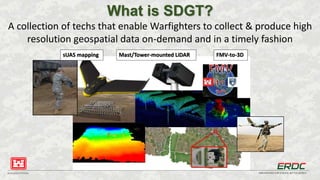
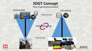
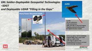
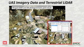
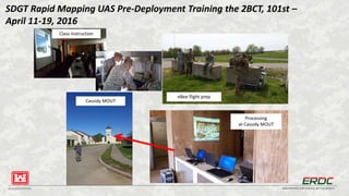
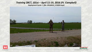
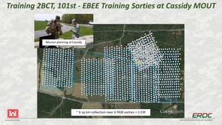
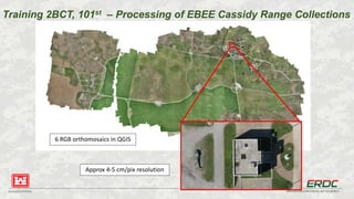
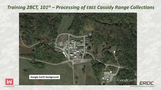
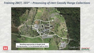
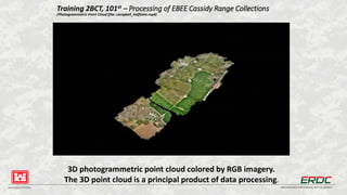
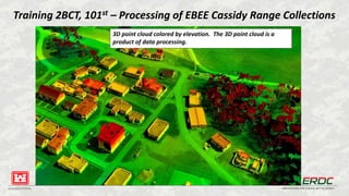
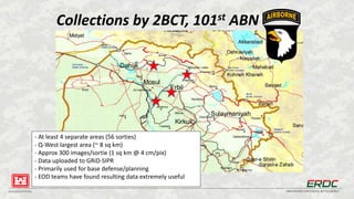
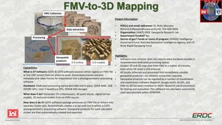
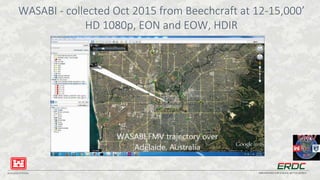
BUILDING STRONG® INNOVATIONS FOR A SAFER, BETTER WORLDBUILDING STRONG® INNOVATIONS FOR A SAFER, BETTER WORLD
Soldier-Deployable Geospatial Technologies
2017 AUSA Annual Meeting & Exposition
Innovators Corner
Dr. Ricky Massaro
Dr. John Anderson
Geospatial Research Laboratory
Engineer Research and Development Center
US Army Corps of Engineers
11 October 2017
UNCLASSIFIED
BUILDING STRONG® INNOVATIONS FOR A SAFER, BETTER WORLD
What is SDGT?
A collection of techs that enable Warfighters to collect & produce high
resolution geospatial data on-demand and in a timely fashion
sUAS mapping Mast/Tower-mounted LiDAR FMV-to-3D
BUILDING STRONG® INNOVATIONS FOR A SAFER, BETTER WORLD
SDGT Concept
Flow of geospatial products
Current paradigm SDGT objective
National Level
Tactical Level
BUILDING STRONG® INNOVATIONS FOR A SAFER, BETTER WORLD
GRL Soldier-Deployable Geospatial Technologies
–SDGT
and Deployable LiDAR “Filling in the Gaps”
• 1.5 lbs
• 45 min endurance
• Fully autonomous
• RGB, CIR, MSI, or thermal imagery
• Rapidly produced orthomosaics
and digital elevation models
• 30 ft mast (80 or 107 ft G-BOSS(E))
• FMCW, SWIR, Class 1 laser radar
• 360º az x 100º el FOV
• LOS range to approx 2 km
• Geopositional accuracy to cm level
• Extremely high resolution
Mast/Tower-Mounted LiDAR
sUAS
BUILDING STRONG® INNOVATIONS FOR A SAFER, BETTER WORLD
UAS Imagery Data and Terrestrial LiDAR
Merged LiDAR and UAS photogrammetric point clouds
BUILDING STRONG® INNOVATIONS FOR A SAFER, BETTER WORLD
Detail view of merged UAS point cloud and LiDAR
BUILDING STRONG® INNOVATIONS FOR A SAFER, BETTER WORLD
SDGT Rapid Mapping UAS Pre-Deployment Training the 2BCT, 101st –
April 11-19, 2016
Cassidy MOUT
eBee flight prep
Processing
at Cassidy MOUT
Class Instruction
BUILDING STRONG® INNOVATIONS FOR A SAFER, BETTER WORLD
Training 2BCT, 101st – April 11-19, 2016 (Ft. Campbell)
Deployment Sortie 1 (file: 20160413_115854.mp4)
BUILDING STRONG® INNOVATIONS FOR A SAFER, BETTER WORLD
Training 2BCT, 101st - EBEE Training Sorties at Cassidy MOUT
~ 6 sq km collection over 6 RGB sorties + 1 CIR
Mission planning at Cassidy
BUILDING STRONG® INNOVATIONS FOR A SAFER, BETTER WORLD
Training 2BCT, 101st – Processing of EBEE Cassidy Range Collections
6 RGB orthomosaics in QGIS
Approx 4-5 cm/pix resolution
BUILDING STRONG® INNOVATIONS FOR A SAFER, BETTER WORLD
Training 2BCT, 101st – Processing of EBEE Cassidy Range Collections
Google Earth background
BUILDING STRONG® INNOVATIONS FOR A SAFER, BETTER WORLD
Resulting superoverlay in Google Earth
Georeg accuracy ~1-2 m horizontal with no GCPs
Training 2BCT, 101st – Processing of EBEE Cassidy Range Collections
BUILDING STRONG® INNOVATIONS FOR A SAFER, BETTER WORLD
Training 2BCT, 101st – Processing of EBEE Cassidy Range Collections
(Photogrammetric Point Cloud (file: campbell_halftime.mp4)
3D photogrammetric point cloud colored by RGB imagery.
The 3D point cloud is a principal product of data processing.
BUILDING STRONG® INNOVATIONS FOR A SAFER, BETTER WORLD
Training 2BCT, 101st – Processing of EBEE Cassidy Range Collections
3D point cloud colored by elevation. The 3D point cloud is a
product of data processing.
BUILDING STRONG® INNOVATIONS FOR A SAFER, BETTER WORLD
Collections by 2BCT, 101st ABN
- At least 4 separate areas (56 sorties)
- Q-West largest area (~ 8 sq km)
- Approx 300 images/sortie (1 sq km @ 4 cm/pix)
- Data uploaded to GRiD-SIPR
- Primarily used for base defense/planning
- EOD teams have found resulting data extremely useful
BUILDING STRONG® INNOVATIONS FOR A SAFER, BETTER WORLD
FMV-to-3D Mapping
Project Information
• POC(s) and email addresses: Dr. Ricky Massaro,
Richard.D.Massaro@usace.army.mil, 703-428-3644
• Organization: USACE-ERDC Geospatial Research Lab
• Government funded? Yes
• Source of gov’t funds or name of program: OUSD(I) Intelligence
Investment Fund, National Geospatial-Intelligence Agency, and US
Army Rapid Equipping Force
Highlights:
• Software-only solution; does not require extra hardware besides a
recommended dedicated processing laptop.
• Creates 2D and 3D map data from FMV in a matter of minutes,
even while ISR asset is still airborne.
• All locally collected and processed into immediately useable
geospatial products – no network connection required.
• Geospatial products can be ingested by a number of visualization
and exploitation software (RaptorX, Google Earth, ArcGIS, etc)
• FMV-to-3D has been installed on NGA’s Research Lab Environment
for testing and evaluation. The software has also been successfully
used operationally within AFRICOM.
Capabilities:
What is it? Software: GOTS & COTS software solution which ingests an FMV file
or live UDP stream from an airborne asset. Automated process extracts
metadata and video frames for importation into a photogrammetric processing
software.
Hardware: Dedicated processing laptop desirable (rec’d specs: 32GB RAM, 2GB
GDDR5 GPU, Intel i7 QuadCore CPU, 500GB SSD storage)
What does it do? Generates 2D orthomosaics, 3D point clouds, digital terrain
models, 3D textured models from an FMV source.
How does it do it? GOTS software package processes an FMV file or stream into
separate cluster sets. Automatically creates a script and runs it within a COTS
photogrammetric processing software. Geospatial products for each calculated
cluster are then automatically created and exported.
FMV Collection
Data extraction
Processing
Geospatial
products
2-D orthos 3-D models
BUILDING STRONG® INNOVATIONS FOR A SAFER, BETTER WORLD
WASABI - collected Oct 2015 from Beechcraft at 12-15,000’
HD 1080p, EON and EOW, HDIR
BUILDING STRONG® INNOVATIONS FOR A SAFER, BETTER WORLD
Thank You!
“Essayons!”

Massaro-UAV Intelligent Transportation Workshop Slides

  • 1.
    BUILDING STRONG® INNOVATIONSFOR A SAFER, BETTER WORLDBUILDING STRONG® INNOVATIONS FOR A SAFER, BETTER WORLD Soldier-Deployable Geospatial Technologies 2017 AUSA Annual Meeting & Exposition Innovators Corner Dr. Ricky Massaro Dr. John Anderson Geospatial Research Laboratory Engineer Research and Development Center US Army Corps of Engineers 11 October 2017 UNCLASSIFIED
  • 2.
    BUILDING STRONG® INNOVATIONSFOR A SAFER, BETTER WORLD What is SDGT? A collection of techs that enable Warfighters to collect & produce high resolution geospatial data on-demand and in a timely fashion sUAS mapping Mast/Tower-mounted LiDAR FMV-to-3D
  • 3.
    BUILDING STRONG® INNOVATIONSFOR A SAFER, BETTER WORLD SDGT Concept Flow of geospatial products Current paradigm SDGT objective National Level Tactical Level
  • 4.
    BUILDING STRONG® INNOVATIONSFOR A SAFER, BETTER WORLD GRL Soldier-Deployable Geospatial Technologies –SDGT and Deployable LiDAR “Filling in the Gaps” • 1.5 lbs • 45 min endurance • Fully autonomous • RGB, CIR, MSI, or thermal imagery • Rapidly produced orthomosaics and digital elevation models • 30 ft mast (80 or 107 ft G-BOSS(E)) • FMCW, SWIR, Class 1 laser radar • 360º az x 100º el FOV • LOS range to approx 2 km • Geopositional accuracy to cm level • Extremely high resolution Mast/Tower-Mounted LiDAR sUAS
  • 5.
    BUILDING STRONG® INNOVATIONSFOR A SAFER, BETTER WORLD UAS Imagery Data and Terrestrial LiDAR Merged LiDAR and UAS photogrammetric point clouds
  • 6.
    BUILDING STRONG® INNOVATIONSFOR A SAFER, BETTER WORLD Detail view of merged UAS point cloud and LiDAR
  • 7.
    BUILDING STRONG® INNOVATIONSFOR A SAFER, BETTER WORLD SDGT Rapid Mapping UAS Pre-Deployment Training the 2BCT, 101st – April 11-19, 2016 Cassidy MOUT eBee flight prep Processing at Cassidy MOUT Class Instruction
  • 8.
    BUILDING STRONG® INNOVATIONSFOR A SAFER, BETTER WORLD Training 2BCT, 101st – April 11-19, 2016 (Ft. Campbell) Deployment Sortie 1 (file: 20160413_115854.mp4)
  • 9.
    BUILDING STRONG® INNOVATIONSFOR A SAFER, BETTER WORLD Training 2BCT, 101st - EBEE Training Sorties at Cassidy MOUT ~ 6 sq km collection over 6 RGB sorties + 1 CIR Mission planning at Cassidy
  • 10.
    BUILDING STRONG® INNOVATIONSFOR A SAFER, BETTER WORLD Training 2BCT, 101st – Processing of EBEE Cassidy Range Collections 6 RGB orthomosaics in QGIS Approx 4-5 cm/pix resolution
  • 11.
    BUILDING STRONG® INNOVATIONSFOR A SAFER, BETTER WORLD Training 2BCT, 101st – Processing of EBEE Cassidy Range Collections Google Earth background
  • 12.
    BUILDING STRONG® INNOVATIONSFOR A SAFER, BETTER WORLD Resulting superoverlay in Google Earth Georeg accuracy ~1-2 m horizontal with no GCPs Training 2BCT, 101st – Processing of EBEE Cassidy Range Collections
  • 13.
    BUILDING STRONG® INNOVATIONSFOR A SAFER, BETTER WORLD Training 2BCT, 101st – Processing of EBEE Cassidy Range Collections (Photogrammetric Point Cloud (file: campbell_halftime.mp4) 3D photogrammetric point cloud colored by RGB imagery. The 3D point cloud is a principal product of data processing.
  • 14.
    BUILDING STRONG® INNOVATIONSFOR A SAFER, BETTER WORLD Training 2BCT, 101st – Processing of EBEE Cassidy Range Collections 3D point cloud colored by elevation. The 3D point cloud is a product of data processing.
  • 15.
    BUILDING STRONG® INNOVATIONSFOR A SAFER, BETTER WORLD Collections by 2BCT, 101st ABN - At least 4 separate areas (56 sorties) - Q-West largest area (~ 8 sq km) - Approx 300 images/sortie (1 sq km @ 4 cm/pix) - Data uploaded to GRiD-SIPR - Primarily used for base defense/planning - EOD teams have found resulting data extremely useful
  • 16.
    BUILDING STRONG® INNOVATIONSFOR A SAFER, BETTER WORLD FMV-to-3D Mapping Project Information • POC(s) and email addresses: Dr. Ricky Massaro, Richard.D.Massaro@usace.army.mil, 703-428-3644 • Organization: USACE-ERDC Geospatial Research Lab • Government funded? Yes • Source of gov’t funds or name of program: OUSD(I) Intelligence Investment Fund, National Geospatial-Intelligence Agency, and US Army Rapid Equipping Force Highlights: • Software-only solution; does not require extra hardware besides a recommended dedicated processing laptop. • Creates 2D and 3D map data from FMV in a matter of minutes, even while ISR asset is still airborne. • All locally collected and processed into immediately useable geospatial products – no network connection required. • Geospatial products can be ingested by a number of visualization and exploitation software (RaptorX, Google Earth, ArcGIS, etc) • FMV-to-3D has been installed on NGA’s Research Lab Environment for testing and evaluation. The software has also been successfully used operationally within AFRICOM. Capabilities: What is it? Software: GOTS & COTS software solution which ingests an FMV file or live UDP stream from an airborne asset. Automated process extracts metadata and video frames for importation into a photogrammetric processing software. Hardware: Dedicated processing laptop desirable (rec’d specs: 32GB RAM, 2GB GDDR5 GPU, Intel i7 QuadCore CPU, 500GB SSD storage) What does it do? Generates 2D orthomosaics, 3D point clouds, digital terrain models, 3D textured models from an FMV source. How does it do it? GOTS software package processes an FMV file or stream into separate cluster sets. Automatically creates a script and runs it within a COTS photogrammetric processing software. Geospatial products for each calculated cluster are then automatically created and exported. FMV Collection Data extraction Processing Geospatial products 2-D orthos 3-D models
  • 17.
    BUILDING STRONG® INNOVATIONSFOR A SAFER, BETTER WORLD WASABI - collected Oct 2015 from Beechcraft at 12-15,000’ HD 1080p, EON and EOW, HDIR
  • 18.
    BUILDING STRONG® INNOVATIONSFOR A SAFER, BETTER WORLD Thank You! “Essayons!”